Mori Atlas logo
National parkTsambagarav Uul National Park

Discover the mapped boundaries and regional geographic context of this Mongolian national park.

Tsambagarav Uul National Park: A Protected Landscape in Bayan-Ölgii Province

Tsambagarav Uul National Park represents a significant protected area within the mountainous terrain of Mongolia's western Bayan-Ölgii Province. As a designated national park, its boundaries delineate a specific protected landscape offering insight into the Altai Mountains' geography. This page serves as a focal point for understanding the park's role in regional conservation and its contribution to the mapped natural heritage of the area.

snow leopard habitatAltai Mountainsmountain wildernessprotected areaglacial landscapehigh-altitude park

Tsambagarav Uul National Park

National park

Park overview

Structured park overview, official facts, and landscape profile for Tsambagarav Uul National Park

Tsambagarav Uul National Park park facts, protected area profile, and essential visitor context
Review the core facts for Tsambagarav Uul National Park, including designation, size, terrain, visitor scale, habitats, and operating context in one park-focused overview.

About Tsambagarav Uul National Park

Tsambagarav Uul National Park occupies a remote corner of western Mongolia within the Altai Mountains, one of Central Asia's great mountain ranges. The protected area was formally established in 2000 and encompasses over 1,100 square kilometres of mountain terrain characterized by glacial valleys, steep ridges, and permanent snow fields. Tsambagarav mountain itself rises prominently above the surrounding landscape, serving as both a geographic landmark and the symbolic heart of the park. The area lies in Bayan-Ölgii Province, Mongolia's westernmost region, a landscape of extraordinary remoteness where vast steppe meets mountain wilderness. This is a landscape shaped by ancient glacial processes, where valleys have been carved by ice and where rock and snow dominate the visual character of the terrain. The park's significance extends beyond its scenic values, however, as it represents one of Mongolia's key conservation areas for some of Central Asia's most threatened wildlife. The high-altitude environment supports a suite of species specially adapted to survive in harsh conditions, with the snow leopard standing as the park's most celebrated inhabitant.

Quick facts and research context for Tsambagarav Uul National Park

Tsambagarav Uul National Park is located in the Altai Mountains of western Mongolia's Bayan-Ölgii Province, spanning roughly 1,110 square kilometres of glacial terrain. The park was established in 2000 and is managed by Mongolia's Ministry of Environment and Green Development. Its defining feature is Tsambagarav mountain, a significant peak that anchors the protected area. The park is internationally recognized for its population of snow leopards, though it also supports other notable species adapted to the harsh high-altitude environment.

Park context

Deeper park guide and search-rich context for Tsambagarav Uul National Park

Tsambagarav Uul National Park history, landscape, wildlife, and travel context
Explore Tsambagarav Uul National Park through its history, landscape character, ecosystems, wildlife, conservation priorities, cultural context, and seasonal travel timing in a structured park guide built for atlas discovery and search intent.

Why Tsambagarav Uul National Park stands out

Tsambagarav Uul National Park is best known for its population of snow leopards, one of the rarest and most elusive big cat species on Earth. The park's glacial mountain landscape, centred on the imposing Tsambagarav peak, represents one of the most ecologically significant protected areas in western Mongolia. The combination of high-altitude rugged terrain, pristine valleys, and relative remoteness has allowed this area to maintain ecological integrity despite increasing pressure on Mongolia's natural landscapes. The snow leopard population places this park among the world's priority sites for conservation of this endangered species.

Tsambagarav Uul National Park history and protected-area timeline

Tsambagarav Uul National Park was established in 2000 as part of Mongolia's expanding network of protected areas during a period of increased environmental governance following the country's transition from a centrally planned to a market economy. The creation of the park reflected a growing recognition of the ecological importance of the Altai Mountains region, particularly its significance as habitat for snow leopards. Mongolia had already established a national network of protected areas in the preceding decades, but the designation of Tsambagarav addressed a gap in protection for the western mountain regions. The park was assigned IUCN Category II status, reflecting its primary purpose of protecting natural ecosystems while allowing for limited sustainable use. Management authority rests with the Ministry of Environment and Green Development of Mongolia, which oversees conservation activities within the protected area.

Tsambagarav Uul National Park landscape and geographic character

The landscape of Tsambagarav Uul National Park is defined by its position within the Altai Mountains, a massive mountain range spanning portions of Mongolia, Russia, China, and Kazakhstan. The terrain is characterized by rugged mountain terrain with steep-walled valleys, rocky ridges, and permanent snow cover on higher elevations. Glacial activity has shaped the region, leaving behind U-shaped valleys, moraines, and alpine lakes that dot the landscape. Tsambagarav mountain itself is a prominent peak that rises dramatically from the surrounding terrain, visible from considerable distances across the western Mongolian steppe. The combination of elevation, latitude, and relative remoteness creates a landscape where harsh winters and brief summers dominate the ecological character. Rock, snow, and sparse vegetation characterize the visual environment, with the palette dominated by grey and brown rock, white snow, and the green of alpine meadows where vegetation can gain a foothold.

Tsambagarav Uul National Park ecosystems, habitats, and plant life

The nature of Tsambagarav Uul National Park reflects the ecological conditions of high-altitude Central Asian mountain environments. The park encompasses a range of habitats from alpine meadows at lower elevations to rock and snow at the highest points. Vegetation is limited by the harsh climate and short growing season, consisting primarily of alpine grasses, sedges, and sparse shrub communities adapted to cold and aridity. The relative remoteness of the area has allowed ecological processes to continue with less disturbance than in more accessible regions of Mongolia. The park forms part of a larger ecosystem connecting to the broader Altai Mountains, allowing for wildlife movements across international boundaries. This connectivity is particularly important for wide-ranging species like the snow leopard that require extensive home ranges.

Tsambagarav Uul National Park wildlife and species highlights

The wildlife of Tsambagarav Uul National Park is distinguished above all by the presence of snow leopards, a species that has become a global symbol of mountain conservation. Snow leopards are exceptionally rare and difficult to observe, making any confirmed population in a protected area a significant conservation achievement. The park's rugged terrain, with its cliffs, rocky outcrops, and steep valleys, provides ideal habitat for this elusive predator. Beyond snow leopards, the park supports other wildlife adapted to the harsh mountain environment, including various species of mountain ungulates that form the prey base for snow leopard populations. The birdlife of the area includes species associated with high-altitude rocky environments. While comprehensive species lists are limited in the available source material, the park's conservation value for snow leopards alone establishes its importance for Central Asian biodiversity.

Tsambagarav Uul National Park conservation status and protection priorities

Tsambagarav Uul National Park represents one of Mongolia's important conservation designations for protecting snow leopard habitat. Snow leopards are classified as vulnerable by the International Union for Conservation of Nature, with populations declining across their range due to poaching, habitat loss, and conflict with livestock herders. Protected areas like Tsambagarav provide essential refuges where these cats can persist away from the primary threats. The park's IUCN Category II designation reflects its primary conservation purpose while acknowledging the possibility of sustainable use activities. Conservation challenges in the region include managing human-wildlife conflict, preventing poaching, and maintaining connectivity with adjacent landscapes. The park forms part of Mongolia's commitment to biodiversity conservation and its obligations under international environmental agreements.

Tsambagarav Uul National Park cultural meaning and human context

The cultural context of Tsambagarav Uul National Park is tied to the broader cultural landscape of western Mongolia, a region with deep ties to traditional pastoralist communities. Bayan-Ölgii Province is known as the heartland of Kazakh culture in Mongolia, with a population maintaining traditional herding lifestyles. The mountains and valleys of the park region have been used by pastoral communities for generations, though the harsh high-altitude environment limits extensive human settlement within the protected area itself. Traditional land use practices in the surrounding landscape reflect centuries of adaptation to the extreme seasonal variations of the Mongolian highlands.

Top sights and standout views in Tsambagarav Uul National Park

Tsambagarav Uul National Park's primary highlight is its status as a snow leopard habitat within the Altai Mountains, one of the most remote and ecologically significant protected areas in Mongolia. The dramatic glacial landscape centred on Tsambagarav mountain provides a scenic backdrop for this conservation imperative. The combination of high-altitude wilderness, relatively intact ecosystems, and the presence of snow leopards makes this park a priority site for conservation in Central Asia. The Altai Mountains setting offers visitors an experience of Mongolia's most rugged and remote mountain environments.

Best time to visit Tsambagarav Uul National Park

The best time to visit Tsambagarav Uul National Park would typically be during the summer months when conditions are most favorable for travel in the high-altitude environment. Summer brings warmer temperatures, more accessible trails, and the vibrant green of alpine meadows in bloom. The brief Mongolian summer provides the narrow window when higher elevations can be comfortably explored. Spring and autumn offer alternative seasons for visitation, though conditions become more challenging with variable weather. Winter visits would be extremely difficult due to harsh conditions and heavy snow that isolates the region.
Park location guide

Geography guide, regional context, and park location map for Tsambagarav Uul National Park

Tsambagarav Uul National Park park geography, regions, and map view in Mongolia
Understand where Tsambagarav Uul National Park sits in Mongolia through a broader geographic reading of the surrounding landscape, nearby location context, and its mapped position within the national park landscape.

How Tsambagarav Uul National Park fits into Mongolia

Mongolia is a landlocked sovereign state in East Asia, known for its vast steppe landscapes, nomadic culture, and historical significance as the heartland of the Mongol Empire founded by Genghis Khan in 1206. The country has a population of approximately 3.5 million people and is the world's most sparsely populated sovereign state. Ulaanbaatar is the capital and largest city, home to roughly half the population.

Wider geography shaping Tsambagarav Uul National Park in Mongolia

Mongolia is located in East Asia, landlocked between Russia to the north and China to the south. The country occupies the Mongolian Plateau and features diverse terrain including grassy steppe, mountains in the north and west, and the Gobi Desert in the south. It covers 1,564,116 km2, making it the second largest landlocked country in the world.

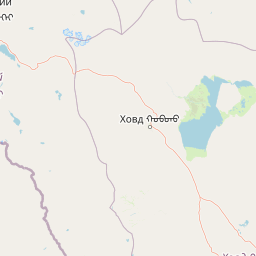
Map view of Tsambagarav Uul National Park

Use this park location map to pinpoint Tsambagarav Uul National Park in Mongolia, understand its exact geographic position, and read its mapped placement within the surrounding landscape more clearly.

Pigeon | © OpenStreetMap contributors

Location context for Tsambagarav Uul National Park

Bayan-Ölgii Province
Park atlas

Compare the diverse protected landscapes, mountain wilderness, and conservation efforts throughout the wider Altai Mountains region.

Explore Nearby National Parks and Protected Areas Around Tsambagarav Uul National Park
Expand your park discovery beyond Tsambagarav Uul National Park to trace the spread of protected areas and glacial landscapes across the rugged Altai Mountains. Compare regional conservation priorities and explore the diverse high-altitude terrain of western Mongolia and its adjacent wilderness through a wider park atlas.
National parkBayan-Ölgii Province

Altai Tavan Bogd National Park: Protected Mountainous Landscape in Bayan-Ölgii

Explore mapped geography and protected terrain.

Altai Tavan Bogd National Park, situated in Mongolia's Bayan-Ölgii Province, offers a detailed view of a significant protected natural area. This park is defined by its mountainous geography, forming a key part of the Altai range. Users can explore its mapped boundaries and understand its role as a protected landscape within the western Mongolian atlas.

Area
6,362 km²
Established
1996
IUCN
II
Relief
Mountain
Watercolor painting showing green mountains, valleys, and a winding river under a light sky
National parkAltai Republic

Saylyugemsky National Park: Discover its Protected Landscape and Geographic Significance in Altai Republic

Mapped boundaries and regional landscape context within the Altai Republic.

Delve into Saylyugemsky National Park, a designated national park situated within the vast geographic expanse of Russia's Altai Republic. This canonical page provides detailed insights into its protected landscape, meticulously mapped boundaries, and its contribution to the regional geography. MoriAtlas focuses on structured geographic discovery, enabling a deeper understanding of Saylyugemsky National Park's place within the atlas of protected areas and natural landscapes.

Area
1,183.8 km²
Established
2012
IUCN
II
Relief
Mountain
National parkBayan-Ölgii Province

Munkhkhairkhan National Park: Alpine Glacial Landscape & Protected Area

Explore the mapped geography of western Mongolia's high peaks.

Munkhkhairkhan National Park protects the dramatic alpine environment surrounding Mönkhkhairkhan Mountain, Mongolia's second-highest peak. This national park showcases spectacular glacial valleys and steep, rock-strewn slopes characteristic of the Mongol-Altai Mountains. As a key protected landscape in Bayan-Ölgii Province, it offers a distinct view into Mongolia's high-elevation ecosystems and their unique mapped boundaries for atlas exploration.

Area
5,061 km²
Established
2011
IUCN
II
Relief
Mountain
National parkKhovd Province

Bulgan Gol-Ikh Ongog National Park: Khovd Province's Vital Riparian Protected Landscape

Mapped geography of river valley, wetlands, and desert steppe.

Bulgan Gol-Ikh Ongog National Park is a designated national park situated in the Khovd Province of western Mongolia, focusing on the preservation of the Bulgan River valley. This protected landscape features a distinctive desert steppe environment interwoven with extensive riparian wetlands, islands, and river channels. The park is ecologically significant as a crucial migratory bird stopover point, supporting diverse habitats that highlight the transition from mountainous sources to the flatter valley floor, offering unique atlas-level geographic insight.

Area
2,461 km²
Established
2011
IUCN
II
Relief
Lowland
National parkUvs Province

Khan-Khokhi Khyargas Mountain National Park: Mapped Boundaries and Protected Landscape

Uvs Province National Park Geography

Khan-Khokhi Khyargas Mountain National Park is a designated national park offering critical insights into Mongolia's protected natural landscapes. This entry supports structured geographic discovery, detailing the park's mapped boundaries and its environmental context within Uvs Province. Engage with the park's identity as a protected area, uncovering its role in the regional atlas and its unique contribution to the mapped terrain.

Area
3,413 km²
Established
2000
IUCN
II
Relief
Mountain
Watercolor painting of a river flowing through forested hills with mountains in the background under a sunset sky
National parkEast Kazakhstan Region

Katon-Karagay National Park: Discover Kazakhstan's Largest Protected Mountain Landscape

Explore the geography and park boundaries of East Kazakhstan's premier national park.

Katon-Karagay National Park, the largest national park in Kazakhstan, offers a deep dive into the protected landscapes of the Southern Altai Mountains. This page provides essential geographic context, detailing the park's terrain, its significance as a protected area within East Kazakhstan Region, and its role in mapping the natural contours of this ecologically diverse mountain system. Understand the park's boundaries and its contribution to regional conservation.

Area
6,435 km²
Established
2001
IUCN
II
Relief
Mountain
National parkZavkhan Province

Ulaagchinii Khar Nuur National Park: Protected National Park in Zavkhan Province

Mapped landscape context and regional geographic setting.

As a dedicated national park, Ulaagchinii Khar Nuur National Park serves as a key protected area within Zavkhan Province. This detail page provides an atlas-oriented view of its mapped boundaries and its role in the regional geography of western Mongolia. Understand the park's specific protected landscape characteristics and its contribution to the mapped natural terrain of the Khangai Mountain region.

Area
2,594 km²
Established
2010
IUCN
II
Relief
Mixed relief
Watercolor painting of green trees, rolling hills, a pink and yellow sunset sky, and a single tree on the right
National parkKrasnoyarsk Krai

Shushensky Bor National Park: Mapped Geography of a Siberian Protected Forest

Explore the protected landscape and regional context of Krasnoyarsk Krai.

Shushensky Bor National Park serves as a critical protected area within the vast geography of Krasnoyarsk Krai, Russia, offering detailed insights into Siberia's ecological transition zones. This national park meticulously maps the shift from the Minusinsk basin forest-steppe to the dramatic mountain taiga of the Western Sayan range. Users can explore its varied terrain, from gentler northern steppe-influenced lands to the rugged slopes of the Borus Massive, all within a defined protected landscape. The proximity to the Sayano-Shushenskoye Reservoir further defines its unique geographic setting, providing context for its conservation importance and natural beauty.

Area
392 km²
Established
1995
IUCN
II
Relief
Mountain

Common questions about visiting, size, designation, and location context for Tsambagarav Uul National Park

Tsambagarav Uul National Park FAQs for park facts, access, geography, and protected area context
Find quick answers about Tsambagarav Uul National Park, including protected-area facts, park geography, trail and visitor context, and how the park fits into its surrounding country and regional landscape.
MoriAtlas Explorer

Continue Your Protected Areas Search Across the Global Atlas

Deepen your exploration by continuing the structured search for national parks and protected areas worldwide. Utilize the comprehensive filtering capabilities to compare different conservation landscapes and refine your understanding of global park geography. Discover more about the distribution and characteristics of protected natural areas.

Global natural geography