Mori Atlas logo
Protected landscapeVon-Bach-Erholungsgebiet

Explore the unique terrain where central Namibian bushveld meets critical freshwater reservoir infrastructure.

Von-Bach-Erholungsgebiet Protected Landscape and Dam Geography in the Otjozondjupa Region

Von-Bach-Erholungsgebiet serves as a distinctive protected landscape set against the northern foothills of the Eros Mountains in central Namibia. The area centers on the Von-Bach Dam, providing a hybrid environment where reservoir-based recreation intersects with acacia bushveld and rocky terrain. This geographic record maps the transition from high-ground ridges to the expansive water surface, offering insight into a primary recreation reserve located near the capital city of Windhoek.

Namibiarecreation reserveOtjozondjupacentral Namibiafreshwater damEros Mountains foothills

Von-Bach-Erholungsgebiet

Protected landscape

Park overview

Structured park overview, official facts, and landscape profile for Von Bach Recreation Resort

Von Bach Recreation Resort park facts, protected area profile, and essential visitor context

Review the core facts for Von Bach Recreation Resort, including designation, size, terrain, visitor scale, habitats, and operating context in one park-focused overview.

About Von Bach Recreation Resort

Von Bach Recreation Resort is a small protected landscape in central Namibia that pairs a working freshwater reservoir with a surrounding game park. Covering about 43 square kilometers in the Otjozondjupa Region, it sits in the northern foothills of the Eros Mountains, roughly five kilometers southeast of the town of Okahandja and within easy reach of the capital, Windhoek. The reserve was formally established in 1972 and is managed under Namibia's protected-area system as an IUCN Category V Protected Landscape.

At the heart of the area lies the Von Bach Dam, one of the larger freshwater impoundments supplying Windhoek with municipal water. The dam's broad, calm waters and the surrounding acacia-studded hill country create an unexpected oasis of blue in Namibia's otherwise arid central plateau. Because the reservoir serves an essential role in regional water supply, the recreation reserve functions both as a conservation landscape and as a piece of urban-supporting infrastructure.

While the area does include a wildlife component, its terrain is poorly opened up by the single road that crosses it, which limits game-viewing opportunities. As a result, the resort's character leans heavily toward water-based recreation and short-stay leisure rather than traditional safari tourism. Visitors come for water skiing, canoeing, swimming, and angling on the dam, and to use the campsite as a base for weekend stays. A restriction on dogs and motorcycles helps preserve the relaxed character of the site, and the rule that day visitors must leave by sunset keeps the area calm after dark.

Within Namibia's broader protected-area network, Von Bach takes its place alongside reserves such as Daan Viljoen, Gross Barmen, and Hardap as a small, accessibility-focused recreation reserve rather than a remote wilderness park. Its usefulness lies precisely in its modest scale and proximity to the country's main urban corridor, providing an approachable nature experience within a short drive of Windhoek.

Quick facts and research context for Von Bach Recreation Resort

Von Bach Recreation Resort is a 43 square kilometer protected landscape in the Otjozondjupa Region of central Namibia, formally established in 1972 and administered by the Ministry of Environment and Tourism. It lies southeast of Okahandja, in the northern foothills of the Eros Mountains, and is classified by the IUCN as a Category V Protected Landscape/Seascape.

The reservoir at its center supplies freshwater to Windhoek, while the surrounding reserve supports a small wildlife population. The area is designed primarily as a recreation destination, with angling, water sports, and camping rather than large-scale wildlife viewing as its main draws.

Protection and recognition

Documented terrestrial protection scope and administrative database tracking

Von-Bach-Erholungsgebiet Protection Status and Designated Area Record

Terrestrial protection status records for Von-Bach-Erholungsgebiet outline documented administrative boundaries and conservation parameters. Structured database metrics compile official management details and international registry markers without assuming active designation outcomes.

Protection details

Protection scope
Terrestrial
Transboundary protection
No
WDPA ID
18004
Park context

Deeper park guide and search-rich context for Von Bach Recreation Resort

Von Bach Recreation Resort history, landscape, wildlife, and travel context

Explore Von Bach Recreation Resort through its history, landscape character, ecosystems, wildlife, conservation priorities, cultural context, and seasonal travel timing in a structured park guide built for atlas discovery and search intent.

Why Von Bach Recreation Resort stands out

Von Bach Recreation Resort is best known for the Von Bach Dam, a large freshwater reservoir for Windhoek that doubles as the focal point of a protected recreation landscape. Visitors associate the area with reservoir-based water sports, an easily accessible weekend escape from the capital, and a small adjoining game park set against the Eros Mountain foothills. Its identity is shaped by the unusual combination of municipal water infrastructure and recreational wildlife area. Few Namibian reserves are built around a working drinking-water dam, and this overlap gives Von Bach a hybrid character that sets it apart from the country's more remote national parks.
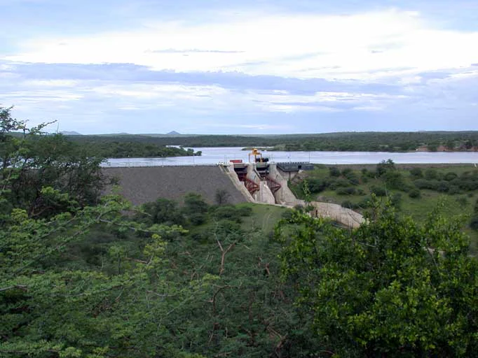
A wide shot showing the Von Bach Dam structure holding back a large reservoir, surrounded by lush green bushveld vegetation under an overcast sky.
A wide view of the Von Bach Dam reservoir, the central feature of the Von Bach recreation area in Namibia.

Von Bach Recreation Resort history and protected-area timeline

The Von Bach Recreation Resort was formally established in 1972 as a protected landscape in central Namibia. Its creation was tied to the existence of the Von Bach Dam, which had already been developed to secure freshwater supplies for the growing city of Windhoek. Rather than treating the reservoir and its surroundings purely as utility infrastructure, the authorities brought the adjoining hills and bushveld under formal protection, creating a recreation-focused reserve centered on the dam.

Since its designation, the area has been administered through Namibia's national protected-area framework as a small-scale recreation resort serving urban residents from Windhoek and the surrounding towns. Its long-standing classification as an IUCN Category V Protected Landscape reflects its enduring purpose as a combined outdoor recreation and light conservation area, rather than as a strictly wilderness-focused national park.

Von Bach Recreation Resort landscape and geographic character

The landscape of Von Bach Recreation Resort is shaped by the meeting of the northern foothills of the Eros Mountains and the still waters of the Von Bach Dam. The terrain consists of gently rolling hills and low ridges typical of central Namibia's khaki bushveld, with vegetation dominated by thorny acacia woodland, tall grasses, and scattered rocky outcrops. The rugged character of the surrounding hills frames the smooth blue surface of the reservoir, giving visitors a striking visual contrast that is relatively unusual in this arid region.

Within the reserve, the single road network passes through this bushveld setting, but the topography and dense vegetation limit how well visitors can explore the interior by vehicle. From the dam's shoreline, the views extend across the water toward the receding slopes of the Eros Mountains, while the surrounding bush gives the area an open, lightly wooded character rather than the dense forest or true wilderness of the country's larger parks. The result is a relatively compact and accessible landscape where dam, hill, and bushveld combine into a single modest but distinctive setting.

Von Bach Recreation Resort ecosystems, habitats, and plant life

The ecological character of Von Bach Recreation Resort is defined by central Namibian bushveld and the freshwater habitat created by the dam. The surrounding hills support typical thornveld vegetation of the region, with acacia species, mopane-type shrubs, drought-adapted grasses, and the hardy woody plants that thrive in this semi-arid transition zone between the central plateau and the Kalahari fringe.

The reservoir itself introduces a contrasting habitat, turning a small area of the reserve into a freshwater ecosystem that supports waterbirds, aquatic life, and the riparian vegetation that lines its banks. This combination of dry bushveld and open water within a single small reserve gives the site more ecological variety than its modest size would suggest, and it is this mix that underpins the area's value for both wildlife and recreation.

Von Bach Recreation Resort wildlife and species highlights

Wildlife at Von Bach Recreation Resort is shaped by the small wildlife park that surrounds the dam rather than by the water body itself. The bushveld supports typical central Namibian game, with antelope and smaller mammals suited to the thorny acacia woodland and semi-arid conditions. While the single access road and dense vegetation limit game-viewing opportunities, the reserve functions as a complementary wildlife area to its water-focused recreation facilities.

The dam, meanwhile, attracts waterbirds and supports freshwater fish populations that sustain the area's angling activity. Together, the reservoir and its surrounding bush provide a modest but recognizable wildlife presence that contributes to the reserve's character without making it a major safari destination in the way that Etosha or Waterberg do.

Von Bach Recreation Resort conservation status and protection priorities

Von Bach Recreation Resort contributes to Namibia's conservation network as a formally recognized Protected Landscape rather than as a strict nature reserve. Its formal IUCN Category V designation signals that its primary purpose is landscape protection combined with recreation, which suits its role as a small, accessible reserve near the country's capital.

The dam itself is a major component of the site's conservation value, because it secures freshwater for Windhoek while also creating a protected riparian and aquatic habitat in an otherwise dry region. By keeping the surrounding hills and bushveld under formal protection, the reserve safeguards a representative patch of central Namibian bushveld, even though its smaller scale and lower wildlife densities place it firmly in the light-conservation and recreation category of Namibia's protected areas.

Von Bach Recreation Resort cultural meaning and human context

Von Bach Recreation Resort sits within the Otjozondjupa Region, an area of central Namibia with a long heritage of cattle ranching, dam construction, and small-town settlement. Its location near Okahandja, historically a waypoint between central Namibia and the north, links it to the regional patterns of small reserves that serve urban populations rather than to remote wilderness tourism in places like the Namib or the Kavango. The site's leisurely character, with camping and watersport rather than mass tourism, reflects the role of dam-based recreation in Namibian urban life, where reservoirs have long functioned as weekend destinations for nearby towns.

Top sights and standout views in Von Bach Recreation Resort

The strongest points of distinction at Von Bach Recreation Resort are its dual identity as a freshwater reservoir for Windhoek and as a recreation-focused protected landscape. The dam's broad waters support water sports, angling, and waterbird habitat, while the surrounding foothills of the Eros Mountains provide a backdrop of central Namibian bushveld that hosts a small wildlife population.

The reserve's proximity to Windhoek and Okahandja makes it one of the most accessible combination reservoir-and-game environments in Namibia, and the simple on-site camping and day-visit rules reinforce its function as an easy weekend retreat. Its long-standing status as a 1972-established protected landscape also makes it an established fixture in Namibia's network of recreation reserves.

Best time to visit Von Bach Recreation Resort

Von Bach Recreation Resort is primarily a water-based recreation destination, so seasons that support comfortable outdoor and water activity are most rewarding. In central Namibia, the cooler and drier months tend to bring stable, sunny conditions that suit water skiing, canoeing, swimming, and lakeside camping, while the hotter peak of summer can make daytime activity on and around the dam more demanding.

Because the surrounding game area is lightly stocked and accessed by a single road, the park experience is comparatively consistent throughout the year, with seasonal changes mainly affecting water levels, the openness of the bush, and the comfort of outdoor leisure rather than dramatically shifting wildlife visibility. As a result, planning to visit in line with cooler, drier weather typically offers the most comfortable overall experience for a weekend or day visit.
Monthly climate preview

Long-term representative temperature and monthly precipitation averages

Von-Bach-Erholungsgebiet Climate Normals and Annual Temperature Patterns

Representative coordinate records show measured monthly temperature ranges and precipitation rhythms across the protected terrain. Analyzing complete monthly climate normals reveals deeper shifts in long-term atmospheric patterns for this location.
Annual mean22 °C
14 °C26 °C
Jan26°
Feb25°
Mar24°
Apr21°
May18°
Jun15°
Jul14°
Aug17°
Sep22°
Oct25°
Nov26°
Dec26°
Warmest month
December

26.3 °C

Coolest month
July

14.4 °C

Wettest month
February

2.9 mm/day

Driest month
July

0 mm/day

Park location guide

Geography guide, regional context, and park location map for Von Bach Recreation Resort

Von Bach Recreation Resort park geography, regions, and map view in Namibia

Understand where Von Bach Recreation Resort sits in Namibia through a broader geographic reading of the surrounding landscape, nearby location context, and its mapped position within the national park landscape.

How Von Bach Recreation Resort fits into Namibia

Namibia is a sovereign country in Southern Africa that gained independence from South Africa in 1990. It is the driest country in sub-Saharan Africa, characterized by the Namib Desert along its coast. The population is approximately 3 million, with Windhoek as the capital and largest city. Namibia operates as a unitary semi-presidential republic with a multi-party system.

Wider geography shaping Von Bach Recreation Resort in Namibia

Namibia occupies 825,615 km2 in Southern Africa, making it the 34th largest country in the world. It is bordered by the Atlantic Ocean to the west, Angola and Zambia to the north, Botswana to the east, and South Africa to the south. The country features the Namib Desert along its coastal region, with varied terrain including savannas, mountains, and plateaus inland. A notable geographic feature is that Zimbabwe lies less than 200 metres away along the Zambezi river near Kazungula in the northeast.

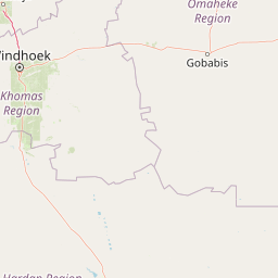
Map view of Von Bach Recreation Resort

Use this park location map to pinpoint Von Bach Recreation Resort in Namibia, understand its exact geographic position, and read its mapped placement within the surrounding landscape more clearly.

Pigeon | © OpenStreetMap contributors

Location context for Von Bach Recreation Resort

Otjozondjupa

Visual reference for the reservoir and surrounding bushveld terrain

Von-Bach-Erholungsgebiet Photos: Scenery and Landscapes

Visual documentation captures the unique meeting of open water and dry acacia bushveld across the protected reserve. Photographic records reveal the stark contrast between the still reservoir surface and the rugged hills of the Eros Mountain foothills.

A wide shot showing the Von Bach Dam structure holding back a large reservoir, surrounded by lush green bushveld vegetation under an overcast sky.

A wide view of the Von Bach Dam reservoir under an overcast sky, with dense green vegetation in the foreground and rocky hills in the distance.

Park atlas

Compare regional reserves and connected bushveld terrain across central Namibia

Explore Parks Near Von-Bach-Erholungsgebiet and Surrounding Protected Landscapes

Browsing other protected areas near Von-Bach-Erholungsgebiet reveals a diverse network of regional reserves and wildlife habitats across the central plateau. Comparing adjacent landscapes provides valuable geographic context for understanding the broader terrain surrounding the Eros Mountain foothills.
A horizontal watercolor illustration of rolling hills, trees with soft pink and green foliage, and grassy foreground against a pale misty mountain background.
Protected areaNamibia
About 25 km away#1 closest

Southwest

Gross Barmen Protected Area: Landscape Geography and Thermal Spring Mapping in Namibia

Central Namibia thermal spring and historic natural monument

Gross Barmen is a state-managed recreation area in central Namibia, centered on a natural sulfurous spring that emerges within a flat thornveld landscape. This protected area acts as both a cultural heritage site and a geological feature, providing a clear window into the regional terrain of the Otjozondjupa area through its thermal waters and historical mission foundations.

Area
1 km²
Established
1968
Relief
Lowland
Climate
Arid
Nature reserveWindhoek
About 64 km away#2 closest

South

Südwest-Naturreservat: A Protected Botanical Nature Reserve in Central Windhoek

Conservation landscapes and native flora in the Khomas Highland

Located in central Windhoek, Südwest-Naturreservat functions as a key protected area and botanical site. It showcases a diverse collection of Namibian plants across both landscaped and natural terrain, offering a focused look at arid and semi-arid flora within an accessible urban environment that highlights the region's unique biodiversity.

Area
0.12 km²
Established
1970
IUCN
V
Relief
Upland
Wildlife reserveOtjozondjupa
About 120 km away#3 closest

North

Okonjati Game Reserve: Mapped Protected Landscapes and Wildlife Geography in Namibia

Ecological terrain and historical mountain setting in Otjozondjupa.

Situated in the heart of Namibia, Okonjati Game Reserve represents a significant private conservation effort centered on the Etjo massif. This 360 square kilometer protected landscape features a blend of rocky uplands and savanna plains, providing a unique habitat for rhinoceroses, elephants, and hippopotamuses while preserving fossilized dinosaur tracks and modern historical landmarks.

Area
360 km²
Established
1975
Relief
Upland
Climate
Arid
National parkNamibia
About 153 km away#4 closest

Southwest

Namib-Naukluft National Park: Namibia's Iconic Desert Landscape and Protected Terrain

Explore its ancient dunes, Naukluft mountains, and coastal geography.

Namib-Naukluft National Park is a colossal protected area in Namibia, holding the distinction of being Africa's largest national park. This park is renowned for its iconic sand dunes, particularly at Sossusvlei, which are among the highest in the world and display dramatic colors due to iron oxidation. The landscape also features the rugged Naukluft Mountains and vital coastal fog zones, creating a diverse arid environment. Delve into the mapped geography and unique terrain of this ancient desert setting, understanding its protected landscape significance within Namibia's atlas.

Area
49,768 km²
Established
1907
IUCN
II
Relief
Mixed relief
National parkNamibia
About 156 km away#5 closest

North

Waterberg Plateau Park: A Detailed Atlas of a Protected Table Mountain in Namibia

Geographic overview of the Kalahari plateau ecosystem and protected wilderness

Waterberg Plateau Park offers a deep look into one of Namibia's most recognizable natural landmarks, featuring a classic table mountain formation that rises dramatically from the savannah. This protected area provides a rich study of geological heritage, including ancient strata and isolated plateau ecosystems that support a wide range of bird species and rare fauna. The park serves as a foundational site for conservation, marking a contrast between the elevated plateau and the expansive plains below.

Area
405 km²
Established
1972
IUCN
II
Relief
Highland
Watercolor illustration of a landscape with soft green and pink hues showing rolling hills and a pale sky
National parkNamibia
About 178 km away#6 closest

North

Waterberg Plateau Park: Mapped Geography and Protected Landscape Identity in Namibia

Central Namibia's ancient plateau and savanna terrain.

Waterberg Plateau Park stands as a defining geological feature of the Namibian landscape. This national park is centered on a dramatic table mountain that creates a distinct ecological island above the surrounding Kalahari basin. Renowned for its ancient rock formations and successful conservation efforts, the area provides a vital protected boundary for endangered species and a significant focus for regional geographic exploration.

Area
405 km²
Established
1972
IUCN
II
Relief
Mixed relief
National parkNamibia
About 217 km away#7 closest

Southwest

Dorob National Park: Namibia's Expansive Coastal Desert and Protected Bird Habitat

Explore mapped landscapes and regional geography.

Dorob National Park is a prime example of a protected coastal desert landscape, stretching along Namibia's Atlantic coast. This national park is renowned for its significant bird populations, making it an Important Bird Area with extensive mapped habitats supporting diverse species. Understand the park's geographic context, from its dramatic dunes to its ephemeral river systems, and its role as a key conservation area within the region.

Area
107,540 km²
Established
2010
IUCN
II
Relief
Lowland
National parkKunene Region
About 280 km away#8 closest

North

Etosha National Park National Park: Mapped Protected Landscape and Regional Geography

Discover its protected boundaries and geographic context.

Gain a structured understanding of Etosha National Park, a prominent national park within Namibia's Kunene Region. This entry focuses on the park's protected landscape identity, detailing its mapped boundaries and geographic significance. Explore Etosha National Park through the lens of atlas-driven discovery, appreciating its role as a key protected area and its contribution to the regional geography of the surrounding landscape.

Area
22,270 km²
Established
1907
IUCN
II
Visitors
200K annual

Common questions about visiting, size, designation, and location context for Von Bach Recreation Resort

Von Bach Recreation Resort FAQs for park facts, access, geography, and protected area context

Find quick answers about Von Bach Recreation Resort, including protected-area facts, park geography, trail and visitor context, and how the park fits into its surrounding country and regional landscape.
MoriAtlas Explorer

Continue Your Protected Areas Search Across the Global Atlas

Deepen your exploration by continuing the structured search for national parks and protected areas worldwide. Utilize the comprehensive filtering capabilities to compare different conservation landscapes and refine your understanding of global park geography. Discover more about the distribution and characteristics of protected natural areas.

Global natural geography