Why Wadi Gaza Nature Reserve stands out
The reserve is best known for sheltering the only coastal wetland of any meaningful size that remains in the Gaza Strip, a habitat type almost entirely lost to development along the eastern Mediterranean shore. Its position on the Palaearctic to Africa bird migration flyway gives it an outsized importance for migratory waterbirds and shorebirds, and this role drove its earlier recognition as an Important Bird Area. The narrow band of protected wadi cutting through one of the most densely populated stretches of coastline in the world also makes it a notable example of urban-adjacent wetland conservation.
Wadi Gaza Nature Reserve history and protected-area timeline
The push to protect the Wadi Gaza area began in 1998, when researchers first documented the need for formal safeguards around the wetland habitats along the lower course of the wadi. Subsequent surveys identified the extent and ecological value of these habitats and laid the groundwork for a reserve designation. The initial proposal envisioned a broader protected landscape around the wadi, but local opposition led to a much narrower boundary being adopted.
In June 2000 the Environment Quality Authority of the Palestinian Authority formally declared the Wadi Gaza Nature Reserve, limiting protection to the course of the wadi along with its floodplain and banks within the Gaza Strip. The reserve had earlier been recognized as an Important Bird Area because of the wadi's position on a major north Palaearctic to Africa migration flyway, and the formal declaration built on this international bird conservation status. In April 2012 the Wadi Gaza coastal wetlands were submitted for inclusion on the UNESCO World Heritage tentative list, cementing the area's standing as a landscape of recognized biodiversity and cultural value.
Wadi Gaza Nature Reserve landscape and geographic character
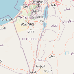
Within the Gaza Strip the reserve follows a roughly nine-kilometer reach of the Wadi Gaza, compared with a much longer total course of about one hundred and five kilometers upstream. The channel makes eight major changes in direction as it crosses the strip, and its width fluctuates from around twenty meters in narrow stretches to about two hundred and seventy meters near the mouth where the wadi meets the sea. The protected corridor includes the active riverbed, the floodplain that spreads out around it, and the immediate banks, producing a fluid mosaic of exposed sand, vegetated margins, and standing or seasonal water.
The wadi mouth lies on the Mediterranean coast near the southern edge of Gaza city, where the channel opens into a low coastal strip. The reserve's northern boundary is set by the lands of Al-Zahra', Al-Mughraqa, and the Wadi Gaza village council, while the southern boundary is defined by the refugee camps of Nuseirat and Bureij. The wider coastal setting surrounds the wadi with built-up neighborhoods, farmland, and infrastructure, so the reserve reads as a conspicuous ecological seam running through an otherwise urbanized coast.
Wadi Gaza Nature Reserve ecosystems, habitats, and plant life
The nature of the reserve is defined by wetland and riparian habitats in an otherwise heavily developed coastal setting. The wadi corridor supports a sequence of open water, marshy margins, reedbeds, and sand or silt banks, depending on the season and the area of the floodplain being inundated. Adjacent agricultural land and fallow fields extend the habitat mosaic outward, blurring the formal boundary between the protected wadi and its working landscape.
This combination of habitats is what makes the reserve ecologically distinctive. Coastal wetlands along the eastern Mediterranean have largely been lost to drainage, reclamation, and urban growth, and the Wadi Gaza system retains a rare example of the original mosaic of seasonal pools, marsh, and tidal-influenced margins near the coast. The result is a small but disproportionately rich refuge for species adapted to wetland, coastal, and transitional habitats, set against an intensively used rural and urban backdrop.
Wadi Gaza Nature Reserve wildlife and species highlights
The reserve is most notable for its role as a refuge and wintering area for migratory waterbirds and shorebirds, reflected in its earlier recognition as an Important Bird Area. The wadi lies on a major flyway linking breeding grounds in the northern Palaearctic with wintering areas in Africa, meaning that at different seasons the reserve can host a varied community of ducks, herons, waders, gulls, and smaller passerine migrants. Beyond birds, the wetland margins and adjacent fields provide habitat for reptiles, small mammals, and a range of invertebrates associated with damp soils and seasonal water bodies.
Because the reserve is narrow and surrounded by human settlement, the wildlife profile is shaped as much by what birds and other animals can pass through or stop over in a compressed coastal strip as by a fully self-contained ecosystem. The result is a small protected area that punches well above its size in terms of the diversity and conservation value of the bird life it supports.
Wadi Gaza Nature Reserve conservation status and protection priorities
The reserve's conservation importance rests on preserving one of the last functioning coastal wetland systems on the eastern Mediterranean coast and on safeguarding a key node on the north Palaearctic to Africa bird migration flyway. These twin roles, as a refuge for resident wetland biodiversity and as a hub for migratory species, were the basis for its original Important Bird Area designation and continue to shape its management priorities.
The reserve's protection history also illustrates the challenge of conserving nature in a densely populated and politically pressured environment. The formal boundaries were scaled back from a wider landscape to the current narrow corridor under local opposition, and ongoing urban expansion, infrastructure, and land development continue to place pressure on the wadi and its floodplain. Submission of the Wadi Gaza coastal wetlands to the UNESCO World Heritage tentative list in April 2012 reinforced the international significance of the site and added a further layer of recognized value to efforts to sustain the reserve.
Wadi Gaza Nature Reserve cultural meaning and human context
The reserve sits within a richly populated landscape that shapes its identity as much as its ecology. To the north it abuts the localities of Al-Zahra', Al-Mughraqa, and the Wadi Gaza village council, while to the south it meets the refugee camps of Nuseirat and Bureij, both of which are central parts of the social and demographic fabric of the Gaza Strip. The wadi itself has long been a defining geographic feature for communities along its banks, supplying seasonal water and shaping patterns of settlement and agriculture.
The negotiation over the reserve's boundaries also records a moment in the local social history of the area, reflecting how rural communities and conservation authorities balanced land use, agriculture, and protection within the narrow coastal plain. The reserve is therefore not only a natural landscape but also a marker of the relationship between Gaza's population and one of its few remaining natural corridors.
Top sights and standout views in Wadi Gaza Nature Reserve
The reserve protects the only coastal wetland of any scale left in the Gaza Strip and one of the few surviving examples along the eastern Mediterranean coast, making it a rare refuge of natural habitat in an otherwise heavily developed shoreline.
It is recognized internationally as an Important Bird Area, owing to its position on a main north Palaearctic to Africa migration flyway, and the wider Wadi Gaza coastal wetlands were placed on the UNESCO World Heritage tentative list in April 2012.
Best time to visit Wadi Gaza Nature Reserve
The character of the reserve changes with the seasons in step with rainfall, river flow, and bird migrations. Migratory and wintering periods, when waterbirds and shorebirds concentrate on the wadi and its coastal margins, are the most rewarding times for birdwatching and for observing the wetland at its fullest. Warmer months tend to bring lower water levels and expose more of the wadi bed and its seasonal plant communities, giving a different but equally worthwhile perspective on the landscape. Because the reserve is narrow and heavily bordered by communities, the experience is shaped as much by its human surroundings as by the natural setting, and visits benefit from an awareness of local conditions and access considerations at any given time of year.