Mori Atlas logo
Nature reserveWadi Mujib

Discover the unique geography and biodiversity of this dramatic rift valley gorge.

Wadi Mujib Nature Reserve: Jordan's Premier Canyon Protected Landscape Atlas

(Mujib Biosphere Reserve)

Wadi Mujib Nature Reserve in Jordan offers a stunning exploration of a dramatic desert canyon landscape carved by millennia of geological processes. Situated east of the Dead Sea, this protected area showcases an extraordinary topographic range, from below sea level to mountain peaks, revealing intricate slot canyons and arid biodiversity along its tributaries. Understanding Wadi Mujib involves appreciating its mapped boundaries, its role as a vital migratory bird flyway, and its designation as a UNESCO biosphere reserve.

desert canyonUNESCO biosphere reservemigratory bird flywayDead Sea regioncanyoning destinationmountain wildlife

Wadi Mujib

Nature reserve

Park overview

Structured park overview, official facts, and landscape profile for Wadi Mujib

Wadi Mujib park facts, protected area profile, and essential visitor context

Review the core facts for Wadi Mujib, including designation, size, terrain, visitor scale, habitats, and operating context in one park-focused overview.

About Wadi Mujib

Wadi Mujib represents a unique ecological and geological phenomenon in Jordan's protected area network. The reserve occupies a striking position in the landscape where desert terrain gives way to a canyon system that channels water from seven tributaries into the Dead Sea. The geological history of the wadi traces to the last ice age, when higher Dead Sea water levels flooded the lower canyon areas, creating bays that accumulated sediments. As climate conditions shifted approximately 20,000 years ago, the water level dropped, leaving canyons blocked with lake marl. Wadi Mujib ultimately abandoned its former outlet by breaking through a sandstone cleft, creating the dramatic gorge that defines the reserve today. This geological event channeled an enormous drainage basin of 6,571 square kilometres, making the wadi a significant watercourse in an otherwise arid region. The reserve's elevation variation of over 1,700 metres, combined with perennial water flow from its tributaries, creates diverse microhabitats that support remarkably diverse flora and fauna. The landscape consists of mountainous and rocky terrain with sparse desert vegetation up to 800 metres elevation, cut through by dramatic gorges and cliffs that create spectacular scenery. The reserve extends into the Kerak and Madaba mountains to the north and south, protecting a corridor of biodiversity that would otherwise be vulnerable to development pressures.

Quick facts and research context for Wadi Mujib

Wadi Mujib Biosphere Reserve covers 212 square kilometres in the southern Jordan Valley, representing one of Jordan's most important protected areas. The reserve was established in 1987 and gained international recognition as a UNESCO biosphere reserve in 2011. The drainage basin spans 6,571 square kilometres, fed by seven tributaries that maintain year-round water flow despite the surrounding desert environment. The reserve contains over 300 documented plant species, 10 carnivore species, and numerous permanent and migratory bird species. The landscape ranges from Dead Sea shore wetlands to mountainous terrain exceeding 1,200 metres elevation, with the Mujib Dam creating a large lake at the wadi's lower reaches since its completion in 2004.

Protection and recognition

Documented terrestrial protection boundaries and global biosphere reserve status

Wadi Mujib Protection Status and Official Conservation Designation

Structured atlas records outline the terrestrial protection status and designated conservation history of Wadi Mujib. Verified geographic data details the establishment of the site in 2011 and its official global recognition as a UNESCO Biosphere Reserve.

International recognition

Protection details

Protection scope
Terrestrial
Designated year
2011
Transboundary protection
No
Core area
128.18 km²
Buffer area
76.72 km²
Park context

Deeper park guide and search-rich context for Wadi Mujib

Wadi Mujib history, landscape, wildlife, and travel context

Explore Wadi Mujib through its history, landscape character, ecosystems, wildlife, conservation priorities, cultural context, and seasonal travel timing in a structured park guide built for atlas discovery and search intent.

Why Wadi Mujib stands out

Wadi Mujib is best known for its dramatic gorge and slot canyon environment, one of the most impressive in the Middle East. The reserve is renowned for its exceptional biodiversity concentrated in a relatively small area, supporting species more typical of much wetter ecosystems. It serves as a critical stopover along the Great Rift Valley migratory bird flyway between Africa and northeast Europe. The combination of canyon-based hiking and canyoning opportunities amid towering sandstone cliffs, coupled with the presence of hot springs at Zara and Ma'in nearby, makes it a destination of growing recreational and ecological significance.

Wadi Mujib history and protected-area timeline

Wadi Mujib has served as a significant geographical and political boundary throughout recorded history. In ancient times, the river known as the Arnon Stream marked the northern boundary of the kingdom of Moab, a role that appears in biblical texts with considerable historical complexity. The Hebrew Bible references the territory between the Arnon and Jabbok rivers, with texts suggesting the area originally belonged to the Moabites before being conquered by the Amorite king Sihon and subsequently taken by the Israelites. The Mesha Stele, a famous Moabite inscription, references the Gadites occupying Ataroth north of the Arnon and describes construction of a road along the river, attesting to its ancient importance. During the Hellenistic and Roman periods, the wadi region hosted military installations including a fort garrisoned by Cohors III Alpinorum at the crossing point of the Via Nova route. The river has been identified as a possible location of the Forest of Jardes mentioned by the first-century historian Josephus in connection with the First Jewish Revolt. Modern conservation efforts began in 1987 when the Royal Society for the Conservation of Nature established the Mujib Reserve, and the area achieved international recognition as a UNESCO biosphere reserve in 2011.

Wadi Mujib landscape and geographic character

The Wadi Mujib landscape presents one of the most dramatic topographic environments in Jordan. The reserve features a deep gorge carved through sandstone, with vertical cliffs and narrow slot canyons that create a distinctive visual character. The landscape rises from the Dead Sea shore, the lowest point on Earth's land surface, up through a series of elevated plateaus and mountainous terrain to peaks exceeding 1,200 metres. The canyon walls display visible sediment layers that record the geological history of the region, particularly the ancient lake deposits from the higher Dead Sea levels of the last ice age. Rocky, sparsely vegetated desert characterizes the higher elevations, while the wadi floor and tributary streams support more lush vegetation. The Mujib Dam, completed in 2004, has created a large reservoir at the bottom of the wadi where the modern road crosses the river, adding a significant water body to the landscape. Cliffs and gorges cut dramatically through the plateau terrain, creating a complex network of sheltered canyons and exposed ridgelines.

Wadi Mujib ecosystems, habitats, and plant life

The ecological character of Wadi Mujib defies expectations for a desert environment, with biodiversity patterns more typical of wetter regions. The reserve supports over 300 documented plant species across its elevational gradient, from shore-edge wetlands to mountain slopes. Groundwater seepage along the Dead Sea shore supports lush thickets of acacia, tamarix, date palm, and oleander, particularly at locations like the hot springs of Zara. The steppe-type vegetation on higher plateaus is sparsely distributed but adapted to the arid conditions. The combination of year-round water flow from seven tributaries and the dramatic elevational range creates multiple habitat zones that support diverse communities. The reserve remains an area of active biological exploration, with new species and ecological relationships still being documented by researchers. The hot springs of Hammamat Ma'in lie close to the reserve borders, representing additional unique ecological environments.

Wadi Mujib wildlife and species highlights

Wadi Mujib supports remarkable wildlife diversity despite its desert setting, with particular significance for avian and carnivore populations. The reserve serves as a critical strategic stopover for huge numbers of migratory birds traveling annually along the Great Rift Valley between Africa and northeast Europe. Notable bird species include the lammergeier, Egyptian vulture, Eurasian griffon, Levant sparrowhawk, lesser kestrel, sooty falcon, sand partridge, Hume's owl, hooded wheatear, blackstart, Arabian babbler, striolated bunting, trumpeter finch, Dead Sea sparrow, and Tristram's starling. Carnivore species include the striped hyena and Syrian wolf, both of which inhabit the various vegetation zones within the reserve. The Nubian ibex, a large mountain goat species, once faced population decline from overhunting but finds refuge in the more remote canyon and mountain areas. Some remote areas remain difficult to access, providing safe habitat for rare species of cats, goats, and other mountain animals.

Wadi Mujib conservation status and protection priorities

Wadi Mujib holds significant conservation importance at both regional and international levels. The 2011 UNESCO biosphere reserve designation recognizes the area's exceptional ecological value and the successful management efforts of the Royal Society for the Conservation of Nature. The reserve protects a corridor of biodiversity in a region where development pressures are intense, preserving ecological processes that would otherwise be degraded. The area's significance as a migratory bird flyway stopover makes it important for transcontinental biodiversity conservation. The varied elevation gradient and perennial water sources create microhabitats that support species found nowhere else in the region at such concentrations. Remote areas within the reserve provide refuges for species that have been pushed out of surrounding developed landscapes. The conservation status of species like the Nubian ibex demonstrates the reserve's role in protecting threatened wildlife populations.

Wadi Mujib cultural meaning and human context

Wadi Mujib carries profound historical and cultural significance rooted in its role as a natural boundary in ancient Near Eastern geography. The river, known historically as the Arnon, appears prominently in biblical texts as a boundary marker between Moab, Ammon, and the Israelite tribal territories of Reuben and Gad. The numerous ruins of bridges, forts, and ancient buildings found throughout the area attest to its long history as a corridor of human movement and settlement. The river's fords are referenced in the Book of Isaiah, and the heights above the wadi were celebrated in ancient verse. The region contains archaeological evidence of continuous human presence from ancient times through the Hellenistic and Roman periods, when military installations controlled movement along this important route. The area retains cultural connections to contemporary Bedouin communities who use the less severe slopes for pastoral grazing of sheep and goats.

Top sights and standout views in Wadi Mujib

Wadi Mujib stands out as Jordan's premier canyon-based protected area, offering hiking and canyoning experiences through some of the most dramatic terrain in the region. The UNESCO biosphere reserve status reflects its exceptional biodiversity value, with over 300 plant species and diverse wildlife populations supported in a relatively compact area. The Great Rift Valley migratory bird flyway makes the reserve a critical stopover for countless avian species, offering excellent birdwatching opportunities. The combination of geological features, including the spectacular gorge formed during the last ice age, with ecological diversity creates a unique destination. The presence of hot springs near the reserve boundaries adds another dimension to the area's appeal. The dramatic elevation range from below sea level to over 1,200 metres above creates remarkable landscape diversity within a single protected area.

Best time to visit Wadi Mujib

Wadi Mujib can be visited throughout the year, though the cooler months from October through April generally offer more comfortable conditions for outdoor activities in the canyon environment. Summer temperatures in the deep gorge can be extremely high, making spring and autumn ideal for hiking and exploring the trail systems. The winter months may bring cooler temperatures and occasional rain, which can affect trail conditions but also bring the landscape to life with seasonal blooms. Year-round water flow in the wadi's tributaries means that the ecological character of the reserve remains vibrant in all seasons, though the spring migration period offers particularly rewarding birdwatching opportunities. The Dead Sea region's climate is essentially subtropical, making it a year-round destination, though visitors should check current conditions and any access restrictions before planning their trip.
Monthly climate preview

Exploring long-term temperature cycles and seasonal precipitation rhythms in the canyon reserve

Wadi Mujib Climate Averages and Long-Term Monthly Weather Normals

Long-term meteorological records at the representative coordinate reveal an arid environment where average maximum temperatures exceed forty degrees Celsius in peak months. Comparing monthly climate normals clarifies the shift from mild winters to hot dry summers within the reserve.
Annual mean22 °C
12 °C30 °C
Jan12°
Feb13°
Mar16°
Apr21°
May25°
Jun28°
Jul30°
Aug30°
Sep28°
Oct25°
Nov19°
Dec14°
Warmest month
July

30.1 °C

Coolest month
January

12 °C

Wettest month
January

1.5 mm/day

Driest month
June

0 mm/day

Park location guide

Geography guide, regional context, and park location map for Wadi Mujib

Wadi Mujib park geography, regions, and map view in Jordan

Understand where Wadi Mujib sits in Jordan through a broader geographic reading of the surrounding landscape, nearby location context, and its mapped position within the national park landscape.

How Wadi Mujib fits into Jordan

Jordan is a unitary parliamentary constitutional monarchy in the Southern Levant region of West Asia. With a population of approximately 11.5 million and an area of 89,342 km², it borders Syria, Iraq, Saudi Arabia, Israel, and Palestine. The country features diverse geography including the Jordan Rift Valley, the Jordan River, and the Dead Sea. Amman is the capital and largest city.

Wider geography shaping Wadi Mujib in Jordan

Jordan is located in the Southern Levant of West Asia, bordered by Syria to the north, Iraq to the east, Saudi Arabia to the south, and Israel and Palestine (West Bank) to the west. The Jordan River and Dead Sea lie along its western border within the Jordan Rift Valley. The country has a small coastline on the Red Sea in the southwest, accessed through the Gulf of Aqaba.

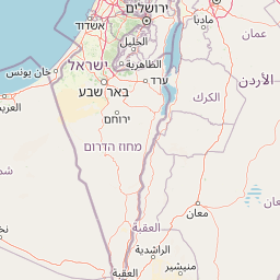
Map view of Wadi Mujib

Use this park location map to pinpoint Wadi Mujib in Jordan, understand its exact geographic position, and read its mapped placement within the surrounding landscape more clearly.

Pigeon | © OpenStreetMap contributors
Park atlas

Compare mapped park geography and diverse protected landscapes across Jordan's Dead Sea region and beyond.

Discover Other National Parks and Protected Areas Near Wadi Mujib in Jordan

Continue your exploration from Wadi Mujib by browsing other national parks and protected areas, tracing their geographic distribution across Jordan's diverse landscapes. Compare these significant conservation areas, discover similar canyon environments, and understand the wider regional protected-area context through mapped terrain and structured park facts.
Watercolor illustration of a landscape with green vegetation, a river, and distant hills under a pale sky
Nature reserveIsrael
About 17 km away#1 closest

West

Ein Gedi Nature Reserve: Protected Area Exploration and Regional Geography in Israel

Mapped natural terrain and protected landscape context.

Ein Gedi Nature Reserve represents a distinct natural area offering specific geographic discovery. Users can explore its mapped boundaries, understand its unique landscape character, and appreciate its protected status within the diverse terrain of Israel. This page serves as a gateway to understanding the reserve's ecological and geographic significance, providing structured data for those interested in the mapped context of protected lands.

Area
14 km²
Established
1971
Visitors
1M annual
Relief
Lowland
National parkIsrael
About 27 km away#2 closest

Southwest

Masada National Park: Explore Israel's Iconic Protected Desert Fortress and Landscape

Discover mapped boundaries and archaeological significance in the Judean Desert.

Masada National Park preserves a remarkable historical fortress and palace complex set within the dramatic desert terrain of Israel's Judean Desert. This protected area is renowned for its archaeological importance, showcasing sophisticated ancient engineering and its role as the final stronghold of the Jewish revolt. The stark, beautiful landscape surrounding the plateau offers significant geographic context, allowing for an atlas-style exploration of its terrain, mapped boundaries, and the wider Dead Sea region.

IUCN
V
Scope
Terrestrial
Water
Minor water
Season
Year-round
Watercolor painting of a landscape with mountains, water, and vegetation
National parkIsrael
About 32 km away#3 closest

North

Qumran National Park: National Park Atlas Exploration and Geographic Context in Israel

Mapped terrain and protected landscape identity in Israel.

Delve into Qumran National Park, a significant national park situated in Israel. This detailed exploration focuses on its protected landscape identity, mapped boundaries, and its place within the country's diverse geography. Understand the unique natural context and regional significance of Qumran National Park through an atlas-driven perspective.

Relief
Lowland
Climate
Arid
Access
Moderate access
Scope
Terrestrial
National parkIsrael
About 39 km away#4 closest

Northwest

Herodion National Park: A Key National Park within Israel's Protected Landscape Atlas

Explore its mapped boundaries and geographic terrain.

Herodion National Park stands as a significant protected area within Israel, contributing vital context to the nation's atlas of natural landscapes. This national park designation highlights its role in conservation and offers a unique opportunity to study its specific geography, terrain, and mapped boundaries. By focusing on the park's protected landscape identity, users can gain structured insights into Israel's conservation efforts and regional geographic features, enhancing any atlas exploration.

Scope
Terrestrial
National parkIsrael
About 41 km away#5 closest

North

Qasr el Yahud National Park: Exploring Protected Landscape and Geographic Identity in Israel

Mapped boundaries and regional natural landscape context.

Qasr el Yahud National Park is a designated protected area in Israel, serving as a crucial site for understanding regional geography and landscape context. This page facilitates detailed exploration of its protected land identity, mapped geographic boundaries, and its place within the natural terrain of the area, offering users a clear view of its atlas significance.

National parkIsrael
About 47 km away#6 closest

Southwest

Tel Arad National Park: Discover Israel's Protected Landscape and Mapped Geography

Explore protected area boundaries and regional terrain context.

Delve into Tel Arad National Park, a key protected area in Israel offering insights into its unique landscape and geographic setting. This park provides a focal point for understanding protected land distribution, mapped terrain features, and the regional natural context within the Levant. Utilize this atlas entry to explore the park's specific geographic identity and conservation significance.

Nature reserveJordan
About 50 km away#7 closest

South

Fifa Nature Reserve Nature Reserve: Protected Landscape Discovery in Jordan

Mapped natural terrain and protected area context.

Fifa Nature Reserve represents a distinct protected natural landscape within Jordan. This entry offers users a detailed atlas-style view of the reserve's protected boundaries and its place within the country's geography. Explore the mapped terrain and understand the significance of this nature reserve for structured geographic discovery and protected-area research.

Area
23.2 km²
Established
2011
Relief
Lowland
Climate
Arid
National parkIsrael
About 55 km away#8 closest

Northwest

Castel National Park: A National Park for Geographic Discovery in Israel

Investigate the mapped protected landscape and regional terrain.

Castel National Park represents a key protected area within Israel, focusing on the discovery of its mapped terrain and geographic identity. As a national park, it serves as a crucial entity for understanding regional conservation landscapes and the distribution of protected areas across Israel. This detailed view allows for focused exploration of the park's boundaries and its contribution to the country's natural heritage, offering valuable context for atlas-based geographical inquiry.

Relief
Mountain
Climate
Mediterranean
Scope
Terrestrial
Water
No major water

Common questions about visiting, size, designation, and location context for Wadi Mujib

Wadi Mujib FAQs for park facts, access, geography, and protected area context

Find quick answers about Wadi Mujib, including protected-area facts, park geography, trail and visitor context, and how the park fits into its surrounding country and regional landscape.
MoriAtlas Explorer

Continue Your Protected Areas Search Across the Global Atlas

Deepen your exploration by continuing the structured search for national parks and protected areas worldwide. Utilize the comprehensive filtering capabilities to compare different conservation landscapes and refine your understanding of global park geography. Discover more about the distribution and characteristics of protected natural areas.

Global natural geography