Mori Atlas logo
Nature reserveWendesser Moor

Analyzing the mapped boundaries, fen habitats, and peatland terrain within the Peine district landscape

Wendesser Moor Nature Reserve: A Detailed Geographic Atlas of Protected Wetland Landscapes in Lower Saxony

(Naturschutzgebiet Wendesser Moor)

Wendesser Moor serves as a vital protected nature reserve in Lower Saxony, Germany, representing a compact yet ecologically dense wetland mosaic. The area features a complex arrangement of peat pools, reed beds, and willow swamp scrub, all situated within a shallow valley landscape of the North German Plain. This authoritative atlas entry outlines the reserve's protected status as an EU Bird Protection Area, its hydrologic connection to the Schwarzwasser stream, and its significance as a marsh bird sanctuary amidst intensive agricultural surroundings.

wetlandmoorfenraised bog remnantreed bedsmarsh birds

Wendesser Moor

Nature reserve

Park overview

Structured park overview, official facts, and landscape profile for Wendesser Moor

Wendesser Moor park facts, protected area profile, and essential visitor context

Review the core facts for Wendesser Moor, including designation, size, terrain, visitor scale, habitats, and operating context in one park-focused overview.

About Wendesser Moor

Wendesser Moor is a small but ecologically valuable nature reserve in the Peine district of Lower Saxony, situated north of the city of Peine on the gently undulating plain of northern Germany. Its roughly 63 hectares protect a varied mosaic of wetland and mire habitats that have persisted within a working agricultural landscape, and the reserve serves as an important example of how localized peatland sites can retain strong conservation significance even when surrounded by farmland and oil extraction areas.

Geographically, the reserve sits at low elevation, between approximately 64 and 66 meters above sea level, in a shallow lowland valley system that drains toward the Schwarzwasser, a small right-bank tributary of the Fuhse river. The terrain is flat to gently sloping, with peat-forming soils that historically supported the development of both lowland fens and the early stages of raised bog formation in the western part of the site.

Ecologically, the reserve is remarkable for its habitat diversity relative to its size. Its central zones include peat ponds fringed by reeds, reed canary grass and sedge communities, flooded grassland, purple moor grass and cotton grass mats, and willow-dominated swamp thickets, along with remnants of alder carr woodland. Tall herb vegetation and moor heath communities also occur. Some of the fen surfaces are still managed as grassland, creating a mix of actively used and more natural wet habitats.

A defining feature of Wendesser Moor is its status as a key refuge for several highly threatened marsh-nesting and wetland-dependent bird species, which has led to its full inclusion in the EU Birds Directive network of protected sites. Although the reserve is bordered to the east by oil-producing fields and to the north, west, and south by intensively cultivated arable land, the protected core of the moor continues to provide a stable environment for sensitive bird populations and characteristic mire vegetation communities.

Quick facts and research context for Wendesser Moor

Wendesser Moor is a designated nature reserve (Naturschutzgebiet) located north of the city of Peine in Lower Saxony, northern Germany. It covers approximately 63 hectares of low-lying fen and transitional mire terrain at elevations of roughly 64 to 66 meters above sea level.

The site has been protected under Lower Saxon nature conservation law since the early 1970s and is administered by the Peine district as the responsible lower nature conservation authority, with broader oversight provided by the Lower Saxony State Agency for Water Management, Coastal Defence, and Nature Conservation (NLWKN). Internationally, it is recognized as an IUCN Category IV habitat and species management area and is fully integrated into a corresponding EU Bird Protection Area.

Protection and recognition

Documented terrestrial protection scope, management records, and Natura 2000 data

Wendesser Moor Protection Status and International Recognition Details

Territorial protection status for Wendesser Moor encompasses recorded management scopes and official Natura 2000 designations. Documented recognition sources establish administrative boundaries and international framework records for this protected area.

International recognition

Protection details

Protection scope
Terrestrial
Transboundary protection
No
WDPA ID
82895
Park context

Deeper park guide and search-rich context for Wendesser Moor

Wendesser Moor history, landscape, wildlife, and travel context

Explore Wendesser Moor through its history, landscape character, ecosystems, wildlife, conservation priorities, cultural context, and seasonal travel timing in a structured park guide built for atlas discovery and search intent.

Why Wendesser Moor stands out

Wendesser Moor is especially known as a small but ecologically dense wetland refuge for threatened marsh birds within an otherwise intensively cultivated agricultural landscape. The reserve combines shallow peat pools with reed beds, sedge communities, and willow swamp scrub, producing the habitat complexity that supports species such as spotted crake, little crake, water rail, and red-necked grebe. Its location within a broader landscape protection zone that adjoins other wet habitats such as the Blumenhagener Moor and Schwarzwasserniederung also makes it a recognized part of a chain of connected mire and meadow sites in the Peine district. For visitors interested in mire ecology and marsh bird conservation in lowland Germany, Wendesser Moor is a representative example of how small peatland reserves retain meaningful biodiversity value.
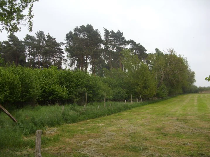
A wide view of a grassy field bordered by a dense line of trees and shrubs in the Wendesser Moor nature reserve under an overcast sky.
A view of the edge of the Wendesser Moor nature reserve in Lower Saxony, Germany.

Wendesser Moor history and protected-area timeline

Wendesser Moor has been formally protected as a nature reserve (Naturschutzgebiet) in Lower Saxony since the early 1970s, with its designation dated to February 1973. The reserve designation was established under the framework of Lower Saxon nature conservation law to safeguard the area's fen, transitional mire, and wetland habitats from further alteration amid increasing agricultural pressure in the surrounding region.

Over time, the reserve's importance was reinforced through its integration into the European network of Bird Protection Areas under the EU Birds Directive, giving the site international recognition for its role in protecting threatened marsh birds. It has also been embedded within a broader landscape protection area that connects it with adjacent wet lowland sites such as the Blumenhagener Moor, Schwarzwasserniederung, and the Staatsforst Peine, framing the moor as one element in a wider network of protected peatland and floodplain habitats in the Peine district.

Throughout its protected history, the site has remained under the supervision of the Peine district as the responsible lower nature conservation authority, with technical and administrative support provided by NLWKN, the Lower Saxony State Agency for Water Management, Coastal Defence, and Nature Conservation.

Wendesser Moor landscape and geographic character

The landscape of Wendesser Moor is defined by the gentle, low-relief character of the North German Plain. The reserve lies within a shallow, formerly poorly drained valley depression that has favored the accumulation of peat-forming sediments and the persistence of wetland conditions even today. Elevations are modest, between about 64 and 66 meters above sea level, and most of the terrain is flat or only slightly undulating.

In the western part of the reserve, a shallow valley form once held no natural outlet, and within this basin peat formation advanced far enough to produce early, localized raised bog development on top of underlying fen peat. The eastern and central parts of the reserve show a more typical fen character, with wet grassland managed for hay and pasture alongside more natural peatland vegetation.

The reserve's setting in the landscape is strongly shaped by surrounding land use. To the east, additional grassland parcels give way to oil extraction fields with their characteristic infrastructure, while to the north, west, and south, intensively cultivated arable fields form a sharp contrast with the wet core of the reserve. The hydrology of the system is tied to the Schwarzwasser stream, a right-bank tributary of the Fuhse, which receives drainage from the moor and connects it into the wider local watercourse network.

Wendesser Moor ecosystems, habitats, and plant life

Wendesser Moor is ecologically defined by its fen and transitional mire vegetation, set within an outer landscape dominated by farmland and oil production fields. The central part of the reserve contains a network of peat pools edged with reeds, reed canary grass stands, and true sedge communities, while the broader surface is composed of wet grassland, flooded meadow communities, purple moor grass mats, and cotton sgrass lawns typical of nutrient-poor peatland conditions.

A distinctive layer of the habitat mosaic comes from shrub and woodland communities that fringe the open wetland areas. Willow-dominated swamp thickets occupy the wettest and most waterlogged zones, while in slightly elevated or more stable positions, fragments of alder-rich swamp forest (Bruchwald) provide a more wooded habitat type. Tall herb communities and moor heath vegetation add to the diversity, supporting invertebrates and the birds that depend on them.

The mix of open water, emergent vegetation, wet grassland, scrub, and woodland patches produces a fine-scale habitat mosaic that contrasts strongly with the surrounding intensively used arable and pasture land. This mosaic is the ecological foundation for the reserve's importance to wetland wildlife, and it is a key reason why the site retains ecological value despite its compact size.

Wendesser Moor wildlife and species highlights

Wendesser Moor is most significant for its bird fauna, especially the community of marsh-nesting and water-dependent species that depend on the mosaic of reed beds, sedge stands, and open peat pools within the reserve. It is recognized as an important refuge for several highly threatened European bird species, including spotted crake, little crake, water rail, and red-necked grebe.

The combination of dense emergent vegetation along the peat ponds, along with flooded meadow, swamp willow scrub, and remnants of alder swamp forest, provides shelter, foraging habitat, and nesting cover for these and other wetland birds. The surrounding wet grassland and the larger landscape protection zone open up additional foraging opportunities, while the enclosed pool and reed habitats offer secure breeding sites within a landscape otherwise dominated by agricultural fields.

Beyond its bird interest, the reserve's structural diversity, including wet meadows, tall herb fringes, moor heath patches, and scrub, supports a wide range of invertebrates and likely supports amphibians and small mammals typical of Central European fen habitats. The site's full integration into an EU Birds Directive area reflects the importance of these bird communities for European conservation targets.

Wendesser Moor conservation status and protection priorities

Wendesser Moor is protected as a designated nature reserve under Lower Saxon law and is formally classified as an IUCN Category IV habitat and species management area, reflecting its role in actively conserving specific habitats and species rather than simply allowing natural processes.

Its broad conservation significance is anchored in its full inclusion in a corresponding EU Bird Protection Area under the European Birds Directive, which highlights its importance as nesting and resting habitat for threatened marsh birds such as spotted crake, little crake, water rail, and red-necked grebe. The reserve is also almost entirely embedded within a larger landscape protection district (Landschaftsschutzgebiet) that connects it to neighboring peatland and floodplain sites, helping maintain wider functional habitat networks in the Peine district.

Conservation management of the site combines strict protection of its core wetland habitats with low-intensity grassland use on selected fen surfaces. Because the reserve is surrounded by intensive agriculture and oil production activity, the protected core serves as a critical refuge for species that would otherwise be excluded from such an intensively used working landscape. This combination of small size, strong legal protection, and connection to broader conservation networks gives Wendesser Moor an outsized role for lowland mire biodiversity in the region.

Wendesser Moor cultural meaning and human context

Wendesser Moor is part of a long-standing cultural landscape of managed peatland and wet meadow in the Peine district, where fen surfaces have historically been mown or grazed as part of the local agricultural economy. The persistence of some peatland areas as open grassland reflects this heritage of low-intensity wetland farming that continues to shape the reserve today.

The presence of historical peat areas and the surrounding fields points to a regional identity in which peat harvest, wet meadow use, and lowland farming have coexisted with mire vegetation. The inclusion of Wendesser Moor within a large landscape protection district, alongside named neighboring moors such as Blumenhagener Moor and the Schwarzwasserniederung, reflects the region's recognition of these peatland landscapes as part of the cultural and natural heritage of the Peine area.

Top sights and standout views in Wendesser Moor

Wendesser Moor stands out for combining a remarkably diverse peatland habitat mosaic with an exceptionally strong importance for threatened marsh birds, despite its compact size.

Key qualities that define the reserve include its peat pools edged with reeds and sedge communities, its willow swamp thickets and remnants of alder carr, its full integration into an EU Bird Protection Area, and its position at the heart of a wider landscape protection zone linking multiple peatland and meadow sites in the Peine district. Together these features make the reserve both a representative example of northern German lowland mire conservation and a meaningful refuge for species that have disappeared from much of the surrounding agricultural landscape.

Best time to visit Wendesser Moor

Wendesser Moor is most rewarding to visit during the warmer months of late spring and summer, when wetland vegetation is in full growth, the reed beds and sedge mats are most visible, and marsh-nesting birds are actively present on the reserve's peat pools and wet meadows.

Late spring typically brings the most active bird displays and vocal activity from species such as spotted crake, little crake, water rail, and red-necked grebe, while summer offers the fullest expression of the mire's vegetation cover and insect life. Early morning or evening visits during this period generally offer the best chances of observing wetland wildlife, since the fen habitats are quiet, the surrounding agricultural land limits visitor pressure, and the flat, low-lying terrain is easiest to read under softer light.


Monthly climate preview

Long term temperature curves and precipitation patterns measured at representative coordinates

Wendesser Moor Climate Normals, Average Temperature and Monthly Precipitation Records

Representative coordinate records show measured monthly temperature ranges and precipitation rates spanning the annual cycle at Wendesser Moor. Detailed month by month climate normals provide complete statistical context for evaluating long term environmental conditions across the terrain.
Annual mean9 °C
0 °C19 °C
Jan
Feb
Mar
Apr
May13°
Jun16°
Jul19°
Aug18°
Sep14°
Oct
Nov
Dec
Warmest month
July

18.5 °C

Coolest month
January

0.4 °C

Wettest month
July

2.5 mm/day

Driest month
April

1.4 mm/day

Park location guide

Geography guide, regional context, and park location map for Wendesser Moor

Wendesser Moor park geography, regions, and map view in Germany

Understand where Wendesser Moor sits in Germany through a broader geographic reading of the surrounding landscape, nearby location context, and its mapped position within the national park landscape.

How Wendesser Moor fits into Germany

Germany is a federal republic in Western and Central Europe with a population of over 83 million across sixteen constituent states. It is Europe's largest economy by nominal GDP and a major global exporter and importer. The capital is Berlin, and the country borders Denmark, Poland, Czech Republic, Austria, Switzerland, France, Luxembourg, Belgium, and the Netherlands.

Wider geography shaping Wendesser Moor in Germany

Germany is located in Western and Central Europe, spanning 357,022 km². It borders Denmark to the north, Poland and the Czech Republic to the east, Austria and Switzerland to the south, and France, Luxembourg, Belgium, and the Netherlands to the west. The country has coastlines on the Baltic Sea and North Sea to the north, with the Alps located in the southern region.

Map view of Wendesser Moor

Use this park location map to pinpoint Wendesser Moor in Germany, understand its exact geographic position, and read its mapped placement within the surrounding landscape more clearly.

Pigeon | © OpenStreetMap contributors

Location context for Wendesser Moor

Lower Saxony

Visual exploration of fen habitats, peat pools, and marsh bird refuges in lowland Germany

Wendesser Moor Landscape Photos and Protected Wetland Scenery

Visual documentation captures the unique wetland terrain, shallow peat pools, and diverse mire habitats characterizing Wendesser Moor. Examining these protected area photographs reveals the ecological complexity and landscape character defining this lowland nature reserve.

A wide view of a grassy field bordered by a dense line of trees and shrubs in the Wendesser Moor nature reserve under an overcast sky.

Park atlas

Compare nearby wetland reserves and connected lowland mire habitats in Lower Saxony

Explore Parks Near Wendesser Moor and Surrounding Protected Landscapes

Browse other parks and protected areas near Wendesser Moor to examine related wetland habitats across the North German Plain. Extending the geographic review connects individual fen reserves into a wider network of regional conservation landscapes.
Nature reserveLower Saxony
About 18 km away#1 closest

Northeast

Viehmoor Nature Reserve: A Detailed Atlas of Wetland and Dune Landscapes in Lower Saxony

Protected lowlands, inland dunes, and riparian habitats

Viehmoor is a distinct 302-hectare protected area in Lower Saxony defined by its glacial history and diverse habitat transitions. The site features an inland dune ridge encircling a groundwater-fed lowland mire, alongside varied aquatic environments including reed-fringed fishponds and peat-cutting pools that provide vital breeding grounds for regional bird populations.

Area
3.02 km²
Established
1979
IUCN
IV
Nature reserveHildesheim District
About 19 km away#2 closest

Southwest

Wätzumer Tonkuhle Nature Reserve: Geography and Protected Boundaries in Hildesheim District

A restored wetland refuge in the Lower Saxony agricultural landscape

Wätzumer Tonkuhle offers a rare glimpse into secondary wetland succession within the Hildesheim District. This nature reserve features two primary ponds and an extensive fallow corridor along the Alpebach, serving as a critical sanctuary amidst the surrounding intensive farmland of Northern Germany.

Area
0.105 km²
Established
1986
IUCN
IV
A minimalist watercolor painting featuring soft green, yellow, and purple tones depicting a rolling hill landscape with trees and distant hills.
Nature reserveNiedersachsen
27 km away#3 closest

Southwest

Haseder Busch, Giesener Berge, Gallberg, Finkenberg Protected Landscape and Map Data

A diverse hill and floodplain ecosystem in Niedersachsen, Germany.

Trace the ecological boundaries and terrain of this expansive nature reserve. The site features a rare convergence of Triassic sedimentary landscapes, including the northernmost calcareous semi-dry grasslands and beech forests in the region, alongside historic floodplain meadows shaped by the Innerste river.

Area
7.42 km²
Established
2019
A soft watercolor illustration of a river winding through a green floodplain with rolling hills in the background.
Nature reserveRegion Hannover
27 km away#4 closest

West

Leineaue zwischen Hannover und Ruthe: Protected Floodplain and River Geography

Nature reserve geography and alluvial habitat mapping.

Examine the topographic and hydrological features of the Leineaue zwischen Hannover und Ruthe nature reserve. This atlas entry provides insights into the site's dual-channel river structure, calcareous tufa springs, and fragmented alluvial woodlands that define this significant conservation area near Hannover.

Area
9.678 km²
Established
2007
Relief
Lowland
Scope
Terrestrial
Nature reserveSalzgitter
About 28 km away#5 closest

South

Tagebau Haverlahwiese Nature Reserve: Geography and Protected Area Mapping in Salzgitter

Mapping restored post-industrial landscapes and habitat mosaics.

This protected area in Salzgitter showcases the natural recovery of former ironstone mining lands. Users can examine the spatial arrangement of the 15-hectare mining lake, extensive reedbeds, and dry calcareous grassland slopes. The site remains a vital example of landscape conservation, illustrating how engineered topography provides new niches for amphibians and salt-tolerant plant communities across the Lichtenberge ridge.

Area
2.06 km²
Established
2016
Relief
Upland
Climate
Temperate
Protected landscapeLower Saxony
About 29 km away#6 closest

East

Weddeler Teich Protected Landscape: Wetland Geography and Regional Map Context

A mapped nature reserve in the Lower Saxony lowlands

Weddeler Teich is a protected landscape in Lower Saxony characterized by its shallow, nutrient-rich basin and extensive reed vegetation. This wetland reserve acts as a critical refuge for bird species, standing out as a verdant marshy pocket within the wider cultivated agricultural plains east of Braunschweig.

Area
0.2 km²
Established
1981
Relief
Lowland
Climate
Temperate
Nature reserveWolfenbuettel
About 29 km away#7 closest

South

Steinbruch Baddeckenstedt Nature Reserve: Protected Limestone Landscape in the Wolfenbuettel District

A restored former quarry environment with rich fossil deposits

Steinbruch Baddeckenstedt protects a six-hectare area of limestone cliffs and calcareous rubble slopes within the Wolfenbuettel district. This former quarry offers a specialized habitat for rare plants and wildlife, providing a vital example of post-industrial land conservation and geological exposure in central Germany.

Area
0.063 km²
Established
2009
IUCN
IV
Relief
Upland
Nature reserveRegion Hannover
About 32 km away#8 closest

West

Sundern Nature Reserve and Floodplain Forest Landscapes of Region Hannover

Historic river meander and alluvial habitat preservation

Sundern represents a critical fragment of the historic Leine river floodplain in the Region Hannover. This nature reserve features a complex mosaic of moist backwaters and dry deciduous woodlands, including old-growth oak-hornbeam stands. The area is defined by its glacial valley setting, where centuries of sediment accumulation have shaped a distinct, slightly elevated landscape mosaic that remains vital for regional conservation.

Area
0.504 km²
Established
1931
IUCN
IV
Relief
Lowland

Common questions about visiting, size, designation, and location context for Wendesser Moor

Wendesser Moor FAQs for park facts, access, geography, and protected area context

Find quick answers about Wendesser Moor, including protected-area facts, park geography, trail and visitor context, and how the park fits into its surrounding country and regional landscape.
MoriAtlas Explorer

Continue Your Protected Areas Search Across the Global Atlas

Deepen your exploration by continuing the structured search for national parks and protected areas worldwide. Utilize the comprehensive filtering capabilities to compare different conservation landscapes and refine your understanding of global park geography. Discover more about the distribution and characteristics of protected natural areas.

Global natural geography