
Mori Atlas logo
State or regional parkWestern Sydney Parklands

Mapping the linear corridors and ecological precincts of this New South Wales landmark

Western Sydney Parklands: A Comprehensive Geographic Profile of the Urban Nature Reserve

Western Sydney Parklands functions as a primary metropolitan green corridor in New South Wales, spanning approximately 27 kilometres along an elongated north-south axis. This protected area incorporates critical remnants of Cumberland Plain Woodland alongside extensive re-vegetation projects, forming a complex hydrological crossroads between multiple river catchments. Visitors and researchers can utilize this geographic data to understand the park's ridgeline terrain, wetland distribution, and its unique role as a connected ecosystem within a major Australian urban centre.

urban parknature reserveCumberland Plain Woodlandwoodlandgrasslandwetland
An illustration showing a waterfall flowing over a cliff into a valley surrounded by gum trees and native grasses.

Western Sydney Parklands

State or regional park

Park overview

Structured park overview, official facts, and landscape profile for Western Sydney Parklands

Western Sydney Parklands park facts, protected area profile, and essential visitor context

Review the core facts for Western Sydney Parklands, including designation, size, terrain, visitor scale, habitats, and operating context in one park-focused overview.

About Western Sydney Parklands

Western Sydney Parklands occupies a remarkable position between urban density and ecological recovery in Greater Western Sydney. Spanning roughly 5,280 hectares across three local government areas, the parklands form an elongated network of linked open spaces, sports grounds, walking tracks, picnic areas, and natural reserves. The park stretches from the northern suburbs around Quakers Hill and Dean Park, through Blacktown, Fairfield, and Cecil Hills, and continues south toward Horningsea Park and Leppington. A prominent north-south ridgeline runs through the park, forming both a scenic backbone and a major catchment divide between the Hawkesbury-Nepean, Georges River, and Parramatta River systems.

Administratively, the parklands sit within a robust conservation framework. They are owned by the Government of New South Wales, governed by the NSW National Parks and Wildlife Service, and operate under the National Parks and Wildlife Act 1974. The Western Sydney Parklands Trust provides on-the-ground management, and the park has received substantial public investment. At the same time, the park holds genuine ecological importance: small remnants of Cumberland Plain Woodland, listed as a critically endangered ecological community, persist alongside large areas of re-vegetation supported through programs such as Greening Western Sydney.

Recreationally, the parklands are highly developed. Sixteen precincts and roughly fifty park areas deliver a mix of experiences, from the off-leash open spaces and wetlands of Bungaribee in the north, to the rugged woodlands and lookouts of Lizard Log and Sugarloaf Ridge in the south. Iconic facilities such as Blacktown Olympic Park, the Sydney International Equestrian Centre, and the Sydney International Shooting Centre reflect the park's role as a venue for major events, including the Sydney 2000 Olympic Games. The combination of formal recreational infrastructure, ecological restoration, and Aboriginal cultural significance gives Western Sydney Parklands a distinctive profile among Australian urban parks.

Quick facts and research context for Western Sydney Parklands

Western Sydney Parklands is an urban park system and nature reserve of about 5,280 hectares, running roughly 27 kilometres from Quakers Hill in the north to Leppington in the south. It is located in Greater Western Sydney and crosses the local government areas of Blacktown, Fairfield, and Liverpool.

The parklands are owned by the Government of New South Wales and administered by the NSW National Parks and Wildlife Service under the National Parks and Wildlife Act 1974, with on-the-ground management provided by the Western Sydney Parklands Trust. The reserve contains roughly 135 hectares of Cumberland Plain Woodland remnants and about 427 hectares of planted vegetation and cleared grassland, supporting native flora, resident kangaroos and fallow deer, and around eighty native vertebrate species.

Protection and recognition

Documented terrestrial protection scope and recognized conservation context

Western Sydney Parklands Protection Status and Designated Area Framework

Western Sydney Parklands maintains a documented terrestrial protection scope within its regional landscape. Comprehensive protected area designation details outline the management framework and associated conservation context.

Protection details

Protection scope
Terrestrial
Transboundary protection
No
Park context

Deeper park guide and search-rich context for Western Sydney Parklands

Western Sydney Parklands history, landscape, wildlife, and travel context

Explore Western Sydney Parklands through its history, landscape character, ecosystems, wildlife, conservation priorities, cultural context, and seasonal travel timing in a structured park guide built for atlas discovery and search intent.

Why Western Sydney Parklands stands out

Western Sydney Parklands is best known for being one of the largest urban park systems of its kind in the world, combining a continuous green corridor of woodlands, grasslands, and recreational precincts across a densely populated metropolitan region. It is prominent for its role in conserving remnants of the critically endangered Cumberland Plain Woodland, reinforced by large-scale re-vegetation efforts such as the planting of more than 140,000 trees by school students in 2019. The park is also recognised for the way it follows and incorporates major transport corridors, particularly the M7 motorway and M7 cycleway, creating an accessible spine of public open space in western Sydney. The long ridgeline that runs through the park, sweeping vistas over Greater Western Sydney, and a string of distinctive precincts ranging from Bungaribee in the north to the southern reserves add to its character.
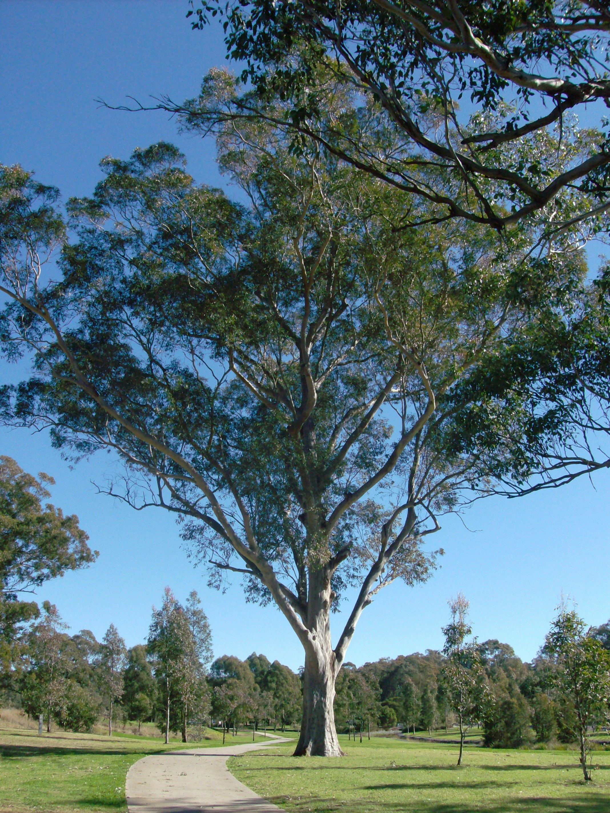
A concrete path curves through a park with a large eucalyptus tree in the foreground and a line of trees in the background under a clear blue sky.
A paved walking path winds through a stand of eucalyptus trees in Western Sydney Parklands.

Western Sydney Parklands history and protected-area timeline

The landscape that would become Western Sydney Parklands has deep Aboriginal heritage. The area was significant to the Darug people and continues to be recognised as important by the Aboriginal Land Council. Early European visitors included figures such as Edward Abbott and George Johnson, and colonial land use left behind sites such as the Upper Canal System and the Bungarribee Homestead archaeological complex.

The modern park was formally planned in 1968, when planners responded to the growing recreational needs of Western Sydney and designated a long corridor of open space. During the late 1970s, parts of the northern regional park were used for rural residential lots near Horsley Park, a legacy of the area's earlier semi-rural character. The park's modern identity took shape around the turn of the millennium when it provided venues for the Sydney 2000 Olympic Games, supplying important sporting and event infrastructure that continues to be part of the parklands today.

The boundaries of the park were finalised in 2006, and a year later, a continuous walking and cycling track winding through the reserve was completed and opened to the public, transforming the park into a more accessible and unified green corridor. Since then, ecological restoration has become a defining theme, culminating in major community-led efforts such as the 2019 campaign in which school students planted over 140,000 trees to rejuvenate the endangered Cumberland Plain Woodland community.

Western Sydney Parklands landscape and geographic character

Western Sydney Parklands is shaped around a distinctive elongated footprint that mirrors the alignment of major transport corridors in western Sydney. From north to south, the park follows the western side of the M7 motorway and the M7 cycleway, crossing to the western side near Cecil Hills before terminating in Horningsea Park. This linear layout gives the park a corridor-like character, narrow east to west but unusually long, covering roughly 27 kilometres from Quakers Hill to Leppington.

The most prominent physical feature is a continuous north-south ridgeline that traverses the reserve, offering sweeping panoramic views across Greater Western Sydney. Soils across the park are dominated by Luddenham soil derived from Wianamatta Shale, supporting both remnant and planted vegetation. Wetland pockets, such as those around Bungaribee, contrast with drier ridgeline views from points like Moonrise Lookout and Sugarloaf Ridge.

The parkland also functions as a hydrological crossroads. It contains the headwaters of Eastern Creek, a tributary of the Hawkesbury-Nepean system, and sits along the catchment boundary that separates the Hawkesbury-Nepean, Georges River, and Parramatta River basins. The landscape thus combines scenic ridge lines, seasonal wetlands, open grasslands, and woodland remnants within a connected metropolitan green space.
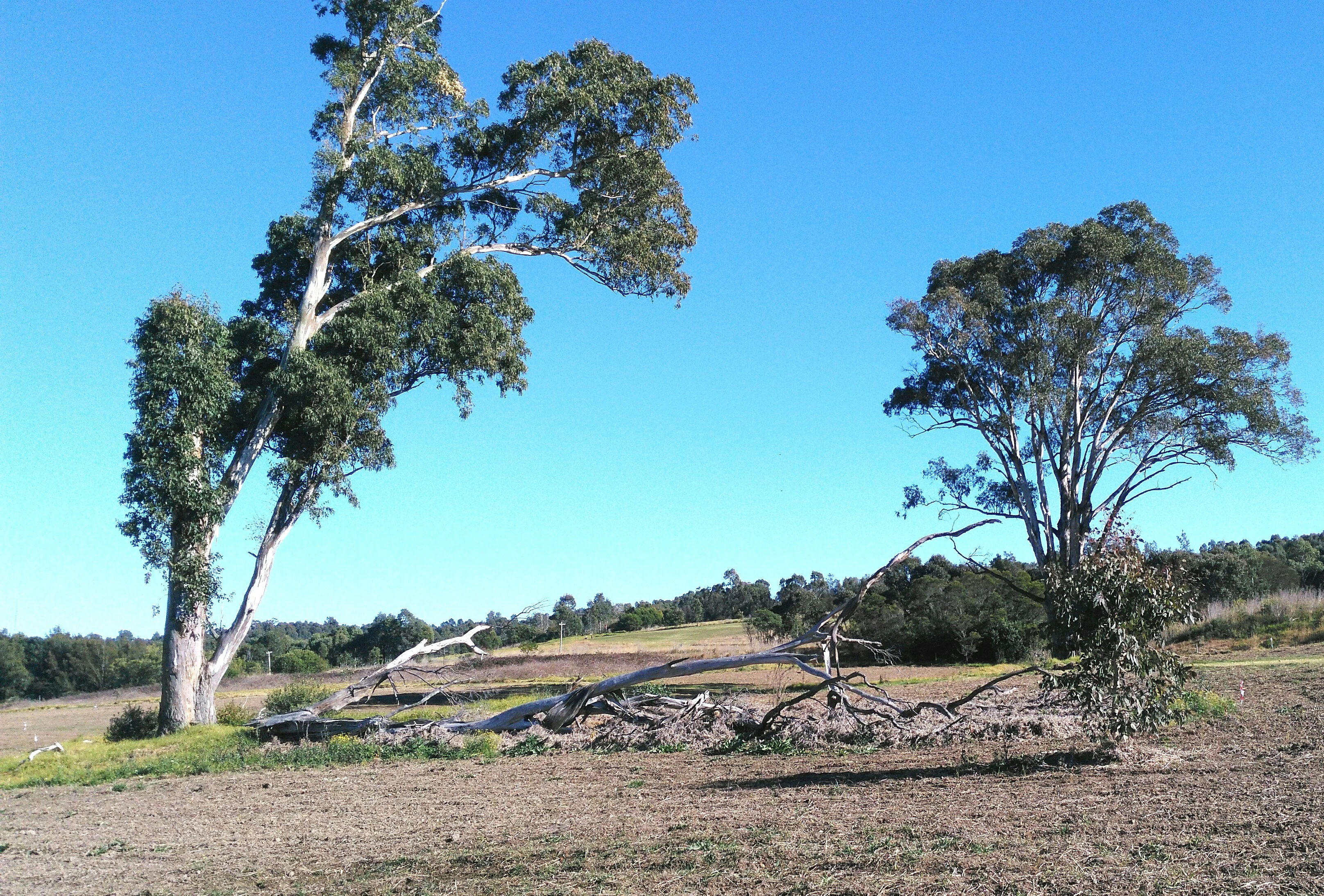
A wide view of an open field with sparse vegetation, featuring two large eucalyptus trees and a fallen tree trunk in the foreground, under a clear blue sky.
Open landscape with mature eucalyptus trees in Western Sydney Parklands.

Western Sydney Parklands ecosystems, habitats, and plant life

Ecologically, Western Sydney Parklands occupies a precarious but important position, preserving fragments of one of Sydney's most threatened vegetation types while actively rebuilding what has been lost. The park contains roughly 135 hectares of Cumberland Plain Woodland, a critically endangered ecological community that once dominated much of the Sydney region. Around 427 hectares consist of planted re-vegetation and cleared grassland, the result of decades of restoration work supported through programs such as Greening Western Sydney, which has been active since the early 1990s.

Tree species across the park include forest red gum, Eucalyptus moluccana, Eucalyptus tereticornis, Eucalyptus crebra, Corymbia maculata, stringybark species, and Eucalyptus eugenioides. The shrub and ground layer includes blackthorn (Bursaria spinosa), Themeda triandra, Themeda australis, and Microlaena stipoides, helping maintain a savanna-style landscape in areas such as Bungaribee. Wetland pockets within the park support wildflowers and provide habitat diversity not found in the surrounding suburbs.

The park's vegetation mosaic supports around eighty native vertebrate species, including mammals, birds, reptiles, amphibians, and bats. Although foxes and rabbits are present and not rare, the broader ecological character of Western Sydney Parklands is shaped by its role as habitat, by its long corridors of connected bushland, and by the restoration efforts that continue to expand the extent of native vegetation across the reserve.
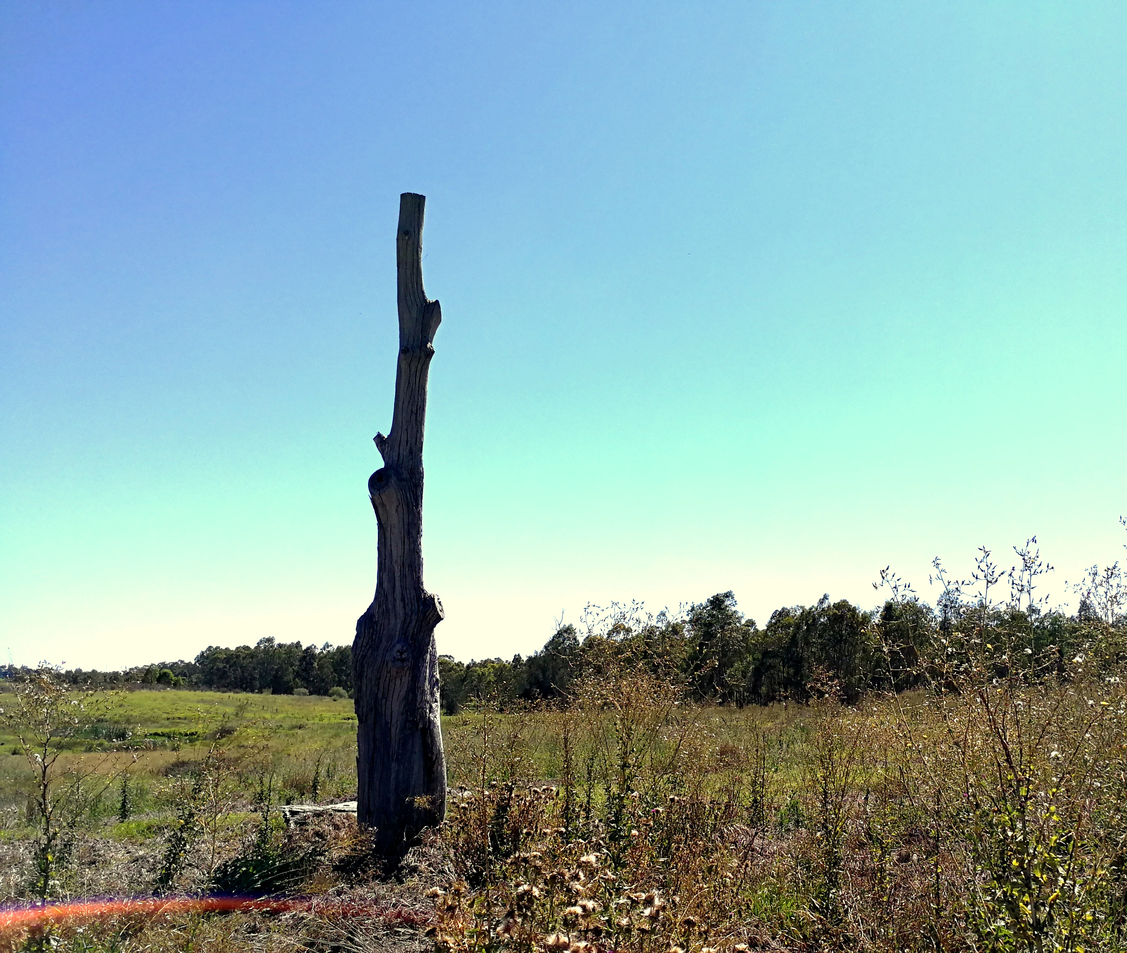
A dead, standing tree trunk rises from a field of dry grass and low shrubs under a clear blue sky in Western Sydney Parklands.
A weathered tree snag standing in the open grasslands of Western Sydney Parklands.

Western Sydney Parklands wildlife and species highlights

Western Sydney Parklands hosts a broad cross-section of native fauna, from large mammals to migratory birds and a characteristic range of parrots. The northern sections around Quakers Hill, Glendenning, and Bungarribee are particularly notable for a substantial population of eastern grey kangaroos, and the park also supports a sizeable population of fallow deer. Native frogs, lizards, and bats are common across a range of habitats, and the park's owls and bats include species such as the eastern false pipistrelle, common bent-wing bat, east-coast free-tailed bat, and Rüppell's broad-nosed bat.

Birdlife is one of the most visible elements of the park's fauna. Parrots, including rainbow lorikeets, rosellas, red-rumped parrots, galahs, and cockatoos, are present year round across the park's trees, while migratory species also pass through the reserve. Threatened bird species such as the white-faced heron, little eagle, varied sittella, and turquoise parrot are recorded within the parklands.

The park supports threatened species across several animal groups. Protection is afforded under both state and Commonwealth legislation, and notable records include the snail Meridolum corneovirens, arboreal marsupials such as the brush-tailed phascogale and several Petaurus species, and the grey-headed flying fox. The combination of woodland remnants, wetlands, and grasslands provides year-round habitat as well as stopover resources for migratory birds.

Western Sydney Parklands conservation status and protection priorities

Conservation is central to the identity of Western Sydney Parklands, both in its formal listing and in its on-the-ground programs. The parklands are administered under the National Parks and Wildlife Act 1974, giving them a recognised legal status that supports protection of native flora and fauna, including species listed as threatened under state and Commonwealth legislation. The presence of Cumberland Plain Woodland, a critically endangered Sydney ecological community, gives the park a particularly high conservation profile.

Restoration has been a key theme for decades. Through the Greening Western Sydney Program and ongoing revegetation efforts active since the early 1990s, large areas of former cleared grassland have been converted back to vegetation, with more than 140,000 trees planted by school students alone in 2019 to rejuvenate endangered woodland. The combination of remnant bushland and active planting is intended to rebuild habitat connectivity across the park's long corridor.

The park also serves conservation by buffering remnant habitats from surrounding urban development, by maintaining a north-south ecological corridor that supports wildlife movement, and by conserving catchment values at the headwaters of Eastern Creek and along the Hawkesbury-Nepean, Georges River, and Parramatta River catchments. Together, these features make Western Sydney Parklands an important component of regional biodiversity conservation in western Sydney.

Western Sydney Parklands cultural meaning and human context

Western Sydney Parklands carries a layered cultural history that stretches back well before its formal establishment as a regional park. The land has longstanding significance to the Darug people, and contemporary Aboriginal heritage remains an active dimension of the reserve, with the Aboriginal Land Council continuing to recognise the area as important. Indigenous connections are part of the park's identity alongside its colonial-era history.

European settlement also left deep marks on the landscape. Early explorers and settlers such as Edward Abbott and George Johnson passed through the area, and pastoral and military uses shaped parts of the parklands. Heritage sites still present include the Upper Canal System and the archaeological remains of the Bungarribee Homestead complex, alongside former military and infrastructural places such as market gardens, easements, and water supply canals.

In the modern era, the parklands have acquired a new layer of cultural meaning through their role in the Sydney 2000 Olympic Games, which located major venues on parkland, and through ongoing community engagement, particularly through tree-planting campaigns and recreational use by residents of Blacktown, Fairfield, and Liverpool.

Top sights and standout views in Western Sydney Parklands

Western Sydney Parklands stands out for its sheer scale within a major metropolitan area, linking sixteen precincts and around fifty park areas along a 27-kilometre corridor. The park's mix of Cumberland Plain Woodland remnants, large-scale re-vegetation, and rugged ridgeline scenery makes it an unusually rich urban nature reserve.

Distinctive attractions include the open spaces and wetlands of Bungaribee, the Chinese garden and lake at Nurragingy Reserve, the woodlands and lookouts around Lizard Log and Sugarloaf Ridge, the heritage values of The Rooty Hill and Upper Canal System, and major sporting venues such as Blacktown Olympic Park and the Sydney International Equestrian Centre. Large populations of eastern grey kangaroos, resident parrots, and migratory birdlife reinforce its appeal as a biodiversity-rich green corridor.

Best time to visit Western Sydney Parklands

Western Sydney Parklands is open throughout the year, and its character shifts with the seasons in ways that suit different kinds of visits. Spring is often the most rewarding period for wildflowers, bird activity, and pleasant walking and cycling conditions, while autumn offers cooler temperatures for longer walks along the ridge and through woodland precincts such as Lizard Log and Bungaribee.

Summer in western Sydney can be hot, and visits are generally more comfortable in the cooler parts of the day, when shaded picnic areas, barbecue spots, and the park's waterways and wetlands become particularly attractive. Winter brings crisper views from the park's north-south ridgeline and is a good time for spotting active kangaroos and a wide range of birdlife, including migratory species returning to or passing through the reserve.

Monthly climate preview

Long-term representative point measurements tracking annual temperature and precipitation rhythm

Western Sydney Parklands Climate Normals, Average Temperature and Monthly Precipitation

Representative coordinate records show average monthly temperatures ranging from eight degrees Celsius in winter to twenty-three degrees Celsius in summer alongside steady daily precipitation values. Examining the complete twelve-month climate profile reveals precise variations in seasonal temperature ranges and precipitation patterns across the protected terrain.
Annual mean16 °C
9 °C23 °C
Jan23°
Feb22°
Mar19°
Apr16°
May12°
Jun10°
Jul
Aug10°
Sep13°
Oct16°
Nov19°
Dec21°
Warmest month
January

22.9 °C

Coolest month
July

8.6 °C

Wettest month
February

4.6 mm/day

Driest month
September

1.9 mm/day

Park location guide

Geography guide, regional context, and park location map for Western Sydney Parklands

Western Sydney Parklands park geography, regions, and map view in Australia

Understand where Western Sydney Parklands sits in Australia through a broader geographic reading of the surrounding landscape, nearby location context, and its mapped position within the national park landscape.

How Western Sydney Parklands fits into Australia

Australia is a constitutional monarchy and federal parliamentary democracy comprising six states and ten territories. With a population of nearly 28 million, it is one of the world's most urbanised countries, with most people concentrated on the eastern seaboard. The country has a high Human Development Index and is known for its cultural diversity, ancient Aboriginal heritage, and unique wildlife.

Wider geography shaping Western Sydney Parklands in Australia

Australia occupies the entire Australian continent, the island of Tasmania, and numerous smaller islands. It is the world's flattest and driest inhabited continent, featuring vast deserts in the interior (the Outback), tropical rainforests along the eastern coast, and a coastline bordering the Indian and Pacific Oceans.

Map view of Western Sydney Parklands

Use this park location map to pinpoint Western Sydney Parklands in Australia, understand its exact geographic position, and read its mapped placement within the surrounding landscape more clearly.

Pigeon | © OpenStreetMap contributors

Location context for Western Sydney Parklands

New South Wales

Explore detailed photographs capturing woodlands, ridges, and conservation habitats across the corridor.

Western Sydney Parklands Photos and Scenery: Visualizing the Protected Urban Landscape

Visual documentation reveals the diverse terrain, native woodland remnants, and wetland pockets spanning the protected urban corridor. Examining these field photographs clarifies the complex ecological character and expansive ridgeline geography defining the reserve.

A concrete path curves through a park with a large eucalyptus tree in the foreground and a line of trees in the background under a clear blue sky.

A wide, eye-level view of a dry, grassy field in the Western Sydney Parklands under an overcast sky, with a line of trees in the background.

A wide view of an open field with sparse vegetation, featuring two large eucalyptus trees and a fallen tree trunk in the foreground, under a clear blue sky.

A dead, standing tree trunk rises from a field of dry grass and low shrubs under a clear blue sky in Western Sydney Parklands.

Park atlas

Compare surrounding regional geography, protected landscapes, and connected green corridors

Explore Protected Areas and Parks Near Western Sydney Parklands in New South Wales

Visitors exploring Western Sydney Parklands can browse nearby protected areas and connected green spaces across the surrounding region. Comparing adjacent natural reserves reveals broader regional geography, metropolitan woodland remnants, and diverse conservation landscapes.
Wildlife reserveNew South Wales
About 12 km away#1 closest

Southeast

Chipping Norton Islands Wildlife Reserve: Mapped Landscapes and Geographic Overview

A vital wetland refuge in the Georges River floodplain

The Chipping Norton Islands comprise four distinct islets within a reclaimed lake landscape, serving as a sanctuary for over fifty bird species. This protected reserve illustrates the intersection of human-modified terrain and native ecosystems, featuring fringing mangroves, reed beds, and remnants of alluvial woodland that define this unique western Sydney habitat.

Relief
Lowland
Climate
Temperate
Access
Highly restricted
Scope
Terrestrial
Nature reserveNew South Wales
About 17 km away#2 closest

Northeast

Bidjigal Reserve: Protected Sandstone Landscapes and Cultural History in Sydney

Nature reserve featuring rare forest remnants and creek corridors

Spanning 186 hectares, Bidjigal Reserve acts as an intact bushland enclave within Sydney, New South Wales. The landscape transitions from suburban boundaries into diverse terrain including sandstone-based gullies, ridge formations, and remnants of Blue Gum High Forest. This area provides critical ecological habitat and protects ancient Aboriginal habitation sites, offering a distinct study in urban-adjacent wilderness and geological significance.

Area
1.86 km²
Established
2004
Relief
Lowland
Scope
Terrestrial
National parkNew South Wales
About 20 km away#3 closest

Southeast

Georges River National Park: Protected Landscape and Geographic Context in New South Wales

Mapped terrain, sandstone woodlands, and key wetland habitats.

Georges River National Park, located within New South Wales, Australia, serves as a crucial protected natural area. Its 514 hectares encompass diverse terrain shaped by the Georges River, featuring significant mangrove swamps, salt marshes, and exposed sandstone woodlands characteristic of the Sydney region. This park's atlas value lies in its role preserving vital ecosystems, supporting a notable array of vertebrate and bird species, and showcasing unique natural landscapes easily explored through mapped terrain and geographic context.

Area
5.14 km²
Established
1992
IUCN
II
Relief
Lowland
National parkNew South Wales
About 22 km away#4 closest

Northeast

Berowra Valley National Park: A National Park in New South Wales with Detailed Geographic Mapping

Explore its mapped boundaries and regional landscape context.

Delve into Berowra Valley National Park, a protected area situated in New South Wales, Australia. This entry provides essential geographic context, focusing on its mapped boundaries and the specific natural landscape it encompasses. It serves as a key resource for understanding the park's role within the broader regional atlas and its distinct protected terrain.

Area
38.84 km²
Established
2012
IUCN
II
Relief
Upland
Nature reserveNew South Wales
About 22 km away#5 closest

North

Windsor Downs Nature Reserve: Cumberland Plain Woodland and Protected Area Geography

Mapping western Sydney's vital woodland remnants

Windsor Downs Nature Reserve protects a crucial fragment of endangered Cumberland Plain Woodland within the western Sydney landscape. Covering 364 hectares of rolling terrain, the reserve offers significant value for understanding regional ecological patterns, forest regeneration, and the intersection of conservation land with rapidly expanding urban environments.

Area
3.64 km²
Established
1990
IUCN
Ia
Visitors
10K annual
Watercolor illustration of a river landscape with trees and vegetation
National parkNew South Wales
About 22 km away#6 closest

East

Lane Cove National Park: A Suburban National Park within New South Wales

Mapped bushland, river ecosystems, and diverse vegetation.

Lane Cove National Park presents a remarkable example of protected natural landscape persisting within metropolitan Sydney, New South Wales. This 670-hectare national park preserves varied ecosystems from sclerophyll forest to mangroves along the Lane Cove River. Its geographic position provides a unique atlas context, highlighting urban wilderness and ecological diversity within the Sydney region.

Area
6.7 km²
Established
1938
IUCN
V
Relief
Lowland
A soft watercolor illustration of a river flowing through a grassy valley with scattered trees and distant rolling hills on a white background.
State or regional parkNew South Wales
About 23 km away#7 closest

Southwest

Bents Basin State Conservation Area: A Geographic Atlas of the Nepean River Gorge

Protected river basin and sandstone terrain in New South Wales

Centered on a lagoon-like swimming hole formed by the Nepean River, Bents Basin State Conservation Area represents a critical protected landscape within New South Wales. The reserve showcases a transition between rugged sandstone gorge topography and the undulating shale-based soils of the Cumberland Plain. Examine the mapped boundaries and natural features of this ecologically rich riparian corridor located in the Sydney metropolitan area.

Area
0.62 km²
Established
1980
IUCN
II
Relief
Upland
National parkNew South Wales
About 23 km away#8 closest

South

Georges River Koala National Park: A Protected Landscape for Critical Koala Habitat in New South Wales

Mapped geography and unique wildlife sanctuary.

Georges River Koala National Park represents a key protected area within New South Wales, specifically designated for safeguarding critical koala populations. This national park offers an invaluable insight into the region's undulating woodland terrain and the Georges River corridor's role in providing essential habitat. Understand the park's landscape character, its mapped boundaries, and its importance as a sanctuary for chlamydia-free koala colonies.

Area
18.3 km²
Established
2023
IUCN
II
Relief
Lowland

Common questions about visiting, size, designation, and location context for Western Sydney Parklands

Western Sydney Parklands FAQs for park facts, access, geography, and protected area context

Find quick answers about Western Sydney Parklands, including protected-area facts, park geography, trail and visitor context, and how the park fits into its surrounding country and regional landscape.
MoriAtlas Explorer

Continue Your Protected Areas Search Across the Global Atlas

Deepen your exploration by continuing the structured search for national parks and protected areas worldwide. Utilize the comprehensive filtering capabilities to compare different conservation landscapes and refine your understanding of global park geography. Discover more about the distribution and characteristics of protected natural areas.

Global natural geography