Mori Atlas logo
National parkXuân Thủy National Park

Discover the mapped boundaries and regional geography of this national park.

Xuân Thủy National Park: Vietnam's Protected Landscape in Nam Định Province

Xuân Thủy National Park represents a significant protected area within the geographic context of Nam Định Province, Vietnam. This page offers an atlas-driven exploration of its protected landscape, focusing on its mapped boundaries and the regional terrain. Understand how this national park contributes to the broader conservation geography and provides a distinct point of discovery for mapped natural areas.

coastal wetlandmigratory birdsmangrove forestRamsar sitedelta ecosystembirdwatching
Stylized illustration of a mountainous landscape with a winding river, forested valleys, and a waterfall cascading from rocky cliffs under a light sky with stylized clouds

Xuân Thủy National Park

National park

Park overview

Structured park overview, official facts, and landscape profile for Xuân Thủy National Park

Xuân Thủy National Park park facts, protected area profile, and essential visitor context
Review the core facts for Xuân Thủy National Park, including designation, size, terrain, visitor scale, habitats, and operating context in one park-focused overview.

About Xuân Thủy National Park

Xuân Thủy National Park occupies a strategic position at the mouth of the Red River (Sông Hồng) in the Red River Delta, representing the largest coastal wetland ecosystem in northern Vietnam. The park's core zone encompasses 7,100 hectares, including 4,000 hectares of low-tide wetlands and 3,100 hectares of land, spread across three main islets: Con Ngan, Con Lu, and Con Xanh. The surrounding buffer zone extends an additional 8,000 hectares, integrating agricultural land, aquaculture ponds, and residential areas. The landscape is characterized by a dynamic interplay between riverine and marine processes, where sediment deposition from the Red River has historically built new land while tidal influences shape extensive mudflats and mangrove communities. The area has been shaped by centuries of human settlement and land reclamation, with traditional flood protection dikes enclosing marshlands and creating the distinctive human ecological model of VAC (vegetable gardens, fish ponds, and animal husbandry integrated within homesteads). The park holds dual recognition as a Ramsar Wetland of International Importance and as part of the core zone of the Red River Biosphere Reserve, reflecting its outstanding universal value for biodiversity conservation.

Quick facts and research context for Xuân Thủy National Park

Xuân Thủy National Park covers 7,100 hectares along the Red River Delta coast in Nam Định Province, approximately 150 kilometers southeast of Hanoi. The park was established in 2003, upgrading from the earlier Xuân Thủy Wetland Nature Reserve designated in 1989. It was Southeast Asia's first Ramsar site and forms part of the Red River Biosphere Reserve recognized by UNESCO. The park features three main islets (Con Ngan, Con Lu, and Con Xanh) with interconnected mangrove forests, mudflats, and aquaculture ponds. It hosts approximately 250 bird species, including 150 migratory species and 50 waterbird species, with nine species listed as globally threatened on the IUCN Red List.

Park context

Deeper park guide and search-rich context for Xuân Thủy National Park

Xuân Thủy National Park history, landscape, wildlife, and travel context
Explore Xuân Thủy National Park through its history, landscape character, ecosystems, wildlife, conservation priorities, cultural context, and seasonal travel timing in a structured park guide built for atlas discovery and search intent.

Why Xuân Thủy National Park stands out

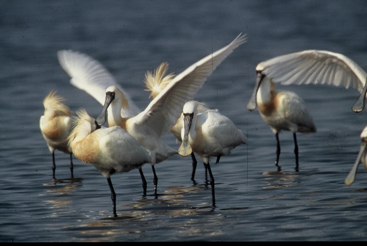
Xuân Thủy National Park is best known as one of the most important migratory bird habitats in Southeast Asia. The park serves as a critical staging and wintering ground for shorebirds, gulls, and waterfowl traveling along the East Asian-Australasian flyway. It hosts the largest population of black-faced spoonbill in Vietnam, with 65 to 75 individuals recorded during migration season, representing about 5% of the global population of this endangered species. The park is also notable for supporting globally threatened species including the spoon-billed sandpiper and Nordmann's greenshank. Its extensive mangrove forest ecosystem, the largest in northern Vietnam, provides flood protection, soil stabilization, and nursery habitat for diverse aquatic species.

Several black-faced spoonbills wading in shallow water with wings extended, showing their distinctive long flat bills and white plumage
Black-faced spoonbills wading in shallow water at Xuân Thủy National Park

Xuân Thủy National Park history and protected-area timeline

Xuân Thủy National Park traces its protected status to January 1989, when the 12,000-hectare area around the Red River mouth was designated as Southeast Asia's first Ramsar site, becoming the 50th such site worldwide. This international recognition came after six years of preparation and advocacy, establishing the area's significance for waterbird conservation. In 1995, the Vietnamese government established the Xuân Thủy Wetland Natural Reserve, formalizing national protection. The park achieved its current status on January 2, 2003, when Prime Minister Nguyễn Tấn Dũng signed Decision 01/2003/QĐ-TTg, elevating the reserve to national park status and placing it under the management of the Nam Định Province People's Committee's Department of Agriculture and Rural Development. In December 2004, UNESCO recognized the park as part of the core zone of the Red River Biosphere Reserve. The park's evolution reflects Vietnam's growing commitment to wetland conservation and international environmental cooperation, with support from various governmental and non-governmental organizations.

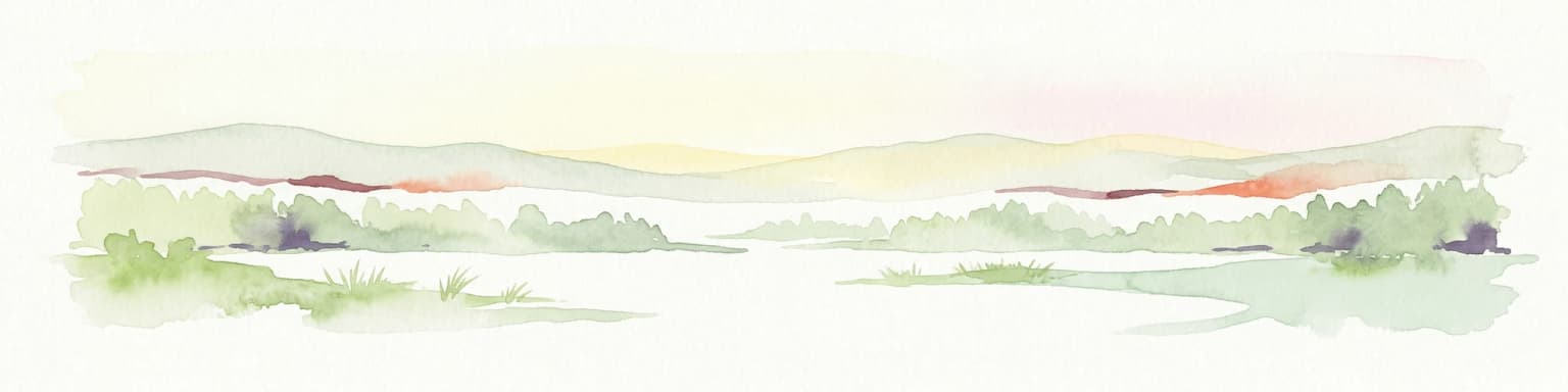
Xuân Thủy National Park landscape and geographic character

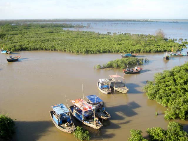
The physical landscape of Xuân Thủy National Park consists of a complex delta and estuarine environment where the Red River meets the Gulf of Tonkin. The park's terrain is predominantly flat and low-lying, characterized by alluvial soils deposited over millennia by riverine and tidal processes. Three primary islands dominate the core zone: Con Ngan (the largest, supporting extensive aquaculture farms and mangrove forest), Con Lu (characterized by sandy alluvial flats and expanding through ongoing sediment deposition), and Con Xanh. The landscape includes extensive mudflats exposed at low tide, mangrove-lined channels, and reclaimed land enclosed by sea dikes. The Ba Lat river mouth creates a distinctive estuarine environment supporting coastal mangroves and the mudflat ecosystem. Soils in the area range from alluvial mud (developing into loam) to sandy coastal soils, with heavy clay deposits in lower-lying areas. The landscape remains dynamic, with Con Lu actively expanding through ongoing alluvium deposition from the Red River.

Aerial view of a brown waterway surrounded by dense green mangrove forests with several fishing boats anchored in the water
Mangrove wetland landscape with fishing boats on the water in Xuân Thủy National Park

Xuân Thủy National Park ecosystems, habitats, and plant life

The ecological character of Xuân Thủy is defined by its coastal wetland ecosystem, which supports exceptional biodiversity across multiple habitat types. The park contains approximately 120 vascular plant species, with around 20 adapted to permanent wetland conditions. The mangrove forests represent the dominant vegetation community, stabilizing alluvial soils, providing flood protection, and functioning as nurseries for aquatic species. Over 500 species of benthos and zooplankton, including shrimp, fish, crabs, and oysters, have been recorded within the park's waters. The aquatic plant community includes 111 species from 43 genera across 20 families of macroalgae, with diatoms dominating. Certain seaweed species hold significant economic value, with Gracilaria species used for agar production. The ecosystem supports fundamental biochemical cycles and provides critical services including carbon sequestration, water filtration, and sediment stabilization. The interaction between freshwater and saltwater creates a dynamic estuarine environment supporting species adapted to varying salinity levels.

Traditional wooden fishing boats anchored in shallow water with distant horizon line
Traditional fishing boats floating on calm water in Xuân Thủy National Park's wetland area

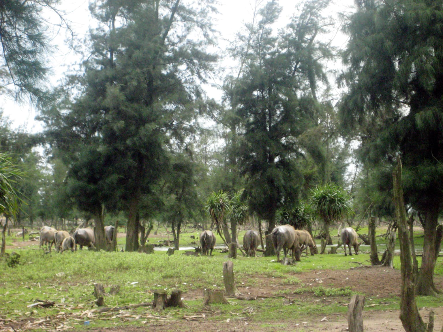
Xuân Thủy National Park wildlife and species highlights

Xuân Thủy National Park supports an extraordinary concentration of birdlife, with approximately 250 species from 41 families and 13 orders documented, including 150 migratory species and 50 waterbird species. Nine species are globally threatened according to the IUCN Red List, most notably the critically endangered spoon-billed sandpiper and the endangered Nordmann's greenshank. The black-faced spoonbill, chosen as the park's symbol, visits in numbers representing about 5% of the global population, typically 65 to 75 individuals during the migratory season. The park serves as a vital staging and wintering area for shorebirds, gulls, and waterfowl crossing the East Asian-Australasian flyway. Beyond avifauna, the park provides habitat for marine mammals including Chinese white dolphins, finless porpoises, and rorqual whales. Otter species and approximately 30 reptile species have been recorded, alongside diverse insect communities. The wetland ecosystem supports fish communities dominated by Perciformes and Pleuronectiformes orders, with economically important species including barramundi, mackerel, and eel providing significant income for local communities.

Water buffaloes grazing in a grassy field with scattered trees and muddy patches
Water buffaloes grazing in a grassy area within Xuân Thủy National Park

Xuân Thủy National Park conservation status and protection priorities

Xuân Thủy National Park represents a cornerstone of wetland conservation in Southeast Asia, serving as the region's first and most internationally recognized protected coastal wetland. Its Ramsar designation in 1989 established the precedent for wetland protection across the region, while its inclusion in the Red River Biosphere Reserve reinforces its role in broader landscape-level conservation. The park's conservation significance derives from its role as a critical node in the East Asian-Australasian flyway, supporting globally significant populations of migratory waterbirds. Conservation challenges include managing the approximately 19 extensive shrimp-rearing ponds within the core zone, addressing illegal bird hunting, and preventing buffalo grazing that damages mangrove regeneration. Projects such as the Mushroom Club provide alternative livelihoods reducing pressure on natural resources, while environmental education programs in nine local schools build community stewardship. Co-management arrangements for clam culture demonstrate successful collaboration between park authorities and local fishers, though institutional capacity strengthening remains an ongoing priority.

Xuân Thủy National Park cultural meaning and human context

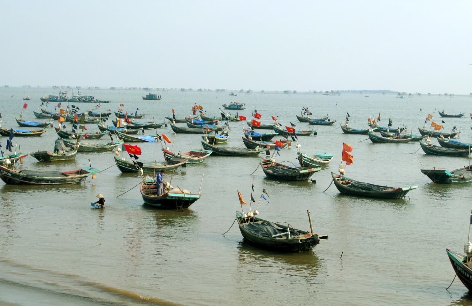
The Xuân Thủy area reflects centuries of human interaction with the coastal wetland environment, embodying the flooded rice cultivation traditions of the Red River Delta. Local communities practice the VAC model integrating vegetable gardens, fish ponds, and animal husbandry within homesteads, alongside silvofishery systems combining mangrove management with aquaculture. The Ba Lat river mouth region represents a cultural cradle of wetland civilization, one of the birthplaces of Vietnam's rice-farming civilization. Traditional fishing using small boats remains integral to local livelihoods, while aquaculture ponds for shrimp and clam cultivation dominate the buffer zone. The area hosts diverse religious communities including Buddhists, Catholics, and followers of folk traditions, reflected in temples, churches, and traditional architecture. Cultural practices such as traditional boat racing, folk dancing, and seasonal festivals maintain community cohesion tied to the wetland landscape and agricultural calendar.

Top sights and standout views in Xuân Thủy National Park

Xuân Thủy National Park stands as Vietnam's premier coastal wetland conservation site, combining international Ramsar recognition with exceptional biodiversity value. The park's mangrove forests represent the largest coastal wetland ecosystem in northern Vietnam, providing critical habitat for migratory birds along the East Asian-Australasian flyway. Sightings of the endangered black-faced spoonbill, with up to 5% of the global population wintering here, represent a flagship conservation achievement. The dynamic landscape of shifting islands, mudflats, and channel systems offers a vivid demonstration of deltaic processes in action. The park's integration of conservation with sustainable community livelihoods through initiatives like mushroom cultivation and ecotourism provides a model for coastal wetland management. Scientific research conducted by Vietnamese and international organizations has produced significant knowledge on wetland ecology, migratory bird patterns, and sustainable development approaches.

Best time to visit Xuân Thủy National Park

The optimal time to visit Xuân Thủy National Park coincides with the migratory bird season from October through April, when shorebirds, waterfowl, and the iconic black-faced spoonbill are present in the greatest numbers. November to March represents the cool, dry season with comfortable temperatures averaging around 24°C, though winter months can see temperatures drop to 6.8°C. The hot, rainy season from April to October brings higher temperatures (up to 40.3°C) and heavy rainfall, with the park receiving 1700-1800mm annually. July and August represent the stormiest period, coinciding with Red River flooding and the northeast monsoon. Visitors seeking birdwatching opportunities should plan for the winter months when the maximum number of species can be observed, though the wetland's year-round ecological value provides meaningful experiences in any season. The park's accessibility and facilities remain under development, with basic guest accommodations available and planned upgrades through 2025.

Park location guide

Geography guide, regional context, and park location map for Xuân Thủy National Park

Xuân Thủy National Park park geography, regions, and map view in Vietnam
Understand where Xuân Thủy National Park sits in Vietnam through a broader geographic reading of the surrounding landscape, nearby location context, and its mapped position within the national park landscape.

How Xuân Thủy National Park fits into Vietnam

Vietnam, officially the Socialist Republic of Viet Nam, is a unitary communist state in Southeast Asia. It occupies roughly 331,000 square kilometres along the eastern edge of Mainland Southeast Asia, with a population exceeding 102 million. The country is bordered by China to the north, Laos and Cambodia to the west, and has maritime boundaries in the Gulf of Thailand and South China Sea.

Wider geography shaping Xuân Thủy National Park in Vietnam

Vietnam occupies the eastern edge of Mainland Southeast Asia, stretching along the Gulf of Thailand to the southwest and the South China Sea to the east. The country is bordered by China to the north, and Laos and Cambodia to the west. It has a diverse landscape ranging from the Red River Delta in the north to the Mekong Delta in the south.

Map view of Xuân Thủy National Park

Use this park location map to pinpoint Xuân Thủy National Park in Vietnam, understand its exact geographic position, and read its mapped placement within the surrounding landscape more clearly.

Pigeon | © OpenStreetMap contributors

Location context for Xuân Thủy National Park

Nam Định Province

Browse imagery showcasing the park's dynamic delta ecosystem, mangrove forests, and vital migratory bird habitats.

Xuân Thủy National Park Photos: Explore Coastal Wetland Landscapes and Habitats
Visually explore Xuân Thủy National Park's diverse landscapes, showcasing its expansive coastal wetlands, dynamic estuarine terrain, and vital mangrove forest ecosystems. Understanding these images provides clear insight into the park's protected-area character and its essential role as a migratory bird habitat along the Red River Delta.

Several black-faced spoonbills wading in shallow water with wings extended, showing their distinctive long flat bills and white plumage

Several white birds with long spatulate bills standing in shallow water among mangrove vegetation

Aerial view of a brown waterway surrounded by dense green mangrove forests with several fishing boats anchored in the water

Traditional wooden fishing boats anchored in shallow water with distant horizon line

Water buffaloes grazing in a grassy field with scattered trees and muddy patches

Grassy field with scattered small trees and larger trees in the background under a cloudy sky

Park atlas

Compare coastal wetlands, delta ecosystems, and diverse protected landscapes across northern Vietnam and the Red River Delta region.

Explore Other National Parks and Protected Areas Near Xuân Thủy National Park in Vietnam
Continue your exploration from Xuân Thủy National Park by browsing other national parks and protected areas, mapping their locations across Vietnam's northern coastal regions and the Red River Delta. Compare their unique protected landscapes and discover additional conservation sites within similar deltaic or wetland environments.
National parkVietnam

Cát Bà National Park: Vietnam's Critically Endangered Species Sanctuary & Karst Landscape

Mapped protected area with diverse terrestrial and marine ecosystems.

As a critical national park in Vietnam, Cát Bà National Park protects a remarkable limestone karst landscape central to the Hạ Long Bay region. This area is renowned for its steep peaks, narrow valleys, and coastal mangrove environments, supporting a uniquely diverse array of flora and fauna. Its status as a protected area highlights its global importance for conservation, particularly as the exclusive habitat of the Cát Bà langur. Explore the mapped geography and ecological significance of this vital Vietnamese protected land.

Area
161.968 km²
Established
1986
IUCN
II
Relief
Highland
National parkThanh Hóa Province

Ben En National Park: Vietnam National Park Geography and Mapped Landscape Context

Explore protected area boundaries and regional terrain.

Ben En National Park represents a key protected natural area within Thanh Hóa Province, Vietnam. This detail page facilitates a structured discovery of its geographic features, mapped extent, and its significance as a national park. Dive into the atlas context to understand the park's landscape and its regional setting, offering a factual foundation for geographic exploration.

Area
147.35 km²
Established
1992
IUCN
II
Visitors
6.6K annual
Watercolor painting showing a coastal landscape with distant islands, green vegetation, and a horizon line
National parkQuảng Ninh Province

Bái Tử Long National Park: Protected Island Archipelago and Marine Landscape Discovery

Explore the geography and mapped protected boundaries.

Bái Tử Long National Park, located in Vietnam's Quảng Ninh Province, is a protected national park distinguished by its archipelago of approximately 40 limestone islands and significant marine environments. As one of Vietnam's few national parks designated to protect both land and sea, it provides critical atlas-level insights into coastal karst topography, marine biodiversity, and the interconnectedness of island ecosystems. Discover the park's unique geographic features and its role as a vital protected landscape within the broader regional context.

Area
157.83 km²
Established
2001
IUCN
II
Relief
Mixed relief
National parkHanoi

Ba Vì National Park: Ancient Volcanic Mountains and Protected Landscape Near Hanoi

Discover the mapped geography and biodiversity of this national park.

Ba Vì National Park, a protected natural area near Hanoi, showcases a dramatic landscape shaped by ancient volcanic activity. The park features three significant peaks, including Vua Mountain, creating a distinct topographical profile. Spanning over 10,800 hectares, it is recognized for its ecological diversity, harboring a wealth of plant and animal species. This national park serves as a vital protected landscape, offering a unique opportunity for geographic exploration and understanding the natural terrain surrounding the Vietnamese capital.

Area
108.15 km²
Established
1991
IUCN
II
Relief
Mountain
National parkVĩnh Phúc Province

Tam Dao National Park: Vietnam's Mountain National Park and Biodiversity Hotspot

Explore mapped boundaries and regional landscape context.

Tam Dao National Park is a key protected area in northern Vietnam, defined by its rugged mountain terrain featuring over 20 peaks exceeding 1,000 meters. This national park is a vital habitat for diverse flora and fauna, including numerous endemic species, and showcases transitional forest ecosystems from tropical to montane zones. Understanding Tam Dao National Park involves exploring its geographic setting within Vĩnh Phúc Province and appreciating its role as a significant protected landscape.

Area
368.83 km²
Established
1996
IUCN
II
Relief
Mountain
National parkPhú Thọ Province

Xuân Sơn National Park: Protected Mountain Landscape and Regional Geography

Mapping the southeastern edge of the Hoang Lien Mountains.

Delve into the protected landscape of Xuân Sơn National Park, a key national park situated in Phú Thọ Province, Vietnam. This area, covering about 150 square kilometers, is defined by its rugged mountainous terrain, featuring steep forested slopes and distinct ridgelines that contribute to the region's varied topography. As a protected national park, Xuân Sơn plays a crucial role in preserving the natural characteristics of the southeastern Hoang Lien Mountains. Its geographic setting is significant, acting as a transition zone between higher montane environments and the nearby lowland river systems, offering a unique perspective on Vietnam's diverse natural heritage.

Area
150.48 km²
Established
1986
IUCN
II
Relief
Mountain
National parkNghệ An Province

Pù Mát National Park: National Park Protected Landscape and Geographic Mapping

Explore Nghệ An Province's protected area context.

Pù Mát National Park is a key protected area situated in Nghệ An Province, Vietnam. This entry focuses on its role as a national park, detailing its mapped boundaries and geographic features. It serves as a vital point for understanding the distribution of protected lands and the natural landscape context within the broader regional atlas. Discover the specific geographic identity and atlas significance of Pù Mát National Park.

Area
911.13 km²
Established
2001
IUCN
II
Relief
Mountain
National parkHà Tĩnh Province

Vũ Quang National Park: Protected Landscape Identity and Geographic Context in Hà Tĩnh

National Park Discovery and Mapped Terrain Exploration

Investigate Vũ Quang National Park, a key protected area situated in Hà Tĩnh Province. This page provides detailed insight into the park's designation as a national park, focusing on its mapped boundaries, surrounding natural landscapes, and contribution to the regional geography. It serves as a vital resource for understanding the park's protected landscape characteristics and its place within Vietnam's atlas of conservation areas.

Area
550.28 km²
Established
2002
IUCN
II
Relief
Mountain

Common questions about visiting, size, designation, and location context for Xuân Thủy National Park

Xuân Thủy National Park FAQs for park facts, access, geography, and protected area context
Find quick answers about Xuân Thủy National Park, including protected-area facts, park geography, trail and visitor context, and how the park fits into its surrounding country and regional landscape.
MoriAtlas Explorer

Continue Your Protected Areas Search Across the Global Atlas

Deepen your exploration by continuing the structured search for national parks and protected areas worldwide. Utilize the comprehensive filtering capabilities to compare different conservation landscapes and refine your understanding of global park geography. Discover more about the distribution and characteristics of protected natural areas.

Global natural geography