
Mori Atlas logo
National parkZaybaykalsky National Park

A comprehensive look at the peninsula, islands and taiga ecosystems defining this Russian protected region

Zaybaykalsky National Park: Protected Landscape Geography, Mountain Terrain and Lake Baikal Boundaries

Zaybaykalsky National Park encompasses a significant stretch of Lake Baikal's eastern shore in the Republic of Buryatia. The protected area features the distinct Svyatoy Nos peninsula, rugged Barguzin mountain slopes, and the Ushkany Islands archipelago. By analyzing the intersection of subarctic taiga forests and steep aquatic topography, this record provides essential context on one of Russia's most geographically complex wilderness landscapes.

Lake BaikalTaigaNational ParkPeninsulaIslandsEastern Siberia
A flat-style digital illustration showing a view of a blue lake with a prominent rock formation in the water, a sandy beach, and a coniferous forest in the foreground, with mountains and a sunrise in the distance.

Zaybaykalsky National Park

National park

Park overview

Structured park overview, official facts, and landscape profile for Zaybaykalsky National Park

Zaybaykalsky National Park park facts, protected area profile, and essential visitor context

Review the core facts for Zaybaykalsky National Park, including designation, size, terrain, visitor scale, habitats, and operating context in one park-focused overview.

About Zaybaykalsky National Park

Zaybaykalsky National Park represents one of Russia's most significant protected areas for conserving the unique ecosystems surrounding Lake Baikal, a UNESCO World Heritage Site. The park encompasses approximately 269,000 hectares along the eastern shore of Lake Baikal in the Republic of Buryatia, making it a substantial component of the Baikal region's protected area network. The park's boundaries are defined by Lake Baikal to the west, the Barguzin Nature Reserve to the north, and the Barguzin mountain range to the south and east. This positioning creates a contiguous protected corridor that spans from the lakeshore through mountain forests to alpine zones. The park's establishment in 1986 reflected growing recognition of the ecological and scenic importance of the Trans-Baikal region, the area lying beyond the Baikal watershed. The park is administered by Russia's Ministry of Natural Resources and Environment and operates visitor facilities including guest cabins and a floating ecotourist hostel. The park's management balances conservation objectives with sustainable tourism, requiring special permits for highly sensitive areas such as the Ushkany Islands while offering day-pass access to most of the park's recreational zones.

Quick facts and research context for Zaybaykalsky National Park

Zaybaykalsky National Park covers 269,000 hectares in Buryatia, Russia, along the eastern shore of Lake Baikal. The park was established in 1986 and is managed by Russia's Ministry of Natural Resources and Environment. Its landscape is dominated by the steep eastern slopes of the Barguzin mountain range, with the highest peak at 2,376 meters. The park includes the Svyatoy Nos peninsula, the Ushkany Islands, and the Chivyrkuisky isthmus connecting the peninsula to the mainland. The climate is subarctic with January averages of -18°C and July highs around 23°C. The park is part of the East Siberian taiga ecoregion and supports old-growth forest stands covering approximately 10,000 hectares.

Protection and recognition

Examining documented protected area designation and management frameworks

Zaybaykalsky National Park Protection Status and Management Scope

Zaybaykalsky National Park maintains a documented mixed protection status within regional conservation inventories. Official records assemble management scopes and designation details for rigorous geographic study.

Protection details

Protection scope
Mixed
Transboundary protection
No
Park context

Deeper park guide and search-rich context for Zaybaykalsky National Park

Zaybaykalsky National Park history, landscape, wildlife, and travel context

Explore Zaybaykalsky National Park through its history, landscape character, ecosystems, wildlife, conservation priorities, cultural context, and seasonal travel timing in a structured park guide built for atlas discovery and search intent.

Why Zaybaykalsky National Park stands out

Zaybaykalsky National Park is best known for its remarkable geographic diversity along Lake Baikal, one of the world's oldest and deepest freshwater lakes. The park protects the Svyatoy Nos peninsula, the lake's only large peninsula, which offers panoramic views across the water to distant mountain ranges. The Ushkany Islands, an archipelago of four islands, serve as the central breeding ground for the Baikal seal, the only freshwater seal species in the world. The peninsula's Marokov beach features so-called "singing sand" that produces distinctive sounds when walked upon. The park's dramatic steep terrain, with 55% of its area on slopes exceeding 26 degrees, creates a rugged landscape of coniferous forests ascending from the lakeshore to alpine meadows. The Chivyrkuisky Isthmus provides a land connection between the peninsula and the mainland, while the underwater Academician Ridge links the islands to Olkhon Island in the southwest.
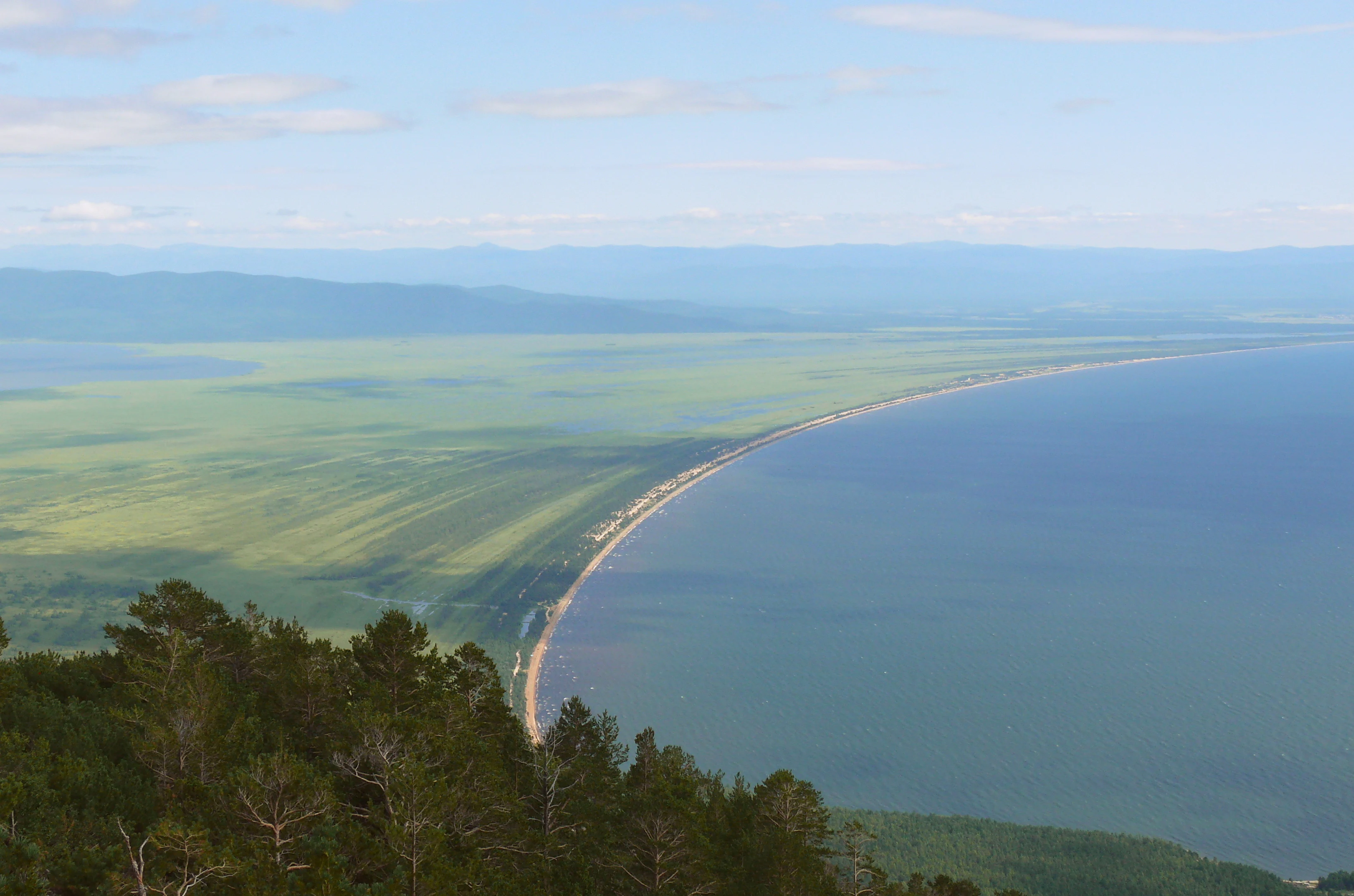
Aerial view of Barguzinsky Bay with a sandy shoreline, green forested hills, and Lake Baikal extending into the distance under a partly cloudy sky
Barguzinsky Bay viewed from Svyatoy Nos Peninsula, Lake Baikal

Zaybaykalsky National Park history and protected-area timeline

Zaybaykalsky National Park was established in 1986 to protect the distinctive landscapes and ecosystems of the Trans-Baikal region along Lake Baikal's eastern shore. The creation of this protected area reflected Soviet-era priorities for nature conservation and the recognition that the Baikal region required comprehensive protection beyond the existing Barguzin Nature Reserve to the north. The park was formed to encompass the diverse terrain between the lake shoreline and the Barguzin mountain range, including the unique Svyatoy Nos peninsula and the ecologically significant Ushkany Islands. The selection of this area for national park status acknowledged both its ecological value as part of the East Siberian taiga and its outstanding scenic qualities. Since establishment, the park has operated under the framework of Russian federal protected area legislation, managed by the Ministry of Natural Resources and Environment. The park's tourism infrastructure has developed over subsequent decades to support visitor access while maintaining protection of sensitive ecosystems, particularly the seal rookeries on the Ushkany Islands.

Zaybaykalsky National Park landscape and geographic character

The landscape of Zaybaykalsky National Park is defined by its dramatic elevation changes from Lake Baikal's shoreline to the peaks of the Barguzin mountains. The park's topography is remarkably steep, with 55% of its area having slopes exceeding 26 degrees and an additional 28% between 16 and 25 degrees. Mt. Barmashovoe, the park's highest point, rises to 2,376 meters above sea level. The Svyatoy Nos peninsula extends 53 kilometers into Lake Baikal and is 35 kilometers at its widest, forming a distinct landform with its own mountain complex reaching 1,877 meters above sea level and 1,422 meters above the lake surface. The peninsula is connected to the mainland by the low-lying Chivyrkuisky isthmus. The Ushkany Islands, located in the middle of the lake, represent the above-water eastern extent of the submerged Academician Ridge, a geological feature that divides Lake Baikal into northern and southern basins. These four islands total approximately 10 square kilometers and are composed of marble and limestone. The peninsula's Marokov beach features the phenomenon known as "singing sand," where walking on the beach produces audible sounds. The islands contain caves with evidence of human occupation dating to the Neolithic period.
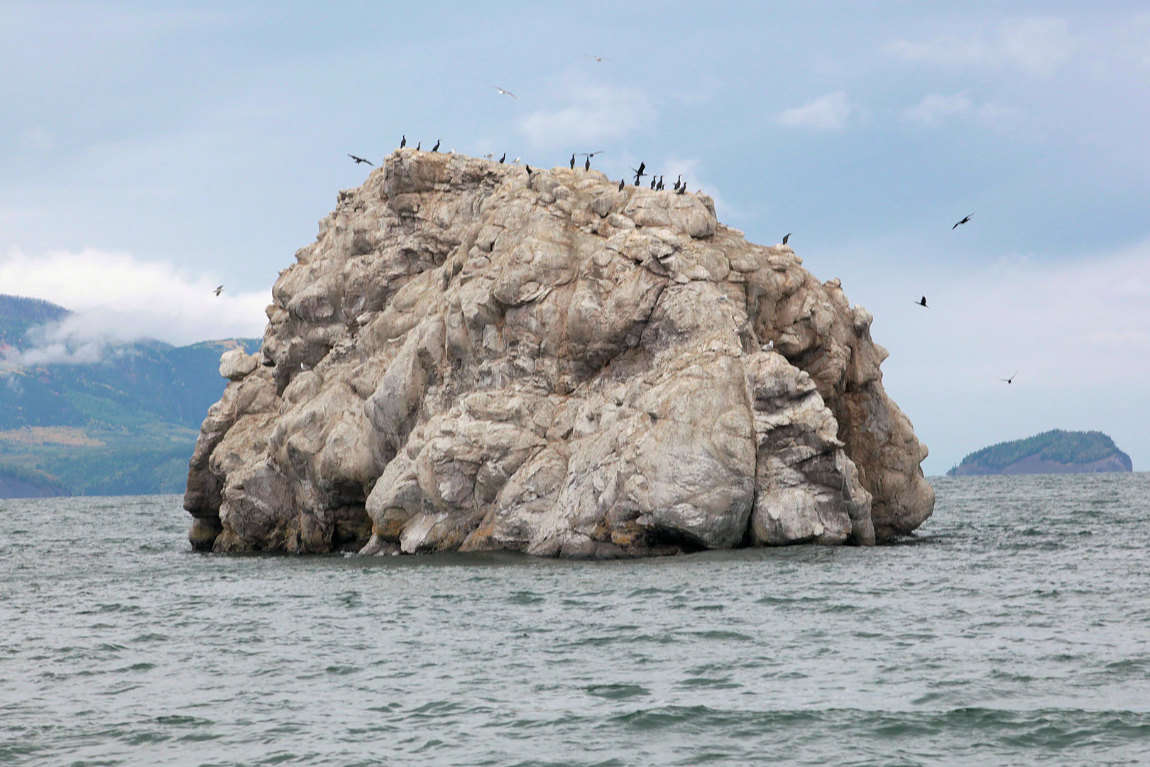
Large rock island in Lake Baikal with numerous birds perched on its surface
Kameshek Island with birds perched on the rock formation in Lake Baikal

Zaybaykalsky National Park ecosystems, habitats, and plant life

Zaybaykalsky National Park lies within the East Siberian taiga ecoregion, a vast expanse of coniferous forest spanning the territory between the Yenisei and Lena Rivers. The park's sharp elevation gradients from lake shore to mountain peaks create distinct altitude zoning in vegetation. The forests are predominantly coniferous, with pine comprising 34% of tree cover, Siberian dwarf pine at 30%, Siberian pine at 14%, and larch at 9%. Approximately 10,000 hectares of old-growth forest stands persist within the park, representing relatively undisturbed examples of Eastern Siberian taiga. The subarctic climate, classified as Dwc under the Köppen system, features long very cold winters and cool summers, with the lake exerting a moderating influence on temperatures. Average January temperatures reach -18°C while July averages 23°C. Annual precipitation ranges from 450 millimeters along the lakeshore to 550 millimeters in the mountains, with prevailing winds from the south and southwest. The vegetation transitions from forest types on lower slopes through Siberian dwarf pine scrub to alpine meadows at higher elevations.

Zaybaykalsky National Park wildlife and species highlights

The fauna of Zaybaykalsky National Park represents the typical species assemblage of southern Siberian forests, with 249 bird species recorded within the territory. Large mammals include bear, wolf, fox, lynx, sable, otter, wolverine, moose, and musk deer, while smaller mammals such as squirrel, chipmunk, muskrat, and hare are widespread. The alpine meadows support the black-capped marmot. The park is particularly significant for its population of Baikal seals, the only freshwater seal species in the world, which gather in concentrations of up to 3,000 individuals on the rocks of the Ushkany Islands during summer months. The islands serve as the central breeding and hauling ground for this endemic species. Bolshoy Ushinsky island contains the largest concentration of large anthills in Russia, with thousands of nests reaching up to 1.5 meters in height. The great cormorant, once extirpated from the region, has returned to the park. The diverse habitats from lakeshore through forest to alpine zones support this variety of species.

Zaybaykalsky National Park conservation status and protection priorities

Zaybaykalsky National Park plays a crucial role in the conservation network protecting Lake Baikal's exceptional biodiversity. As an IUCN Category II protected area, the park maintains both ecological integrity and natural beauty while allowing sustainable use. The park's boundaries connect with the Barguzin Nature Reserve to the north, creating a contiguous protected corridor along Lake Baikal's eastern shore. The protection of the Ushkany Islands is particularly significant as the primary habitat for the Baikal seal, a species endemic to Lake Baikal and one of the world's few freshwater seal populations. The park's old-growth forests, spanning approximately 10,000 hectares, represent important carbon stores and biodiversity reservoirs within the East Siberian taiga. The protection of the Svyatoy Nos peninsula preserves both ecological values and outstanding scenic landscapes. The subarctic ecosystems face pressures from climate change and regional development, making the park's protected status vital for maintaining ecological processes and species populations.

Zaybaykalsky National Park cultural meaning and human context

While Zaybaykalsky National Park is primarily valued for its natural landscapes and ecological significance, the Ushkany Islands contain caves with archaeological evidence of human habitation dating to the Neolithic period. This indicates long-standing human presence in the region, though the park does not encompass significant contemporary indigenous communities or well-documented traditional cultural landscapes. The Svyatoy Nos peninsula derives its name from the Russian for "Holy Nose," reflecting historical naming conventions in the region. The park lies within Buryatia, a republic with strong ties to Tibetan Buddhism and a distinctive cultural heritage blending Siberian and Mongolian influences, though these cultural dimensions are centered in settlements outside the park's boundaries.

Top sights and standout views in Zaybaykalsky National Park

Zaybaykalsky National Park offers exceptional geographic and ecological diversity within a single protected area. The Svyatoy Nos peninsula provides the only large peninsula on Lake Baikal, creating unique vantage points for panoramic views across the lake to distant mountain ranges. The Marokov beach on the peninsula features singing sand, an unusual acoustic phenomenon. The Ushkany Islands support the world's only freshwater seal population, with summer congregations of up to 3,000 individuals. The park's dramatic steep terrain, with old-growth taiga forests ascending from the lakeshore to alpine meadows, exemplifies the East Siberian landscape. The Academician Ridge, partially visible as the Ushkany Islands, connects underwater to Olkhon Island, forming a geological feature that divides Lake Baikal into northern and southern basins. Winter visitors can experience ice fishing and cross-country skiing along the frozen lake margin.

Best time to visit Zaybaykalsky National Park

The optimal visiting season for Zaybaykalsky National Park is summer, from June through August, when average temperatures reach 23°C and the park's trails and recreational areas are fully accessible. This period offers the best conditions for hiking, wildlife viewing, and exploring the peninsula and islands. The brief summer provides the narrow window for observing Baikal seals hauled out on the Ushkany Islands. Spring and autumn provide transitional seasons with fewer visitors but more limited facilities. Winter, from December through February, offers a completely different experience with temperatures dropping to -18°C and Lake Baikal freezing solid, enabling ice fishing and cross-country skiing along the shore. The harsh subarctic climate with its long, very cold winters means that most visitor activities are concentrated in the warm season. Annual precipitation averages 450-550mm, with relatively low snowfall in winter despite the cold temperatures, creating conditions for winter recreation on the ice.
Monthly climate preview

Long-term representative temperature ranges and monthly precipitation rhythm

Zaybaykalsky National Park Climate Normals and Annual Weather Patterns

Zaybaykalsky National Park exhibits a measured annual cycle defined by subzero winter lows and warm summer maximums alongside varying monthly precipitation rates. Accessing the complete twelve-month climate profile provides detailed historical temperature averages and precipitation metrics for structured geographic research.
Annual mean-2 °C
-24 °C20 °C
Jan-24°
Feb-20°
Mar-12°
Apr-1°
May
Jun16°
Jul20°
Aug17°
Sep
Oct-2°
Nov-14°
Dec-22°
Warmest month
July

19.6 °C

Coolest month
January

-23.9 °C

Wettest month
July

2.5 mm/day

Driest month
February

0.5 mm/day

Park location guide

Geography guide, regional context, and park location map for Zaybaykalsky National Park

Zaybaykalsky National Park park geography, regions, and map view in Russia

Understand where Zaybaykalsky National Park sits in Russia through a broader geographic reading of the surrounding landscape, nearby location context, and its mapped position within the national park landscape.

How Zaybaykalsky National Park fits into Russia

Russia is a transcontinental nation spanning eleven time zones, bordered by fourteen countries. It is the world's largest country by area, covering 17,098,246 km². Moscow is the capital and largest city, while Saint Petersburg is the second-largest and a major cultural centre.

Wider geography shaping Zaybaykalsky National Park in Russia

Russia spans Eastern Europe and North Asia, covering 17,098,246 km². It shares land borders with fourteen countries, more than any other nation, and spans eleven time zones. The landscape includes vast plains, mountain ranges such as the Urals and Caucasus, and extensive coastlines along the Arctic Ocean, Pacific Ocean, Baltic Sea, Black Sea, and Caspian Sea.

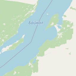
Map view of Zaybaykalsky National Park

Use this park location map to pinpoint Zaybaykalsky National Park in Russia, understand its exact geographic position, and read its mapped placement within the surrounding landscape more clearly.

Pigeon | © OpenStreetMap contributors

Location context for Zaybaykalsky National Park

Buryatia

Visual reference of protected taiga forests, rugged mountain terrain, and lake shores

Zaybaykalsky National Park Photos and Landscape Scenery

Protected area photography reveals the dramatic elevation changes and taiga habitats that define the eastern shore of Lake Baikal. Visual documentation helps researchers and visitors analyze regional terrain characteristics without traveling on site.

Aerial view of Barguzinsky Bay with a sandy shoreline, green forested hills, and Lake Baikal extending into the distance under a partly cloudy sky

Calm blue lake water with a forested shoreline and mountain range under a clear sky

Large rock island in Lake Baikal with numerous birds perched on its surface

Park atlas

Compare regional park geography and adjacent taiga habitats across Eastern Siberia

Parks Near Zaybaykalsky National Park and Surrounding Protected Landscapes

Browsing national parks near Zaybaykalsky National Park reveals shared taiga ecosystems and dramatic lake topography. Comparing adjacent protected areas provides deeper context on regional geography and protected landscapes.
National parkBuryatia
About 0 km away#1 closest

Southwest

Zabaykalsky National Park: Geographic and Protected Area Mapping for the Eastern Baikal Shore

Mountain taiga, islands, and protected peninsula landscapes.

Zabaykalsky National Park comprises an extensive area of the eastern Baikal shoreline, characterized by the Barguzin Range, the prominent Sviatoy Nos peninsula, and a dense network of mountain taiga forests. Its protected boundaries include diverse mineral springs, karst features, and crucial marine habitats, providing a comprehensive look at the unique geomorphology and biodiversity of this Siberian wilderness.

Area
2,690 km²
Established
1986
IUCN
II
Relief
Mountain
Watercolor illustration showing a lake, green vegetation, and mountains under a light sky
National parkIrkutsk Oblast
About 83 km away#2 closest

Southwest

Pribaikalsky National Park: Geographic Context and Protected Landscape Boundaries

Coastal mountain terrain and the freshwater ecosystems of Irkutsk Oblast.

Located in Russia, Pribaikalsky National Park represents a primary protected area within the Lake Baikal basin. The region features dramatic topographical transitions from the Primorsky Range to the inland expanse of Olkhon Island. This record provides a detailed look at the park's physical geography, including its forest cover, coastal cliffs, and the significant role of the Angara River outflow in shaping the surrounding Siberian terrain.

Area
4,173 km²
Established
1986
IUCN
II
Visitors
400K annual
Soft watercolor painting of a lakeshore with rolling hills, coniferous trees, and a distant mountain horizon.
National parkIrkutsk Oblast
About 230 km away#3 closest

Southwest

Pribaikalsky National Park: Atlas and Geographic Overview of Lake Baikal Shoreline

Protected taiga, rift valleys, and Olkhon Island topography

Pribaikalsky National Park serves as a critical protected landscape featuring 470 kilometers of western shoreline along Lake Baikal. Its geography is defined by the steep scarps of the Obruchev fault, the dense taiga of the Primorsky Range, and the unique steppe environments of Olkhon Island. This atlas entry provides essential context on the physical relief and regional characteristics of this landmark Siberian protected area.

Area
4,173 km²
Established
1986
IUCN
II
Visitors
400K annual
Watercolor painting of a river winding through a grassy plain toward distant rolling hills under a soft light.
National parkZabaykalsky Krai
About 430 km away#4 closest

Southeast

Alkhanay National Park: Protected Mountain Terrain and Volcanic Landscapes of Zabaykalsky Krai

Mapping Siberia's forest-steppe transition and sacred mountain geography

Alkhanay National Park preserves an unusual assembly of Siberian mountain taiga, volcanic geology, and Buddhist heritage sites within the Zabaykalsky Krai region. The protected territory spans mid-elevation ranges and river valleys, offering deep insights into the intersection of ecological watershed protection and spiritual land preservation in the Russian Far East.

Area
1,382.34 km²
Established
1999
IUCN
II
Visitors
30K annual
Watercolor illustration depicting layered mountains, green hills, and forested areas with purple and pink tones
National parkZabaykalsky Krai
About 430 km away#5 closest

Southeast

Alkhanay National Park: A Study of Sacred Peaks and Daurian Forest Steppe Geography

Protected mountain landscapes in Russia's Zabaykalsky Krai

Alkhanay National Park preserves a unique transitional landscape where rugged mountain terrain meets the expansive Siberian steppe. Focused on the sacred Mount Alkhanai, the area features dramatic rock landforms, pine-covered canyons, and mineral springs. This protected zone provides a deep look into the geological and ecological history of the Mogotuyskogo Range and surrounding border regions.

Area
1,382 km²
Established
1999
IUCN
II
Relief
Mountain
Watercolor painting of a river winding through hills with trees and vegetation
National parkZabaykalsky Krai
About 446 km away#6 closest

South

Chikoy National Park: Protected National Park with Highland Landscape and River Basin Geography

Explore its protected boundaries and unique taiga-steppe transition in Zabaykalsky Krai.

Chikoy National Park, a protected area in Russia's Zabaykalsky Krai, showcases the rugged geography of the Khentei-Daur Highlands. As a national park, it preserves the upper Chikoy River basin and represents a significant ecological borderland, marking the transition from Siberian taiga to Mongolian steppe. This page facilitates a structured understanding of the park's mapped landscape, its prominent natural monument Bystrinsky Golets, and its role within the broader atlas of protected natural areas.

Area
6,665 km²
Established
2014
IUCN
II
Relief
Mountain
National parkBuryatia
About 529 km away#7 closest

West

Tunkinsky National Park National Park: Protected Landscape and Geographic Context in Buryatia

Discover mapped park boundaries and regional terrain.

Delve into Tunkinsky National Park, a significant protected national park situated in the Buryatia region of Russia. This detail page provides a geographic overview, highlighting the park's mapped boundaries and its place within the surrounding natural landscape. Understand its designation as a protected area, offering a focused entry point for atlas-based discovery of its specific terrain and regional importance.

Area
11,837 km²
IUCN
II
Relief
Mountain
Climate
Boreal
Wildlife reserveKhentii Province
About 535 km away#8 closest

South

Khan Khentii Strictly Protected Area: Geographic Overview and Protected Landscape Mapping

Eastern Mongolia wilderness and Khentii mountain terrain

Explore the expansive reaches of Khan Khentii Strictly Protected Area, a cornerstone of Mongolian conservation. This reserve shields intact taiga forests, river valley habitats, and the historic Burkhan Khaldun mountain from industrial activity, preserving one of the most significant mountain wilderness regions in the province of Khentii.

Area
12,270 km²
Established
1992
IUCN
Ib
Relief
Mountain

Common questions about visiting, size, designation, and location context for Zaybaykalsky National Park

Zaybaykalsky National Park FAQs for park facts, access, geography, and protected area context

Find quick answers about Zaybaykalsky National Park, including protected-area facts, park geography, trail and visitor context, and how the park fits into its surrounding country and regional landscape.
MoriAtlas Explorer

Continue Your Protected Areas Search Across the Global Atlas

Deepen your exploration by continuing the structured search for national parks and protected areas worldwide. Utilize the comprehensive filtering capabilities to compare different conservation landscapes and refine your understanding of global park geography. Discover more about the distribution and characteristics of protected natural areas.

Global natural geography