
Mori Atlas logo
Nature reserveZigeunerwäldchen

Mapping the ecological relief and riparian woodland boundaries of this lowland nature reserve

Zigeunerwäldchen Nature Reserve: A Protected Haller River Floodplain Landscape in Lower Saxony

Zigeunerwäldchen serves as a critical relict of near-natural riparian woodland situated along the Haller river floodplain in Lower Saxony. This nature reserve, characterized by willow-dominated alluvial forest, dense swamp clearings, and rich sedge communities, represents a preserved mosaic of lowland riverine terrain amidst the wider agricultural plains of the Hannover region. The area functions as an essential ecological refuge for floodplain-dependent vegetation and woody habitats.

floodplain forestriparian woodlandalluvial forestswamp forestwillow woodlandmarshland
A flat-style digital illustration of a mountain valley featuring pine forests, a winding stream, a waterfall, and a bright sun in a clear sky.

Zigeunerwäldchen

Nature reserve

Park overview

Structured park overview, official facts, and landscape profile for Zigeunerwäldchen Nature Reserve

Zigeunerwäldchen Nature Reserve park facts, protected area profile, and essential visitor context

Review the core facts for Zigeunerwäldchen Nature Reserve, including designation, size, terrain, visitor scale, habitats, and operating context in one park-focused overview.

About Zigeunerwäldchen Nature Reserve

Zigeunerwäldchen is a compact nature reserve in the Hannover region of Lower Saxony that protects one of the few surviving pieces of the Haller river floodplain. Although the reserve is only about 15 hectares in size, it preserves a diverse mosaic of wetland woodland habitats that have largely disappeared from the surrounding agricultural landscape.

The reserve sits between the districts of Eldagsen and Gestorf at the base of the Abraham hill, a notable local elevation in the Calenberger Land. The Haller river, a tributary of the Leine, runs through the area and historically shaped a low, wet floodplain. Today this floodplain is represented by willow-dominated alluvial forest, swamp forest remnants, and open marshy clearings. Willows form the backbone of the woodland, while a high share of tree fungi and substantial amounts of standing and lying deadwood give the forest its near-natural character.

In addition to the forested core, the western and southern parts of the reserve include areas of grassland. The protected area is mostly bordered by arable farmland and is largely encircled by the broader Hallerniederung landscape protection area. Ecologically, Zigeunerwäldchen is significant because it provides a refuge for floodplain species and associated wetland communities within a landscape dominated by agriculture. Its small size makes it all the more important as a biodiversity foothold and a stepping stone for conservation within the region.

Conservation ownership gives the reserve a distinct institutional history. The land was purchased in 1983 by what is now NABU Springe and formally designated as a nature reserve in 1986. Through a land pool arrangement, the area was transferred to the Biotop-Management-Initiative association, while a NABU-affiliated foundation established in 2012 continues to support stewardship, habitat restoration along the Haller, and the creation of connected green corridors to nearby woodlands.

Quick facts and research context for Zigeunerwäldchen Nature Reserve

Zigeunerwäldchen is officially designated as the nature reserve NSG HA 115 and lies within the administrative area of the city of Springe, Hannover region, Lower Saxony. It encompasses roughly 15 hectares of floodplain forest along the Haller river and is largely surrounded by the Hallerniederung landscape protection area. The reserve has been legally protected since December 18, 1986. It was acquired in 1983 by the German League for Bird Protection (later NABU Springe) and remains primarily managed by conservation organizations associated with that group.

Protection and recognition

Documented conservation data and protected area records for Zigeunerwäldchen.

Zigeunerwäldchen Protection Status and Official Designation Records

Zigeunerwäldchen features documented protection metrics and official conservation records compiled from verified databases. Available designation history and administrative frameworks provide clear reference points for natural area research.

Protection details

WDPA ID
166419
Park context

Deeper park guide and search-rich context for Zigeunerwäldchen Nature Reserve

Zigeunerwäldchen Nature Reserve history, landscape, wildlife, and travel context

Explore Zigeunerwäldchen Nature Reserve through its history, landscape character, ecosystems, wildlife, conservation priorities, cultural context, and seasonal travel timing in a structured park guide built for atlas discovery and search intent.

Why Zigeunerwäldchen Nature Reserve stands out

Zigeunerwäldchen is best known as a small, ecologically valuable remnant of alluvial and swamp forest along the Haller river. Its stands of willows, abundant deadwood, tree fungi, and marshy clearings with reed and large sedge communities make it a notable example of a near-natural lowland floodplain woodland in an otherwise heavily farmed region. The reserve also carries cultural interest through its historical association with Sinti and Roma communities in the Eldagsen area and reflects how human land use, including a disused brickworks pit, helped shape the present woodland.
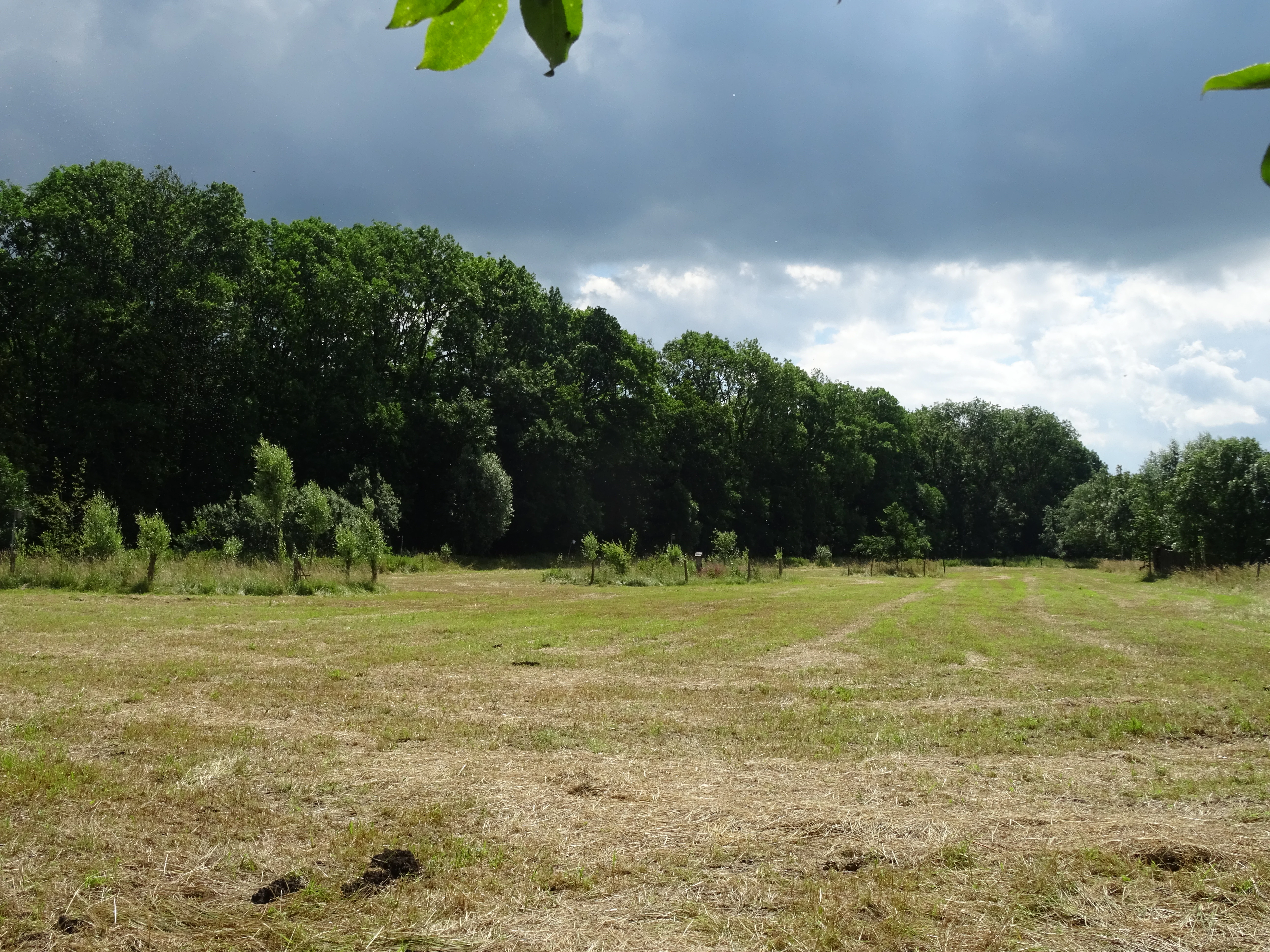
A wide landscape shot of a mown grassy field leading to a dense line of mature green trees under a cloudy sky.
A view of the open meadow and forest edge within Zigeunerwäldchen nature reserve.

Zigeunerwäldchen Nature Reserve history and protected-area timeline

The history of Zigeunerwäldchen is closely linked to the surrounding Haller river floodplain and the historical land use of the Eldagsen area. Originally, the land between the newer southern course of the Haller and the older northern course was a meadow used as horse pasture. In the nineteenth century, a brickworks operated just to the west on a plot known as "Auf den Bülten," and from 1849 the brickworks leased the meadow both for clay extraction and for continued haymaking.

Early in the twentieth century the brickworks was shut down and demolished, and the demolition rubble was deposited in the clay pit that the operation had created. The lower-lying, now swampy ground gradually turned into woodland rather than being returned to agriculture. This human-made change in ground level, combined with the wet conditions, allowed a floodplain forest to develop where meadowland had existed.

The name of the woodland reflects a separate chapter of social history. In earlier centuries, Sinti and Roma people, then commonly referred to by the now-obsolete term Zigeuner, were not permitted to enter the nearby town of Eldagsen and were forced to stay on an adjacent damp plot called "Auf dem Bruche," which was a wetland along the Haller that could not be used productively for farming. This plot began to be called Zigeunerwäldchen in Eldagsen and Gestorf from 1984. The official spelling "Ziegeunerwäldchen," still used in the formal protection ordinance, is thought to derive from a nearby former brickworks rather than from the name used locally.

During the 1974 administrative reform, the nine-hectar area passed from the town of Eldagsen to the city of Springe. Because the woodland could not be used profitably for forestry, the city sold it in 1983 to the Bund für Vogelschutz, now NABU, for 90,000 Deutsche Mark. The state district government of Hannover formally designated the area as a nature reserve in 1986, expanding its protected footprint to about 15 hectares. The parcels have since been leased to local farmers for conservation-compatible agricultural use.

In 2012, the NABU Springe local chapter established a foundation endowed with start-up capital of 25,000 euros and 16 properties. The Zigeunerwäldchen is the centerpiece of the foundation's conservation work, with goals that include restoring the Haller's natural course and connecting the reserve through hedgerows and green corridors to other nearby woodlands such as the Hallerburger Holz, Jeinser Holz, Stude, and Horn.

Zigeunerwäldchen Nature Reserve landscape and geographic character

The Zigeunerwäldchen landscape is shaped by the low-lying floodplain of the Haller river, which winds between spring-fed branches in this part of the Calenberger Land. From the foot of the Abraham hill, the terrain drops into a shallow, damp plain where the river once split into an older northern course and a newer southern course. Today the relief is gentle, and the elevation difference within the reserve itself is only a couple of meters, typical for small lowland floodplain sites.

The reserve's land cover reflects this floodplain setting. Willow-dominated alluvial and swamp forest forms the core, interspersed with swampy clearings where reed and tall sedge communities thrive. In the western and southern parts of the protected area, small patches of grassland add openness to the otherwise wooded mosaic. Outside the boundaries the land is mainly arable, producing a sharp contrast at the edges of the reserve between the dense, wet woodland and the open, cultivated fields beyond.

Zigeunerwäldchen Nature Reserve ecosystems, habitats, and plant life

Ecologically, Zigeunerwäldchen is a surviving example of a Haller river floodplain ecosystem in a region where most such habitats have been converted to farmland. The dominant forest type is alluvial and swamp woodland, with willows (Salix species) forming the principal tree layer. These willows are well adapted to periodic flooding and saturated soils, and they give the reserve its characteristic floodplain character.

A second important natural feature of the woodland is the large amount of deadwood. Both standing and fallen dead trunks are present in significant quantities, providing habitat for saproxylic insects, fungi, and other organisms dependent on decaying wood. Tree fungi are notably abundant, reflecting the old-growth character of parts of the woodland. The reserve's near-natural state, despite a documented history of past use, makes it particularly valuable for species that depend on undisturbed forest conditions.

On the wetter openings within and around the woodland, reed beds and large sedge communities have established. These marshy clearings indicate persistent high groundwater or seasonal standing water and add to the reserve's ecological diversity. The mixture of closed willow forest, open marshy patches, and small adjacent grasslands creates a habitat mosaic that supports a wide range of floodplain-associated plants and animals within a small area.

Zigeunerwäldchen Nature Reserve wildlife and species highlights

Wildlife in Zigeunerwäldchen is shaped by the small but ecologically rich mosaic of willow floodplain forest, deadwood habitats, and marshy clearings. The abundance of standing and fallen deadwood, combined with the prevalence of tree fungi, creates conditions favorable for saproxylic insects and other invertebrates that depend on decaying wood. These in turn support woodland birdlife adapted to mature, structurally complex forests.

The reed and large sedge communities in the open marshy sections of the reserve provide habitat for wetland-dependent birds and other marsh fauna. The Haller river itself, which runs through and alongside the reserve, adds an aquatic and riparian dimension, supporting aquatic invertebrates, amphibians, and fish typical of small lowland streams. Although the reserve is compact, its combination of woodland, marsh, and river edge means that a range of animal groups can be found within a short distance.

Conservation work associated with the reserve, including planned renaturation of the Haller to slow its flow and create additional habitat, is intended to expand the wildlife value of the area and strengthen connections with nearby woodlands.

Zigeunerwäldchen Nature Reserve conservation status and protection priorities

Zigeunerwäldchen holds significant conservation value as one of the few remaining examples of alluvial and swamp floodplain forest along the Haller river. Its ecological importance lies in the combination of near-natural willow forest, abundant deadwood, tree fungi, and reed and sedge marsh communities, all of which are increasingly scarce in the intensively farmed landscape of the Hannover region. By formally protecting about 15 hectares of this habitat since 1986, the designation safeguards habitats and species that depend on undisturbed floodplain conditions.

The reserve benefits from long-standing conservation ownership. The site was purchased in 1983 by the German League for Bird Protection, now NABU, passing through the hands of what is today the Biotop-Management-Initiative association. In 2012, the NABU Springe local chapter set up a dedicated foundation, endowed with capital and additional land, to keep the Zigeunerwäldchen at the center of its conservation strategy. This foundation has begun work to renaturate the Haller's course by reintroducing bends to slow the river and create new habitat, and to connect the reserve through hedgerows and green corridors to other nearby woodlands such as the Hallerburger Holz, the Jeinser Holz, Stude, and Horn.

At the regional level, the reserve is embedded within the Hallerniederung landscape protection area, extending a broader protective context around the site. Together, these layers of protection, ownership, landscape-level connectivity, and active stewardship give Zigeunerwäldchen outsized conservation significance relative to its modest size.

Zigeunerwäldchen Nature Reserve cultural meaning and human context

The cultural history of Zigeunerwäldchen is twofold, rooted both in industrial land use and in the marginalization of Sinti and Roma communities in the region. The site's transformation from meadow to woodland was tied to a nineteenth-century brickworks on the neighboring "Auf den Bülten" plot, whose clay extraction and later demolition left a waterlogged pit that gradually succeeded into the present woodland.

Equally important is the social history that gave the site its name. In earlier centuries, Sinti and Roma, then referred to by the now-obsolete and pejorative term Zigeuner, were not permitted to enter the town of Eldagsen and had to remain in this damp, agriculturally marginal plot along the Haller. The name Zigeunerwäldchen, in local use since 1984, preserves a memory of that exclusion and of the lives of those who were forced to stay there. The official spelling "Ziegeunerwäldchen" used in the protection ordinance is believed to be a historical echo of the nearby former brickworks rather than a direct linguistic reference, adding a further layer of ambiguity to the place name.

Top sights and standout views in Zigeunerwäldchen Nature Reserve

Zigeunerwäldchen stands out as a compact but ecologically rich refuge of Haller floodplain forest in the Hannover region. Its near-natural mix of willow-dominated alluvial woodland, abundant deadwood, tree fungi, and open marshy clearings with reed and large sedge communities gives it a distinctive ecological signature within an otherwise agricultural landscape. The reserve's long-standing conservation ownership by NABU, its formal protection since 1986, and its role as the centerpiece of a regional foundation's restoration work emphasize its importance as a living piece of lowland floodplain heritage.

Best time to visit Zigeunerwäldchen Nature Reserve

As a lowland floodplain woodland reserve in the temperate climate of Lower Saxony, Zigeunerwäldchen can be visited throughout much of the year. Late spring and early summer are typically the most rewarding times, when the reed and large sedge communities in the marshy clearings are at their most visible and the woodland birdlife is most active. Late summer and autumn offer a different perspective, with mature fungi on standing and fallen deadwood and the seasonal character of the floodplain more pronounced. Winter visits reveal the structure of the deadwood-rich willow forest at its starkest, though wet ground conditions can make some paths more difficult.

Monthly climate preview

Long-term monthly temperature and precipitation rhythm for Zigeunerwäldchen

Zigeunerwäldchen Climate Normals and Annual Temperature Patterns

Zigeunerwäldchen records a measured annual temperature range from sub-zero winter minimums to warm summer maximums alongside consistent year-round precipitation averages. Reviewing the complete twelve-month climate profile helps analyze long-term environmental trends across the protected terrain.
Annual mean9 °C
0 °C18 °C
Jan
Feb
Mar
Apr
May12°
Jun16°
Jul18°
Aug18°
Sep14°
Oct
Nov
Dec
Warmest month
July

17.8 °C

Coolest month
January

0 °C

Wettest month
July

2.6 mm/day

Driest month
April

1.6 mm/day

Park location guide

Geography guide, regional context, and park location map for Zigeunerwäldchen Nature Reserve

Zigeunerwäldchen Nature Reserve park geography, regions, and map view in Germany

Understand where Zigeunerwäldchen Nature Reserve sits in Germany through a broader geographic reading of the surrounding landscape, nearby location context, and its mapped position within the national park landscape.

How Zigeunerwäldchen Nature Reserve fits into Germany

Germany is a federal republic in Western and Central Europe with a population of over 83 million across sixteen constituent states. It is Europe's largest economy by nominal GDP and a major global exporter and importer. The capital is Berlin, and the country borders Denmark, Poland, Czech Republic, Austria, Switzerland, France, Luxembourg, Belgium, and the Netherlands.

Wider geography shaping Zigeunerwäldchen Nature Reserve in Germany

Germany is located in Western and Central Europe, spanning 357,022 km². It borders Denmark to the north, Poland and the Czech Republic to the east, Austria and Switzerland to the south, and France, Luxembourg, Belgium, and the Netherlands to the west. The country has coastlines on the Baltic Sea and North Sea to the north, with the Alps located in the southern region.

Map view of Zigeunerwäldchen Nature Reserve

Use this park location map to pinpoint Zigeunerwäldchen Nature Reserve in Germany, understand its exact geographic position, and read its mapped placement within the surrounding landscape more clearly.

Pigeon | © OpenStreetMap contributors

Location context for Zigeunerwäldchen Nature Reserve

Lower Saxony

Explore visual references of alluvial woodland habitats, marshy clearings, and riparian terrain across Zigeunerwäldchen.

Zigeunerwäldchen Photos and Landscape Scenery: Visualizing the Protected Lowland Floodplain Reserve

Visual documentation captures the complex interplay of willow-dominated swamp forests, deadwood habitats, and open reed beds defining the Zigeunerwäldchen nature reserve. Examining field photography reveals the distinct ecological boundaries separating wet lowland woodlands from surrounding agricultural fields.

A wide landscape shot of a mown grassy field leading to a dense line of mature green trees under a cloudy sky.

A large tree in full white blossom stands in a green, grassy area with a small red information sign in the lower left foreground.

Park atlas

Compare adjacent river floodplains and regional nature reserves across Lower Saxony

Exploring Parks Near Zigeunerwäldchen and Surrounding Protected Landscapes

Visitors exploring Zigeunerwäldchen can examine nearby riparian woodland reserves and connected lowland floodplains throughout the surrounding region. Comparing these protected habitats provides broader geographic context into regional conservation patterns and river valley ecosystems.
Natural monumentRheinland-Pfalz
About 6.4 km away#1 closest

Southwest

Steinbruch Holzmühle Natural Monument: Protected Limestone Landscapes and Geological Map

Mapping the geological strata and amphibian habitats of the Osterwald hills.

Investigate the geological significance and managed ecological profile of Steinbruch Holzmühle. This site features preserved Kimmeridgian limestone formations and restored habitats that provide a unique case study in post-industrial conservation within the local regional hill network.

A soft watercolor illustration of a river winding through a green floodplain with rolling hills in the background.
Nature reserveRegion Hannover
About 11 km away#2 closest

Northeast

Leineaue zwischen Hannover und Ruthe: Protected Floodplain and River Geography

Nature reserve geography and alluvial habitat mapping.

Examine the topographic and hydrological features of the Leineaue zwischen Hannover und Ruthe nature reserve. This atlas entry provides insights into the site's dual-channel river structure, calcareous tufa springs, and fragmented alluvial woodlands that define this significant conservation area near Hannover.

Area
9.678 km²
Established
2007
Relief
Lowland
Scope
Terrestrial
Watercolor painting of a rolling, forested ridge landscape in shades of green, yellow, and soft pink.
Protected areaLower Saxony
About 13 km away#3 closest

Southwest

Ith Protected Area: Mapped Limestone Ridge Geography and Geological Features

Continuous limestone cliff formations in the Lower Saxony uplands

The Ith stands as a major geological landmark in Lower Saxony, featuring a 22 kilometer spine of Upper Jurassic limestone. This protected area preserves a unique collection of cliff crags, dense beech forests, and limestone-dependent plant communities that span the districts of Hameln-Pyrmont and Holzminden.

Relief
Mountain
Climate
Temperate
Access
Access unknown
Scope
Terrestrial
Watercolor illustration depicting a landscape with soft green hills, forest edges, and distant purple-hued mountains.
Protected areaRegion Hannover
About 13 km away#4 closest

North

Binnensalzstelle am Kaliwerk Ronnenberg: Mapped Protected Area and Industrial Landscape Context

A rare inland saline ecosystem in Region Hannover

Investigate the Binnensalzstelle am Kaliwerk Ronnenberg, a protected area in Region Hannover defined by its unusual saline conditions. This site presents a concentrated intersection of industrial history and ecological rarity, showcasing how potash mine tailings foster salt-dependent habitats in a inland landscape.

Area
0.017 km²
Established
2004
Relief
Lowland
Climate
Temperate
A minimalist watercolor painting featuring soft green, yellow, and purple tones depicting a rolling hill landscape with trees and distant hills.
Nature reserveNiedersachsen
About 14 km away#5 closest

East

Haseder Busch, Giesener Berge, Gallberg, Finkenberg Protected Landscape and Map Data

A diverse hill and floodplain ecosystem in Niedersachsen, Germany.

Trace the ecological boundaries and terrain of this expansive nature reserve. The site features a rare convergence of Triassic sedimentary landscapes, including the northernmost calcareous semi-dry grasslands and beech forests in the region, alongside historic floodplain meadows shaped by the Innerste river.

Area
7.42 km²
Established
2019
Nature reserveRegion Hannover
About 14 km away#6 closest

North

Sundern Nature Reserve and Floodplain Forest Landscapes of Region Hannover

Historic river meander and alluvial habitat preservation

Sundern represents a critical fragment of the historic Leine river floodplain in the Region Hannover. This nature reserve features a complex mosaic of moist backwaters and dry deciduous woodlands, including old-growth oak-hornbeam stands. The area is defined by its glacial valley setting, where centuries of sediment accumulation have shaped a distinct, slightly elevated landscape mosaic that remains vital for regional conservation.

Area
0.504 km²
Established
1931
IUCN
IV
Relief
Lowland
Nature reserveLower Saxony
About 17 km away#7 closest

South

Südhang des Thüster Berges: Protected Limestone Landscape and Regional Terrain in Lower Saxony

Nature reserve located in the Weserbergland range

Südhang des Thüster Berges offers a focused look at a sixty-hectare nature reserve defined by steep, sun-exposed limestone slopes. This protected area in Lower Saxony preserves a specialized mosaic of calcareous semi-dry grassland, traditional meadow, and near-natural forest that stands out within the broader, densely forested ridges of the German Weserbergland landscape.

Area
0.6 km²
Established
1989
IUCN
IV
Relief
Mountain
Nature reserveGermany
About 19 km away#8 closest

West

Walterbachtal Nature Reserve: A Detailed Geographic Atlas of the Deister Stream Valley

Mapping protected meadow and forest landscapes in Germany

Walterbachtal offers a unique look at small-scale conservation in the Weserbergland. This nature reserve protects a dynamic stream, traditional wet meadows, and oak-hornbeam forests that thrive on the slopes of the Deister. The reserve provides a distinct transition between aquatic and terrestrial zones, serving as a critical corridor for biodiversity in the regional landscape between Hannover and Hameln.

Area
0.32 km²
Established
1987
IUCN
IV
Relief
Upland

Common questions about visiting, size, designation, and location context for Zigeunerwäldchen Nature Reserve

Zigeunerwäldchen Nature Reserve FAQs for park facts, access, geography, and protected area context

Find quick answers about Zigeunerwäldchen Nature Reserve, including protected-area facts, park geography, trail and visitor context, and how the park fits into its surrounding country and regional landscape.
MoriAtlas Explorer

Continue Your Protected Areas Search Across the Global Atlas

Deepen your exploration by continuing the structured search for national parks and protected areas worldwide. Utilize the comprehensive filtering capabilities to compare different conservation landscapes and refine your understanding of global park geography. Discover more about the distribution and characteristics of protected natural areas.

Global natural geography