

Mori Atlas logo
Wildlife reserveZone humide de Petit Loango

Coastal wetland geography featuring vast mangroves, lagoon systems, and marine turtle nesting sites

Zone humide de Petit Loango Wildlife Reserve: Mapped Protected Landscapes in Ogooué-Maritime

Zone humide de Petit Loango serves as a major protected wetland complex along the Atlantic coast of Gabon. Spanning the Ogooué-Maritime province, this expansive mosaic of fauna reserves and hunting domains forms a critical ecological link within the Gulf of Guinea landscape. The terrain captures a diverse range of habitats including tidal flats, estuaries, and seasonally flooded forests, providing essential context for understanding the broader sedimentary coastal basin of southwestern Gabon.

wetlandsRamsar sitecoastal ecosystemmangrovesAtlantic coastbirdwatching

Zone humide de Petit Loango

Wildlife reserve

Park overview

Structured park overview, official facts, and landscape profile for Zone humide de Petit Loango

Zone humide de Petit Loango park facts, protected area profile, and essential visitor context

Review the core facts for Zone humide de Petit Loango, including designation, size, terrain, visitor scale, habitats, and operating context in one park-focused overview.

About Zone humide de Petit Loango

Zone humide de Petit Loango represents one of Gabon's most important coastal wetland complexes and one of the country's earliest entries on the Ramsar List of Wetlands of International Importance. The site sits in the southwestern part of the country, within the broad Gabonese coastal sedimentary basin, where flat Quaternary deposits meet the Atlantic Ocean to form an intricate mosaic of mangroves, tidal channels, lagoons, swamps, and wet lowland forest. This varied coastal setting is what gives the wetland its ecological richness and conservation value.

From an administrative standpoint, the Ramsar designation covers an extensive area organized around three existing protected and managed units. The Petit Loango Fauna Reserve anchors the central part of the system and provides a core area of strict protection, while the surrounding Iguéla and Ngové-Ndogo hunting domains extend the wetland's footprint into larger landscapes where wildlife management and traditional hunting coexist with conservation. Together, these areas create a continuous belt of protected coastal habitat that links the better-known Loango National Park with the wider Ogooué-Maritime coastline.

Ecologically, the site occupies a transitional zone where freshwater, brackish, and marine environments meet. Tidal influence shapes its estuarine channels and mangrove fringes, while further inland wet forests and swampy grasslands support a wide range of terrestrial and aquatic species. This combination of marine, freshwater, and forest habitats in close proximity gives Petit Loango a layered ecological character that is unusual even within the broader context of the Gulf of Guinea coast, and it explains why the site has been recognized under the Ramsar Convention for several decades while still functioning as a living landscape for local communities and wildlife alike.

Quick facts and research context for Zone humide de Petit Loango

Zone humide de Petit Loango is a Ramsar-listed wetland in southwestern Gabon, designated in 1986 and lying within the country's coastal sedimentary basin in Ogooué-Maritime Province. The protected landscape extends across the Etimboué and Ndougou departments and brings together the Petit Loango Fauna Reserve, the Iguéla Hunting Domain, and the Ngové-Ndogo Hunting Domain into a single internationally recognized wetland site. Around 455 bird species have been recorded in the area, the great majority associated with forest habitats, alongside significant fish diversity and nesting marine turtles.

Protection and recognition

Documented management scope, mixed protection status, and designation records

Zone humide de Petit Loango Protection Status and Historical Designation

Zone humide de Petit Loango features a documented mixed protection status established in 1986. Review verified designation history and structured administrative records without additional recognition sources.

Protection details

Protection scope
Mixed
Designated year
1986
Park context

Deeper park guide and search-rich context for Zone humide de Petit Loango

Zone humide de Petit Loango history, landscape, wildlife, and travel context

Explore Zone humide de Petit Loango through its history, landscape character, ecosystems, wildlife, conservation priorities, cultural context, and seasonal travel timing in a structured park guide built for atlas discovery and search intent.

Why Zone humide de Petit Loango stands out

The site is best known for its combination of exceptionally high bird diversity within a coastal wetland, including 455 recorded species, and for the nesting presence of marine turtles along its Atlantic beaches. It is also recognized for its sheer scale as a coastal mosaic that unites a fauna reserve with two large hunting domains into a single internationally protected wetland complex.

Zone humide de Petit Loango history and protected-area timeline

The wetland received international recognition when it was inscribed as a Ramsar site in 1986, placing it among the earlier African entries on the convention's list of internationally important wetlands. The designation brought together three preexisting landscape units, the Petit Loango Fauna Reserve, the Iguéla Hunting Domain, and the Ngové-Ndogo Hunting Domain, into a single internationally coordinated site. Since then, the wetland has continued to function both as a managed conservation area and as part of the broader network of protected landscapes that includes Loango National Park further along the Gabonese coast.

Zone humide de Petit Loango landscape and geographic character

Zone humide de Petit Loango is shaped by the low-lying Gabonese coastal sedimentary basin, where ancient sedimentary layers meet the Atlantic in a broad, gently sloping plain. The terrain is dominated by tidal flats, mangrove channels, lagoon systems, and stretches of wet forest that gradually transition into freshwater swamp inland. Sandy beaches and river mouths punctuate the seaward edge, while the interior includes patches of permanently inundated swamp and seasonally flooded forest. This mosaic of aqueous and wooded habitats creates the flat but visually varied coastal landscape that defines the site.

Zone humide de Petit Loango ecosystems, habitats, and plant life

The site's ecological character is defined by the meeting of marine, brackish, and freshwater environments within a single contiguous coastal system. Mangrove communities fringe the tidal estuaries and provide shelter for juvenile fish and crustaceans, while swamp forests and seasonally flooded grasslands occupy the lower-lying inland zones. The mosaic supports diverse fish populations and offers important nesting habitat for marine turtles on the sandy coastal stretches. Birdlife is particularly rich here, benefiting from the combination of open water, tidal flats, mangroves, and adjacent forest that gives the wetland both feeding and breeding habitat across multiple ecological niches.

Zone humide de Petit Loango wildlife and species highlights

Petit Loango is recognized for a diverse fish fauna typical of Gabon's estuarine and coastal waters, and for the presence of forest-dwelling mammals including the African forest elephant. The site also serves as a nesting area for marine turtles along its Atlantic beaches. Birdlife is the most comprehensively documented component of the fauna, with 455 recorded species, the majority of them forest birds that inhabit the wet woodland and edge habitats. Among waterbirds, several tern species reproduce here, including Little Tern, Sandwich Tern, Royal Tern, and Gull-billed Tern, while the Lesser Black-backed Gull is also recorded as a regular visitor to the wetland.

Zone humide de Petit Loango conservation status and protection priorities

The 1986 Ramsar designation is the central conservation event in the site's history, formally recognizing Petit Loango as a wetland of international importance under the Ramsar Convention. Its inclusion helps safeguard mangrove and estuarine ecosystems, key nesting habitat for marine turtles, and substantial biodiversity for waterbirds and forest species. The combination of a fauna reserve with surrounding hunting domains creates a layered management structure that conserves ecological processes across a large coastal area while accommodating sustainable use. Its position adjacent to Loango National Park further strengthens its role within Gabon's broader protected-area network.

Zone humide de Petit Loango cultural meaning and human context

The area encompassed by the wetland is administered across the Etimboué and Ndougou departments of Ogooué-Maritime Province, where coastal communities have long interacted with the mangrove, lagoon, and forest landscapes. The presence of recognized hunting domains within the Ramsar site reflects the integration of traditional land and resource use with formal conservation designations, situating the wetland within a regional cultural and economic landscape shaped by fishing, hunting, and small-scale coastal livelihoods.

Top sights and standout views in Zone humide de Petit Loango

Petit Loango stands out for its sheer scale as a Ramsar-designated wetland, encompassing the Petit Loango Fauna Reserve alongside two large hunting domains. Its documented bird checklist of 455 species, nesting marine turtles, and diverse fish populations place it among the most ecologically rich coastal sites along Gabon's Atlantic coast. The wetland's close connection to Loango National Park further enhances its value as part of a larger network of protected Gulf of Guinea landscapes.

Best time to visit Zone humide de Petit Loango

Because the site is a coastal wetland complex straddling marine, brackish, and forest habitats, seasonal conditions are shaped by rainfall patterns and tidal cycles typical of southwestern Gabon. Bird activity and turtle nesting tend to be most pronounced during drier periods when water levels recede and beaches become more accessible, while the wetter months bring higher water levels that expand swamp and lagoon extent. Visitors interested in coastal scenery, waterbird presence, and turtle activity generally find drier-season months more rewarding.
Monthly climate preview

Long-term representative monthly temperature and precipitation patterns across the protected landscape

Zone humide de Petit Loango Climate Normals and Annual Temperature Rhythms

Historical data records distinct shifts in average monthly temperature and precipitation across the representative coordinate, tracking long-term climate normals from 1991 to 2020. Examining the complete twelve-month record reveals detailed monthly variations in temperature ranges and daily precipitation levels.
Annual mean25 °C
22 °C27 °C
Jan27°
Feb27°
Mar27°
Apr27°
May26°
Jun24°
Jul22°
Aug23°
Sep24°
Oct25°
Nov26°
Dec26°
Warmest month
March

27.5 °C

Coolest month
July

22.2 °C

Wettest month
November

8.6 mm/day

Driest month
July

0.1 mm/day

Park location guide

Geography guide, regional context, and park location map for Zone humide de Petit Loango

Zone humide de Petit Loango park geography, regions, and map view in Gabon

Understand where Zone humide de Petit Loango sits in Gabon through a broader geographic reading of the surrounding landscape, nearby location context, and its mapped position within the national park landscape.

How Zone humide de Petit Loango fits into Gabon

Gabon is a Central African country on the Atlantic coast, positioned on the equator. It gained independence from France in 1960 and is governed as a unitary presidential republic. The country has significant oil wealth and one of the highest Human Development Index rankings in Africa, though wealth distribution remains uneven.

Wider geography shaping Zone humide de Petit Loango in Gabon

Gabon is situated on the Atlantic coast of Central Africa, positioned along the equator. It borders Equatorial Guinea to the northwest, Cameroon to the north, and the Republic of the Congo to the east and south. The terrain includes coastal plains along the Atlantic, mountain ranges in the center (the Cristal Mountains and Chaillu Massif), and savanna zones in the east.

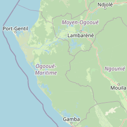
Map view of Zone humide de Petit Loango

Use this park location map to pinpoint Zone humide de Petit Loango in Gabon, understand its exact geographic position, and read its mapped placement within the surrounding landscape more clearly.

Pigeon | © OpenStreetMap contributors

Location context for Zone humide de Petit Loango

Ogooué-Maritime
Park atlas

Compare regional protected landscapes and coastal wetland reserves

Other Parks and Protected Areas Near Zone humide de Petit Loango

Continue exploring other parks near Zone humide de Petit Loango to compare surrounding coastal wetlands and protected forest reserves. Examining adjacent regional geography provides a broader understanding of protected habitats across the Atlantic coastal basin.
National parkGabon
Mapped location lies within the park boundary#1 closest

North

Loango National Park: Gabon's Coastal Wilderness and Unique Protected Landscape

Explore savanna, forest, beach, and lagoon ecosystems in this vital national park.

Loango National Park in Gabon is a significant protected area recognized for its remarkable geographic diversity. This national park encompasses over 100 kilometers of pristine, uninhabited Atlantic coastline, rare mangrove systems, and expansive savanna plains transitioning into dense tropical forests. Its unique landscape, particularly the Iguéla Lagoon, offers rich opportunities for atlas-style exploration of coastal ecosystems and protected areas. Understanding the park's mapped boundaries and regional setting is key to appreciating its ecological importance.

Area
1,550 km²
Established
2002
IUCN
II
Relief
Lowland
National parkGabon
About 92 km away#2 closest

East

Moukalaba-Doudou National Park: Protected Forest and Savanna Mosaic in Southeastern Gabon

Geographic overview of a key Central African protected area.

Moukalaba-Doudou National Park represents a significant protected area in southeastern Gabon, covering 4,500 square kilometers of diverse terrain. The park is defined by its unusual interaction between humid tropical rainforest and expansive savanna grasslands, marking it as a critical ecological transition zone in the Congo Basin region.

Area
4,500 km²
IUCN
II
Scope
Terrestrial
Water
Minor water
National parkGabon
About 92 km away#3 closest

East

Moukalaba-Doudou National Park: Geographic Context and Protected Landscape Map in Gabon

A vital tropical forest protected area in Central Africa

Moukalaba-Doudou National Park functions as a core component of the Gabon protected landscape, shielding vast tracts of tropical forest and supporting essential environmental integrity. This geographic overview provides clear insights into the park footprint and regional setting, enabling a deeper awareness of how this territory sits within the broader conservation geography of Central Africa.

Access
Access unknown
Wildlife reserveEstuaire
About 164 km away#4 closest

North

Réserve de Wonga Wongué: Atlantic Coastal Protected Landscape and Wildlife Map

Explore the geography of Gabon's expansive lowland coastal reserve

Examine the geographic boundaries and protected landscape of Réserve de Wonga Wongué, a crucial site in Gabon that features a blend of forest, hill, and plateau terrain. This reserve provides a comprehensive look at coastal river systems, marshes, and the habitats of central African megafauna along the Atlantic shore, highlighting its role as a Ramsar Wetland of International Importance and its evolving identity as a conservation area.

Area
4,281 km²
Established
1972
National parkGabon
About 185 km away#5 closest

Northeast

Waka National Park: A Mapped Protected Landscape in Gabon's Geography

Explore the natural terrain and park boundaries of this national park.

Waka National Park in Gabon represents a vital protected landscape for geographic exploration. This dedicated detail page offers insight into the park's specific mapped area and its place within the country's broader natural terrain. Understand its context as a national park, contributing to the atlas of protected areas in Central Africa. Discover the geographic identity of this significant natural reserve.

Area
1,060 km²
Established
2002
IUCN
II
Relief
Mountain
National parkGabon
About 228 km away#6 closest

Southeast

Mayumba National Park: Gabon's Equatorial Protected Area and Geographic Atlas

Explore mapped park boundaries and regional landscape context.

Delve into the geographic identity of Mayumba National Park, a significant protected area situated in Gabon. This detail page provides atlas-style insights into the park's mapped boundaries, its position within the equatorial geography of Central Africa, and its role as a national park. Understand the protected landscape's environmental context and its atlas significance.

Area
870 km²
Established
2002
IUCN
II
Relief
Lowland
Watercolor painting of a landscape with grassy areas, a lake, and distant hills under a light sky
National parkGabon
About 242 km away#7 closest

Northeast

Lopé National Park: Gabon's Protected Landscape and National Park Geography

Explore mapped boundaries and natural terrain in Central Africa.

Delve into Lopé National Park, a designated national park situated in Gabon. This protected area serves as a crucial point for understanding the nation's geography and the distribution of its conservation landscapes. As an entry in the MoriAtlas, it offers a detailed view of its mapped territory and its contribution to the broader regional context of Central Africa, emphasizing its role in protected area atlas exploration.

Area
4,910 km²
Established
2002
IUCN
II
Relief
Mixed relief
National parkGabon
About 249 km away#8 closest

North

Pongara National Park: Protected Landscape and Geographic Exploration in Gabon

Mapped boundaries and regional natural context.

Pongara National Park is a designated national park within Gabon, offering a unique opportunity for structured exploration of protected lands. Users can investigate its specific geographic setting, understand its mapped boundaries, and appreciate its place within the regional landscape context. This entry provides a factual foundation for understanding the park's identity as a protected natural area and its contribution to Gabon's geography.

Area
929 km²
Established
2002
IUCN
II
Relief
Lowland

Common questions about visiting, size, designation, and location context for Zone humide de Petit Loango

Zone humide de Petit Loango FAQs for park facts, access, geography, and protected area context

Find quick answers about Zone humide de Petit Loango, including protected-area facts, park geography, trail and visitor context, and how the park fits into its surrounding country and regional landscape.
MoriAtlas Explorer

Continue Your Protected Areas Search Across the Global Atlas

Deepen your exploration by continuing the structured search for national parks and protected areas worldwide. Utilize the comprehensive filtering capabilities to compare different conservation landscapes and refine your understanding of global park geography. Discover more about the distribution and characteristics of protected natural areas.

Global natural geography