
Islands
Park geography
A structured look at landscape features, regional extent, and coastal terrain.
Geographic Profile and Mapped Boundaries of Finland's Archipelago National Park
Review the geographic framework of Archipelago National Park, which covers a recorded area of 500 square kilometers within Southwest Finland. This profile maps the park's coastal terrain, lowland relief, and marine island features, providing a complete spatial analysis of its diverse environment.
Finland's island wilderness in the Archipelago Sea
Archipelago National Park
Archipelago National Park is a protected wilderness area in Southwest Finland, established in 1983 to preserve the unique ecological and cultural character of the Finnish Archipelago Sea. The park covers approximately 500 square kilometers of land spread across thousands of islands, skerries, and islets, making it one of Finland's most extensive coastal protected areas. Unlike typical mainland national parks, this park is fundamentally defined by its marine environment and the intricate archipelago landscape of shallow waters, rocky islands, and sheltered bays that have shaped both the natural ecosystems and human communities here for millennia. The park encompasses roughly 2,000 of the 8,400 islands within its cooperative area, though most land lies on islands smaller than one square kilometer. The landscape represents a dynamic environment shaped by post-glacial rebound, where the land continues to rise at a rate of 3 to 4.2 millimeters per year. This ongoing geological process means the archipelago is literally constantly evolving, with new islands emerging while existing ones expand. The park forms part of a broader UNESCO biosphere reserve and received PAN Parks certification in 2007, recognizing both its ecological significance and its sustainable approach to management. What distinguishes Archipelago National Park from other Finnish protected areas is its dual commitment to preserving both natural habitats and the cultural landscape shaped by centuries of human habitation. The cooperative area extends beyond the core protected zone to include inhabited islands where traditional agriculture and fishing continue, recognizing that the archipelago's cultural heritage is inseparable from its ecological value.
- Location
- Finland
- Park type
- National park
- Established
- 1983
- Area
- 500 km²
Location overview
Mapped regional placement and coastal island characteristics
Geographic Setting of Archipelago National Park in Finland
Archipelago National Park is situated within Southwest Finland in the nation of Finland. Factual atlas records classify the protected reserve as a coastal, island, and marine park.
- Countries
- Finland
- Regions
- Southwest Finland
- Primary location
- Finland
- Geographic setting
- Coastal · Island · Marine
Boundary and coordinates
Mapping five hundred square kilometers of protected terrestrial territory
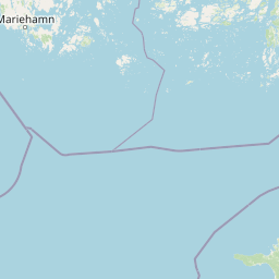
Archipelago National Park Boundary Map and Geographic Limits
Detailed geometric outlines offer essential spatial context for the complex outer reaches of the protected territory. Integrated geographic datasets clarify the estimated terrestrial area, coordinate limits, and regional span.
- Boundary area
- 526.1 km²
- Boundary perimeter
- 1,091.8 km
- Northernmost point
- 60.1788° N
- Southernmost point
- 59.6685° N
- Easternmost point
- 22.7743° E
- Westernmost point
- 21.0238° E
- Geographic centre
- 59.8914° N, 21.8657° E
- North–south span
- 56.8 km
- East–west span
- 97.9 km
Terrain and natural features
Explore recorded island formations, straits, and coastal wetlands within the park
Archipelago National Park Terrain Geography and Named Natural Features
Recorded terrain classifications outline the lowland landscape profile across protected islands, straits, and lagoons. Linked feature cards supply official names, types, and spatial relationships for each mapped natural formation.
Selected named natural features
Islands
Lilla Stubbskär
Islands
Södra Rönnharun
Islands
Stickelskären
Straits
Skiftet
Islands
Klöverharun
Environmental setting
Temperate lowland climate zones and coastal marine habitats across islands
Archipelago National Park Environmental Settings and Mapped Classifications
Recorded landscape features, habitat types, and seasonal classifications function as broad interpretive categories for the physical setting. Linked entries connect these recorded environmental properties directly to relevant regional atlas destinations.
- Relief
- Lowland
- Climate
- Temperate
- Water
- Major water bodies
- Seasonality
- Seasonal
Landscape features
Islands · Coast · Grassland
Habitat types
Coastal habitat · Marine habitat · Grassland
Park atlas
Trace the broader geographic context of Finland's protected areas, comparing Archipelago National Park with other Nordic conservation landscapes.
Discover Other National Parks and Protected Areas Near Archipelago National Park in Finland
Explore national parks and protected areas geographically relevant to Archipelago National Park, tracing Finland's diverse coastal ecosystems and surrounding Nordic conservation landscapes. Compare the unique maritime environment of the archipelago with other protected areas to understand regional park geography and conservation patterns across Northern Europe.
National parkSouthwest Finland
About 35 km away#1 closest
Northeast

Teijo National Park: Mapped Boundaries of a Protected National Park in Southwest Finland
Explore the geographic context and protected landscape of Teijo National Park.
Teijo National Park is a designated national park within Southwest Finland, offering a distinct protected landscape for atlas exploration. This entry focuses on its geographic identity, mapped park boundaries, and its place within the broader regional geography. Discover the structured details of Teijo National Park as a key protected area, providing valuable context for understanding natural landscapes and conservation efforts in Finland.
- Area
- 34 km²
- Established
- 2015
- IUCN
- II
- Visitors
- 92.1K annual
National parkUusimaa
About 38 km away#2 closest
East
Ekenäs Archipelago National Park: Mapped Baltic Sea Archipelago Landscape
Protected marine area with island geography in Uusimaa, Finland.
Delve into the unique protected landscape of Ekenäs Archipelago National Park, a premier example of a Baltic Sea marine protected area. Located in the Uusimaa region, this national park encompasses a vast expanse of coastal waters dotted with hundreds of rocky islets and skerries. MoriAtlas provides detailed geographic context, allowing for exploration of its mapped boundaries, island formations, and critical role as a sanctuary for breeding aquatic birds. Understand its place within Finland's protected areas atlas and appreciate its distinctive marine archipelago character.
- Area
- 52 km²
- Established
- 1989
- IUCN
- II
- Visitors
- 53.6K annual
National parkSouthwest Finland
62 km away#3 closest
North
Kurjenrahka National Park: Southwest Finland's Protected Landscape Atlas Entry
Discover geographic context and park boundaries.
Delve into Kurjenrahka National Park, a designated national park situated in Southwest Finland. This page provides an atlas-focused view of the park, detailing its protected landscape identity, mapped terrain, and its specific geographic location within the broader Finnish region. Understand the park's ecological context and its significance as a key protected area for regional geographic exploration.
- Area
- 29 km²
- Established
- 1998
- IUCN
- II
- Visitors
- 66.8K annual
National parkSouthwest Finland
About 92 km away#4 closest
North
Bothnian Sea National Park: Southwest Finland's Coastal Protected Landscape
Mapped geography and regional protected area context.
Bothnian Sea National Park stands as a significant protected landscape situated within the extensive island formations of Southwest Finland's Archipelago Sea. This page provides an atlas-focused view of the national park, detailing its geographic spread, mapped boundaries, and its place within the regional context of Varsinais-Suomi. Understand the protected area's unique coastal identity and its contribution to the mapped natural terrain of southern Finland, facilitating structured discovery and geographic exploration.
- Area
- 917 km²
- Established
- 2011
- IUCN
- II
- Visitors
- 79.4K annual
National parkKanta-Häme
95 km away#5 closest
Northeast
Torronsuo National Park: Explore Finland's Exceptional Raised Bog Ecosystem and Kanta-Häme Geography
Discover mapped peatlands, unique birdlife, and protected boreal wilderness.
Torronsuo National Park stands as a testament to Finland's remarkable wetland conservation efforts, presenting a striking example of a raised bog ecosystem. Located within the Kanta-Häme region, this national park is celebrated for its vast, domed peat landscape, some of the thickest peat layers ever measured in Finland, and its status as a Ramsar-designated wetland. The park's protected status ensures the preservation of its unique natural terrain, which supports a rich diversity of northern bird species and specialized bog flora, making it a significant area for ecological and geographic exploration.
- Area
- 25.5 km²
- Established
- 1990
- IUCN
- II
- Visitors
- 58.6K annual
National parkKanta-Häme
100 km away#6 closest
Northeast
Liesjärvi National Park: Protected Landscape in Kanta-Häme's Finnish Lakeland
Explore its mapped geography and protected area context.
Liesjärvi National Park is a designated national park situated in the Kanta-Häme region, a landscape rich with the characteristic features of southern Finland's Finnish Lakeland. This page serves as a focused entry point for understanding the park's protected status, its unique geographic setting, and its contribution to the regional atlas of natural landscapes. By examining Liesjärvi National Park, users gain insight into the mapped terrain and conservation efforts that define this part of Finland, fostering a deeper appreciation for protected areas.
- Area
- 22 km²
- Established
- 1956
- IUCN
- II
- Visitors
- 57.3K annual
National parkLääne County
104 km away#7 closest
Southeast

Matsalu National Park: Explore Estonia's Premier Wetland National Park Geography and Protected Area
Discover mapped landscapes and bird migration routes in Lääne County.
Matsalu National Park, located in Lääne County, Estonia, is a prime example of a protected wetland ecosystem of international significance. This page delves into the park's unique geographic features, including the shallow brackish Matsalu Bay, the expansive Kasari River delta, and the numerous islands that form its coastal mosaic. Users can explore the park's protected boundaries and understand its critical function as a major staging area for migratory birds, offering a detailed atlas-level view of this important natural landscape.
- Area
- 486.1 km²
- Established
- 1957
- IUCN
- II
- Relief
- Lowland
National parkUusimaa
108 km away#8 closest
East
Nuuksio National Park: Uusimaa Region Protected Landscape Atlas Entry
Mapped boundaries and geographic context for a Finnish National Park.
Access detailed geographic information and mapped boundaries for Nuuksio National Park, a protected national park within the Uusimaa region. This MoriAtlas entry provides context for understanding its landscape within Finland, focusing on atlas-style exploration and the identification of protected natural areas.
- Area
- 53 km²
- Established
- 1994
- IUCN
- II
- Visitors
- 312.6K annual
MoriAtlas Explorer
Continue exploring Archipelago National Park's mapped geography and protected landscape identity
Further your atlas exploration by delving into the specific mapped boundaries and geographic details of Archipelago National Park. Understanding this protected landscape's place within Finland's regional geography enriches your appreciation of its natural terrain and conservation significance. Utilize MoriAtlas to navigate from this park to surrounding natural areas and gain a comprehensive view of protected lands.
Browse next
Global natural geography
Explore related park routes
Explore MoriAtlas Global ParksBrowse All MoriAtlas ParksGlobal Park Map DiscoveryMoriAtlas: Browse All CountriesBrowse All MoriAtlas ContinentsNational Park Environment AtlasGrand Canyon National Park AtlasYellowstone National Park AtlasYosemite National Park Atlas and GeographySerengeti National Park AtlasGalápagos National Park Protected LandscapeBanff National Park Geography and AtlasKruger National Park Atlas EntryUluṟu-Kata Tjuṯa National Park AtlasExplore Uluru-Kata Tjuta National Park GeographyPlitvice Lakes National Park AtlasFiordland National Park Protected LandscapeGreat Smoky Mountains National Park AtlasAfghanistan National Parks and Protected AreasAlbania National Parks and Protected AreasAlgeria National Parks and Protected AreasAmerican Samoa National Parks and Protected AreasAndorra National Parks and Protected AreasAngola National Parks and Protected AreasAntarctica National Parks and Protected AreasAntigua and Barbuda Park List