Peaks
Co Aragay
365 m

Regional landscape context, elevation data, and physical coordinates for Chilean protected lands
This geographic profile details the physical characteristics of Cabo de Hornos National Park in the Magallanes y Antártica Chilena Region. The record includes specific boundary metrics, elevation ranges spanning from 220 to 670 meters, and a catalog of natural features such as Cerro Cloven, the Drake Passage, and coastal cape environments.
Related tags
The world's southernmost national park, protecting the legendary Cape Horn Archipelago in Chilean Patagonia
Cabo de Hornos National Park is the southernmost national park in the world, encompassing the dramatic Cape Horn Archipelago in the extreme south of Chile. The park protects a vast stretch of islands and islets in the Beagle Channel and southern Drake Passage, including the Wollaston Islands and Hermite Islands. Established in 1945 and later designated a UNESCO Biosphere Reserve in 2005, this remote protected area spans approximately 63,000 hectares of sub-Antarctic ecosystems characterized by treeless peatlands, Magellanic forests, and rugged island terrain. The park holds exceptional significance as both a geographic landmark representing the southernmost point of the Americas and a biodiversity hotspot supporting remarkable populations of seabirds and marine mammals. Access is exclusively by boat, with the park lying about 12 hours maritime travel from Puerto Williams, the nearest settlement.
Island and coastal geography within Magallanes y Antártica Chilena
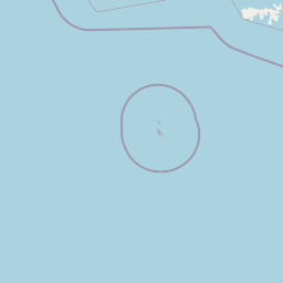
Map representation and spatial limits covering over 630 square kilometers
Lowland relief classification, elevation span, and recorded natural features
Peaks
365 m
Peaks
262 m
Capes
Straits
Capes
Peaks
575 m
Subpolar climate, sparse forest cover, and coastal tundra habitats
Islands · Coast · Bog · Grassland · Tundra
Boreal forest · Peatland · Grassland · Tundra habitat · Coastal habitat · Marine habitat
Compare surrounding protected landscapes and trace the unique island geography across the region.
Northwest

Explore a protected national park in Chile's Magallanes Region.
Alberto de Agostini National Park is a significant protected area within the Magallanes Region, defined by the dramatic southern extent of the Andes, including the iconic Cordillera Darwin. This national park is characterized by extensive tidewater glaciers, deep fjords, and unique subpolar forests, offering a profound example of glacial landscape formation. Understanding its geographic setting and mapped boundaries provides critical context for exploring this remote Patagonian wilderness and its ecological significance.
Southwest
Explore its remote island geography and vital Drake Passage marine ecosystems.
This national park protects one of the world's most remote and ecologically significant subantarctic environments, safeguarding the Diego Ramírez Islands and the legendary Drake Passage. It covers over 14 million hectares, representing Chile's southernmost contribution to global marine conservation and protecting unique pelagic bird habitats, marine mammal feeding grounds, and distinctive submarine geomorphology including Sars Seamount. The park's landscape is characterized by harsh subantarctic conditions, with vegetation adapted to cold, windy environments, and unique seafloor terrain beneath the powerful Antarctic Circumpolar Current.
North

Explore the mapped terrain and subantarctic geography of this vital protected area.
Tierra del Fuego National Park, located at the southern tip of South America, provides a crucial atlas perspective on subantarctic ecosystems. This protected national park encompasses dramatic glacial valleys, rugged mountain ranges, ancient beech forests, and a significant coastal area along the Beagle Channel. Its unique landscape, accessible from Ushuaia, offers rich opportunities for understanding regional geography and the distribution of protected lands at the continent's edge.
Northwest
Mapped geographic context and protected area discovery.
Yendegaia National Park in Tierra del Fuego, Chile, stands as a distinct protected area offering valuable insights into regional geography and landscape. This page serves as a focused entry point for understanding the park's mapped boundaries and its significance as a national park. Delve into the specific geography and protected natural landscape that defines Yendegaia National Park within the broader South American atlas context.
Northwest
Explore the mapped geography and protected area boundaries.
Kawésqar National Park is a key national park entity situated within the Magallanes and Chilean Antártica Region, contributing to the protected landscape of southern Chile. This atlas-focused profile details the park's geographic scope and its significance as a designated protected area. It serves as an entry point for understanding the mapped terrain and regional park context, crucial for structured geographic discovery.
North
Explore the geographic context and park boundaries in Chile.
Examine Pali-Aike National Park as a distinct protected landscape within Chile. This entry offers a detailed atlas perspective, focusing on its mapped boundaries, regional geographic setting, and the specific character of its natural terrain. Understand its significance as a national park and a point of interest for geographic discovery.
East
A vital oceanic landscape in the South Atlantic
Burdwood Bank is a prominent submerged plateau situated 200 kilometres south of the Falkland Islands. As an essential marine protected area, it features dramatic bathymetric relief, with steep slopes and a shallow summit that forces the Antarctic Circumpolar Current to create intense upwelling zones. This unique configuration supports high marine productivity, acting as a natural nursery and spawning ground for significant Southern Atlantic fish and wildlife populations.
North
Explore its unique sandstone formations and rich marine geography.
Monte León National Park stands as a significant federal protected area along Argentina's Patagonian coast. Known for its dramatic sandstone cliffs, including the iconic Monte Cabeza de León, and extensive Magellanic penguin colonies, this park offers a unique glimpse into coastal ecosystems. Its designation as Argentina's first continental marine park highlights its importance for biodiversity and landscape conservation along the southern Argentine Sea shoreline, providing rich context for atlas exploration.
Dive deeper into the structured geographic data for Cabo de Hornos National Park, understanding its specific mapped boundaries and its role within the broader Magallanes y Antártica Chilena Region. This park detail page serves as a key entry point for those who want to map and comprehend protected landscapes with precision. Continue your atlas exploration by examining the unique geographic context that defines this significant national park.