

Mori Atlas logo
National parkCabo de Hornos National Park

Discover the mapped boundaries and regional context of this protected area in Magallanes y Antártica Chilena Region.

Cabo de Hornos National Park: National Park Protected Landscape and Geography

(Parque Nacional Cabo de Hornos)

Cabo de Hornos National Park represents a significant protected landscape within Chile's Magallanes y Antártica Chilena Region. As a national park, its primary identity is rooted in conservation and the preservation of its unique geographic features. This page offers an atlas-centric view, detailing the park's mapped boundaries and its relationship to the surrounding regional geography, providing essential context for understanding its place in the natural world.

sub-Antarctic ecosystemsislandsMagellanic forestspeat bogsseabird coloniesUNESCO Biosphere Reserve

Cabo de Hornos National Park

National park

Park overview

Structured park overview, official facts, and landscape profile for Cabo de Hornos National Park

Cabo de Hornos National Park park facts, protected area profile, and essential visitor context

Review the core facts for Cabo de Hornos National Park, including designation, size, terrain, visitor scale, habitats, and operating context in one park-focused overview.

About Cabo de Hornos National Park

Cabo de Hornos National Park occupies a unique position at the very edge of the inhabited world, protecting the legendary Cape Horn Archipelago that marks the southernmost point of South America. The park comprises a complex mosaic of islands, islets, and maritime environments in the Beagle Channel and adjacent waters of the Drake Passage. This remote territory belongs to the Commune of Cabo de Hornos in the Antártica Chilena Province of the Magallanes y Antártica Chilena Region of Chile. The landscape is characterized by treeless peat bogs, wind-shaped vegetation, and scattered enclaves of Magellanic forest in sheltered valleys and ravines. The islands generally rise to modest elevations of 200 to 220 meters above sea level, with only two significant peaks breaking the otherwise low profile: Cerro Pirámide at 406 meters on Hornos Island and Cerro Hyde at approximately 670 meters on Wollaston Island. The park's significance extends beyond its geographic extremity; it serves as a critical conservation unit for sub-Antarctic ecosystems and hosts globally important populations of seabirds and marine mammals. The region experiences a harsh sub-Antarctic climate with persistent strong winds, high rainfall, and limited sunshine, creating conditions that have shaped distinctive ecological communities adapted to this extreme environment.

Quick facts and research context for Cabo de Hornos National Park

Cabo de Hornos National Park covers 63,093 hectares across the Cape Horn Archipelago in Chile's Magallanes Region. The park was established on April 26, 1945, and is administered by CONAF (Corporación Nacional Forestal). It forms part of the larger Cabo de Hornos Biosphere Reserve, designated by UNESCO in 2005. The archipelago sits at approximately 55°50′S, making it the southernmost protected area in Chile except for the Chilean Antarctic Territory. The landscape is dominated by low-lying islands reaching elevations between 200 and 670 meters, with the highest point being Cerro Hyde on Wollaston Island.

Protection and recognition

Documenting terrestrial conservation boundaries and official UNESCO biosphere designation

Cabo de Hornos National Park Protection Status and International Recognition

Established terrestrial boundaries define the conservation framework of Cabo de Hornos National Park in southern Chile. Official records trace the geographic scope of the park alongside its international recognition as part of a UNESCO Biosphere Reserve.

International recognition

Protection details

Protection scope
Terrestrial
Designated year
2005
Transboundary protection
No
Core area
17,035.1 km²
Buffer area
17,113.18 km²
Park context

Deeper park guide and search-rich context for Cabo de Hornos National Park

Cabo de Hornos National Park history, landscape, wildlife, and travel context

Explore Cabo de Hornos National Park through its history, landscape character, ecosystems, wildlife, conservation priorities, cultural context, and seasonal travel timing in a structured park guide built for atlas discovery and search intent.

Why Cabo de Hornos National Park stands out

Cabo de Hornos National Park is best known as the world's southernmost national park, protecting the legendary Cape Horn region that has captured the imagination of mariners for centuries. The park is renowned for its exceptional seabird colonies, particularly Magellanic penguins, southern royal albatrosses, and the southern giant petrel. Its designation as an Important Bird Area by BirdLife International underscores the global significance of its avian populations. The park also protects the southernmost forests in the world, including the northernmost individual of Nothofagus betuloides documented on Hornos Island, representing a critical biogeographic boundary.

Cabo de Hornos National Park history and protected-area timeline

The region of Cabo de Hornos was discovered by the Dutch merchant Isaac Le Maire on January 29, 1616, who named the area Hoorn after the Dutch city from which the expedition originated. For centuries, Cape Horn served as one of the most legendary and treacherous navigation points in maritime history, marking the gateway between the Atlantic and Pacific Oceans. The national park was formally created on April 26, 1945, by decree of the Chilean Ministry of Agriculture, making it one of Chile's older protected areas. In 2005, the park was designated as a Biosphere Reserve by UNESCO, recognizing its exceptional ecological value and establishing it as part of a broader conservation framework that includes the neighboring Alberto de Agostini National Park. The creation of the biosphere reserve reflected growing understanding of the region's global significance for biodiversity conservation and the need to coordinate protection efforts across the Cape Horn archipelago.

Cabo de Hornos National Park landscape and geographic character

The landscape of Cabo de Hornos National Park is defined by its island geography and sub-Antarctic character. The park protects a sprawling archipelago of islands and islets, with the two main groups being the Wollaston Islands and Hermite Islands. These islands rise from the sea as relatively low, rounded landforms with elevations generally ranging from 200 to 220 meters above sea level. The terrain is dominated by extensive peat bogs and heath vegetation, with the almost complete absence of trees being a striking feature of the islands. Only in protected ravines and valleys do small patches of Magellanic forest occur, featuring species such as Antarctic beech, lenga, winter's bark, and Magellanic coigüe. The highest points in the park are Cerro Pirámide on Hornos Island at 406 meters and the more imposing Cerro Hyde on Wollaston Island at approximately 670 meters, the latter representing the most significant elevation in the protected area. The coastline is rugged and exposed, with dramatic transitions between rocky shores and peaty slopes. The maritime setting places the islands at the mercy of the notorious winds of the southern Drake Passage, creating a landscape shaped by persistent strong winds and salt spray.

Cabo de Hornos National Park ecosystems, habitats, and plant life

The natural environment of Cabo de Hornos National Park represents one of the world's southernmost terrestrial ecosystems, characterized by a distinctive sub-Antarctic flora adapted to extreme conditions. The park protects a complex mosaic of habitats including Magellanic forests, peat bogs, wind-exposed shrublands, and coastal tundra. In the island's ravines and slopes, forests of Nothofagus species dominate, including coihue de Magallanes, lenga, and ñirre, alongside canelo (Drimys winteri). The extensive peat bogs are dominated by Sphagnum moss, known locally as pompón, which plays a critical role in carbon storage and represents a globally significant ecosystem type. The region is recognized as a world hotspot for cryptogams, concentrating an exceptional proportion of global bryophyte and lichen diversity in a remarkably small area. The park sits at a critical biogeographic boundary, with Hornos Island hosting the world's southernmost documented tree specimen, a Nothofagus betuloides that represents a significant milestone in understanding the climatic limits of forest ecosystems.

Cabo de Hornos National Park wildlife and species highlights

The wildlife of Cabo de Hornos National Park is dominated by seabirds and marine mammals that thrive in the productive waters surrounding the archipelago. The park has been designated an Important Bird Area by BirdLife International due to its significance for breeding seabird populations. Key avian species include Magellanic penguins, which nest in coastal colonies along the island shores, the impressive southern royal albatross, southern giant petrels, kelp gulls, and red-legged cormorants. The park also supports significant populations of southern rockhopper penguins, sooty shearwaters, blackish cinclodes, and the striking striated caracara. Marine mammals are well-represented in the surrounding waters, with the marine otter (locally called chungungo) found along the coast, while the open waters host leopard seals, Chilean dolphins (tonina), Burmeister's porpoises, Peale's dolphins, and seasonal humpback whales that migrate through the region. The combination of productive marine ecosystems and relatively undisturbed terrestrial habitats makes this one of the most significant wildlife areas in southern South America.

Cabo de Hornos National Park conservation status and protection priorities

Cabo de Hornos National Park plays a critical role in protecting one of the world's most southerly terrestrial ecosystems and the surrounding marine environment. The park's designation as a UNESCO Biosphere Reserve in 2005 reflects its global significance for biodiversity conservation. The protection of the Cape Horn Archipelago is particularly important given the region's position as a major biogeographic transition zone and its exceptional concentrations of cryptogam diversity. However, the park faces significant conservation challenges from invasive species introduced during the twentieth century, including North American beavers, American minks, and muskrats, which have altered riparian forests, wetlands, and nesting bird communities. Conservation efforts within the broader Cabo de Hornos Biosphere Reserve include monitoring and control programs targeting these invasive species. The park also contributes to the protection of globally significant seabird populations and serves as a reference site for understanding sub-Antarctic ecosystem dynamics.

Cabo de Hornos National Park cultural meaning and human context

Cabo de Hornos holds profound significance in maritime history as one of the most legendary navigation points on Earth. For centuries, the Cape Horn route represented the primary passage between the Atlantic and Pacific Oceans before the Panama Canal was completed, and the passage through these storm-bound waters earned a fearsome reputation among sailors. The region was discovered by Dutch explorer Isaac Le Maire in 1616, who named the area after his hometown of Hoorn. The park contains a monument to the albatross on Hornos Island, a symbolic tribute to the bird that has long been associated with this remote region and the sailors who navigated its waters. The nearest settlement, Puerto Williams, serves as the gateway for park access and represents one of the southernmost inhabited places in the world. The area's cultural heritage is inseparable from its geographic identity as the southernmost point of the Americas.

Top sights and standout views in Cabo de Hornos National Park

Cabo de Hornos National Park offers access to one of the most remote and symbolically significant landscapes on Earth. Visitors can explore the islands of the Cape Horn Archipelago, walk among colonies of Magellanic penguins, and witness the dramatic windswept terrain that has shaped both the ecosystem and the region's maritime legend. The albatross monument on Hornos Island stands as a testament to the site's cultural importance and the profound connection between this place and the seafaring tradition. The park provides exceptional opportunities to observe southern seabirds including the impressive southern royal albatross, and to encounter marine mammals in the surrounding waters. As the world's southernmost national park, a visit here represents a journey to the edge of the inhabited world, offering a profound sense of remoteness and geographical extremity.

Best time to visit Cabo de Hornos National Park

The most favorable conditions for visiting Cabo de Hornos National Park occur during the austral summer months from October through April, when temperatures are relatively milder and daylight hours are longest. This period corresponds with the breeding season for many seabird species, including penguins and albatrosses, offering optimal wildlife viewing opportunities. The summer months also bring reduced wind speeds compared to the winter season, when gale-force winds occur up to 30% of the time and visibility is frequently poor. Summer visitors can expect cool temperatures typical of sub-Antarctic conditions, persistent cloud cover, and the likelihood of encountering rain at any time. The remote nature of the park means that visits are weather-dependent, and boat access from Puerto Williams requires favorable sea conditions.
Monthly climate preview

Trace long-term representative temperature and monthly precipitation averages

Cabo de Hornos National Park Climate Normals and Annual Weather Rhythm

Representative coordinate records show measured multi-year temperature variations and steady daily precipitation patterns across the annual cycle for Cabo de Hornos National Park. Accessing the complete monthly climate profile reveals detailed twelve-month statistics for deeper analytical comparison.
Annual mean6 °C
4 °C8 °C
Jan
Feb
Mar
Apr
May
Jun
Jul
Aug
Sep
Oct
Nov
Dec
Warmest month
February

8.1 °C

Coolest month
July

3.9 °C

Wettest month
March

3.7 mm/day

Driest month
September

2.6 mm/day

Park location guide

Geography guide, regional context, and park location map for Cabo de Hornos National Park

Cabo de Hornos National Park park geography, regions, and map view in Chile

Understand where Cabo de Hornos National Park sits in Chile through a broader geographic reading of the surrounding landscape, nearby location context, and its mapped position within the national park landscape.

How Cabo de Hornos National Park fits into Chile

Chile is a presidential republic in western South America, extending as a narrow strip along the western edge of the continent between the Andes Mountains and the Pacific Ocean. It is the southernmost country in the world and the closest to Antarctica. The country is bordered by Peru, Bolivia, and Argentina, and administers several Pacific islands including Easter Island. Chile is a major copper producer and has a population of approximately 19.6 million.

Wider geography shaping Cabo de Hornos National Park in Chile

Chile occupies a narrow strip of land along the western edge of South America, extending approximately 4,300 km north to south but only about 350 km east to west at its widest point. The country is sandwiched between the Andes Mountains to the east and the Pacific Ocean to the west. It shares borders with Peru to the north, Bolivia to the northeast, and Argentina to the east. Southern Chile borders the Drake Passage. Chile also administers several Pacific islands including Juan Fernández Islands, Isla Salas y Gómez, Desventuradas Islands, and Easter Island, plus the Chilean Antarctic Territory.

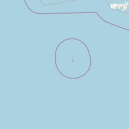
Map view of Cabo de Hornos National Park

Use this park location map to pinpoint Cabo de Hornos National Park in Chile, understand its exact geographic position, and read its mapped placement within the surrounding landscape more clearly.

Pigeon | © OpenStreetMap contributors

Location context for Cabo de Hornos National Park

Cabo de HornosMagallanes y Antártica Chilena Region
Natural feature types

Trace the Diverse Natural Features of Cabo de Hornos National Park

Continue your geographic discovery by exploring the named landmarks and terrain types within this remote protected area. MoriAtlas provides a structured view of the islands, wetlands, and forests that define the rugged Cabo de Hornos National Park environment.
Recorded earthquake history

Explore the Historical Earthquake Catalogue for Cabo de Hornos National Park

Review recorded seismic activity and event data for the islands and marine landscapes surrounding the park. This MoriAtlas collection provides a transparent view of historical earthquake records to support deeper geographic exploration of the southern Chilean archipelago.

Cabo de Hornos National Park Earthquake Records

Catalogued events

1 event

Strongest magnitude

Magnitude 4

Most recent event

Nov 10, 2025

This history includes earthquakes recorded inside the park or within 50 km of its borders

Park atlas

Compare surrounding protected landscapes and trace the unique island geography across the region.

Other National Parks Near Cabo de Hornos: Explore Southernmost Chilean Protected Areas

Continue your exploration from Cabo de Hornos National Park by browsing other protected areas and national parks in the surrounding sub-Antarctic region of southern Chile. Compare diverse landscapes, island ecosystems, and conservation efforts to deepen your understanding of this unique part of the world's geography.
National parkMagallanes Region
48 km away#1 closest

Northwest

Alberto de Agostini National Park: Glacial Landscapes and Cordillera Darwin Geography

Explore a protected national park in Chile's Magallanes Region.

Alberto de Agostini National Park is a significant protected area within the Magallanes Region, defined by the dramatic southern extent of the Andes, including the iconic Cordillera Darwin. This national park is characterized by extensive tidewater glaciers, deep fjords, and unique subpolar forests, offering a profound example of glacial landscape formation. Understanding its geographic setting and mapped boundaries provides critical context for exploring this remote Patagonian wilderness and its ecological significance.

Area
14,600 km²
Established
1965
IUCN
II
Relief
Mountain
National parkMagallanes y la Antártica Chilena Region
50 km away#2 closest

Southwest

Diego Ramírez Islands and Drake Passage National Park: A Southern Ocean Protected Landscape

Explore its remote island geography and vital Drake Passage marine ecosystems.

This national park protects one of the world's most remote and ecologically significant subantarctic environments, safeguarding the Diego Ramírez Islands and the legendary Drake Passage. It covers over 14 million hectares, representing Chile's southernmost contribution to global marine conservation and protecting unique pelagic bird habitats, marine mammal feeding grounds, and distinctive submarine geomorphology including Sars Seamount. The park's landscape is characterized by harsh subantarctic conditions, with vegetation adapted to cold, windy environments, and unique seafloor terrain beneath the powerful Antarctic Circumpolar Current.

Area
144,391 km²
Established
2025
IUCN
II
Climate
Subpolar
Watercolor illustration of a lake with mountains and greenery under a pink-hued sky
National parkArgentina
85 km away#3 closest

North

Tierra del Fuego National Park: Southernmost Argentinian National Park and Protected Landscape

Explore the mapped terrain and subantarctic geography of this vital protected area.

Tierra del Fuego National Park, located at the southern tip of South America, provides a crucial atlas perspective on subantarctic ecosystems. This protected national park encompasses dramatic glacial valleys, rugged mountain ranges, ancient beech forests, and a significant coastal area along the Beagle Channel. Its unique landscape, accessible from Ushuaia, offers rich opportunities for understanding regional geography and the distribution of protected lands at the continent's edge.

Area
630 km²
Established
1960
IUCN
II
Relief
Mountain
National parkTierra del Fuego
92 km away#4 closest

Northwest

Yendegaia National Park: A Chilean Protected Landscape within Tierra del Fuego

Mapped geographic context and protected area discovery.

Yendegaia National Park in Tierra del Fuego, Chile, stands as a distinct protected area offering valuable insights into regional geography and landscape. This page serves as a focused entry point for understanding the park's mapped boundaries and its significance as a national park. Delve into the specific geography and protected natural landscape that defines Yendegaia National Park within the broader South American atlas context.

Area
1,506.12 km²
Established
2013
IUCN
II
Relief
Mountain
National parkMagallanes and Chilean Antártica Region
281 km away#5 closest

Northwest

Kawésqar National Park: A National Park with Distinct Protected Landscape Identity

Explore the mapped geography and protected area boundaries.

Kawésqar National Park is a key national park entity situated within the Magallanes and Chilean Antártica Region, contributing to the protected landscape of southern Chile. This atlas-focused profile details the park's geographic scope and its significance as a designated protected area. It serves as an entry point for understanding the mapped terrain and regional park context, crucial for structured geographic discovery.

Area
28,425.3 km²
Established
1969
IUCN
IV
Visitors
1.7K annual
National parkChile
396 km away#6 closest

North

Pali-Aike National Park: Chilean Protected Area and Landscape Atlas

Explore the geographic context and park boundaries in Chile.

Examine Pali-Aike National Park as a distinct protected landscape within Chile. This entry offers a detailed atlas perspective, focusing on its mapped boundaries, regional geographic setting, and the specific character of its natural terrain. Understand its significance as a national park and a point of interest for geographic discovery.

Area
50.3 km²
Established
1970
IUCN
II
Visitors
2.5K annual
Marine protected areaArgentina
About 545 km away#7 closest

East

Burdwood Bank: Marine Protected Area and Submerged Plateau Geography

A vital oceanic landscape in the South Atlantic

Burdwood Bank is a prominent submerged plateau situated 200 kilometres south of the Falkland Islands. As an essential marine protected area, it features dramatic bathymetric relief, with steep slopes and a shallow summit that forces the Antarctic Circumpolar Current to create intense upwelling zones. This unique configuration supports high marine productivity, acting as a natural nursery and spawning ground for significant Southern Atlantic fish and wildlife populations.

Established
2013
Relief
Lowland
Access
Remote access
Scope
Marine
National parkArgentina
564 km away#8 closest

North

Monte León National Park: Patagonia's First Continental Marine Protected Area and Coastal Atlas

Explore its unique sandstone formations and rich marine geography.

Monte León National Park stands as a significant federal protected area along Argentina's Patagonian coast. Known for its dramatic sandstone cliffs, including the iconic Monte Cabeza de León, and extensive Magellanic penguin colonies, this park offers a unique glimpse into coastal ecosystems. Its designation as Argentina's first continental marine park highlights its importance for biodiversity and landscape conservation along the southern Argentine Sea shoreline, providing rich context for atlas exploration.

Area
621.68 km²
Established
2004
IUCN
II
Relief
Upland

Common questions about visiting, size, designation, and location context for Cabo de Hornos National Park

Cabo de Hornos National Park FAQs for park facts, access, geography, and protected area context

Find quick answers about Cabo de Hornos National Park, including protected-area facts, park geography, trail and visitor context, and how the park fits into its surrounding country and regional landscape.
MoriAtlas Explorer

Continue Your Protected Areas Search Across the Global Atlas

Deepen your exploration by continuing the structured search for national parks and protected areas worldwide. Utilize the comprehensive filtering capabilities to compare different conservation landscapes and refine your understanding of global park geography. Discover more about the distribution and characteristics of protected natural areas.

Global natural geography
