Mori Atlas logo
National parkChundikkulam National Park

Trace the mapped park boundaries and regional geography of this significant protected area.

Chundikkulam National Park: Sri Lanka's Protected Landscape and Geographic Atlas

Discover Chundikkulam National Park, a key protected area situated within the Northern Province of Sri Lanka. This national park serves as a vital component of the regional atlas, offering a dedicated space for exploring mapped protected land, understanding its geographic placement, and appreciating its role within the natural landscape context of the island.

Coastal WetlandsLagoon EcosystemsBird SanctuariesMangrove ForestsScrub ForestCrocodile Habitats

Chundikkulam National Park

National park

Park overview

Structured park overview, official facts, and landscape profile for Chundikkulam National Park

Chundikkulam National Park park facts, protected area profile, and essential visitor context
Review the core facts for Chundikkulam National Park, including designation, size, terrain, visitor scale, habitats, and operating context in one park-focused overview.

About Chundikkulam National Park

Chundikkulam National Park represents an important conservation area in northern Sri Lanka, protecting a coastal lagoon ecosystem and its surrounding dry zone environments. The park's location in the Northern Province places it within a region that underwent significant transformation during the decades-long civil conflict, which affected both the landscape and local communities. Following the end of hostilities, the Sri Lankan government pursued expansion and upgrading of protected areas in the north, with Chundikkulam among the sanctuaries designated for upgrade to national park status. The transition reflected broader conservation goals outlined in the Integrated Strategic Environmental Assessment of the Northern Province, a report produced with support from United Nations development and environment programs. The park's coastal wetland character distinguishes it from many of Sri Lanka's other national parks, offering visitors encounters with extensive marshland, tidal flats, and the productive lagoon waters that support abundant birdlife and crocodile populations.

Quick facts and research context for Chundikkulam National Park

Chundikkulam National Park covers 196 square kilometers in Sri Lanka's Northern Province, situated roughly 12 kilometers northeast of Kilinochchi. The protected area was originally established as a bird sanctuary in 1938 and achieved national park status on 22 June 2015. The park is administered by Sri Lanka's Department of Wildlife Conservation and falls under IUCN Category II protection. The landscape features Chundikkulam Lagoon surrounded by mangrove swamps, sea grass beds, palmyra palm plantations, and scrub forest ecosystems typical of the island's dry zone.

Park context

Deeper park guide and search-rich context for Chundikkulam National Park

Chundikkulam National Park history, landscape, wildlife, and travel context
Explore Chundikkulam National Park through its history, landscape character, ecosystems, wildlife, conservation priorities, cultural context, and seasonal travel timing in a structured park guide built for atlas discovery and search intent.

Why Chundikkulam National Park stands out

Chundikkulam National Park is best known for its exceptional waterbird populations and coastal wetland ecosystems. The lagoon and surrounding marshes support remarkable diversity among waders and waterfowl, including species such as the greater flamingo, painted stork, Eurasian spoonbill, and various godwits and sandpipers. The park's combination of mangrove swamps, sea grass beds, and dry zone scrub forest creates a distinctive coastal protected area that serves as an important stopover and breeding habitat for migratory birds. The presence of both mugger and saltwater crocodiles adds to the park's ecological significance, while larger mammals including leopards and sloth bears inhabit the surrounding forested areas.

Chundikkulam National Park history and protected-area timeline

The area comprising Chundikkulam National Park was originally protected as a bird sanctuary on 25 February 1938 under the Fauna and Flora Protection Ordinance of 1937, making it one of the earliest designated wildlife sanctuaries in Sri Lanka. For decades, the sanctuary provided protection for the lagoon and its surrounding wetlands, particularly for the numerous waterbird species that inhabit the area seasonally. During the Sri Lankan Civil War, the region experienced significant disruption. In January 2009, the Sri Lanka Army's 55 Division recaptured the area around Chundikkulam from militant groups, subsequently establishing military installations within the sanctuary boundaries. Local fishermen were barred from using the sanctuary waters, and residents were prevented from returning to their homes. The military opened a facility called the Chundikulam Nature Park Holiday Resort in the northern portion of the sanctuary in January 2012. Following the conclusion of the civil war, the government undertook assessments of northern protected areas and announced in May 2015 that Chundikkulam would be upgraded to national park status alongside several other northern sanctuaries. The formal designation as a national park occurred on 22 June 2015, with the area expanded to approximately 19,565 hectares from the original sanctuary size of around 11,149 hectares.

Chundikkulam National Park landscape and geographic character

Chundikkulam National Park features a distinctive coastal wetland landscape centered on Chundikkulam Lagoon, a substantial estuarine water body in northern Sri Lanka. The lagoon is partly encircled by mangrove swamps that thrive in the saline and brackish water conditions, creating intricate root systems and productive aquatic habitats. Sea grass beds occur in the shallower waters of the lagoon, supporting marine invertebrate communities and providing food for herbivorous species. Beyond the immediate wetland areas, the park encompasses dry zone terrain characterized by palmyra palm plantations, which dominate much of the surrounding landscape, and scrub forest vegetation typical of Sri Lanka's northern dry regions. The terrain transitions from the lagoon margins through marshy zones to more elevated scrubland areas, creating a mosaic of habitats that support different wildlife communities. The coastal setting means the park includes tidal influences and associated mudflats that prove especially important for wading birds.

Chundikkulam National Park ecosystems, habitats, and plant life

The ecological character of Chundikkulam National Park centers on its coastal wetland ecosystems, which rank among the most productive habitats in tropical regions. The lagoon system, with its mangroves and sea grass beds, supports complex food webs and serves as a nursery area for various fish and invertebrate species. Mangrove forests around the lagoon margins provide critical habitat for crustaceans, mollusks, and juvenile fish while offering refuge and nesting sites for birds. The surrounding dry zone supports scrub forest communities adapted to seasonal rainfall patterns and higher temperatures. The park's position in the northern dry zone means vegetation includes species adapted to periods of drought and relatively low annual precipitation compared to Sri Lanka's wetter southwestern regions. This combination of wetland and dry zone ecosystems contributes to the park's biological diversity and ecological significance within the island's protected area network.

Chundikkulam National Park wildlife and species highlights

Chundikkulam National Park supports impressive diversity among waterbirds and waders, with the lagoon and surrounding wetlands providing ideal conditions for numerous species. Notable birds found in the park include greater flamingos, painted storks, Eurasian spoonbills, and various ibis species, which gracia the wetlands with their distinctive silhouettes and behaviors. The mudflats and shallow waters attract migratory waders including bar-tailed and black-tailed godwits, curlew sandpipers, ruffs, and wood sandpipers that visit seasonally. Ducks including Eurasian teal, Eurasian wigeon, garganey, northern pintail, and shoveler utilize the lagoon waters, while gulls, terns, and coots add to the avifauna diversity. Among mammals, leopards persist in the park despite the region's conflict history, while sloth bears and various deer species inhabit the more forested areas. Reptile enthusiasts may encounter both mugger crocodiles and saltwater crocodiles in the lagoon waters, representing two of Sri Lanka's largest crocodilian species.

Chundikkulam National Park conservation status and protection priorities

Chundikkulam National Park holds significant conservation value as one of Sri Lanka's important coastal wetland protected areas. The park's lagoon ecosystem and associated mangroves and sea grass beds qualify as critical habitats under national and international conservation frameworks. The area's designation as a bird sanctuary since 1938 reflected early recognition of its importance for waterbird populations, particularly migratory species that utilize the East Asian-Australasian flyway. The upgrade to national park status in 2015, accompanied by boundary expansion to incorporate additional state-owned forests, strengthened the legal protection framework and expanded the scope of conservation management. The park contributes to Sri Lanka's network of protected areas that collectively support the island's biodiversity, including several endemic species. Post-conflict development of the northern region's protected areas represents an important chapter in national conservation history, with Chundikkulam now serving as a model for integrated wetland conservation in post-conflict contexts.

Chundikkulam National Park cultural meaning and human context

The region surrounding Chundikkulam National Park bears the imprint of decades of civil conflict that affected northern Sri Lanka. The area was previously home to local fishing communities who traditionally utilized the lagoon waters and surrounding lands before displacement during the war. The park's history includes a period of military occupation that altered access patterns and land use within the sanctuary boundaries. The establishment of the Chundikulam Nature Park Holiday Resort by military authorities in 2012 reflects the complex post-conflict context in which the area existed before full transition to civilian conservation management. The Tamil and Sinhala names for the park, Cuṇṭikkuḷam Tēciya Pūṅkā and Cuṇḍikulama Jātika Vanōdyānaya respectively, reflect the multicultural character of the Northern Province, where Tamil and Sinhala communities have historically inhabited the region. The park now exists within a broader context of reconciliation and reconstruction in post-civil war Sri Lanka.

Top sights and standout views in Chundikkulam National Park

Chundikkulam National Park offers distinctive coastal wetland exploration within Sri Lanka's northern region. The lagoon provides the central focus for visitors, with boat-based wildlife viewing opportunities among mangroves and open water habitats. The impressive waterbird assemblages, particularly during migration seasons, make the park especially rewarding for birdwatchers seeking species such as greater flamingos, painted storks, and various waders. The presence of both mugger and saltwater crocodiles adds reptile viewing potential, while the dry zone scrub forests harbor leopards and sloth bears for those exploring beyond the wetland core. The park's relatively recent establishment as a national park following the end of Sri Lanka's civil conflict gives it a unique historical context among the country's protected areas.

Best time to visit Chundikkulam National Park

The optimal time to visit Chundikkulam National Park aligns with Sri Lanka's dry season, typically from May to September, when water levels in the lagoon recede and concentrate wildlife in remaining water bodies, enhancing viewing opportunities. The winter months from November to February bring migratory waterbirds to the region, making this period particularly significant for birdwatchers seeking passage and wintering species. The Northeast monsoon influences the Northern Province, with the period from October to December receiving reduced rainfall compared to the southwest. Visitors should note that the park's infrastructure and access arrangements may differ from more established national parks, and checking current conditions with the Department of Wildlife Conservation is advisable before planning trips.

Park location guide

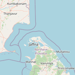
Geography guide, regional context, and park location map for Chundikkulam National Park

Chundikkulam National Park park geography, regions, and map view in Sri Lanka
Understand where Chundikkulam National Park sits in Sri Lanka through a broader geographic reading of the surrounding landscape, nearby location context, and its mapped position within the national park landscape.

How Chundikkulam National Park fits into Sri Lanka

Sri Lanka is a tropical island nation in South Asia with a recorded history spanning over 3,000 years. Formerly known as Ceylon, it became independent in 1948 and adopted its current constitutional name in 1972. The country features diverse geography ranging from coastal plains to mountainous highlands and maintains a population exceeding 22 million.

Wider geography shaping Chundikkulam National Park in Sri Lanka

Sri Lanka is an island nation in the Indian Ocean, positioned southwest of the Bay of Bengal. It is separated from India by the Gulf of Mannar and Palk Strait to the northwest. The island has a pear-like shape with diverse terrain including coastal plains, central highlands, and river valleys.

Map view of Chundikkulam National Park

Use this park location map to pinpoint Chundikkulam National Park in Sri Lanka, understand its exact geographic position, and read its mapped placement within the surrounding landscape more clearly.

Pigeon | © OpenStreetMap contributors

Location context for Chundikkulam National Park

Northern Province
Park atlas

Trace the regional park geography of Sri Lanka's Northern Province, comparing coastal wetlands and dry zone landscapes.

Explore Nearby Protected Areas and National Parks Surrounding Chundikkulam National Park
Continue your exploration from Chundikkulam National Park by discovering other protected areas and national parks across northern Sri Lanka. This atlas view allows you to compare diverse coastal wetlands, lagoon ecosystems, and dry zone scrub forests, providing richer geographic context for conservation landscapes.
National parkNorthern Province

Madhu Road National Park: Sri Lanka's Northern Province Dry Zone National Park

Explore protected landscapes and mapped geography.

Madhu Road National Park, situated in Sri Lanka's Northern Province, is a significant protected area defined by its dry zone ecosystems, including forests, grasslands, and wetlands. As one of the island's larger national parks, it offers critical habitat for diverse wildlife and represents an important component of northern Sri Lanka's conservation efforts. This page provides detailed atlas-style insights into the park's geography, mapped boundaries, and its ecological context within the region.

Area
631 km²
Established
2015
IUCN
II
Climate
Tropical
National parkNorthern Province

Delft National Park: Exploring Its Protected Landscape and Geographic Setting in Northern Province

Mapped boundaries and regional atlas context for this national park.

Delft National Park is a protected natural area situated in Sri Lanka's Northern Province, designated as a national park. This page offers an atlas-focused view of its protected boundaries, helping to contextualize its geographic setting and landscape character. Understanding Delft National Park involves exploring its specific location within the Northern Province and its role as a distinct entity in the study of mapped natural environments and regional geography.

Area
18.46 km²
Established
2015
IUCN
II
Relief
Lowland
National parkNorth Central Province

Horowpathana National Park: Protected Landscape within North Central Province's Dry Zone

Explore its mapped boundaries and vital wildlife habitat.

Horowpathana National Park is a designated national park in Sri Lanka's North Central Province, covering 2,570 hectares of dry zone forest. Established to protect critical habitats for endangered species like the Sri Lankan elephant and leopard, it plays a vital role in regional wildlife conservation and managing human-wildlife conflict. Its landscape is characterized by dry forest ecosystems situated near the Tawalamham Hammillewa reservoir system, presenting a unique environmental context within the broader mapped geography of the island.

Area
25.7 km²
Established
2011
IUCN
II
Climate
Tropical
National parkNorthern Province

Adam's Bridge Marine National Park: Protected Coastal Landscape and Geographic Significance

Mapped marine geography and protected island ecosystems.

Adam's Bridge Marine National Park is a protected national park in Sri Lanka's Northern Province, notable for encompassing the legendary Adam's Bridge. This marine protected area safeguards critical shallow-water habitats, including seagrass meadows and sand dunes, which are vital for migratory birds, dugongs, and sea turtles. The park's unique geographic identity as a chain of limestone shoals and islands offers a distinct landscape for atlas-based discovery and understanding of coastal conservation significance.

Area
190 km²
Established
2015
IUCN
II
Relief
Lowland
National parkTamil Nadu

Gulf of Mannar Marine National Park: Protected Island Archipelago and Marine Atlas

Explore India's vital marine national park and its coral reef ecosystems.

Gulf of Mannar Marine National Park is a designated national park located in Tamil Nadu, India, protecting a chain of 21 islands and their surrounding marine environments. This protected area is renowned for its extensive coral reefs, crucial seagrass meadows supporting dugongs, and diverse fish species, making it a key site for marine conservation and geographic exploration. The park's unique island landscape and intertidal zones offer a distinct perspective on coastal protected areas within the Indian Ocean, providing rich material for atlas-style discovery and understanding regional marine geography.

Area
560 km²
Established
1986
IUCN
II
Relief
Lowland
Watercolor illustration of a landscape with a lake, grassy areas, trees, and distant hills under a pale sky
National park

Wilpattu National Park: Sri Lanka's Largest National Park and Unique Willu Landscape

Explore mapped boundaries and high leopard density geography.

Wilpattu National Park, located in Sri Lanka's northwest coastal lowland dry zone, is the country's largest and one of its oldest national parks. Its landscape is defined by a unique system of nearly 106 natural sand-rimmed water basins, or willu, creating a distinctive wetland environment. The park is globally recognized for its substantial leopard population, representing one of the highest densities recorded in Sri Lanka. Discover the mapped terrain and protected area context of this ecologically vital landscape.

Area
1,316.67 km²
Established
1938
IUCN
II
Relief
Lowland
National parkNorth Central Province

Kaudulla National Park: Sri Lanka's Protected National Park Geography

Mapped landscape and regional context for Kaudulla National Park.

Kaudulla National Park stands as a protected national park offering valuable geographic insights for atlas explorers. This page details the park's location within the North Central Province, providing context on its mapped terrain and protected area status. Users can delve into the structured geographic data associated with Kaudulla National Park, enhancing their understanding of Sri Lanka's conservation landscapes.

Area
69 km²
Established
2002
IUCN
II
Visitors
10K annual
National parkSri Lanka

Somawathiya National Park: A Sri Lankan National Park Protected Landscape

Explore its mapped boundaries and regional geography.

Delve into the geographic identity of Somawathiya National Park, a designated national park within Sri Lanka. This entry provides atlas-level insights into its protected landscape, mapped terrain, and the specific natural area context it offers. Understand Somawathiya National Park's place in the Sri Lankan geography for structured discovery, focusing on its protected status and mapped features without travel logistics.

Area
376.455 km²
Established
1986
IUCN
II
Relief
Lowland

Common questions about visiting, size, designation, and location context for Chundikkulam National Park

Chundikkulam National Park FAQs for park facts, access, geography, and protected area context
Find quick answers about Chundikkulam National Park, including protected-area facts, park geography, trail and visitor context, and how the park fits into its surrounding country and regional landscape.
MoriAtlas Explorer

Continue Your Protected Areas Search Across the Global Atlas

Deepen your exploration by continuing the structured search for national parks and protected areas worldwide. Utilize the comprehensive filtering capabilities to compare different conservation landscapes and refine your understanding of global park geography. Discover more about the distribution and characteristics of protected natural areas.

Global natural geography