Mori Atlas logo
National parkDelft National Park

Trace the geographic context and protected landscape of this Sri Lankan national park.

Delft National Park: Mapped Protected Area and Regional Geography in Northern Province

Delft National Park stands as a significant protected area within Sri Lanka's Northern Province, offering a focal point for geographic exploration. As a national park, its mapped boundaries delineate a landscape rich in natural context, providing a valuable entity for understanding regional geography and protected lands. This page serves as a gateway to exploring the park's spatial identity and its place within the broader atlas of natural landscapes.

Island ParksWild HorsesNorthern Sri LankaCoastal EcosystemsSemi-Arid LandscapesWildlife Conservation

Delft National Park

National park

Park overview

Structured park overview, official facts, and landscape profile for Delft National Park

Delft National Park park facts, protected area profile, and essential visitor context
Review the core facts for Delft National Park, including designation, size, terrain, visitor scale, habitats, and operating context in one park-focused overview.

About Delft National Park

Delft National Park occupies the island of Neduntivu, commonly called Delft, which lies in the Palk Strait between the main island of Sri Lanka and the coasts of Tamil Nadu, India. The island's position in the far north of Sri Lanka places it in a markedly different climatic zone from the country's more famous southern and central protected areas, with a semi-arid character and distinct vegetation patterns. The establishment of the national park in 2015 represented a significant development in Sri Lanka's protected area network, particularly for the Northern Province, which had limited national park coverage due to decades of conflict and displacement. The park was created following detailed environmental assessment work carried out with support from the United Nations Development Programme and the United Nations Environment Programme, which recommended the designation of national parks across several areas in the Northern Province including Delft, Adam's Bridge, Chundikkulam, and Madhu Road. The park protects not only the unique wild pony population but also the broader island ecosystem and its coastal habitats, representing an important conservation resource for a region that has undergone substantial environmental neglect during periods of instability.

Quick facts and research context for Delft National Park

Delft National Park is situated on Delft Island (Neduntivu) in the Northern Province of Sri Lanka, approximately 35 kilometers southwest of Jaffna city. The park covers an area of 1,846 hectares (18 square kilometers) and was officially designated as a national park on 22 June 2015, making it one of Sri Lanka's newer protected areas. Administered by the Department of Wildlife Conservation under the Government of Sri Lanka, the park is classified as IUCN Category II. The island's distinctive semi-arid character, coastal location, and isolation have created unique ecological conditions that support the park's remarkable population of wild ponies.

Park context

Deeper park guide and search-rich context for Delft National Park

Delft National Park history, landscape, wildlife, and travel context
Explore Delft National Park through its history, landscape character, ecosystems, wildlife, conservation priorities, cultural context, and seasonal travel timing in a structured park guide built for atlas discovery and search intent.

Why Delft National Park stands out

Delft National Park is most renowned for its population of wild ponies, which are believed to be the only truly wild horse population in the world. These ponies have lived on Delft island for centuries, descendants of horses brought to the island during the Portuguese colonial era. The park's setting on a remote northern island also gives it distinction as one of Sri Lanka's most geographically unique protected areas, featuring coastal landscapes, scrub vegetation, and open terrain quite different from the wet zone forests typically associated with Sri Lankan national parks.

Delft National Park history and protected-area timeline

The formal establishment of Delft National Park followed years of environmental planning and assessment focused on post-conflict development in Sri Lanka's Northern Province. The Integrated Strategic Environmental Assessment of the Northern Province, produced with technical assistance from the United Nations Development Programme and United Nations Environment Programme and published in October 2014, provided the foundational recommendation for creating a national park on Delft island. The assessment identified approximately 1,846 hectares of the island as suitable for national park designation based on its ecological value and conservation potential. In May 2015, the Government of Sri Lanka announced that Delft, along with Adam's Bridge Marine National Park, Chundikkulam National Park, and Madhu Road National Park, would be designated as national parks. Delft officially became a national park on 22 June 2015, adding a unique protected area to Sri Lanka's park system that had no direct equivalent in terms of its wild equine population and island ecosystem character.

Delft National Park landscape and geographic character

Delft Island presents a landscape unlike most other Sri Lankan protected areas, characterized by its coastal island setting, relatively flat terrain, and semi-arid vegetation. The island sits in the Palk Strait with surrounding waters and coastal beaches marking its boundaries. The terrain consists largely of open country with scrubland and scattered grasslands, supporting the park's distinctive wildlife community. The island's isolation has shaped its ecology significantly, creating conditions that are quite different from mainland protected areas. The landscape also incorporates traditional settlement patterns and land uses that have influenced the island's character over centuries, with wild ponies roaming freely across both developed and natural areas of the island.

Delft National Park ecosystems, habitats, and plant life

The ecological character of Delft National Park is defined by its island setting and semi-arid conditions, which support a vegetation community quite different from the wet zone forests of Sri Lanka's famous southern parks. The park's scrubland and grassland habitats support a variety of species adapted to drier conditions and the island's particular environmental constraints. The most famous ecological residents are the wild ponies, which represent an introduced species that has successfully established a truly wild population over centuries of isolation. These ponies have adapted to the island's conditions and now exist as a unique feral population with no direct equivalent anywhere else in the world.

Delft National Park wildlife and species highlights

The wild ponies of Delft Island are the park's most notable wildlife feature and arguably its most significant conservation value. These ponies, believed to have been introduced by the Portuguese during their colonial presence in Sri Lanka, have survived and multiplied on the island for generations, becoming fully feral and establishing themselves as the world's only population of wild horses. Unlike managed wildlife populations in other parks, these ponies roam freely across the island with minimal intervention, making Delft a unique destination for observing truly wild equine behavior. The island also supports other wildlife including various bird species and smaller mammals adapted to the semi-arid island environment.

Delft National Park conservation status and protection priorities

Delft National Park represents an important conservation addition to Sri Lanka's protected area system, particularly because it protects a completely unique wildlife phenomenon in the form of the wild pony population. The establishment of the park provided formal legal protection to these ponies and their island habitat, ensuring that this remarkable population would be preserved for future generations. Beyond the ponies, the park's designation also protects the broader island ecosystem including coastal habitats and the semi-arid vegetation communities that characterize this northern region of Sri Lanka. The relatively recent establishment of the park in 2015 reflects Sri Lanka's ongoing expansion of its conservation network into previously underserved regions, with the Northern Province having historically limited national park coverage due to conflict-related constraints.

Delft National Park cultural meaning and human context

Delft Island has a long human history that has shaped its landscape and the presence of wild ponies. The pony population is directly tied to the colonial period when Portuguese traders or settlers brought horses to the island, likely in the 16th or 17th century. Over centuries, these domestic animals became feral and adapted to wild conditions, eventually establishing themselves as a unique population that has persisted through multiple eras of Sri Lankan history including Dutch and British colonial rule and independence. The ponies have become deeply embedded in the cultural identity of the island and are recognized as a defining characteristic of Delft, representing a living link to the island's colonial past. Local communities on the island have coexisted with the ponies for generations, and the animals remain an integral part of the island's character.

Top sights and standout views in Delft National Park

Delft National Park's defining highlight is its population of wild ponies, the only truly wild horse population in the world, descendants of colonial-era introductions by the Portuguese. The park's island location in Sri Lanka's Northern Province offers a distinctive alternative to the wet zone forests and mountainous terrain of more famous Sri Lankan protected areas. The semi-arid island ecosystem, coastal setting, and free-roaming wildlife create an experience quite unlike any other national park in South Asia.

Best time to visit Delft National Park

The best time to visit Delft National Park corresponds to the dry season in northern Sri Lanka, generally from May to September, when conditions are most stable and the island's landscape is accessible. However, the cooler months from November to March offer more comfortable temperatures for exploration and coincide with the peak travel season in Sri Lanka. Visitors should be aware that the island's remote location and limited infrastructure require careful planning, and the national park status does not yet mean the same level of visitor facilities found in more established parks.

Park location guide

Geography guide, regional context, and park location map for Delft National Park

Delft National Park park geography, regions, and map view in Sri Lanka
Understand where Delft National Park sits in Sri Lanka through a broader geographic reading of the surrounding landscape, nearby location context, and its mapped position within the national park landscape.

How Delft National Park fits into Sri Lanka

Sri Lanka is a tropical island nation in South Asia with a recorded history spanning over 3,000 years. Formerly known as Ceylon, it became independent in 1948 and adopted its current constitutional name in 1972. The country features diverse geography ranging from coastal plains to mountainous highlands and maintains a population exceeding 22 million.

Wider geography shaping Delft National Park in Sri Lanka

Sri Lanka is an island nation in the Indian Ocean, positioned southwest of the Bay of Bengal. It is separated from India by the Gulf of Mannar and Palk Strait to the northwest. The island has a pear-like shape with diverse terrain including coastal plains, central highlands, and river valleys.

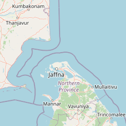
Map view of Delft National Park

Use this park location map to pinpoint Delft National Park in Sri Lanka, understand its exact geographic position, and read its mapped placement within the surrounding landscape more clearly.

Pigeon | © OpenStreetMap contributors

Location context for Delft National Park

Northern Province
Park atlas

Trace the regional spread of protected areas and compare diverse island ecosystems surrounding Delft National Park, across Sri Lanka's northern waters.

Compare Other Island Parks and Protected Areas Near Delft National Park in Sri Lanka
Browse additional national parks and protected areas within Sri Lanka's Northern Province and surrounding island geography, offering a deeper look into the region's diverse conservation landscapes near Delft National Park. This expanded view helps users trace the ecological connections and compare distinct protected-area types beyond Delft's unique semi-arid island ecosystem, enriching geographic understanding.
National parkTamil Nadu

Gulf of Mannar Marine National Park: Protected Island Archipelago and Marine Atlas

Explore India's vital marine national park and its coral reef ecosystems.

Gulf of Mannar Marine National Park is a designated national park located in Tamil Nadu, India, protecting a chain of 21 islands and their surrounding marine environments. This protected area is renowned for its extensive coral reefs, crucial seagrass meadows supporting dugongs, and diverse fish species, making it a key site for marine conservation and geographic exploration. The park's unique island landscape and intertidal zones offer a distinct perspective on coastal protected areas within the Indian Ocean, providing rich material for atlas-style discovery and understanding regional marine geography.

Area
560 km²
Established
1986
IUCN
II
Relief
Lowland
National parkNorthern Province

Adam's Bridge Marine National Park: Protected Coastal Landscape and Geographic Significance

Mapped marine geography and protected island ecosystems.

Adam's Bridge Marine National Park is a protected national park in Sri Lanka's Northern Province, notable for encompassing the legendary Adam's Bridge. This marine protected area safeguards critical shallow-water habitats, including seagrass meadows and sand dunes, which are vital for migratory birds, dugongs, and sea turtles. The park's unique geographic identity as a chain of limestone shoals and islands offers a distinct landscape for atlas-based discovery and understanding of coastal conservation significance.

Area
190 km²
Established
2015
IUCN
II
Relief
Lowland
National parkNorthern Province

Madhu Road National Park: Sri Lanka's Northern Province Dry Zone National Park

Explore protected landscapes and mapped geography.

Madhu Road National Park, situated in Sri Lanka's Northern Province, is a significant protected area defined by its dry zone ecosystems, including forests, grasslands, and wetlands. As one of the island's larger national parks, it offers critical habitat for diverse wildlife and represents an important component of northern Sri Lanka's conservation efforts. This page provides detailed atlas-style insights into the park's geography, mapped boundaries, and its ecological context within the region.

Area
631 km²
Established
2015
IUCN
II
Climate
Tropical
National parkNorthern Province

Chundikkulam National Park: Protected Landscape Identity and Geographic Atlas

Mapped park boundaries within Northern Province's regional geography.

Chundikkulam National Park stands as a protected landscape within Sri Lanka's Northern Province. This atlas entry provides structured details on its protected area status, allowing for a clear understanding of its geographic position and mapped boundaries. Explore the contextual geography and natural landscape features that define this significant national park, offering a factual basis for discovery.

Area
196 km²
Established
2015
IUCN
II
Relief
Lowland
Watercolor illustration of a landscape with a lake, grassy areas, trees, and distant hills under a pale sky
National park

Wilpattu National Park: Sri Lanka's Largest National Park and Unique Willu Landscape

Explore mapped boundaries and high leopard density geography.

Wilpattu National Park, located in Sri Lanka's northwest coastal lowland dry zone, is the country's largest and one of its oldest national parks. Its landscape is defined by a unique system of nearly 106 natural sand-rimmed water basins, or willu, creating a distinctive wetland environment. The park is globally recognized for its substantial leopard population, representing one of the highest densities recorded in Sri Lanka. Discover the mapped terrain and protected area context of this ecologically vital landscape.

Area
1,316.67 km²
Established
1938
IUCN
II
Relief
Lowland
National parkNorth Central Province

Horowpathana National Park: Protected Landscape within North Central Province's Dry Zone

Explore its mapped boundaries and vital wildlife habitat.

Horowpathana National Park is a designated national park in Sri Lanka's North Central Province, covering 2,570 hectares of dry zone forest. Established to protect critical habitats for endangered species like the Sri Lankan elephant and leopard, it plays a vital role in regional wildlife conservation and managing human-wildlife conflict. Its landscape is characterized by dry forest ecosystems situated near the Tawalamham Hammillewa reservoir system, presenting a unique environmental context within the broader mapped geography of the island.

Area
25.7 km²
Established
2011
IUCN
II
Climate
Tropical
National parkNorth Central Province

Kaudulla National Park: Sri Lanka's Protected National Park Geography

Mapped landscape and regional context for Kaudulla National Park.

Kaudulla National Park stands as a protected national park offering valuable geographic insights for atlas explorers. This page details the park's location within the North Central Province, providing context on its mapped terrain and protected area status. Users can delve into the structured geographic data associated with Kaudulla National Park, enhancing their understanding of Sri Lanka's conservation landscapes.

Area
69 km²
Established
2002
IUCN
II
Visitors
10K annual
National parkNorth Central Province

Minneriya National Park: A Protected National Park in North Central Province

Explore mapped boundaries and regional landscape context.

Minneriya National Park is a designated national park offering unique protected landscape exploration within Sri Lanka's North Central Province. This entry provides structured data crucial for understanding the park's geographic features, its defined boundaries, and its significance as a protected area. Dive into the atlas context that illuminates the natural terrain and regional setting of Minneriya National Park.

Area
88.894 km²
Established
1997
IUCN
II
Relief
Mixed relief

Common questions about visiting, size, designation, and location context for Delft National Park

Delft National Park FAQs for park facts, access, geography, and protected area context
Find quick answers about Delft National Park, including protected-area facts, park geography, trail and visitor context, and how the park fits into its surrounding country and regional landscape.
MoriAtlas Explorer

Continue Your Protected Areas Search Across the Global Atlas

Deepen your exploration by continuing the structured search for national parks and protected areas worldwide. Utilize the comprehensive filtering capabilities to compare different conservation landscapes and refine your understanding of global park geography. Discover more about the distribution and characteristics of protected natural areas.

Global natural geography