Hills
Skrabbelhøe
1,724 m

Detailed terrain analysis, administrative regional coverage, and landscape classifications
This geographic profile details the physical scope and environmental characteristics of Dovrefjell–Sunndalsfjella National Park. Examine the 1693 square kilometer boundary across Innlandet, Møre og Romsdal, and Trøndelag, including peaks like Snøhetta and diverse alpine habitats. The data provides a structured view of the mountain terrain and hydrological systems defining this protected landscape.
Norway's premier alpine wilderness protecting the last wild Fennoscandian reindeer
Dovrefjell–Sunndalsfjella National Park is Norway's largest mountain national park, established in 2002 through the expansion of the original Dovrefjell National Park from 1974. The park spans 1,693 square kilometres across three Norwegian counties—Innlandet, Trøndelag, and Møre og Romsdal—encompassing the dramatic Dovrefjell mountain range along with the Sunndalsfjella peaks. This protected area represents one of Scandinavia's most significant alpine wilderness regions, preserving a largely untouched mountain ecosystem with remarkable ecological and geological value. The landscape is characterized by rugged peaks, deep valleys, glacial formations, and the famous Snøhetta, the park's highest summit at 2,286 metres.
Mapping the park boundaries across three distinct regions in Norway
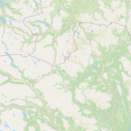
Map boundaries and spatial dimensions spanning 1693 square kilometers
Mountain relief profile and recorded natural formations
Hills
1,724 m
Streams
Ridges
Peaks
2,286 m
Streams
Streams
Alpine habitats, boreal zones, and mountain relief profiles
Mountains · Valleys · Rivers · Waterfalls · Glacier
Alpine meadow · Boreal forest · Montane forest · Riverine habitat · Wetland
Trace the Alpine Protected Landscapes of Innlandet County and Adjacent Regions
South

A vital bridge for mountain migration in Innlandet, Norway.
Fokstugu landskapsvernområde protects a unique mix of alpine terrain, geological formations, and cultural mountain heritage across the Dovrefjell plateau. Serving as a connective corridor between major national parks, this protected area maintains essential migratory paths for wild reindeer and preserves traditional Norwegian upland farming features.
Southeast
Norway's protected mountain plateau landscape and wildlife corridor.
Dovre National Park is a significant protected area in Innlandet, Norway, characterized by its expansive alpine plateau terrain and role as a vital ecological corridor for wild reindeer. This national park offers users an atlas-level view of its mapped natural boundaries, focusing on the unique subarctic mountain landscape and its conservation importance. Understand Dovre National Park's geographic identity and its contribution to a contiguous network of protected lands.
South
Mapped glacial terrain, iconic peaks, and wild reindeer sanctuary.
As Norway's first national park, Rondane offers a profound exploration of a protected alpine environment. Situated in Innlandet county, its 963 square kilometers showcase a landscape sculpted by glaciers, featuring a striking array of ten peaks exceeding 2,000 meters. This page details Rondane National Park's distinct mapped boundaries, dramatic mountain geography, and its ecological significance as a refuge for wild reindeer, making it a cornerstone of Scandinavian natural heritage.
East
Explore unique terrain and vital wild reindeer habitat in Central Norway.
MoriAtlas provides structured geographic context for Forollhogna National Park, Norway's nineteenth national park. This area is best known for its distinctively gentle, rolling alpine terrain, a contrast to other Norwegian mountain ranges, and as a critical habitat for wild reindeer. Discover the park's unique landscape character, its role as a protected area, and the ongoing cultural traditions tied to its mountain pastures, all visualized within a comprehensive atlas framework.
Southwest
Map of protected boundaries and diverse mountain terrain.
Reinheimen National Park is a cornerstone of Norway's protected areas, encompassing a substantial portion of Western Norway's alpine wilderness. This national park protects a dynamic landscape characterized by dramatic western peaks and gentler eastern plateaus, providing critical habitat for wild reindeer and other wildlife. Its extensive mapped boundaries and varied natural terrain offer a rich subject for geographic discovery and atlas exploration, highlighting the ecological significance of well-preserved mountain ecosystems within Innlandet.
Southwest
Explore mapped glacial terrain and alpine geography.
Jotunheimen National Park stands as a monument to Norway's alpine grandeur, protecting over 1,151 square kilometers of spectacular mountainous terrain. This protected area is defined by its dramatic glacial features, including sharp peaks exceeding 1,900 meters, U-shaped valleys, and pristine alpine lakes, making it a significant focus for geographic exploration and mapped landscape study. Delve into the core of Norway's mountain heartland, understanding the mapped boundaries and regional geological context that shape this iconic protected landscape.
Southwest
Mapped terrain and protected area discovery in Vestland, Norway.
Jostedalsbreen National Park represents a unique geographic entity, safeguarding the largest glacier on the European mainland. This national park, situated in Norway's Vestland region, offers profound insights into glacial landscapes and mountain geography. Users can explore the vast ice mass that dominates the terrain, observe the U-shaped valleys carved by its movement, and understand the geological processes shaping this dynamic environment. The park's protected status highlights its importance for understanding glacial science and preserving a critical component of Norway's natural heritage.
South
Discover mapped boundaries and regional geographic context.
Langsua National Park, a designation expanded in 2011, is a prominent protected area in Norway's Innlandet county. This national park encompasses 537.1 square kilometers of diverse mountainous terrain, characterized by extensive mountain forests and inland wilderness habitats. Its creation consolidates fragmented nature reserves into a significant contiguous protected landscape, offering valuable insight into Norway's conservation strategies and the geographic context of its eastern mountain regions.
Deepen your exploration of Dovrefjell–Sunndalsfjella National Park by examining its precise geographic context and protected landscape features within the MoriAtlas. Understanding the mapped boundaries and terrain of this significant national park provides valuable insights into Norway's conservation efforts and Scandinavian alpine geography. Continue your atlas discovery to appreciate the full scope of this protected wilderness.