
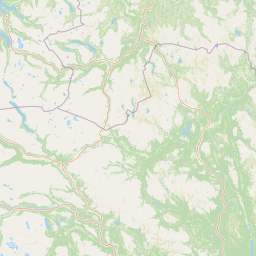
Rivers
Park geography
Structured data on regional boundaries, mountain terrain, and natural habitat classification.
Geographic Profile and Landscape Mapping for Forollhogna National Park in Central Norway
The geographic profile of Forollhogna National Park encompasses 1062 square kilometers across six municipalities in the Trøndelag and Innlandet regions of Norway. This structured record details the mountain terrain, alpine meadow habitats, and specific peaks such as Forollhogna and Storskarven situated within the recorded park boundaries.
Related tags
Alpine EnvironmentWild ReindeerNorwegian MountainsCultural LandscapeProtected Area
Norway's gentle mountains and wild reindeer sanctuary
Forollhogna National Park
Forollhogna National Park is Norway's nineteenth national park, established in December 2001 to protect a distinctive alpine landscape in the central part of the country. The park spans approximately 1,062 square kilometers across the counties of Trøndelag and Innlandet, encompassing portions of six municipalities: Tynset, Tolga, and Os in Innlandet, and Holtålen, Midtre Gauldal, and Rennebu in Trøndelag. The park is centered around the mountain Forollhogna, which serves as a natural border between the two historic regions. What makes this park particularly distinctive is its characteristic landscape of gentle, rolling alpine terrain—a contrast to Norway's more dramatic mountain ranges. The area supports extensive plant communities and represents one of Norway's most important ranges for wild reindeer, a species of significant conservation concern in Scandinavia.
- Location
- Norway
- Park type
- National park
- Established
- 2001
- Area
- 1,062 km²
Location overview
Administrative boundaries within Trøndelag and Innlandet regions
Geographic Positioning of Forollhogna National Park in Norway
Forollhogna National Park is situated in Norway, spanning the regional territories of Trøndelag and Innlandet. Map records define the interior protected landscape as a non-coastal, non-marine mainland wilderness area.
- Countries
- Norway
- Regions
- Innlandet, Trøndelag
- Primary location
- Norway
- Geographic setting
- Inland
Boundary and coordinates
Spatial extent and coordinate limits covering 1062 square kilometers
Forollhogna National Park Boundary Map and Spatial Limits
The mapped outline displays the spatial context and geographic shape of Forollhogna National Park. Accompanying data details the total area of 1062 square kilometers along with calculated coordinates and regional center points.
- Boundary area
- 1,060.8 km²
- Boundary perimeter
- 324.1 km
- Northernmost point
- 62.9066° N
- Southernmost point
- 62.4662° N
- Easternmost point
- 11.1527° E
- Westernmost point
- 10.137° E
- Geographic centre
- 62.6898° N, 10.709° E
- North–south span
- 49.1 km
- East–west span
- 52 km
Terrain and natural features
Explore mountain classifications and internal natural features
Forollhogna National Park Terrain and Named Natural Features
Mountain terrain classifications govern the regional park landscape alongside recorded peaks, rivers, and streams. Linked feature cards supply names, types, and spatial relationships within the boundary.
Selected named natural features
Peaks
Hestfjellet
1,224 m
Peaks
Tangen
1,128 m
Peaks
Korsfonnfjellet
1,061 m
Peaks
Sauhogna
1,160 m
Streams
Halstjønnbekken
Environmental setting
Alpine meadows, boreal forests, and subpolar climate classifications across mountain terrain
Forollhogna National Park Environmental Setting and Physical Geography Classifications
Recorded landscape features, habitat types, and subpolar climate zones provide interpretive categories for the physical setting of Forollhogna National Park. Structured classifications connect stored environmental data to relevant atlas destinations across protected areas.
- Relief
- Mountain
- Climate
- Subpolar
- Water
- Minor water
Landscape features
Mountains · Valleys · Grassland · Wetland
Habitat types
Alpine meadow · Grassland · Wetland · Boreal forest
Park atlas
Trace the geographic spread of protected landscapes, comparing alpine terrain and wild reindeer habitats near Forollhogna.
Discover Nearby National Parks and Protected Areas Surrounding Forollhogna National Park
After exploring Forollhogna National Park's distinctive gentle alpine terrain, browse a curated list of nearby national parks and protected areas across Central Norway. Compare these mapped conservation landscapes to understand regional ecological connections and diverse protected geographies.
National parkInnlandet
35 km away#1 closest
West

Dovrefjell, Sunndalsfjella National Park: Mapping Norway's Largest Alpine Protected Landscape
Explore its protected boundaries, mountain terrain, and unique ecological significance.
Dovrefjell, Sunndalsfjella National Park is a cornerstone of Norwegian protected areas, offering an expansive alpine wilderness with dramatic mountain scenery. This page details the park's geographic context, mapped landscape features, and its importance as a refuge for unique wildlife like wild reindeer and muskox. Users can investigate the park's protected boundaries and understand its role within the regional geography of Innlandet, contributing to a structured atlas of Scandinavia's natural heritage.
- Area
- 1,693 km²
- Established
- 2002
- IUCN
- II
- Relief
- Mountain
National parkTrøndelag
About 41 km away#2 closest
Northeast
Skarvan and Roltdalen National Park: Protected Wilderness and Trøndelag Landscape Atlas
Explore extensive peatlands, alpine terrain, and regional geography.
The Skarvan and Roltdalen National Park detail page offers an atlas-driven exploration of this protected landscape in Norway's Trøndelag region. Discover its vast peatland systems, the intact Roltdalen valley, and its alpine environments. This page provides detailed geographic context and mapped features, highlighting the park's significance within the regional natural heritage.
- Area
- 441.5 km²
- Established
- 2004
- IUCN
- II
- Relief
- Mountain
National parkInnlandet
58 km away#3 closest
Southwest
Rondane National Park: Norway's Premier Alpine Protected Landscape and Historic National Park
Mapped glacial terrain, iconic peaks, and wild reindeer sanctuary.
As Norway's first national park, Rondane offers a profound exploration of a protected alpine environment. Situated in Innlandet county, its 963 square kilometers showcase a landscape sculpted by glaciers, featuring a striking array of ten peaks exceeding 2,000 meters. This page details Rondane National Park's distinct mapped boundaries, dramatic mountain geography, and its ecological significance as a refuge for wild reindeer, making it a cornerstone of Scandinavian natural heritage.
- Area
- 963 km²
- Established
- 1962
- IUCN
- II
- Relief
- Mountain
National parkInnlandet
About 69 km away#4 closest
Southeast
Femundsmarka National Park: Exploring Norway's Distinctive Wetland and Boreal Protected Landscape
Mapped boundaries and regional geography in Innlandet.
Femundsmarka National Park in Innlandet, Norway, offers a profound look into a preserved wetland wilderness characterized by vast marshlands, numerous lakes, and scattered boreal forests. As a designated national park, its ecological significance is tied to the surrounding water systems and the unique landscape stretching towards the Swedish border. This entry provides detailed geographic context, mapping information, and an understanding of its protected area status, inviting exploration of its remote boreal terrain and notable wildlife habitats.
- Area
- 573 km²
- Established
- 1971
- IUCN
- II
- Relief
- Mixed relief
National parkInnlandet
About 71 km away#5 closest
Southwest
Dovre National Park: Mapped Alpine Terrain & Protected Reindeer Habitat in Innlandet
Norway's protected mountain plateau landscape and wildlife corridor.
Dovre National Park is a significant protected area in Innlandet, Norway, characterized by its expansive alpine plateau terrain and role as a vital ecological corridor for wild reindeer. This national park offers users an atlas-level view of its mapped natural boundaries, focusing on the unique subarctic mountain landscape and its conservation importance. Understand Dovre National Park's geographic identity and its contribution to a contiguous network of protected lands.
- Area
- 289 km²
- Established
- 2003
- IUCN
- II
- Relief
- Mountain
Marine protected areaNorway
About 76 km away#6 closest
North
Tauterryggen Marine Protected Area: Submerged Glacial Ridge and Coral Reef Map in Norway
Tracing the geological boundaries and marine biodiversity of the Trondheimsfjord.
Tauterryggen represents a crucial nexus of marine conservation and glacial history. This protected submerged ridge serves as the home to unusually shallow cold-water coral colonies, offering an essential window into the complex biological and geological dynamics of the Norwegian fjord system. The area provides a pristine example of protected underwater terrain where trawling and drilling are prohibited to ensure habitat integrity.
- Established
- 2013
- Relief
- Lowland
- Climate
- Temperate
- Access
- Access unknown
Protected landscapeInnlandet
About 79 km away#7 closest
Southwest
Fokstugu landskapsvernområde: Alpine Protected Landscape and Regional Ecological Corridor
A vital bridge for mountain migration in Innlandet, Norway.
Fokstugu landskapsvernområde protects a unique mix of alpine terrain, geological formations, and cultural mountain heritage across the Dovrefjell plateau. Serving as a connective corridor between major national parks, this protected area maintains essential migratory paths for wild reindeer and preserves traditional Norwegian upland farming features.
- Area
- 72.3 km²
- Established
- 2002
- Relief
- Mountain
- Climate
- Alpine
National parkInnlandet
About 84 km away#8 closest
Southeast
Gutulia National Park: Protected Southernmost Mountain Birch Forest Landscape Atlas
Explore Norway's unique subarctic forest geography and park boundaries.
Gutulia National Park stands as a key protected area within Norway's Innlandet region, distinguished by its role in preserving the country's southernmost mountain birch forest ecosystem. Covering approximately 23 square kilometers, this national park provides critical insights into subarctic forest ecology at the southern extent of its natural range. MoriAtlas enables detailed exploration of its mapped terrain and geographic context, offering a valuable resource for understanding this significant protected landscape.
- Area
- 23 km²
- Established
- 1968
- IUCN
- II
- Scope
- Terrestrial
MoriAtlas Explorer
Continue exploring Forollhogna National Park's geographic and landscape context
Deepen your understanding of Forollhogna National Park by exploring its specific mapped boundaries and the surrounding regional geography. Discover how this protected landscape fits into the broader atlas of Norwegian natural areas and the vital role it plays in conserving unique alpine environments and their wildlife. This structured approach allows for a factual comparison and contextualization of protected lands.
Browse next
Global natural geography
Explore related park routes
Explore MoriAtlas Global ParksBrowse All MoriAtlas ParksGlobal Park Map DiscoveryMoriAtlas: Browse All CountriesBrowse All MoriAtlas ContinentsNational Park Environment AtlasGrand Canyon National Park AtlasYellowstone National Park AtlasYosemite National Park Atlas and GeographySerengeti National Park AtlasGalápagos National Park Protected LandscapeBanff National Park Geography and AtlasKruger National Park Atlas EntryUluṟu-Kata Tjuṯa National Park AtlasExplore Uluru-Kata Tjuta National Park GeographyPlitvice Lakes National Park AtlasFiordland National Park Protected LandscapeGreat Smoky Mountains National Park AtlasAfghanistan National Parks and Protected AreasAlbania National Parks and Protected AreasAlgeria National Parks and Protected AreasAmerican Samoa National Parks and Protected AreasAndorra National Parks and Protected AreasAngola National Parks and Protected AreasAntarctica National Parks and Protected AreasAntigua and Barbuda Park List