Mori Atlas logo
National parkGovind Pashu Vihar National Park

Understand the mapped boundaries and regional setting of this Indian national park.

Govind Pashu Vihar National Park: Protected Landscape and Geographic Context in Uttarkashi District

(Govind Pashu Vihar National Park and Wildlife Sanctuary)

Govind Pashu Vihar National Park stands as a protected natural area within India's Uttarkashi District, offering a distinct geographic identity. This page details its protected landscape, providing critical context for understanding its placement within regional geography and its mapped boundaries. Explore the park's significance as a national park and its contribution to the broader atlas of protected lands.

Himalayan national parkSnow leopard habitatAlpine ecosystemsProtected areaWildlife sanctuaryMountain landscapes

Govind Pashu Vihar National Park

National park

Park overview

Structured park overview, official facts, and landscape profile for Govind Pashu Vihar National Park

Govind Pashu Vihar National Park park facts, protected area profile, and essential visitor context

Review the core facts for Govind Pashu Vihar National Park, including designation, size, terrain, visitor scale, habitats, and operating context in one park-focused overview.

About Govind Pashu Vihar National Park

Govind Pashu Vihar National Park and Wildlife Sanctuary occupies a significant position in India's network of protected areas, located in the Supin Range near Uttarkashi town in Uttarakhand state. The park's establishment in 1955 marked an important step in the conservation of Himalayan ecosystems, and its later designation as a national park elevated its protection status. The park's name honors Govind Ballabh Pant, whose contributions to Indian independence and governance shaped modern India. The park spans approximately 958 square kilometers of mountainous terrain in the Garhwal Himalayas, an area of immense ecological and cultural significance. The Snow Leopard Project, initiated by the Government of India, is managed from this sanctuary, reflecting the park's critical role in protecting one of the world's most endangered large cats. The park supports a remarkable diversity of ecosystems due to its dramatic altitudinal range, which creates distinct ecological zones from subtropical forests at lower elevations to permanent snow and rock at the highest peaks. This vertical stratification supports a rich array of flora and fauna adapted to different climatic zones, making the park a living laboratory for understanding Himalayan ecology.

Quick facts and research context for Govind Pashu Vihar National Park

Govind Pashu Vihar National Park covers 958 square kilometers in Uttarkashi district, Uttarakhand, India. The park lies in the higher Garhwal Himalayan region with altitudes ranging from 1,400 to 6,323 meters. Established on March 1, 1955, as a wildlife sanctuary before becoming a national park, it is named after Govind Ballabh Pant. The park is managed under India's Snow Leopard Project and is one of the few remaining strongholds for this endangered predator in the Himalayas. Notable features include the Har Ki Doon valley, a popular trekking destination, and the Ruinsiyara high altitude lake.

Protection and recognition

Terrestrial protection levels, official designation records, and boundary framework details

Govind Pashu Vihar National Park Protection Status and Designated Area Profile

Researchers can evaluate the official terrestrial boundary records and conservation frameworks that define Govind Pashu Vihar National Park. Comprehensive datasets aggregate documented protection levels, official management scopes, and global registry details to support geographic analysis of mountain environments.

Protection details

Protection scope
Terrestrial
Transboundary protection
No
Park context

Deeper park guide and search-rich context for Govind Pashu Vihar National Park

Govind Pashu Vihar National Park history, landscape, wildlife, and travel context

Explore Govind Pashu Vihar National Park through its history, landscape character, ecosystems, wildlife, conservation priorities, cultural context, and seasonal travel timing in a structured park guide built for atlas discovery and search intent.

Why Govind Pashu Vihar National Park stands out

Govind Pashu Vihar is best known as a critical habitat for the snow leopard, one of the rarest and most elusive big cats in the world. The park is also renowned as one of the last strongholds of the bearded vulture in the Himalayas, a species that plays a vital ecological role as a scavenger in high-altitude environments. The Har Ki Doon valley within the park is a famous trekking destination, while the diverse altitudinal range supports a remarkable transition from temperate broadleaf forests through subalpine conifer forests to alpine meadows and rock, making it one of the most ecologically diverse protected areas in the Indian Himalayas.

Govind Pashu Vihar National Park history and protected-area timeline

The area that now comprises Govind Pashu Vihar National Park was initially established as a wildlife sanctuary on March 1, 1955, reflecting post-independence India's growing commitment to wildlife conservation. The park was later upgraded to national park status, providing stronger legal protection for its unique ecosystems. The naming of the park after Govind Ballabh Pant connects the protected area to the legacy of one of India's most influential political figures, who played a crucial role in India's independence movement and later as Home Minister in the post-independence government. Prior to India's independence, the British managed the area primarily for timber extraction, building roads, and maintaining forest rest houses for their administrative convenience. After independence in 1947, the state forest department assumed management responsibilities, and regulations increased while commercial timber extraction decreased. Development continued through subsequent decades, with roads extended into the park, schools and administrative buildings constructed, and tourism gradually increased. By 1988, the road had reached Sankri inside the park, and visitor numbers grew from 300 that year to over one thousand by 1990, predominantly domestic tourists. The establishment of the Snow Leopard Project at this sanctuary underscored its importance as a critical habitat for India's endangered alpine wildlife.

Govind Pashu Vihar National Park landscape and geographic character

The landscape of Govind Pashu Vihar National Park is characterized by dramatic topographical variation shaped by the dynamics of the Garhwal Himalayas. The park spans elevations from 1,400 meters to 6,323 meters above sea level, creating a spectacular vertical profile of distinct terrain types. The Har Ki Doon valley, a prominent feature within the park, is renowned for its scenic beauty and serves as a popular destination for trekking enthusiasts. This valley, surrounded by mountain peaks and accessible via forest rest houses at Naitwar, Taluka, and Osla, offers visitors an immersive experience of Himalayan wilderness. The Ruinsiyara high altitude lake provides another significant landscape feature, attracting tourists to its pristine alpine setting. The terrain transitions from forested slopes at lower elevations through rocky alpine meadows to permanent snow and glaciated peaks at the highest levels. The park encompasses a network of valleys, ridges, and sheer mountain faces that define the characteristic Himalayan landscape of this region.

Govind Pashu Vihar National Park ecosystems, habitats, and plant life

The ecological diversity of Govind Pashu Vihar National Park reflects its remarkable altitudinal range and position in the western Himalayas. At lower elevations below approximately 1,400 meters, the park contains western Himalayan broadleaf forests characterized by species including chir pine, deodar cedar, oak, and various deciduous trees. As elevation increases, the vegetation transitions to western Himalayan subalpine conifer forests dominated by blue pine, silver fir, spruce, and yew. Above approximately 2,600 meters, the forests give way to western Himalayan alpine shrub and meadows, where species such as oak, maple, walnut, horse chestnut, hazel, and rhododendron create a distinct alpine character. This vertical zonation of vegetation creates distinct ecological corridors that support diverse wildlife communities adapted to different altitude zones. The park's position in the Garhwal Himalayas places it at a critical biogeographic intersection, making it important for maintaining ecological connectivity across the Himalayan region.

Govind Pashu Vihar National Park wildlife and species highlights

Govind Pashu Vihar National Park supports a rich mammalian and avian fauna, with approximately fifteen species of large mammals and around one hundred fifty species of birds recorded within its boundaries. The park is most renowned as a habitat for the snow leopard, an endangered predator that faces threats from declining wild prey populations, poaching for its pelt and body parts, and conflict with livestock farmers. The Snow Leopard Project, inaugurated by the Indian Government from this sanctuary, aims to provide special conservation measures for this elusive big cat. Other notable mammals include the Asian black bear, brown bear, common leopard, musk deer, bharal, Himalayan tahr, and serow. The smaller mammal community includes Indian crested porcupine, European otter, goral, civet, hedgehog, Himalayan field rat, Hodgson's giant flying squirrel, wild boar, masked palm civet, and Sikkim mountain vole. The avian fauna includes several endangered species such as the golden eagle, steppe eagle, black eagle, bearded vulture, Himalayan snowcock, Himalayan monal pheasant, cheer pheasant, and western tragopan, alongside numerous smaller bird species including owls, pigeons, minivets, thrushes, warblers, bulbuls, parakeets, cuckoos, and finches.

Govind Pashu Vihar National Park conservation status and protection priorities

Govind Pashu Vihar National Park represents one of the most significant conservation areas in the Indian Himalayas, serving as a critical stronghold for several endangered species. The park's designation as a protected area under IUCN Category II reflects its importance in preserving natural ecosystems and biodiversity. The Snow Leopard Project, managed from this sanctuary, represents India's flagship conservation initiative for protecting this endangered predator, addressing the multiple threats facing snow leopards including prey decline, poaching, and human-wildlife conflict. The park also serves as a crucial habitat for the bearded vulture, a species that plays an important ecological role as a high-altitude scavenger. The management of the park involves balancing conservation objectives with the growing interest in eco-tourism, as visitors from across India and abroad are drawn to its natural beauty and wildlife. The park's diverse ecosystems, ranging from broadleaf forests to alpine meadows, require integrated management approaches that address the complex interactions between wildlife populations, habitat integrity, and human activities.

Govind Pashu Vihar National Park cultural meaning and human context

The region surrounding Govind Pashu Vihar National Park has been inhabited by local communities whose relationship with the landscape spans generations. Before independence, the British managed the area primarily for resource extraction, establishing forest rest houses and building roads for administrative and commercial purposes. Following independence, the management paradigm shifted toward conservation and sustainable use, though development continued with the construction of infrastructure including roads to Naitwar, schools, administrative buildings, and a small hospital. Immigration from Nepal and other regions increased following these developments, with new arrivals establishing shops, restaurants, and other services catering to visitors. The forest rest houses at locations such as Har-ki-dun, Naitwar, Taluka, and Osla have long served as staging points for visitors exploring this Himalayan landscape, creating a cultural interface between the protected area and surrounding communities. The park's historical management reflects the broader evolution of wildlife conservation in India from colonial extractive practices to post-independence protection frameworks.

Top sights and standout views in Govind Pashu Vihar National Park

The Har Ki Doon valley stands as the park's most famous trekking destination, offering access to pristine Himalayan scenery and the famous forest rest house set amid wildflower-filled meadows. The Ruinsiyara high altitude lake provides another major attraction for visitors seeking alpine lake experiences. The park's significance as one of the last Himalayan strongholds for the snow leopard makes it a destination of global conservation importance. The bearded vulture population represents a remarkable ecological asset, as this species serves as a vital scavenger in high-altitude ecosystems. The dramatic altitudinal range from 1,400 to 6,323 meters creates unparalleled ecological diversity within a single protected area, supporting distinct forest types and wildlife communities at different elevations. The forest rest houses at Naitwar, Taluka, and Osla provide visitor access to the park's interior regions.

Best time to visit Govind Pashu Vihar National Park

The optimal time to visit Govind Pashu Vihar National Park depends on the experience sought, with each season offering distinct advantages. The summer months from May to June provide pleasant weather at lower elevations and clear mountain views, making this period ideal for trekking in the Har Ki Doon valley and wildlife observation. The monsoon season from July to September brings heavy rainfall to the region, which can cause Landslides and flooding, making this period less suitable for visits. Autumn from September to November offers stable weather conditions and excellent visibility, with the post-monsoon clarity providing stunning mountain vistas. Winter from December to February brings heavy snowfall to higher elevations, creating spectacular winter landscapes but making many trails inaccessible and wildlife more difficult to observe. The park's high-altitude location means temperatures can drop significantly, especially above 3,000 meters, so visitors should prepare for cold conditions regardless of the season chosen.
Monthly climate preview

Trace long-term representative monthly temperature and precipitation patterns across the protected landscape

Govind Pashu Vihar National Park Climate Normals, Annual Temperature, and Precipitation Rhythm

Govind Pashu Vihar National Park exhibits measured long-term temperature variations alongside distinct precipitation rhythms across its representative coordinate. Reviewing the complete twelve-month climatology profile provides deeper analytical insight into annual meteorological trends.
Annual mean11 °C
2 °C18 °C
Jan
Feb
Mar
Apr12°
May16°
Jun18°
Jul18°
Aug17°
Sep15°
Oct10°
Nov
Dec
Warmest month
June

18.4 °C

Coolest month
January

1.7 °C

Wettest month
August

8.3 mm/day

Driest month
November

0.2 mm/day

Park location guide

Geography guide, regional context, and park location map for Govind Pashu Vihar National Park

Govind Pashu Vihar National Park park geography, regions, and map view in India

Understand where Govind Pashu Vihar National Park sits in India through a broader geographic reading of the surrounding landscape, nearby location context, and its mapped position within the national park landscape.

How Govind Pashu Vihar National Park fits into India

India is a South Asian country bordered by the Indian Ocean, Arabian Sea, and Bay of Bengal. It shares land borders with Pakistan, China, Nepal, Bhutan, Bangladesh, and Myanmar. The country has a population of over 1.4 billion people and operates as a federal parliamentary republic with its capital in New Delhi.

Wider geography shaping Govind Pashu Vihar National Park in India

India occupies the Indian subcontinent in South Asia, bordered by the Arabian Sea to the southwest, the Bay of Bengal to the southeast, and the Indian Ocean to the south. It shares land borders with Pakistan to the west, China, Nepal, and Bhutan to the north, and Bangladesh and Myanmar to the east. The territory also includes the Andaman and Nicobar Islands in the Indian Ocean.

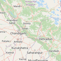
Map view of Govind Pashu Vihar National Park

Use this park location map to pinpoint Govind Pashu Vihar National Park in India, understand its exact geographic position, and read its mapped placement within the surrounding landscape more clearly.

Pigeon | © OpenStreetMap contributors

Location context for Govind Pashu Vihar National Park

UttarakhandUttarkashi District
Park atlas

Explore adjacent protected landscapes and compare mountain parks across the wider Himalayan region.

Discover Other National Parks and Protected Areas Near Govind Pashu Vihar National Park

Explore additional national parks and protected areas geographically close to Govind Pashu Vihar National Park in the Garhwal Himalayas, including other critical conservation landscapes and high-altitude ecosystems. Compare distinct park geographies, trace the spread of protected zones, and understand regional conservation efforts across similar mountain environments and diverse habitats.
National parkHimachal Pradesh
About 85 km away#1 closest

Northwest

Great Himalayan National Park: Protected Landscape and Mapped Geography

Explore this national park's dramatic elevation and rich biodiversity.

Great Himalayan National Park is a vital protected area within India's Himachal Pradesh, celebrated for its exceptional biodiversity and dramatic mountain geography. This national park encompasses a remarkable range of elevations, creating distinct ecological zones from lower forest elevations to high alpine meadows and glacial zones. Its significance as a mapped protected landscape makes it essential for understanding regional natural heritage and conservation efforts within the Himalayas.

Area
1,171 km²
Established
1984
IUCN
II
Relief
Mountain
Wildlife reserveUttarakhand
About 92 km away#2 closest

Southwest

Asan Conservation Reserve: Protected Wetland and Reservoir Geography in Uttarakhand

Mapping the landscape of North India's premier Ramsar site

Located in the Doon Valley of Uttarakhand, Asan Conservation Reserve creates a distinct natural refuge within a working hydrological system. This wildlife reserve features shallow reservoir basins and marshy shorelines, providing a key corridor for migratory bird species and serving as an anchor for regional conservation efforts.

Area
4 km²
Established
1967
Water
Water-dominated
Season
Year-round
Wildlife reserveHimachal Pradesh
About 96 km away#3 closest

Southwest

Renuka Sanctuary: Protected Wildlife Reserve and Ramsar Wetland Site in Himachal Pradesh

Ecological catchment and forest basin in the low Himalayan hills

Renuka Sanctuary is a dedicated wildlife reserve in Himachal Pradesh defined by the expansive Renuka Lake and its surrounding dry deciduous forest cover. This Ramsar wetland area protects the critical catchment zone of the state's largest natural lake, offering a unique intersection of conservation land and culturally significant natural terrain.

Area
4.028 km²
Water
Major water bodies
National parkHimachal Pradesh
About 107 km away#4 closest

North

Pin Valley National Park: Remote Himalayan Cold Desert National Park in Himachal Pradesh

Explore its dramatic terrain and unique protected landscape in Spiti Valley.

Pin Valley National Park is a significant protected area covering roughly 675 square kilometers of the cold desert region in Himachal Pradesh, India. Established as a national park, it showcases a remote and rugged Himalayan landscape, characterized by its stark beauty, sparse vegetation, and extreme temperatures typical of high-altitude deserts. The park's geography spans dramatic mountain terrain, steep cliffs, and deep valleys, forming a vital habitat for endangered species and contributing to the unique ecological profile of the Cold Desert Biosphere Reserve.

Area
675 km²
Established
1987
IUCN
II
Relief
Mountain
National parkIndia
About 107 km away#5 closest

Southwest

Simbalbara National Park: National Park in India's Himalayan Foothills

Explore its dense sal forests and unique terrain.

Simbalbara National Park is a protected area recognized for its extensive sal forests and its role as a vital habitat for tigers and other large mammals in the Himalayan foothills of India. The park's landscape is defined by the Kiyarda Dun valley, featuring a mix of dense forest-covered slopes, open grassy glades, and a perennial stream. This protected area offers a representative sample of the sal-dominated forest ecosystems at lower Himalayan elevations, providing a distinct geographic and ecological context for exploration.

Area
27.88 km²
Established
2010
IUCN
II
Relief
Upland
National parkHaryana
About 109 km away#6 closest

Southwest

Kalesar National Park: Exploring Haryana's Unique Sal Forest Protected Landscape

Discover mapped terrain and regional geography within the Shivalik foothills.

Kalesar National Park, located in the Shivalik foothills of Haryana, is a crucial protected area renowned for its natural sal forest, a rare ecological feature in the state. Spanning approximately 53 square kilometers, the park's diverse terrain offers insights into regional geography and conservation, serving as a vital habitat for leopards and a corridor for wild elephants. Its mapped boundaries encompass a unique landscape that contrasts sharply with surrounding agricultural lands, making it a significant point of study for protected-area enthusiasts.

Area
53 km²
Established
2003
IUCN
IV
Relief
Highland
National parkUttarakhand
About 116 km away#7 closest

South

Rajaji National Park: Uttarakhand National Park and Tiger Reserve Landscape

Sivalik Hills geography and protected area context

Rajaji National Park is a vital protected landscape situated in the Uttarakhand region of India, recognized as both a national park and a tiger reserve. Its territory spans across the Sivalik Hills, offering a diverse terrain characterized by deciduous forests and riparian ecosystems. The park's location along the Ganga river significantly influences its ecology, providing a unique geographic context for its protected status and wildlife significance.

Area
820.5 km²
Established
1983
IUCN
II
Relief
Highland
Watercolor illustration showing mountains, a tree, and a landscape with green and pink tones
National parkHimachal Pradesh
About 124 km away#8 closest

Northwest

Khirganga National Park: Himachal Pradesh National Park Geographic Atlas

Mapped protected area and regional landscape context.

Investigate Khirganga National Park, a designated national park situated within the vast mountain geography of Himachal Pradesh. This atlas-focused entry provides critical details on the park's protected landscape identity, its mapped boundaries, and its significance within the broader regional context of northern India's Western Himalayas. Understand the park's geographic position for detailed landscape exploration.

Area
710 km²
Established
2010
IUCN
II
Relief
Mountain

Common questions about visiting, size, designation, and location context for Govind Pashu Vihar National Park

Govind Pashu Vihar National Park FAQs for park facts, access, geography, and protected area context

Find quick answers about Govind Pashu Vihar National Park, including protected-area facts, park geography, trail and visitor context, and how the park fits into its surrounding country and regional landscape.
MoriAtlas Explorer

Continue Your Protected Areas Search Across the Global Atlas

Deepen your exploration by continuing the structured search for national parks and protected areas worldwide. Utilize the comprehensive filtering capabilities to compare different conservation landscapes and refine your understanding of global park geography. Discover more about the distribution and characteristics of protected natural areas.

Global natural geography