
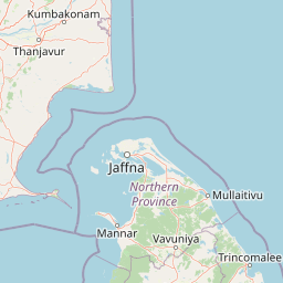
Islands
Park geography
Understanding the marine terrain, coastal islands, and regional scope in Tamil Nadu
Detailed Geographic Profile and Mapped Boundaries of Gulf of Mannar Marine National Park
This geographic profile covers the technical distribution and environmental characteristics of Gulf of Mannar Marine National Park. Data includes mapped boundaries, regional coordinates, and a breakdown of the constituent islands and reef structures contained within the park perimeter across the tropical coastal landscape.
Related tags
marine national parkcoral reefsislandsmarine biodiversitydugong habitat
India's largest marine protected area spanning 21 islands with rich coral reefs and biodiversity
Gulf of Mannar Marine National Park
Gulf of Mannar Marine National Park is a protected coastal and marine area in southeastern India, encompassing 21 small islands and their surrounding coral reefs in the Gulf of Mannar along the Tamil Nadu coastline. The park stretches approximately 160 kilometers between Thoothukudi and Dhanushkodi, lying one to ten kilometers offshore in the Indian Ocean. Established as a National Park in 1980 and formally notified in 1986, it serves as the core zone of the larger Gulf of Mannar Biosphere Reserve, which includes a ten-kilometer buffer zone encompassing populated coastal areas. The park protects a remarkable diversity of marine, intertidal, and near-shore habitats, making it one of India's most biologically rich marine protected areas. Its islands vary dramatically in size from less than one hectare to over 130 hectares, and support ecosystems including coral reefs, seagrass beds, mangrove forests, and seaweed communities.
- Location
- India
- Park type
- National park
- Established
- 1986
- Area
- 560 km²
Location overview
Regional mapping of coastal, island, and marine zones in Tamil Nadu
Gulf of Mannar Marine National Park Geographic Overview
Recorded geographic relationships position the park within Tamil Nadu, India, and American Samoa. Regional status markers define the preserve as an exclusively coastal, island, and marine territory.
- Countries
- India
- Regions
- Tamil Nadu
- Primary location
- Tamil Nadu
- Geographic setting
- Coastal · Island · Marine
Boundary and coordinates
Spatial footprint and coordinate span across 560 square kilometers
Gulf of Mannar Marine National Park Boundary Map and Spatial Limits
A detailed spatial outline provides geographic context and visual orientation for the protected zone. Accompanying geographic records clarify the total area of 560 square kilometers alongside coordinates and center points.
- Boundary area
- 476.7 km²
- Boundary perimeter
- 228.9 km
- Northernmost point
- 9.2565° N
- Southernmost point
- 8.8167° N
- Easternmost point
- 79.2415° E
- Westernmost point
- 78.1917° E
- Geographic centre
- 9.0955° N, 78.6971° E
- North–south span
- 48.6 km
- East–west span
- 115.4 km
Terrain and natural features
Stored lowland classifications and recorded natural features
Gulf of Mannar Marine National Park Terrain and Named Natural Features
This protected area features lowland terrain classifications alongside recorded island, forest, and reef features located within its boundaries. Linked feature cards provide names, types, measurements, and spatial relationships for each recorded entry.
Selected named natural features
Islands
Hare Island
Forests
Kurusadai
Islands
Uppu Thanni
Islands
Nalla Thanni Theevu
Islands
Kariya Challi
Environmental setting
Marine, coastal, and tropical classifications defining the protected geography
Gulf of Mannar Marine National Park Environmental Settings and Landscape Classifications
Recorded habitat types and tropical relief classifications provide structured categories for reading physical park conditions. Associated records link individual environmental attributes to related atlas destinations.
- Relief
- Lowland
- Climate
- Tropical
- Water
- Water-dominated
- Forest cover
- No forest cover
Landscape features
Islands · Coast · Reefs
Habitat types
Marine habitat · Coastal habitat
Park atlas
Browse India's marine protected areas and coastal conservation landscapes across the surrounding region, mapping similar ecosystems.
Explore Other National Parks Near Gulf of Mannar Marine National Park and Coastal Tamil Nadu
After exploring Gulf of Mannar Marine National Park, discover other national parks and protected areas across India's diverse marine and coastal geography, including nearby island chains and rich coral reef systems. Compare conservation efforts, trace regional protected landscapes, and understand the ecological spread of marine biodiversity from this central location.
National parkNorthern Province
About 46 km away#1 closest
Southeast

Adam's Bridge Marine National Park: Protected Coastal Landscape and Geographic Significance
Mapped marine geography and protected island ecosystems.
Adam's Bridge Marine National Park is a protected national park in Sri Lanka's Northern Province, notable for encompassing the legendary Adam's Bridge. This marine protected area safeguards critical shallow-water habitats, including seagrass meadows and sand dunes, which are vital for migratory birds, dugongs, and sea turtles. The park's unique geographic identity as a chain of limestone shoals and islands offers a distinct landscape for atlas-based discovery and understanding of coastal conservation significance.
- Area
- 190 km²
- Established
- 2015
- IUCN
- II
- Relief
- Lowland
National parkNorthern Province
About 57 km away#2 closest
Northeast
Delft National Park: Exploring Its Protected Landscape and Geographic Setting in Northern Province
Mapped boundaries and regional atlas context for this national park.
Delft National Park is a protected natural area situated in Sri Lanka's Northern Province, designated as a national park. This page offers an atlas-focused view of its protected boundaries, helping to contextualize its geographic setting and landscape character. Understanding Delft National Park involves exploring its specific location within the Northern Province and its role as a distinct entity in the study of mapped natural environments and regional geography.
- Area
- 18.46 km²
- Established
- 2015
- IUCN
- II
- Relief
- Lowland
National parkSri Lanka
104 km away#3 closest
Southeast
Wilpattu National Park: Sri Lanka's Largest National Park and Unique Willu Landscape
Explore mapped boundaries and high leopard density geography.
Wilpattu National Park, located in Sri Lanka's northwest coastal lowland dry zone, is the country's largest and one of its oldest national parks. Its landscape is defined by a unique system of nearly 106 natural sand-rimmed water basins, or willu, creating a distinctive wetland environment. The park is globally recognized for its substantial leopard population, representing one of the highest densities recorded in Sri Lanka. Discover the mapped terrain and protected area context of this ecologically vital landscape.
- Area
- 1,316.67 km²
- Established
- 1938
- IUCN
- II
- Relief
- Lowland
National parkNorthern Province
About 112 km away#4 closest
East
Madhu Road National Park: Sri Lanka's Northern Province Dry Zone National Park
Explore protected landscapes and mapped geography.
Madhu Road National Park, situated in Sri Lanka's Northern Province, is a significant protected area defined by its dry zone ecosystems, including forests, grasslands, and wetlands. As one of the island's larger national parks, it offers critical habitat for diverse wildlife and represents an important component of northern Sri Lanka's conservation efforts. This page provides detailed atlas-style insights into the park's geography, mapped boundaries, and its ecological context within the region.
- Area
- 631 km²
- Established
- 2015
- IUCN
- II
- Climate
- Tropical
National parkKerala
About 134 km away#5 closest
West

Periyar National Park: National Park Protected Area Atlas and Geographic Context
Mapped protected lands and regional landscape exploration in Kerala.
Discover Periyar National Park as a distinct protected landscape offering rich geographic context for atlas exploration. This entry details its mapped boundaries and its significance within the broader regional geography of Kerala. Understand the natural terrain and protected-area distribution that makes Periyar National Park a key element in India's conservation mapping.
- Area
- 350.54 km²
- Established
- 1982
- IUCN
- II
- Visitors
- 754.3K annual
Wildlife reserveTamil Nadu
About 135 km away#6 closest
North
Point Calimere Wildlife and Bird Sanctuary: A Coastal Wildlife Reserve in Tamil Nadu
Coastal wetlands, sand dunes, and tidal geography
Located at the tip of the Nagapattinam District, Point Calimere Wildlife and Bird Sanctuary functions as a critical wetland complex along the central Asian flyway. The protected area features a unique intersection of salt swamps, dry evergreen forest fragments, and open coastal horizons. This map-focused profile examines the sanctuary's diverse terrain and its role as a vital sanctuary for blackbuck and thousands of migratory waterbirds.
- Area
- 21.47 km²
- Established
- 1967
- IUCN
- IV
- Relief
- Lowland
National parkNorthern Province
About 142 km away#7 closest
East
Chundikkulam National Park: Protected Landscape Identity and Geographic Atlas
Mapped park boundaries within Northern Province's regional geography.
Chundikkulam National Park stands as a protected landscape within Sri Lanka's Northern Province. This atlas entry provides structured details on its protected area status, allowing for a clear understanding of its geographic position and mapped boundaries. Explore the contextual geography and natural landscape features that define this significant national park, offering a factual basis for discovery.
- Area
- 196 km²
- Established
- 2015
- IUCN
- II
- Relief
- Lowland
National parkIndia
About 169 km away#8 closest
Northwest
Pampadum Shola National Park: India's Protected Area Landscape Details
Explore mapped terrain and geographic context for this national park.
Gain insight into Pampadum Shola National Park, a key protected area within India's geography. This park detail provides essential information on its designation as a national park, its mapped boundaries, and its contribution to the regional landscape. It serves as a vital point for understanding the distribution and character of protected lands across India, offering a foundation for structured geographic research and atlas-based discovery of natural environments.
MoriAtlas Explorer
Continue Exploring the Geographic Identity of Gulf of Mannar Marine National Park
Deepen your understanding of Gulf of Mannar Marine National Park's protected landscape by examining its island geography, mapped reef systems, and coastal terrain. Investigate its role as a national park within Tamil Nadu's marine atlas and explore how its protected boundaries contribute to regional biodiversity and conservation efforts. This focused exploration offers valuable insights into the park's unique position and significance.
Browse next
Global natural geography
Explore related park routes
Explore MoriAtlas Global ParksBrowse All MoriAtlas ParksGlobal Park Map DiscoveryMoriAtlas: Browse All CountriesBrowse All MoriAtlas ContinentsNational Park Environment AtlasGrand Canyon National Park AtlasYellowstone National Park AtlasYosemite National Park Atlas and GeographySerengeti National Park AtlasGalápagos National Park Protected LandscapeBanff National Park Geography and AtlasKruger National Park Atlas EntryUluṟu-Kata Tjuṯa National Park AtlasExplore Uluru-Kata Tjuta National Park GeographyPlitvice Lakes National Park AtlasFiordland National Park Protected LandscapeGreat Smoky Mountains National Park AtlasAfghanistan National Parks and Protected AreasAlbania National Parks and Protected AreasAlgeria National Parks and Protected AreasAmerican Samoa National Parks and Protected AreasAndorra National Parks and Protected AreasAngola National Parks and Protected AreasAntarctica National Parks and Protected AreasAntigua and Barbuda Park List