


Mori Atlas logo
Protected areaHokersar

Understanding the hydrological basin, seasonal waterbird patterns, and ecological boundaries of this Jammu and Kashmir wetland

Hokersar Protected Area: A Comprehensive Geographic and Landscape Analysis of the Kashmir Valley Wetland

Hokersar serves as a vital wetland conservation area within the Jhelum River basin of the Kashmir Valley. Situated at an elevation of 1,584 metres, this reserve acts as a critical staging ground for migratory waterbirds traveling the Central Asian Flyway and functions as an essential flood-absorption basin for snowmelt runoff. The landscape features a tripartite structure of open water, marsh, and silted pasture, creating a dynamic environment that shifts significantly with seasonal hydrological pulses.

wetlandbird sanctuaryKashmir ValleyRamsar siteCentral Asian Flywaymigratory waterbirds
A flat-style digital illustration depicting a calm wetland landscape with tall grasses, trees in the midground, and purple-hued hills under a pastel sky.

Hokersar

Protected area

Park overview

Structured park overview, official facts, and landscape profile for Hokersar

Hokersar park facts, protected area profile, and essential visitor context

Review the core facts for Hokersar, including designation, size, terrain, visitor scale, habitats, and operating context in one park-focused overview.

About Hokersar

Hokersar occupies a defining position in the wetland geography of the Kashmir Valley. Located near Zainakote in Srinagar district, it forms part of the upper Jhelum basin and represents the northernmost portion of the Doodhganga catchment. The reserve sits on the valley floor at approximately 1,584 metres above sea level, framed by the Pir Panjal mountains whose snowmelt feeds the wetland each spring through the Doodhganga and Sukhnag streams.

Ecologically, Hokersar is shaped by seasonal water fluctuation more than by any single habitat type. In winter, its open water and reed-fringed margins attract enormous numbers of migratory waterfowl. In spring, snowmelt raises water levels substantially, and the reserve functions as a natural absorption basin for floodwaters moving down from the surrounding mountains. This dual role as both a bird habitat and a flood buffer gives the wetland a distinctive regional importance.

The site is divided into three ecological zones: a northeastern zone of dense macrophyte growth, a central open-water expanse dominated by species like water chestnut and common reed, and a silted southern area used largely as pasture. The diversity of these zones in a relatively compact area allows Hokersar to support very high densities of wintering birds, including species of global conservation concern.

Beyond its ecological profile, Hokersar is a cornerstone of Kashmir's wildlife-protection framework. It is the largest bird reserve in the valley, is administered by the Jammu and Kashmir Department of Wildlife Protection, and is one of three major Jhelum basin wetlands that have been formally declared bird sanctuaries alongside Haigam and Shallabugh. Its long-running protection status and its recognition under both Indian national programmes and international conventions give Hokersar an unusually strong standing among India's inland wetlands.

Quick facts and research context for Hokersar

Hokersar is a 1,375-hectare wetland conservation reserve and designated bird sanctuary near Srinagar, Jammu and Kashmir, in the Kashmir Valley. It sits at about 1,584 metres elevation in the Jhelum River basin, fed by the Doodhganga and Sukhnag streams, and was recognised as a Ramsar site in 2005 under the name Hokera Wetland. The reserve is administered by the Jammu and Kashmir Department of Wildlife Protection and forms part of the Central Asian Flyway network of important waterbird habitats.

Protection and recognition

Examine the designated year, management scope, and international recognition records for Hokersar.

Hokersar Protection Status and Terrestrial Conservation Designation Records

Terrestrial protection status for Hokersar is formally established under records dating from 2005. Systematic conservation tracking compiles documented management scope and official designation history for reliable reference.

Protection details

Protection scope
Terrestrial
Designated year
2005
Transboundary protection
No
Park context

Deeper park guide and search-rich context for Hokersar

Hokersar history, landscape, wildlife, and travel context

Explore Hokersar through its history, landscape character, ecosystems, wildlife, conservation priorities, cultural context, and seasonal travel timing in a structured park guide built for atlas discovery and search intent.

Why Hokersar stands out

Hokersar is best known as the principal wintering and staging site for migratory waterbirds in the Kashmir Valley, regularly hosting very large numbers of ducks, geese, cranes, and shorebirds that move along the Central Asian Flyway. The reserve is also recognized for its tripartite wetland structure of open water, marsh, and silted pasture, and for its role in absorbing floodwaters from snowmelt in the surrounding Pir Panjal range. Together these qualities have established Hokersar as both a local conservation landmark and an internationally listed Ramsar wetland.
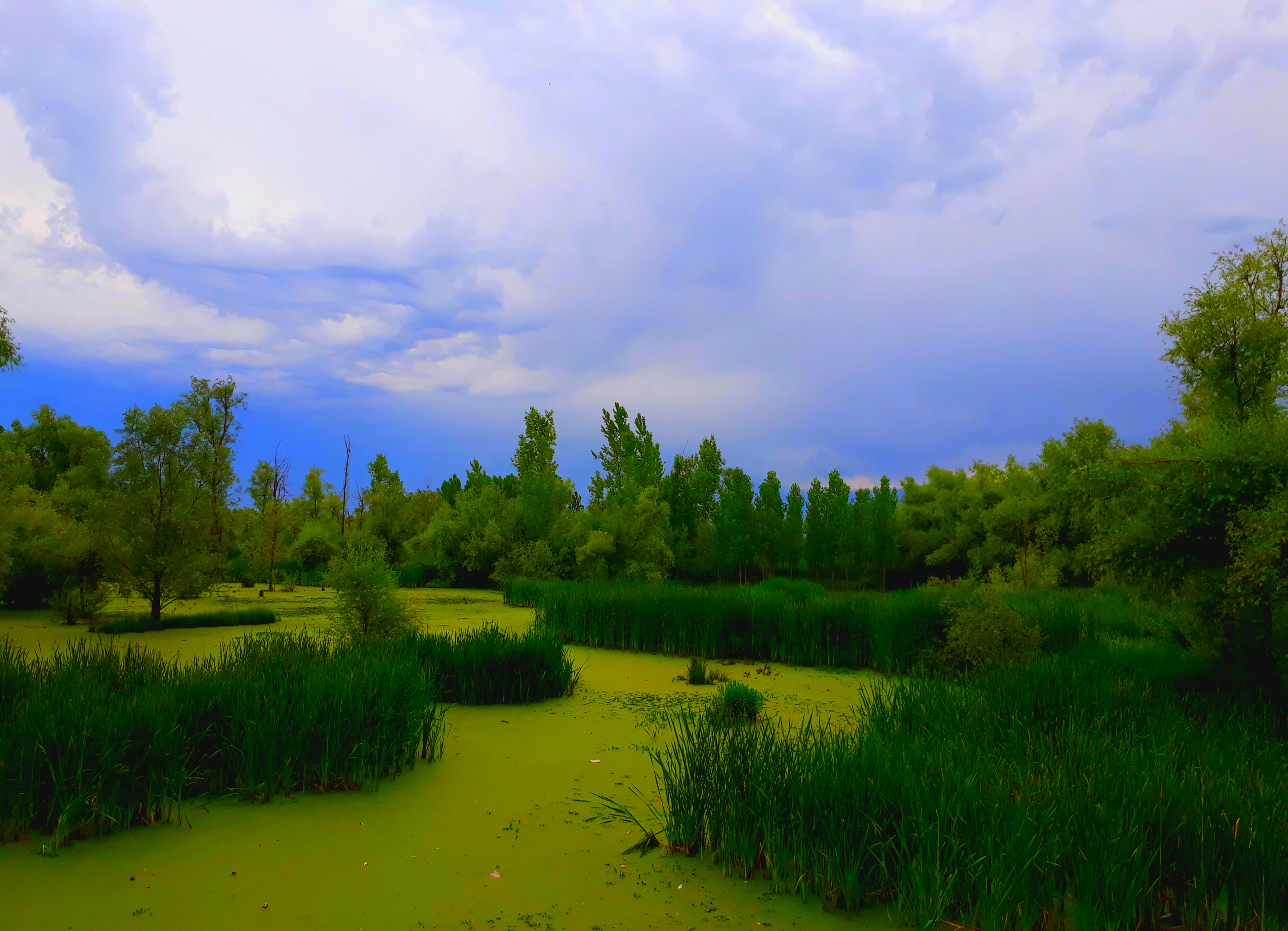
A peaceful landscape view of a green, reed-filled wetland under a blue, overcast sky, surrounded by dense trees.
A wide view of the Hokersar wetland, showcasing the lush reeds and vegetation.

Hokersar history and protected-area timeline

Hokersar's modern protection history begins with its designation as a conservation reserve under the Jammu and Kashmir Wildlife (Protection) Act of 1978. This initial legal recognition established the wetland as a managed protected area rather than an open-access landscape, and laid the groundwork for subsequent conservation measures.

In the years that followed, the reserve was integrated into broader wetland protection efforts at the national level. It became part of India's National Wetlands Conservation Programme and was recognized as an Important Bird Area, reflecting its growing profile among ornithologists and conservation planners.

The most significant international milestone came on 8 November 2005, when Hokersar, listed under the name Hokera Wetland, was designated as a wetland of international importance under the Ramsar Convention. The government of Jammu and Kashmir has also formally declared Hokersar, alongside Haigam and Shallabugh, as a bird sanctuary within the Jhelum basin, consolidating its status as one of the valley's flagship protected wetlands.

Hokersar landscape and geographic character

The Hokersar landscape is a low-elevation valley-floor wetland embedded within the broader Kashmir Valley, encircled by the high ridges of the Pir Panjal range. Sitting at about 1,584 metres above sea level, the terrain is flat to gently undulating, dominated by open water, marshy shallows, reed beds, and silted meadow-like margins rather than dramatic relief.

Two perennial streams shape the hydrology of the site. Doodhganga enters from the east and Sukhnag from the west, feeding the central open-water expanse and maintaining the marshy character of the surrounding zones. Average water depths are shallow, around 0.9 metres, but seasonal snowmelt can raise levels to about 2.4 metres, transforming the reserve into a major flood-absorption basin for runoff descending from the Pir Panjal.

Vegetation divides the wetland into distinct visual and ecological zones. Dense stands of macrophytes occupy the northeastern lobe, while floating plants such as water chestnut and tall reeds like common reed dominate the central open water. To the south, the silted zone reads more like wet pasture, providing a softer, grassy transition between open water and surrounding agricultural land. Together these zones create a layered wetland landscape that shifts visibly with the seasons.

Hokersar ecosystems, habitats, and plant life

Hokersar's ecological character is built around the relationship between water depth, vegetation zones, and seasonal bird use. The reserve's three-zone structure supports a layered habitat mosaic: a heavily vegetated northeastern section dominated by aquatic macrophytes, a central open-water zone rich in floating and emergent plants, and a southern silted area functioning as wet pasture.

Floating species such as water chestnut and emergent reeds like common reed are particularly characteristic of the central zone, giving Hokersar its classic shallow-lake appearance. The vegetated margins and shallow waters create ideal feeding conditions for dabbling ducks and shorebirds, while the more open areas support larger swimming waterfowl such as coots and diving ducks. The seasonal pulse of snowmelt and rainfall resets this habitat annually, refreshing water levels and nutrient cycles.

Ecologically, the reserve functions less as a single habitat and more as a hub within the wider Jhelum basin. Hokersar, together with nearby Haigam and Shallabugh wetlands, forms a network of bird sanctuaries across the valley, each with complementary conditions. This network effect amplifies the regional importance of the Kashmir Valley as a seasonal stronghold for waterbirds and reinforces Hokersar's role as the valley's primary wetland sanctuary.

Hokersar wildlife and species highlights

Hokersar is defined above all by its wintering waterbirds, which arrive along the Central Asian Flyway from breeding grounds in Siberia and Central Asia between September and October and depart by May. The reserve's combination of open water, marsh, and pasture allows it to support a wide spectrum of species in a relatively limited area.

Dabbling ducks dominate the winter bird community. Northern pintail, mallard, gadwall, northern shoveler, Eurasian wigeon, and common teal are among the most numerous species recorded at the site, often present in flocks numbering in the tens of thousands. Coots, red-crested pochard, greylag goose, common pochard, garganey, and ruddy shelduck add further structure to the waterfowl assemblage, alongside occasional cranes and a variety of shorebirds that use the wetland as a stopover or wintering ground.

Survey work has documented more than 45 waterbird species and over 66 wetland-associated bird species in the reserve, including several globally threatened taxa. The sheer seasonal concentration of birds at Hokersar rivals that of much larger wetland complexes elsewhere in South Asia, making the site disproportionately important for waterbird conservation in the Indian subcontinent.

Hokersar conservation status and protection priorities

Hokersar's conservation significance rests on its long-standing protected status and on its position within national and international wetland frameworks. The reserve was first designated under the Jammu and Kashmir Wildlife (Protection) Act of 1978, and it has since been formally recognized as a bird sanctuary alongside Haigam and Shallabugh within the Jhelum basin wetland network.

At the international level, the site's Ramsar designation in 2005 placed Hokersar on the list of wetlands of international importance, while its inclusion in the Important Bird Area network and India's National Wetlands Conservation Programme reflects its role in broader migratory bird and wetland strategies. The reserve is also notable for hosting globally threatened waterbird species, giving it tangible conservation value beyond administrative recognition.

Conservation management at Hokersar faces ongoing pressures from encroachment, agricultural conversion of marsh into paddy fields, and water-quality decline linked to domestic waste inputs through the inlet streams. Reduced water depth during parts of the year has favored excessive macrophyte growth and eutrophication, both of which require active management to preserve the ecological balance that makes the wetland attractive to waterbirds.

Top sights and standout views in Hokersar

Hokersar stands out as the largest and most ecologically prominent bird reserve in the Kashmir Valley, set in the Jhelum basin at about 1,584 metres elevation and fed by the Doodhganga and Sukhnag streams. Its seasonal pulse of snowmelt-driven flooding and winter concentration of Palearctic waterbirds gives it a distinctive dual identity as both a flood-buffering wetland and a migratory bird sanctuary.

The reserve's internationally recognized status, including its 2005 Ramsar designation and its place within India's Important Bird Area network, underscores its role as a flagship site for wetland conservation in the western Himalayas and as a key node in the Central Asian Flyway.

Best time to visit Hokersar

Hokersar is best experienced in winter, when migratory waterbirds from Siberia and Central Asia arrive via the Central Asian Flyway, typically between September–October and May. Peak waterfowl numbers during the coldest months offer the most dramatic birdwatching conditions, with large flocks of dabbling ducks, geese, and coots concentrated across the open water and marsh zones.

Outside the winter season the wetland transforms as snowmelt raises water levels and reshapes habitats, which can reduce visibility into reed beds and shift bird activity away from accessible margins. For visitors focused on landscapes rather than birdwatching, late spring and summer reveal a different, more vegetated wetland character, while winter remains the defining season for understanding why Hokersar matters ecologically.
Monthly climate preview

Long-term representative averages tracking temperature swings and precipitation rhythm across the year

Hokersar Climate Normals, Annual Temperature and Monthly Precipitation Patterns

Hokersar exhibits measured monthly temperature variation alongside recorded long-term precipitation normals at its baseline coordinate point. Examining the complete twelve-month profile clarifies annual weather patterns and sustained meteorological trends across the protected terrain.
Annual mean9 °C
-2 °C19 °C
Jan-2°
Feb-1°
Mar
Apr
May14°
Jun18°
Jul19°
Aug18°
Sep15°
Oct10°
Nov
Dec
Warmest month
July

19.1 °C

Coolest month
January

-2.3 °C

Wettest month
March

3.1 mm/day

Driest month
October

0.7 mm/day

Park location guide

Geography guide, regional context, and park location map for Hokersar

Hokersar park geography, regions, and map view in India

Understand where Hokersar sits in India through a broader geographic reading of the surrounding landscape, nearby location context, and its mapped position within the national park landscape.

How Hokersar fits into India

India is a South Asian country bordered by the Indian Ocean, Arabian Sea, and Bay of Bengal. It shares land borders with Pakistan, China, Nepal, Bhutan, Bangladesh, and Myanmar. The country has a population of over 1.4 billion people and operates as a federal parliamentary republic with its capital in New Delhi.

Wider geography shaping Hokersar in India

India occupies the Indian subcontinent in South Asia, bordered by the Arabian Sea to the southwest, the Bay of Bengal to the southeast, and the Indian Ocean to the south. It shares land borders with Pakistan to the west, China, Nepal, and Bhutan to the north, and Bangladesh and Myanmar to the east. The territory also includes the Andaman and Nicobar Islands in the Indian Ocean.

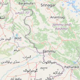
Map view of Hokersar

Use this park location map to pinpoint Hokersar in India, understand its exact geographic position, and read its mapped placement within the surrounding landscape more clearly.

Pigeon | © OpenStreetMap contributors

Location context for Hokersar

Jammu and Kashmir

Explore protected-area views, wetland habitats, and seasonal terrain characteristics across the reserve.

Hokersar Photos and Landscape Scenery: Visualizing the Kashmir Valley Wetland Reserve

Visual documentation of Hokersar reveals the intricate network of open water, marshy shallows, and silted pastures defining the Kashmir Valley. Examining protected-area photography provides clear insight into seasonal hydrology, reed beds, and the distinct valley-floor environment.

A peaceful landscape view of a green, reed-filled wetland under a blue, overcast sky, surrounded by dense trees.

Park atlas

Compare regional wetland reserves and connected conservation landscapes

Explore Parks Near Hokersar and Protected Areas Across the Surrounding Region

Visitors exploring Hokersar can browse adjacent protected areas and regional wetland reserves across the surrounding valley geography. Broadening the geographic scope reveals connected conservation landscapes and similar valley floor habitats.
National parkJammu and Kashmir
About 9 km away#1 closest

East

Salim Ali National Park: Mapped Protected Landscape in Jammu and Kashmir

National Park with distinct geographic and regional atlas context.

Salim Ali National Park is a recognized national park situated in the Jammu and Kashmir region. This entry provides specific insights into its designation as a protected area, focusing on its mapped geographic footprint and its contribution to the regional atlas of conservation lands. Understand the park's landscape context and its place within the broader geography of northern India, offering a detailed perspective for geographic exploration.

Area
9.07 km²
Established
1986
IUCN
II
Climate
Temperate
National parkSrinagar district
About 31 km away#2 closest

East

Dachigam National Park: Protected Landscape Atlas and Geographic Context in Srinagar District

Mapped boundaries and natural terrain within India's national park system.

Gain insight into Dachigam National Park, a significant protected area located in the Srinagar district. This page provides detailed geographic context and an atlas-style view of its protected landscape. Understand its specific role as a national park and explore its mapped features, contributing to a comprehensive understanding of India's natural territories.

Area
141 km²
Established
1910
IUCN
II
Relief
Mountain
Nature reserveJammu and Kashmir
About 33 km away#3 closest

Northwest

Wular Lake Nature Reserve: Protected Wetland and Freshwater Geography in the Kashmir Valley

Tectonic freshwater lake and Ramsar-recognized protected area.

Wular Lake stands as one of the largest freshwater bodies in South Asia, characterized by its tectonic origin and its role as a critical component of the Jhelum River catchment. The protected nature reserve landscape currently encompasses a mosaic of open water, reed beds, and muddy shallows that provide habitat for endemic snowtrout and migratory bird populations throughout the Kashmir Valley.

Established
1990
Relief
Lowland
Climate
Temperate
Scope
Terrestrial
National parkBaramulla district
About 63 km away#4 closest

West

Kazinag National Park: Protected Area Geography and Mapped Boundaries in Baramulla District

Explore the regional landscape and terrain of this national park.

Kazinag National Park represents a distinct protected area within India's Baramulla district. This entry provides structured geographic information, focusing on the park's mapped boundaries and its role as a national park. Users can explore its landscape context and understand its specific regional terrain, contributing to a comprehensive atlas view of protected lands.

Area
160 km²
Established
1992
IUCN
II
Relief
Mountain
National parkPakistan
About 71 km away#5 closest

North

Gurez National Park: Pakistan's Alpine Protected Landscape and Wildlife Habitat

Explore its mapped terrain and regional geographic context.

Gurez National Park stands as a protected national park within Pakistan's breathtaking Himalayan mountain system. This park is crucial for conserving the endangered musk deer and safeguarding a fragile alpine ecosystem characterized by dramatic valleys, steep peaks, and the flowing Kishenganga River. Its relative isolation preserves a unique natural landscape and traditional cultural heritage, making it a point of interest for understanding remote wilderness and conservation efforts within the South Asian atlas.

IUCN
II
National parkGilgit-Baltistan
About 84 km away#6 closest

Northeast

Himalaya National Park: Exploring Its Protected Boundaries and Mountainous Landscape in Gilgit-Baltistan

Mapped protected area within Pakistan's northern mountain region.

Himalaya National Park serves as a significant protected entity within the dramatic geography of Gilgit-Baltistan, Pakistan. This national park offers a focused view of its specific natural terrain and mapped boundaries, contributing to a broader atlas of conservation lands. Users can discover the park's role as a protected landscape, examining its integration within the regional context and understanding its unique geographic characteristics. The focus here is on the park's protected status and its place in the mapped natural environment of Northern Pakistan.

Area
2,263 km²
Established
2021
IUCN
II
Relief
Mountain
National parkAzad Kashmir
About 90 km away#7 closest

West

Panjal Mastan National Park: High-Altitude Plateau Landscape in Azad Kashmir

Discover mapped terrain and protected area geography.

Panjal Mastan National Park represents a significant protected landscape within the Pir Panjal mountain range of Azad Kashmir, Pakistan. This national park is characterized by its expansive high-altitude plateau, sitting at an average elevation of 2,800 meters, offering a unique regional geography. Known for its dramatic mountainous surroundings and seasonal wildflower meadows that bloom in spring, the park provides valuable context for understanding the natural terrain and protected area distribution in this part of the western Himalayas.

Area
300 km²
IUCN
II
Relief
Mountain
Climate
Alpine
National parkAzad Jammu and Kashmir
About 95 km away#8 closest

Southwest

Poonch River Mahaseer National Park: Pakistan's First Riverine Conservation Area

Mapped aquatic landscape and freshwater biodiversity in Azad Jammu and Kashmir.

Poonch River Mahaseer National Park is a significant aquatic protected area established in 2010, renowned for being Pakistan's first dedicated riverine conservation zone. Situated along the Poonch River in Azad Jammu and Kashmir, it spans approximately 22.5 square kilometers, encompassing the main river channel and key tributary nullahs crucial for breeding. The park's primary objective is to protect the endangered golden mahseer and the broader freshwater ecosystem, serving as a vital model for river-based conservation and mapped biodiversity stewardship in the region.

Area
22.5 km²
Established
2010
IUCN
II

Common questions about visiting, size, designation, and location context for Hokersar

Hokersar FAQs for park facts, access, geography, and protected area context

Find quick answers about Hokersar, including protected-area facts, park geography, trail and visitor context, and how the park fits into its surrounding country and regional landscape.
MoriAtlas Explorer

Continue Your Protected Areas Search Across the Global Atlas

Deepen your exploration by continuing the structured search for national parks and protected areas worldwide. Utilize the comprehensive filtering capabilities to compare different conservation landscapes and refine your understanding of global park geography. Discover more about the distribution and characteristics of protected natural areas.

Global natural geography
