
Glaciers
Park geography
A detailed look at the alpine terrain, glacial features, and administrative scope.
Geographic Profile and Mapped Boundaries of Jostedalsbreen National Park in Vestland, Norway
This geographic profile details the physical scope of Jostedalsbreen National Park, covering an area of 1310 square kilometers within the Vestland region of Norway. It presents structured data on elevation, including a maximum height of 2083 meters, and maps the distribution of significant peaks and glacial viewpoints such as Lodalskåpa and Briksdalsbreen.
Related tags
Glacial landscapesAlpine environmentsNorwayIUCN Category IIProtected areas
Europe's largest mainland glacier preserved in dramatic alpine terrain
Jostedalsbreen National Park
Jostedalsbreen National Park is a protected area in western Norway that encompasses the largest glacier on the European mainland. Established in 1991 and expanded in 1998, the park covers 1,310 square kilometres across five municipalities in Vestland county. The park is centred on Jostedalsbreen, a massive ice mass that dominates the landscape and has shaped the surrounding terrain over millennia. The glacier system covers approximately 800 square kilometres of the park's total area, flowing from heights of over 2,000 metres down to valley floors. The protected area preserves not only the glacier itself but also the dramatic mountain landscape of the Jostedalen region, including peaks, valleys, and the geological legacy of glacial advance and retreat. The park holds IUCN Category II designation, reflecting its national significance as a conservation area and its value for scientific study, education, and public appreciation of glacial environments.
- Location
- Norway
- Park type
- National park
- Established
- 1991
- Area
- 1,310 km²
- Highest point
- 2,083 m
Location overview
National and regional placement within the Vestland county of Norway
Geographic Setting of Jostedalsbreen National Park in Norway
Jostedalsbreen National Park is situated entirely within the Vestland region of Norway. As a single-country protected area, it features no marine, coastal, or transboundary territory.
- Countries
- Norway
- Regions
- Vestland
- Primary location
- Vestland
- Geographic setting
- Inland
Boundary and coordinates
Geographic dimensions and spatial extent covering 1310 square kilometers.
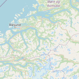
Jostedalsbreen National Park Boundary Map and Spatial Extent
Mapped boundary geometry outlines the physical limits of the protected area to provide essential spatial context. Calculated geographic facts detail the estimated total area, perimeter, coordinate limits, and central points.
- Boundary area
- 1,308.5 km²
- Boundary perimeter
- 433.4 km
- Northernmost point
- 61.9108° N
- Southernmost point
- 61.361° N
- Easternmost point
- 7.4349° E
- Westernmost point
- 6.4475° E
- Geographic centre
- 61.6645° N, 6.9815° E
- North–south span
- 61.3 km
- East–west span
- 52.4 km
Elevation and terrain
Mountain relief range, peaks, glaciers, and recorded natural features
Jostedalsbreen National Park Terrain and Elevation Profile
This park terrain overview details the recorded elevation range and mountain relief metrics spanning the protected area. Individual feature cards list glaciers, peaks, and waterways located within the regional boundary.
- Minimum elevation
- 350 m
- Maximum elevation
- 2,018 m
- Highest point
- 2,083 m
Selected named natural features
Glaciers
Røykjedalsbreen
Waterfalls
Austre Tindefjellsfossen
Streams
Spirefossa
Peaks
Skyttarpiggen
1,411 m
Streams
Tverradøla
Environmental setting
Subpolar climate zones, glacial relief, and alpine meadow habitats across mountain terrain
Jostedalsbreen National Park Environmental Classifications and Physical Settings
Stored landscape features, habitat types, and climate categories provide complementary ways to examine the physical setting of Jostedalsbreen National Park. Recorded classifications link directly to related environmental records within the broader protected area atlas.
- Relief
- Mountain
- Climate
- Subpolar
- Water
- Major water bodies
- Forest cover
- No forest cover
- Seasonality
- Seasonal
Landscape features
Mountains · Glacier
Habitat types
Glacial habitat · Alpine meadow
Park atlas
Compare glacial landscapes, mountain parks, and protected regions across Western Norway's Vestland county.
Explore Nearby National Parks and Protected Areas Surrounding Jostedalsbreen in Vestland, Norway
Continue your park discovery beyond Jostedalsbreen National Park by browsing other national parks and protected areas across Norway's Vestland county. Compare varied glacial, fjord, and mountain protected landscapes, tracing the geographic spread of conservation efforts throughout this distinctive Western Norwegian terrain.
National parkInnlandet
Mapped location lies within the park boundary#1 closest
Northeast

Breheimen National Park: Protected Glacial Landscapes and Mountain Terrain in Innlandet
Norway's prominent national park featuring active glaciers and alpine geography.
Breheimen National Park represents a significant protected landscape within Norway's Innlandet region, dedicated to conserving its unique glacial formations and dramatic alpine terrain. The park's vast area encompasses active glaciers, soaring peaks, and a notable diversity of natural environments, from lush valleys to barren plateaus. MoriAtlas facilitates a detailed exploration of Breheimen National Park, highlighting its mapped protected boundaries and its integral role in the regional geography and protected areas atlas.
- Area
- 1,671 km²
- Established
- 2009
- IUCN
- II
- Relief
- Mountain
National parkNorway
28 km away#2 closest
East
Jotunheimen National Park: Norway's Iconic Alpine Protected Landscape and Geographic Core
Explore mapped glacial terrain and alpine geography.
Jotunheimen National Park stands as a monument to Norway's alpine grandeur, protecting over 1,151 square kilometers of spectacular mountainous terrain. This protected area is defined by its dramatic glacial features, including sharp peaks exceeding 1,900 meters, U-shaped valleys, and pristine alpine lakes, making it a significant focus for geographic exploration and mapped landscape study. Delve into the core of Norway's mountain heartland, understanding the mapped boundaries and regional geological context that shape this iconic protected landscape.
- Area
- 1,151 km²
- Established
- 1980
- IUCN
- II
- Relief
- Mountain
National parkInnlandet
About 47 km away#3 closest
Northeast
Reinheimen National Park: Norway's Vast Protected Wilderness Landscape and Alpine Geography
Map of protected boundaries and diverse mountain terrain.
Reinheimen National Park is a cornerstone of Norway's protected areas, encompassing a substantial portion of Western Norway's alpine wilderness. This national park protects a dynamic landscape characterized by dramatic western peaks and gentler eastern plateaus, providing critical habitat for wild reindeer and other wildlife. Its extensive mapped boundaries and varied natural terrain offer a rich subject for geographic discovery and atlas exploration, highlighting the ecological significance of well-preserved mountain ecosystems within Innlandet.
- Area
- 1,969 km²
- Established
- 2006
- IUCN
- II
- Relief
- Mountain
National parkInnlandet
82 km away#4 closest
Northeast
Dovrefjell, Sunndalsfjella National Park: Mapping Norway's Largest Alpine Protected Landscape
Explore its protected boundaries, mountain terrain, and unique ecological significance.
Dovrefjell, Sunndalsfjella National Park is a cornerstone of Norwegian protected areas, offering an expansive alpine wilderness with dramatic mountain scenery. This page details the park's geographic context, mapped landscape features, and its importance as a refuge for unique wildlife like wild reindeer and muskox. Users can investigate the park's protected boundaries and understand its role within the regional geography of Innlandet, contributing to a structured atlas of Scandinavia's natural heritage.
- Area
- 1,693 km²
- Established
- 2002
- IUCN
- II
- Relief
- Mountain
National parkNorway
About 94 km away#5 closest
South
Hallingskarvet National Park: Norway's High Mountain Plateau and Protected Wilderness
Mapping glacial terrain, alpine environments, and wild reindeer habitat.
Hallingskarvet National Park offers a unique window into Norway's geological history and alpine ecology. This protected landscape encompasses the striking Hallingskarvet plateau and the Vargebreen glacier, along with deep valleys carved by ancient ice. Users can explore the park's mapped boundaries, understand its regional geographic setting in Scandinavia, and appreciate its conservation value as a habitat for wild reindeer. The park's terrain provides a concrete example of glacial shaping and high-altitude ecosystems within the Nordic context.
- Area
- 450 km²
- Established
- 2006
- IUCN
- II
- Relief
- Mountain
Protected landscapeInnlandet
About 101 km away#6 closest
Northeast
Fokstugu landskapsvernområde: Alpine Protected Landscape and Regional Ecological Corridor
A vital bridge for mountain migration in Innlandet, Norway.
Fokstugu landskapsvernområde protects a unique mix of alpine terrain, geological formations, and cultural mountain heritage across the Dovrefjell plateau. Serving as a connective corridor between major national parks, this protected area maintains essential migratory paths for wild reindeer and preserves traditional Norwegian upland farming features.
- Area
- 72.3 km²
- Established
- 2002
- Relief
- Mountain
- Climate
- Alpine
National parkInnlandet
103 km away#7 closest
East
Rondane National Park: Norway's Premier Alpine Protected Landscape and Historic National Park
Mapped glacial terrain, iconic peaks, and wild reindeer sanctuary.
As Norway's first national park, Rondane offers a profound exploration of a protected alpine environment. Situated in Innlandet county, its 963 square kilometers showcase a landscape sculpted by glaciers, featuring a striking array of ten peaks exceeding 2,000 meters. This page details Rondane National Park's distinct mapped boundaries, dramatic mountain geography, and its ecological significance as a refuge for wild reindeer, making it a cornerstone of Scandinavian natural heritage.
- Area
- 963 km²
- Established
- 1962
- IUCN
- II
- Relief
- Mountain
National parkVestland
110 km away#8 closest
South
Hardangervidda National Park: Vast Arctic Plateau and European Peneplain Discovery
Explore Norway's largest national park and its unique tundra ecosystem.
Delve into the geography of Hardangervidda National Park, Norway's largest national park, featuring the expansive Arctic plateau and Europe's largest peneplain. This protected landscape offers a unique mapped environment characterized by treeless moorland, numerous lakes, and important wildlife habitats, including significant wild reindeer populations. Understand its position within the Vestland region and its value as a key protected area for geographic exploration and landscape context.
- Area
- 3,422 km²
- Established
- 1981
- IUCN
- II
- Relief
- Highland
MoriAtlas Explorer
Continue exploring the mapped geography of Jostedalsbreen National Park
Delve deeper into the geographic context and protected landscape of Jostedalsbreen National Park. Understand how this significant glacial region fits within the broader atlas of Norway's protected areas and discover the unique terrain shaped by its massive ice fields. MoriAtlas provides structured data to enhance your exploration of these important natural environments.
Browse next
Global natural geography
Explore related park routes
Explore MoriAtlas Global ParksBrowse All MoriAtlas ParksGlobal Park Map DiscoveryMoriAtlas: Browse All CountriesBrowse All MoriAtlas ContinentsNational Park Environment AtlasGrand Canyon National Park AtlasYellowstone National Park AtlasYosemite National Park Atlas and GeographySerengeti National Park AtlasGalápagos National Park Protected LandscapeBanff National Park Geography and AtlasKruger National Park Atlas EntryUluṟu-Kata Tjuṯa National Park AtlasExplore Uluru-Kata Tjuta National Park GeographyPlitvice Lakes National Park AtlasFiordland National Park Protected LandscapeGreat Smoky Mountains National Park AtlasAfghanistan National Parks and Protected AreasAlbania National Parks and Protected AreasAlgeria National Parks and Protected AreasAmerican Samoa National Parks and Protected AreasAndorra National Parks and Protected AreasAngola National Parks and Protected AreasAntarctica National Parks and Protected AreasAntigua and Barbuda Park List