
Peaks
Park geography
Examining the island, coastal, and marine landscape features within this protected area
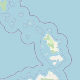
Comprehensive Geographic Profile and Mapped Boundaries of Kent Group National Park in Tasmania
This geographic profile details the physical scope and environmental structure of Kent Group National Park in Tasmania. The park covers 312.83 square kilometers, with a significant marine-to-land ratio defined by its island setting. Discover specific topographical data including named bays, bluffs, and peaks within the documented boundaries.
Related tags
Island national parkMarine reserveBass StraitTasmaniaTemperate marine ecosystems
Remote Tasmanian islands and marine reserve in Bass Strait
Kent Group National Park
Kent Group National Park protects a collection of islands situated in Bass Strait between mainland Australia and Tasmania. The park encompasses both the terrestrial islands, covering approximately 23.74 square kilometers, and a surrounding marine reserve area of roughly 290 square kilometers, making it one of the larger protected marine environments in temperate Australia. Established in April 1971, the park represents a significant conservation effort to preserve the unique ecosystems of these isolated island landscapes and the productive waters that surround them. The islands themselves are characterized by rugged coastal terrain, heathlands, and forests adapted to the exposed maritime environment. The marine component of the park is particularly notable, influenced by the convergence of the East Australian Current and the cooler waters of Bass Strait, creating a biologically rich marine environment with high fish diversity. The park holds particular significance for its Aboriginal heritage, with archaeological evidence indicating continuous human occupation of the islands for thousands of years. Beyond its ecological importance, Kent Group National Park represents one of the more remote and lesser-visited protected areas in southeastern Australia, offering a distinctive island wilderness experience distinct from the mainland and larger Tasmanian national parks. The park's isolation has helped preserve both natural values and cultural heritage, making it a meaningful representative of Bass Strait island ecosystems.
- Location
- Australia
- Park type
- National park
- Established
- 1971
- Area
- 312.8 km²
Location overview
Island and marine protected area status in Tasmania, Australia
Exploring the Geography of Kent Group National Park in Tasmania
Kent Group National Park is located within the regional territory of Tasmania in Australia. Geographic records classify the coastal reserve as an island park with marine protections.
- Countries
- Australia
- Regions
- Tasmania
- Primary location
- Tasmania
- Geographic setting
- Coastal · Island · Marine
Boundary and coordinates
Mapping terrestrial and marine limits across 312 square kilometers
Boundary Map and Geographic Limits of Kent Group National Park
Mapped boundary geometry provides essential spatial context for Kent Group National Park. Accompanying geographic records outline the 312 square kilometer division of land and marine zones alongside center coordinates.
- Boundary area
- 314.1 km²
- Boundary perimeter
- 70.8 km
- Northernmost point
- 39.3851° S
- Southernmost point
- 39.5556° S
- Easternmost point
- 147.4472° E
- Westernmost point
- 147.1236° E
- Geographic centre
- 39.4658° S, 147.3203° E
- North–south span
- 18.9 km
- East–west span
- 27.8 km
Terrain and natural features
Mapped islands, peaks, bays, and capes within the protected landscape
Kent Group National Park Terrain and Recorded Named Natural Features
Recorded natural features within Kent Group National Park include multiple named peaks, islands, bays, and capes. Structured feature cards detail individual names, types, and spatial relationships across the protected area.
Selected named natural features
Bays
Little Squally Cove
Islands
South West Isle
Capes
Beagle Point
Islands
Anvil Rock
Peaks
Flag Hill
147 m
Environmental setting
Explore recorded island, coastal, and marine habitat features
Kent Group National Park Environmental Classifications and Physical Setting
Recorded classifications group island and coastal landforms with dominant marine water presence across the protected terrain. Linked categories connect physical setting attributes to corresponding atlas destinations.
- Water
- Water-dominated
Landscape features
Islands · Coast
Habitat types
Coastal habitat · Marine habitat
Park atlas
Trace the regional spread of island national parks and marine protected areas across Bass Strait.
Explore Other National Parks and Protected Areas Near Kent Group National Park
Continue your exploration beyond Kent Group National Park by browsing other national parks and protected areas across the broader Bass Strait region. Compare their unique island landscapes, marine environments, and conservation approaches to deepen your understanding of regional park geography.
Marine protected areaVictoria
Park boundaries overlap#1 closest
Northwest

Beagle Commonwealth Marine Reserve: Mapping Bass Strait and Victorian Marine Protected Areas
Submerged continental shelf and Bassian Plain geography
The Beagle Commonwealth Marine Reserve protects nearly 3,000 square kilometres of the Bass Strait seabed. This site offers deep insight into the region's submerged landscape history, featuring geological remnants of the ancient Bassian Plain and a series of rugged island archipelagos that frame this temperate marine environment.
- Area
- 2,928 km²
- Established
- 2007
- IUCN
- VI
- Relief
- Lowland
National parkAustralia
73 km away#2 closest
Northwest
Wilsons Promontory National Park: Southernmost Australian National Park with Granite Landscapes and Rainforests
Mapped geography of a dramatic coastal and wilderness park.
Wilsons Promontory National Park, situated at Australia's southern mainland extremity, represents a significant protected landscape. The park's geography is defined by ancient granite formations, creating dramatic peaks and headlands that meet the Bass Strait. Within its boundaries, diverse ecosystems flourish, including rare temperate rainforests and heathy woodlands. This page provides detailed geographic context and atlas-style discovery for this iconic protected area.
- Area
- 505 km²
- Established
- 1898
- IUCN
- II
- Relief
- Mixed relief
Marine protected areaAustralia
74 km away#3 closest
West
Wilsons Promontory Marine National Park: Australia's Southern Marine Protected Landscape
Explore mapped boundaries and island ecosystems at the edge of Bass Strait.
Wilsons Promontory Marine National Park, a 15,500-hectare marine protected area in Victoria, Australia, offers unique atlas exploration of its coastal and island geography. The park's waters surround the Glennie and Anser island groups, showcasing a complex marine terrain where Bass Strait transitions into the Southern Ocean. It complements the adjacent terrestrial national park, creating a comprehensive protected landscape vital for marine biodiversity and regional geographic context. Discover its mapped marine environment and ecologically significant island habitats.
- Area
- 155 km²
- Established
- 2003
- IUCN
- II
- Scope
- Marine
National parkTasmania
91 km away#4 closest
Southeast
Strzelecki National Park: A National Park in Tasmania's Protected Landscape Atlas
Explore mapped park boundaries and regional terrain.
Strzelecki National Park represents a significant protected land entity within Tasmania, Australia. As a national park, it offers critical insights into the island state's diverse geography and landscape formations. This detailed view supports an atlas-based understanding, highlighting the park's mapped boundaries and its contribution to the structured exploration of Australia's protected areas. Discover the geographic characteristics and contextual importance of this Tasmanian natural landscape.
- Area
- 42.16 km²
- Established
- 1967
- IUCN
- II
- Relief
- Mixed relief
Marine protected areaAustralia
93 km away#5 closest
Northwest
Corner Inlet Marine National Park: Australian Protected Marine Landscape Atlas
Explore tidal wetlands and marine protected area geography.
Corner Inlet Marine National Park is a designated marine protected area in South Gippsland, Victoria, renowned for its ecological importance as part of a Ramsar-listed wetland. This park encompasses the waters and extensive intertidal zones of Corner Inlet, featuring vital seagrass beds and tidal marshes. Its protected status highlights its significance within Australia's marine park network, offering a clear example of coastal inlet conservation and regional landscape context for map-based exploration.
- Area
- 15.5 km²
- Established
- 2002
- IUCN
- II
- Relief
- Lowland
Marine protected areaAustralia
104 km away#6 closest
North
Ninety Mile Beach Marine National Park: Victoria's Coastal Marine Protected Area
Mapped boundaries and temperate marine landscape context.
Ninety Mile Beach Marine National Park represents a significant commitment to marine conservation along the eastern Victorian coast. This protected area safeguards the underwater ecosystems adjacent to the celebrated Ninety Mile Beach, a nearly 100-kilometer stretch of continuous sandy shoreline. Its establishment in 2002 preserves the marine biodiversity and coastal landscape character of this region, forming an integral part of Victoria's network of protected coastal environments and offering a distinct view of Australia's marine geography.
- Area
- 27.5 km²
- Established
- 2002
- IUCN
- II
- Scope
- Marine
National parkAustralia
118 km away#7 closest
Northwest
Tarra-Bulga National Park: Ancient Mountain Ash Forest Protected Landscape in Victoria
Explore mapped fern gullies and temperate rainforest ecosystems.
Tarra-Bulga National Park is a protected national park in Victoria, Australia, renowned for its spectacular old-growth mountain ash forests and lush fern gullies. This significant fragment of temperate rainforest offers a unique window into the region's natural heritage and geographic past. Discover the mapped landscape character, including towering trees and vibrant undergrowth, making it a key destination for protected-area exploration.
- Area
- 15.22 km²
- Established
- 1986
- IUCN
- II
- Visitors
- 80K annual
National parkAustralia
133 km away#8 closest
Northwest
Morwell National Park: Protected Landscape Diversity in Victoria's Strzelecki Ranges
Explore the mapped terrain and unique forest ecosystems.
Morwell National Park, an Australian national park in the Strzelecki Ranges, is celebrated for its extraordinary plant and animal diversity within a concentrated area. The park preserves critical wet sclerophyll forests and delicate temperate rainforest pockets within deep gullies, offering a distinct landscape character. Its establishment reflects a significant community-driven conservation effort, making it a valuable site for understanding regional protected-area geography and landscape richness.
- Area
- 5.65 km²
- Established
- 1966
- IUCN
- III
- Relief
- Highland
MoriAtlas Explorer
Continue Exploring Kent Group National Park's Tasmanian Geography
Delve deeper into the mapped geography and protected landscape of Kent Group National Park. Understanding its regional context within Tasmania enriches your atlas exploration of Australia's protected areas, providing factual details on its geographic identity and ecological significance without travel advice.
Browse next
Global natural geography
Explore related park routes
Explore MoriAtlas Global ParksBrowse All MoriAtlas ParksGlobal Park Map DiscoveryMoriAtlas: Browse All CountriesBrowse All MoriAtlas ContinentsNational Park Environment AtlasGrand Canyon National Park AtlasYellowstone National Park AtlasYosemite National Park Atlas and GeographySerengeti National Park AtlasGalápagos National Park Protected LandscapeBanff National Park Geography and AtlasKruger National Park Atlas EntryUluṟu-Kata Tjuṯa National Park AtlasExplore Uluru-Kata Tjuta National Park GeographyPlitvice Lakes National Park AtlasFiordland National Park Protected LandscapeGreat Smoky Mountains National Park AtlasAfghanistan National Parks and Protected AreasAlbania National Parks and Protected AreasAlgeria National Parks and Protected AreasAmerican Samoa National Parks and Protected AreasAndorra National Parks and Protected AreasAngola National Parks and Protected AreasAntarctica National Parks and Protected AreasAntigua and Barbuda Park List