

Mori Atlas logo
National parkKent Group National Park

Discover the mapped geography and protected boundaries of this island national park.

Kent Group National Park: Tasmania's Protected National Park Landscape

Kent Group National Park represents a significant protected area within the island state of Tasmania. As a designated national park, it offers crucial insights into the natural landscapes and geographic context of this unique Australian region. The MoriAtlas platform facilitates exploration of its mapped boundaries and its role within Tasmania's extensive network of protected lands, providing a factual atlas-style understanding of its place.

Island national parkMarine reserveBass StraitTasmaniaTemperate marine ecosystemsAboriginal heritage site

Kent Group National Park

National park

Park overview

Structured park overview, official facts, and landscape profile for Kent Group National Park

Kent Group National Park park facts, protected area profile, and essential visitor context
Review the core facts for Kent Group National Park, including designation, size, terrain, visitor scale, habitats, and operating context in one park-focused overview.

About Kent Group National Park

Kent Group National Park occupies a distinctive position among Australian protected areas as a remote island park in Bass Strait, the shallow sea channel separating Tasmania from mainland Australia. The park encompasses the Kent Group islands, a chain of islands that represent some of the more isolated terrestrial environments in southeastern Australia. The combination of island and marine protection within a single park management framework makes Kent Group particularly significant, preserving not only the terrestrial ecosystems but also the productive marine waters that surround the islands.

The park's setting in Bass Strait places it at a biogeographic crossroads, where influences from both mainland Australia and Tasmania converge. The marine environment is especially noteworthy, with the protected waters east of Deal Island supporting diverse fish communities. This marine productivity stems from the interaction between the warm East Australian Current pushing south and the cooler, more turbulent waters of Bass Strait flowing from west to east. The resulting mixing zone creates favorable conditions for marine life, supporting species assemblages characteristic of both warmer and cooler waters.

Terrestrially, the islands feature vegetation communities adapted to the harsh maritime conditions including coastal heathlands, button grass moorlands, and forests dominated by eucalyptus species. The exposed island environment with its strong winds, salt spray, and relatively nutrient-poor soils has shaped distinctive plant communities that differ from mainland Tasmania. These island ecosystems support specialized flora and fauna adapted to isolation, including several endemic species found only in the Bass Strait islands.

Quick facts and research context for Kent Group National Park

Kent Group National Park is located in Bass Strait, protecting the Kent Group islands belonging to Tasmania, Australia. The park covers a total of approximately 312.83 square kilometers including both land and marine areas. The islands themselves total about 23.74 square kilometers while the surrounding marine reserve encompasses roughly 290 square kilometers. The park was officially established on April 28, 1971, and is managed by the Tasmania Parks and Wildlife Service. The park is classified as IUCN Category II, denoting its status as a national park with primary protection for ecological preservation.

Park context

Deeper park guide and search-rich context for Kent Group National Park

Kent Group National Park history, landscape, wildlife, and travel context
Explore Kent Group National Park through its history, landscape character, ecosystems, wildlife, conservation priorities, cultural context, and seasonal travel timing in a structured park guide built for atlas discovery and search intent.

Why Kent Group National Park stands out

Kent Group National Park is best known for its dual terrestrial and marine protected character, representing some of the more isolated island landscapes in southeastern Australia. The park is recognized for its high marine biodiversity, particularly fish species diversity attributed to the mixing of warm East Australian Current waters with the cooler flows of Bass Strait. The islands hold significant Aboriginal heritage with occupation dating back an estimated 8,000 to 13,000 years, making them among the earliest occupied sites in the Bass Strait region. The park is also notable for the historic Deal Island lighthouse, constructed in 1848 and representing one of the earliest European installations in the area.

Kent Group National Park history and protected-area timeline

The history of human occupation at Kent Group spans a significant period, with archaeological evidence indicating Aboriginal presence on the islands dating back between 8,000 and 13,000 years. This makes the Kent Group islands among the longest continuously occupied sites in the Bass Strait region, representing a remarkable continuity of cultural connection to Country for the Aboriginal Tasmanian peoples. The islands would have provided resources including seafood, marine mammals, and birdlife for these early inhabitants.

European interest in the Kent Group islands began with the establishment of sealing operations in the early nineteenth century, making these among the earliest European settlements in Eastern Bass Strait outside Sydney Cove. The economic importance of seal harvesting in the region led to regular seasonal occupation of the islands by sealers. In 1848, a lighthouse was constructed on Deal Island, introducing permanent European habitation to the island group. The lighthouse remained operational until 1992, representing over 140 years of continuous human presence on Deal Island.

Grazing by cattle occurred on parts of the islands until as recently as 1996, representing a relatively recent phase of agricultural use that has since been removed as the islands returned to full protected status. The establishment of the national park in 1971 formalized the conservation protection of these islands, with subsequent expansion of marine protections to create the comprehensive reserve that exists today. This progression from Aboriginal heritage through European exploitation to contemporary conservation reflects the broader narrative of many Australian island environments.

Kent Group National Park landscape and geographic character

The Kent Group islands present a landscape defined by their maritime setting in Bass Strait. The islands feature rocky coastlines with dramatic sea cliffs, wave-cut platforms, and numerous small beaches and coves where the islands meet the sea. The terrain is generally hilly, with the highest points offering panoramic views across the strait toward both mainland Australia and Tasmania.

The coastal landscape is characterized by exposed headlands battered by the often rough waters of Bass Strait, a channel notorious for its unpredictable weather and powerful swells. Inland, the terrain rises to more sheltered areas where heathlands and forests develop. The islands lack the dramatic alpine landscapes found in some Tasmanian parks, instead offering a more intimate scale of exposed island terrain with twisted trees shaped by persistent coastal winds.

The marine landscape surrounding the islands is equally distinctive, with clear waters supporting kelp forests and diverse benthic communities. The sea floor around the islands features a mix of rocky reefs, sandy bottoms, and areas of seagrass, creating varied underwater environments that contribute to the park's marine biodiversity. The productive waters support the fish and marine life that make the marine reserve component so ecologically significant.

Kent Group National Park ecosystems, habitats, and plant life

The nature of Kent Group National Park is defined by its position at a biogeographic boundary between mainland and Tasmanian ecosystems, combined with the unique pressures of an isolated island environment. The park encompasses both terrestrial and marine habitats, each supporting distinctive ecological communities. The marine environment is particularly notable, with the mixing of warm and cool water influences creating conditions favorable for high species diversity, especially among fish communities.

Terrestrial habitats include coastal heathland communities adapted to the harsh, wind-exposed island conditions, button grass dominated moorlands in wetter areas, and eucalyptus forest communities in more sheltered locations. These vegetation types support birdlife including various seabirds that use the islands for nesting, and land birds adapted to island life. The isolation of the islands has led to some species differentiation from mainland populations, reflecting the evolutionary pressures of island isolation.

The marine component of the park represents a significant conservation achievement, protecting productive waters that would otherwise face fishing pressure. The waters around the islands support diverse fish assemblages, marine mammals including seals that haul out on rocky shores, and seabirds that feed in the productive surrounding waters. The prohibition of fishing in the marine reserve area east of Deal Island helps maintain ecological integrity and allows marine communities to function with minimal human disturbance.

Kent Group National Park wildlife and species highlights

Wildlife at Kent Group National Park reflects its dual island and marine character. The marine waters support diverse fish communities, with the park recognized for its high fish species diversity likely attributable to the convergent influences of the East Australian Current and Bass Strait flows. The protected marine environment provides important habitat for commercially and ecologically significant fish species.

Seabirds represent a prominent component of the park's wildlife, with the islands providing nesting habitat for various species that rely on the isolated island environment for breeding success. The surrounding waters offer feeding grounds for pelagic seabirds. Marine mammals, particularly seals, use the rocky coastlines for resting and hauling out, taking advantage of the protected status that limits disturbance in key areas.

On land, the birdlife includes species adapted to heathland and forest habitats, with some populations showing adaptations to the island environment. The islands support both resident bird species and seasonal visitors that utilize the islands as stopover points during migration. The diverse habitats from exposed coastal heath to more sheltered forest patches support varying bird communities across the island group.

Kent Group National Park conservation status and protection priorities

Kent Group National Park represents an important conservation outcome for Bass Strait island ecosystems and the marine environment of the strait. The dual protection of both terrestrial and marine environments within a single protected area framework addresses the interconnected nature of island and ocean ecosystems. The marine reserve component, covering approximately 290 square kilometers, provides meaningful protection for productive waters that might otherwise face significant fishing pressure.

The park's conservation significance is enhanced by its role in protecting Aboriginal cultural heritage, with the islands representing continuous occupation for thousands of years. This cultural dimension adds another layer of conservation value beyond purely ecological considerations. The protection of the islands also preserves geological and geomorphological features that contribute to understanding Bass Strait's evolutionary history.

The progressive removal of grazing pressure, which continued on some island areas until 1996, has allowed ecological recovery and restoration of natural vegetation communities. This recent history of human use means the park continues to benefit from ongoing recovery, with vegetation and soils gradually returning to more natural conditions following the removal of cattle. The long-term management by Tasmania Parks and Wildlife Service ensures ongoing conservation of these significant island and marine environments.

Kent Group National Park cultural meaning and human context

The Kent Group islands hold deep cultural significance for Aboriginal Tasmanian peoples, with archaeological evidence demonstrating continuous human occupation spanning an estimated 8,000 to 13,000 years. This remarkable time depth places the islands among the earliest continuously occupied sites in the Bass Strait region, representing a long and enduring relationship between Aboriginal peoples and this island landscape. The islands would have provided important resources for coastal and maritime subsistence, with the rich marine environment supporting communities over millennia.

European history on the islands began with sealers establishing temporary settlements in the early nineteenth century, making this among the earliest European presence in Eastern Bass Strait. The Deal Island lighthouse, constructed in 1848 and operational until 1992, represents the most substantial period of European habitation and remains an important historical feature of the island group. This layered history, from Aboriginal heritage through colonial exploitation to contemporary conservation, gives the park a complex cultural narrative that contributes to its significance beyond purely natural values.

The islands exist within a broader cultural landscape of Bass Strait, which holds particular importance for Aboriginal Tasmanian communities as the land bridge connecting the island to mainland Australia during lower sea levels. This deep history of connection adds cultural resonance to the contemporary protected status of the Kent Group islands.

Top sights and standout views in Kent Group National Park

Kent Group National Park offers a distinctive combination of remote island wilderness and marine protection that sets it apart from most other Australian national parks. The opportunity to experience the unique Bass Strait island environment, with its rich Aboriginal heritage and European history, provides cultural dimension alongside natural values. The marine reserve component, with its diverse fish communities and productive waters, represents significant conservation protection in the temperate marine environment.

The historical Deal Island lighthouse, operational for over 140 years, remains an evocative feature of the park landscape. The park's relative remoteness and limited visitor infrastructure contribute to a sense of wilderness that contrasts with more accessible protected areas. The convergence of warm and cool water influences in the surrounding marine environment creates conditions supporting exceptional marine biodiversity within the protected waters.

Best time to visit Kent Group National Park

Visiting Kent Group National Park is influenced by the maritime climate of Bass Strait, which can present challenging conditions for travel to the islands. The summer months typically offer more stable weather conditions and calmer seas, making this the most reliable period for accessing the islands. However, Bass Strait is known for its variable conditions, and even during summer periods, weather can change rapidly.

The winter months can bring more active weather systems and rougher seas, potentially limiting access opportunities. However, the island environment has its own character in different seasons, with winter bringing different atmospheric conditions and wildlife viewing opportunities. The park's remote location means that planning around weather windows is an important consideration for any visit.

The shoulder seasons of spring and autumn may offer a balance between more favorable conditions and fewer visitors, though these periods can also present variable weather patterns. Visitors should be prepared for the possibility of weather-related changes to travel plans and should check current conditions before attempting to access the islands.
Park location guide

Geography guide, regional context, and park location map for Kent Group National Park

Kent Group National Park park geography, regions, and map view in Australia
Understand where Kent Group National Park sits in Australia through a broader geographic reading of the surrounding landscape, nearby location context, and its mapped position within the national park landscape.

How Kent Group National Park fits into Australia

Australia is a constitutional monarchy and federal parliamentary democracy comprising six states and ten territories. With a population of nearly 28 million, it is one of the world's most urbanised countries, with most people concentrated on the eastern seaboard. The country has a high Human Development Index and is known for its cultural diversity, ancient Aboriginal heritage, and unique wildlife.

Wider geography shaping Kent Group National Park in Australia

Australia occupies the entire Australian continent, the island of Tasmania, and numerous smaller islands. It is the world's flattest and driest inhabited continent, featuring vast deserts in the interior (the Outback), tropical rainforests along the eastern coast, and a coastline bordering the Indian and Pacific Oceans.

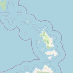
Map view of Kent Group National Park

Use this park location map to pinpoint Kent Group National Park in Australia, understand its exact geographic position, and read its mapped placement within the surrounding landscape more clearly.

Pigeon | © OpenStreetMap contributors

Location context for Kent Group National Park

Tasmania
Park atlas

Trace the regional spread of island national parks and marine protected areas across Bass Strait.

Explore Other National Parks and Protected Areas Near Kent Group National Park
Continue your exploration beyond Kent Group National Park by browsing other national parks and protected areas across the broader Bass Strait region. Compare their unique island landscapes, marine environments, and conservation approaches to deepen your understanding of regional park geography.
Marine protected area

Wilsons Promontory Marine National Park: Australia's Southern Marine Protected Landscape

Explore mapped boundaries and island ecosystems at the edge of Bass Strait.

Wilsons Promontory Marine National Park, a 15,500-hectare marine protected area in Victoria, Australia, offers unique atlas exploration of its coastal and island geography. The park's waters surround the Glennie and Anser island groups, showcasing a complex marine terrain where Bass Strait transitions into the Southern Ocean. It complements the adjacent terrestrial national park, creating a comprehensive protected landscape vital for marine biodiversity and regional geographic context. Discover its mapped marine environment and ecologically significant island habitats.

Area
155 km²
Established
2003
IUCN
II
Scope
Marine
National park

Wilsons Promontory National Park: Southernmost Australian National Park with Granite Landscapes and Rainforests

Mapped geography of a dramatic coastal and wilderness park.

Wilsons Promontory National Park, situated at Australia's southern mainland extremity, represents a significant protected landscape. The park's geography is defined by ancient granite formations, creating dramatic peaks and headlands that meet the Bass Strait. Within its boundaries, diverse ecosystems flourish, including rare temperate rainforests and heathy woodlands. This page provides detailed geographic context and atlas-style discovery for this iconic protected area.

Area
505 km²
Established
1898
IUCN
II
Relief
Mixed relief
National parkTasmania

Strzelecki National Park: A National Park in Tasmania's Protected Landscape Atlas

Explore mapped park boundaries and regional terrain.

Strzelecki National Park represents a significant protected land entity within Tasmania, Australia. As a national park, it offers critical insights into the island state's diverse geography and landscape formations. This detailed view supports an atlas-based understanding, highlighting the park's mapped boundaries and its contribution to the structured exploration of Australia's protected areas. Discover the geographic characteristics and contextual importance of this Tasmanian natural landscape.

Area
42.16 km²
Established
1967
IUCN
II
Relief
Mixed relief
Marine protected area

Corner Inlet Marine National Park: Australian Protected Marine Landscape Atlas

Explore tidal wetlands and marine protected area geography.

Corner Inlet Marine National Park is a designated marine protected area in South Gippsland, Victoria, renowned for its ecological importance as part of a Ramsar-listed wetland. This park encompasses the waters and extensive intertidal zones of Corner Inlet, featuring vital seagrass beds and tidal marshes. Its protected status highlights its significance within Australia's marine park network, offering a clear example of coastal inlet conservation and regional landscape context for map-based exploration.

Area
15.5 km²
Established
2002
IUCN
II
Relief
Lowland
Marine protected area

Ninety Mile Beach Marine National Park: Victoria's Coastal Marine Protected Area

Mapped boundaries and temperate marine landscape context.

Ninety Mile Beach Marine National Park represents a significant commitment to marine conservation along the eastern Victorian coast. This protected area safeguards the underwater ecosystems adjacent to the celebrated Ninety Mile Beach, a nearly 100-kilometer stretch of continuous sandy shoreline. Its establishment in 2002 preserves the marine biodiversity and coastal landscape character of this region, forming an integral part of Victoria's network of protected coastal environments and offering a distinct view of Australia's marine geography.

Area
27.5 km²
Established
2002
IUCN
II
Scope
Marine
National park

Tarra-Bulga National Park: Ancient Mountain Ash Forest Protected Landscape in Victoria

Explore mapped fern gullies and temperate rainforest ecosystems.

Tarra-Bulga National Park is a protected national park in Victoria, Australia, renowned for its spectacular old-growth mountain ash forests and lush fern gullies. This significant fragment of temperate rainforest offers a unique window into the region's natural heritage and geographic past. Discover the mapped landscape character, including towering trees and vibrant undergrowth, making it a key destination for protected-area exploration.

Area
15.22 km²
Established
1986
IUCN
II
Visitors
80K annual
National park

Morwell National Park: Protected Landscape Diversity in Victoria's Strzelecki Ranges

Explore the mapped terrain and unique forest ecosystems.

Morwell National Park, an Australian national park in the Strzelecki Ranges, is celebrated for its extraordinary plant and animal diversity within a concentrated area. The park preserves critical wet sclerophyll forests and delicate temperate rainforest pockets within deep gullies, offering a distinct landscape character. Its establishment reflects a significant community-driven conservation effort, making it a valuable site for understanding regional protected-area geography and landscape richness.

Area
5.65 km²
Established
1966
IUCN
III
Relief
Highland
National park

Bunurong Marine National Park: Protected Marine Area with Diverse Reefs and Coastal Landscapes

Explore unique rock formations and rich marine biodiversity off Victoria's coast.

Bunurong Marine National Park in Victoria, Australia, is a designated national park safeguarding remarkable marine ecosystems. Its protected geography features striking coastal features like Eagles Nest and a wealth of subtidal and intertidal rocky reefs teeming with life. This area is renowned for its high marine invertebrate diversity, significant fossil sites such as the Cape Paterson Claw discovery, and provides exceptional opportunities for mapped landscape exploration of its underwater terrains.

Area
21 km²
Established
2002
IUCN
II
Visitors
250K annual

Common questions about visiting, size, designation, and location context for Kent Group National Park

Kent Group National Park FAQs for park facts, access, geography, and protected area context
Find quick answers about Kent Group National Park, including protected-area facts, park geography, trail and visitor context, and how the park fits into its surrounding country and regional landscape.
MoriAtlas Explorer

Continue Your Protected Areas Search Across the Global Atlas

Deepen your exploration by continuing the structured search for national parks and protected areas worldwide. Utilize the comprehensive filtering capabilities to compare different conservation landscapes and refine your understanding of global park geography. Discover more about the distribution and characteristics of protected natural areas.

Global natural geography