Mori Atlas logo
National parkKornati Islands National Park

Discover the mapped boundaries and unique geography of this dense Mediterranean island national park.

Kornati Islands National Park: Croatia's Premier Karst Archipelago and Protected Marine Landscape

(Nacionalni park Kornati)

Kornati Islands National Park represents one of the Mediterranean Sea's most distinctive archipelagos, situated within Šibenik-Knin County on Croatia's Dalmatian coast. This national park preserves an unparalleled density of islands, islets, and reefs, forming a starkly beautiful karst-limestone landscape characterized by dramatic cliffs and expansive flat rock terrains. As a fully protected marine and terrestrial environment, Kornati Islands National Park offers exceptional opportunities for atlas-based discovery, allowing users to explore its unique geographic features and protected boundaries.

Mediterranean islandsKarst landscapeCoastal protected areaMarine protected areaCroatian national parksDalmatian coast

Kornati Islands National Park

National park

Park overview

Structured park overview, official facts, and landscape profile for Kornati Islands National Park

Kornati Islands National Park park facts, protected area profile, and essential visitor context
Review the core facts for Kornati Islands National Park, including designation, size, terrain, visitor scale, habitats, and operating context in one park-focused overview.

About Kornati Islands National Park

Kornati Islands National Park represents one of Croatia's most distinctive protected landscapes, a labyrinth of islands and islets rising from the clear waters of the Adriatic Sea in the northern Dalmatian region. The archipelago's density is unmatched anywhere in the Mediterranean, with islands stretching 35 kilometers from northwest to southeast and 13 kilometers across. In 1980, Croatia designated the southernmost 89 of the archipelago's 140 islands, islets, and reefs as a national park, protecting not just the terrestrial terrain but also the surrounding marine environment—a distinction that sets Kornati apart from many other protected areas.

The park encompasses approximately 320 square kilometers of sea and land, with the 109 islands within its boundaries ranging from substantial landmasses to tiny islets barely above the waterline. Of these, 76 islands are smaller than one hectare. The largest island, Kornat, stretches 25.2 kilometers in length yet never exceeds 2.5 kilometers in width, comprising roughly two-thirds of the park's total land area. The island reaches elevations of 237 meters at Klobuk, the highest point in the archipelago. management of the park is conducted from the town of Murter on the adjacent island of the same name, which is connected to the mainland by a drawbridge at Tisno.

The landscape is dominated by karst-limestone geology, a porous rock formation that drains rapidly and creates the characteristic dry, rocky terrain of the islands. The terrain exhibits remarkable variety including vertical sea cliffs, cave systems, flat rock plateaus, and the distinctive karst formations for which the region is known. This geology holds fossils of ancient crustaceans and fish, testament to the sea's geological past when these limestone deposits formed from marine sediments. Human presence on the islands stretches back to the Neolithic Age, with subsequent Illyrian and Roman occupations leaving visible archaeological traces including mosaic floors, tower structures, and evidence of stone quarries.

Quick facts and research context for Kornati Islands National Park

Kornati Islands National Park is located in Šibenik-Knin County, Croatia, in the northern Dalmatian region. The archipelago consists of 109 protected islands within the national park, of which 76 are smaller than one hectare. The largest island Kornat covers 32.44 square kilometers and comprises approximately two-thirds of the park's land area. The islands are divided into Gornji Kornati (Upper Kornati) closer to the mainland and Donji Kornati (Lower Kornati) facing the open sea. The terrain is predominantly karst-limestone with sparse maquis vegetation. Average January temperature is 7.3°C and July reaches 23.9°C, while sea temperatures range from 14-15°C in winter to 22.8°C in summer.

Park context

Deeper park guide and search-rich context for Kornati Islands National Park

Kornati Islands National Park history, landscape, wildlife, and travel context
Explore Kornati Islands National Park through its history, landscape character, ecosystems, wildlife, conservation priorities, cultural context, and seasonal travel timing in a structured park guide built for atlas discovery and search intent.

Why Kornati Islands National Park stands out

Kornati is best known for being the densest archipelago in the Mediterranean Sea, with 140 islands and islets concentrated in a relatively small sea area. The park is distinguished by its dramatic karst limestone landscapes, including towering cliffs, bizarre rock formations, and extensive flat rock areas called Tarac. The marine environment is equally significant, with protected waters supporting Mediterranean biodiversity including coral, algae, sponges, and the rare noble pen shell (Pinna nobilis). The park's complete protection of both land and sea makes it unique among Croatian national parks, with fishing strictly limited to allow regeneration of overfished populations. The islands contain significant archaeological evidence of human presence from Neolithic times through the Illyrian, Roman, and Venetian periods.

Rocky shoreline with dry grass, blue sea, multiple sailboats, and distant islands under clear blue sky
Panoramic view of Kornati Islands archipelago with sailboats on the sea

Kornati Islands National Park history and protected-area timeline

The Kornati islands have a long human history that has profoundly shaped their landscape. Archaeological evidence confirms human presence beginning in the Neolithic Age, with Illyrian settlements documented on the island of Kornat. The Roman period left particularly visible marks on the archipelago, with villa mosaic floors preserved and small towers like Toreta likely constructed in the 6th century AD. During the Roman era, the islands supported active communities with evidence of stone quarries at locations including Stražišče and Tarac, and on the islands of Levrnaka and Lavsa.

The long Venetian occupation period saw the islands used strategically for resupplying the Venetian fleet. However, this era also brought significant environmental degradation. Deforestation, overgrazing by sheep and goats, and periodic burning of scrub to improve grazing conditions devastated the islands' vegetation and fauna, ultimately leading to depopulation. The islands were subsequently purchased by citizens of Murter in the late 19th century.

In 1980, recognizing both the natural significance and cultural heritage of the archipelago, the Yugoslav government designated the southernmost 89 islands as Kornati Islands National Park. The protected area was expanded to include the marine environment, a decision that acknowledged the interconnectedness of terrestrial and coastal marine ecosystems. This comprehensive protection distinguishes the park and reflects a broader understanding of ecological conservation that extends beyond just land-based preservation.

Kornati Islands National Park landscape and geographic character

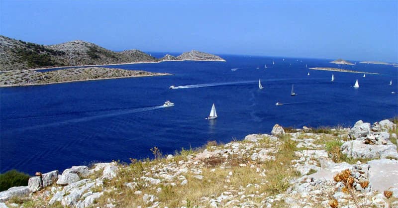
The Kornati landscape is defined by its karst-limestone terrain, a geological characteristic that shapes every aspect of the islands' appearance and ecology. The terrain displays remarkable diversity despite the relatively small area, ranging from dramatic sea cliffs that drop directly into the sea to extensive flat rock plateaus known locally as tarac. The porosity of karst rock means the islands drain rapidly, creating the characteristic dry, stony appearance that contrasts with the surrounding azure waters.

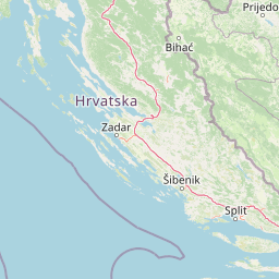
Geographically, the archipelago divides into two distinct sections. The Gornji Kornati (Upper Kornati) lie closer to the mainland and include the northernmost island of Sit and its surrounding islets, separated by a channel from Žut and its satellites to the south. Žut is the most indented and largest of the Upper Kornati. The Donji Kornati (Lower Kornati) extend toward the open sea in the southwest and include the major island of Kornat along with the surrounding islets that comprise most of the national park area.

The islands reach elevations of 237 meters at Klobuk on Kornat, though most of the terrain is relatively low and rolling. The coastline alternates between steep cliffs and small coves with beaches of round stones. Inland, the terrain is typically rocky with shallow soil accumulations in depressions. The flat rock areas (tarac) represent distinctive geological features where erosion has exposed smooth, level limestone surfaces. Numerous caves and sinkholes dot the landscape, typical of karst terrain everywhere in the Mediterranean region.

Kornati Islands National Park ecosystems, habitats, and plant life

The nature of Kornati reflects the harsh Mediterranean conditions that have shaped both flora and fauna on these limestone islands. Vegetation is sparse maquis shrubland, a reflection of the dry, stony terrain and the historical deforestation that removed the original Holm oak forests. Around 200 plant varieties have been documented on the islands, though many have degenerated from their historical abundance. The dominant vegetation consists of tough grasses and aromatic Mediterranean herbs including sage and feather grass, which bloom in spring and provide excellent forage for bees.

The marine environment surrounding the islands is protected as part of the national park, with fishing severely limited to allow regeneration of fish populations that were severely overfished in previous decades. The underwater relief creates a labyrinth of channels and varying depths that support distinctive marine communities. The waters are typical of the Adriatic and Mediterranean but contain some unique features due to the underwater topography, including particular assemblages of algae, coral, and sponges. The noble pen shell (Pinna nobilis), a large Mediterranean mollusk, lives in the Kornati waters and is protected by law.

The ecological significance extends to both land and sea, making this one of Croatia's more comprehensive protected areas. The limited human impact, with no permanent settlements within the park, has allowed ecosystems to maintain relatively natural character despite historical degradation. The protection of marine areas is particularly important in a region where coastal waters have faced significant fishing pressure.

Kornati Islands National Park wildlife and species highlights

Wildlife on the Kornati islands reflects the Mediterranean environment and the islands' relatively isolated position in the Adriatic Sea. The most numerous animals are seagulls, which nest on the coastal cliffs and are a constant presence throughout the archipelago. The terrestrial fauna is limited by the harsh conditions—dry terrain with sparse vegetation—but includes several reptile species including lizards and ring-snakes, as well as 69 documented butterfly varieties. Small populations of amphibians and rodents also inhabit the islands.

The marine wildlife is more varied and forms a significant part of the park's ecological significance. The waters support typical Adriatic and Mediterranean species, though the underwater relief creates conditions for some unique assemblages. The sea was historically one of the richest areas in the Adriatic for sponge hunters, though this population has declined with increased exploitation. The Mediterranean monk seal (Monachus albiventur) was once present around the islands, with the southernmost point Vela Kurka (Mendo) named in connection with this now nearly extinct species.

The protection of marine areas within the national park has been crucial for allowing fish populations to regenerate after decades of overfishing. This comprehensive approach to protecting both land and sea ecosystems distinguishes Kornati and reflects a more holistic understanding of ecological conservation in coastal environments.

Kornati Islands National Park conservation status and protection priorities

Kornati Islands National Park represents a comprehensive approach to conservation that protects both terrestrial and marine environments—a distinction that sets it apart from many other protected areas in the region. The 1980 designation created protections for 89 southern islands of the archipelago, encompassing approximately 320 square kilometers of combined sea and land area. Within this area, 109 islands, islets, and reefs fall under national park jurisdiction.

The conservation framework recognizes the interconnectedness of land and sea ecosystems in this Mediterranean archipelago. Fishing within park boundaries is extremely limited to allow regeneration of fish shoals that had been severely depleted by decades of intensive exploitation. The protection of the marine environment is particularly significant in the Adriatic Sea, where coastal fisheries have faced considerable pressure.

Specific species receive additional legal protection, most notably the noble pen shell (Pinna nobilis), a large Mediterranean bivalve that inhabits the waters around the islands. The Mediterranean monk seal, though now nearly extinct from the region, is recognized historically as part of the islands' biodiversity heritage. The karst geology and its embedded fossil record also represent a form of geological conservation protected within the park boundaries.

The park management works from Murter, the neighboring island connected to the mainland, coordinating efforts to preserve this unique Mediterranean ecosystem while acknowledging the islands' long human history and cultural heritage.

Kornati Islands National Park cultural meaning and human context

The Kornati islands carry a rich human heritage that spans several millennia, though no permanent settlements exist within the national park today. Archaeological evidence documents continuous human presence from the Neolithic Age through the Illyrian and Roman periods, with the Venetian era leaving particularly visible marks on the landscape. On Kornat island, the small tower known as Toreta likely dates to the 6th century AD, representing Byzantine or early medieval construction.

Roman presence is especially well-documented, with mosaic floors from villas still visible and evidence of active stone quarries at locations including Stražišče, Tarac, Levrnaka, and Lavsa. The Middle Ages saw the island of Piškera used as a storage point for fish, indicating the continuity of maritime economic activity that characterizes the Dalmatian coast.

During Venetian rule, the islands served strategic purposes for the fleet, contributing to the deforestation and overgrazing that transformed the landscape from its original forested state to the sparse maquis that dominates today. In the late 19th century, islands were purchased by mainland landowners from Murter and Dugi Otok, who maintain seasonal shelters in protected coves but do not maintain permanent residences.

The archipelago is sometimes known as the Stomorski islands, reflecting historical administrative divisions. Some island names, like Babina Guzica and Kurba Vela, originated as mock vulgar names given to Austrian surveyors by local guides at the end of the 19th century, demonstrating the islands' distinctive naming traditions.

Top sights and standout views in Kornati Islands National Park

Kornati Islands National Park offers one of the Mediterranean region's most distinctive island wilderness experiences through its exceptional concentration of islands within a relatively small area. The karst limestone landscape creates dramatic visual contrasts between rugged cliffs, flat rock plateaus, and the vivid blue Adriatic waters. The complete protection of both land and sea provides rare opportunities to experience Mediterranean ecosystems with minimal human development—indeed, there are no permanent settlements within the park boundaries. The islands' archaeological heritage spans from Neolithic settlements through Roman villas and medieval towers, adding historical depth to the natural landscape. The marine protection has allowed fish populations to regenerate in waters that were once severely overfished, creating improved opportunities for observing marine life. The density of the archipelago—unmatched anywhere in the Mediterranean—creates a unique navigational and visual experience for visitors exploring by boat.

Best time to visit Kornati Islands National Park

The Kornati islands can be visited year-round, though the peak season corresponds with the broader Mediterranean tourism period from May through September. Summer months offer the warmest conditions with sea temperatures reaching 22-23°C, making swimming and water activities appealing. However, the peak summer period also brings the largest numbers of visitors to the archipelago.

Spring and autumn offer more moderate conditions with fewer crowds while maintaining comfortable temperatures for outdoor exploration. The average July temperature of 23.9°C provides pleasant conditions for hiking and island exploration, while the mild winter with January averages around 7°C allows for quieter visits, though many services are reduced during the off-season.

The climate supports year-round accessibility for those seeking solitude, though the summer fire risk—most notably the tragic 2007 fire that claimed twelve firefighters' lives—creates periods when access restrictions may be in place. The spring bloom brings the aromatic maquis vegetation into flower, creating particularly fragrant conditions across the islands. Sea conditions are generally calm during the summer months, making boat navigation among the islands safer and more pleasant.

Park location guide

Geography guide, regional context, and park location map for Kornati Islands National Park

Kornati Islands National Park park geography, regions, and map view in Croatia
Understand where Kornati Islands National Park sits in Croatia through a broader geographic reading of the surrounding landscape, nearby location context, and its mapped position within the national park landscape.

How Kornati Islands National Park fits into Croatia

Croatia is a unitary parliamentary republic located in Central and Southeast Europe along the Adriatic Sea. With an area of approximately 56,600 km² and a population of nearly 3.9 million, it is a member of the European Union and uses the Euro as its currency. Zagreb serves as both the capital and largest city.

Wider geography shaping Kornati Islands National Park in Croatia

Croatia is located in Central and Southeast Europe, bordering Slovenia and Hungary to the northwest and northeast respectively, Serbia to the east, Bosnia and Herzegovina and Montenegro to the southeast, with a maritime border with Italy to the west. The country occupies the eastern shores of the Adriatic Sea and spans the Dinaric Alps, Pannonian plain, and coastal islands.

Map view of Kornati Islands National Park

Use this park location map to pinpoint Kornati Islands National Park in Croatia, understand its exact geographic position, and read its mapped placement within the surrounding landscape more clearly.

Pigeon | © OpenStreetMap contributors

Location context for Kornati Islands National Park

Šibenik-Knin County

Explore the dramatic cliffs, unique rock formations, and diverse marine environments that define this Croatian protected area.

Kornati Islands National Park Photos: Visualizing the Archipelago's Karst Landscapes
Browse a curated collection of photography showcasing the dramatic karst-limestone terrain and the rugged beauty of Kornati Islands National Park. This visual reference helps you understand the ecological and geological distinctiveness of this Mediterranean archipelago, from towering sea cliffs to extensive flat rock surfaces.

Rocky shoreline with dry grass, blue sea, multiple sailboats, and distant islands under clear blue sky

Two men handling fishing nets on a dock near boats and rocky coastline

Park atlas

Browse the Diverse Karst Landscapes and Marine Protected Areas of Croatia's Dalmatian Coast and Adriatic Archipelago

Compare Other National Parks and Protected Areas Near Kornati Islands National Park
After exploring Kornati Islands National Park, trace other protected areas across Croatia's Dalmatian coastline and its dense Mediterranean archipelago. This geographic context allows for detailed comparison of diverse karst landscapes, unique marine environments, and other national park formations within the broader Adriatic region.
National parkŠibenik-Knin County

Krka National Park: Croatia's National Park with European Cascade Waterfalls

Explore the mapped protected landscape and karst geography.

Krka National Park, designated as a national park in Croatia, offers a rich exploration of its protected landscape. Located in Šibenik-Knin County, the park is defined by the Krka River and its extraordinary seven travertine waterfalls, most notably Skradinski buk, the largest cascade system of its kind in Europe. This atlas-focused view highlights the park's unique karst terrain, Mediterranean ecosystems, and its position within the regional geography, providing essential context for understanding its protected natural heritage.

Area
109 km²
Established
1985
Relief
Lowland
Climate
Mediterranean
National park

Paklenica National Park: Croatia's Iconic Karst Canyon and UNESCO Beech Forests

Explore dramatic protected landscape and regional geography.

Paklenica National Park presents a spectacular protected area defined by its deep karst canyons, with Velika Paklenica and Mala Paklenica carving dramatic vertical walls into the Velebit mountain range. This national park is celebrated for its status as a leading European climbing destination and its ancient beech forests, part of a UNESCO World Heritage site. Exploring Paklenica offers insight into unique geological formations, extensive cave systems, and the rich biodiversity of this significant Croatian landscape.

Area
95 km²
Relief
Mountain
Climate
Mediterranean
Access
Moderate access
National park

Una National Park: Bosnia and Herzegovina's Largest National Park and Protected Landscape

Explore its dramatic river canyons and karst geography.

Una National Park represents a significant protected landscape in Bosnia and Herzegovina, covering approximately 198 square kilometers of the Upper Una River basin. This page details the park's protected area identity, focusing on its spectacular riverine geography, including iconic features like the Štrbački Buk waterfall and the deep Unac River canyon. Users can explore the park's mapped boundaries, understand its place within the regional Dinaric mountain context, and discover the characteristics of its unique karst terrain and pristine river ecosystems. MoriAtlas provides essential geographic context for this vital natural area.

Area
350 km²
Established
2008
IUCN
II
Relief
Mixed relief
National park

Northern Velebit National Park: Croatia's Mapped Protected Landscape Identity

Explore the geography and protected area context.

Northern Velebit National Park stands as a prominent protected area, contributing significantly to the geographic understanding of Croatia's Velebit mountain range. This page provides focused details on its protected landscape features, mapped boundaries, and position within the Dinaric Alps. It serves as an essential entry point for users seeking structured atlas-based information on national parks and their role in regional conservation efforts, highlighting its unique geographic characteristics.

National park

Plitvice Lakes National Park: Croatia's Iconic National Park and UNESCO Heritage Site

Mapped protected area with cascading lakes and karst geography.

Delve into the protected landscape of Plitvice Lakes National Park, a jewel of Croatia's natural heritage. This atlas entry highlights the park's famous system of 16 terraced lakes and cascading waterfalls, set within a unique karst terrain. Understand the geographic context and mapped boundaries of this significant protected area, renowned for its geological processes and ancient forest ecosystems. Explore the full spectrum of its protected natural identity.

Watercolor illustration of a landscape with green hills, a river, and distant mountains under a light sky
Protected landscapeDalmatia

Biokovo Nature Park: Protected Landscape and Karst Terrain in Dalmatia

Explore Dalmatia's premier protected mountain range along the Adriatic.

Biokovo Nature Park is a striking protected landscape situated in the Dalmatia region of Croatia, characterized by its immense limestone massifs that create a formidable barrier between the coast and the continental interior. This protected area is defined by its classic karst topography, featuring a complex network of sinkholes and caves, and offers unparalleled views from peaks like Sveti Jure. MoriAtlas provides detailed geographic context for understanding Biokovo Nature Park's unique terrain, mapped boundaries, and its significant role in the regional landscape.

Area
196 km²
Established
1981
Relief
Mountain
Climate
Mediterranean
Watercolor illustration of rolling hills, green vegetation, and distant mountains under a light sky
Protected area

Lastovo Nature Park: Discover the Adriatic Karst Archipelago's Protected Landscape

Mapped karst terrain, ancient architecture, and natural island geography.

Lastovo Nature Park protects a remote Croatian archipelago characterized by its striking karst landscape, featuring 46 hills and 46 karstic fields. This protected area offers significant natural biodiversity and remarkably preserved cultural heritage, with extensive Holm Oak and Aleppo Pine forests covering over 60% of the island. Explore Lastovo's unique geography, mapped terrain, and its distinct place within the Adriatic region.

Area
46.87 km²
Established
2006
Relief
Upland
Climate
Mediterranean
Watercolor painting of coastal landscape with green islands, trees, and calm water under a soft sky
National park

Brijuni Islands National Park: Adriatic Protected Landscape and Historical Atlas

Mapped boundaries, regional geography, and ecological context.

Brijuni Islands National Park is a significant protected area comprising a Croatian archipelago in the northern Adriatic Sea. This national park showcases a unique Mediterranean landscape blending natural habitats with extensive archaeological sites, offering a rich context for atlas-based exploration. Understanding Brijuni Islands National Park contributes to a broader appreciation of regional geography and the mapped distribution of protected lands.

Area
7.5 km²
Established
1983
Relief
Lowland
Climate
Mediterranean

Common questions about visiting, size, designation, and location context for Kornati Islands National Park

Kornati Islands National Park FAQs for park facts, access, geography, and protected area context
Find quick answers about Kornati Islands National Park, including protected-area facts, park geography, trail and visitor context, and how the park fits into its surrounding country and regional landscape.
MoriAtlas Explorer

Continue Your Protected Areas Search Across the Global Atlas

Deepen your exploration by continuing the structured search for national parks and protected areas worldwide. Utilize the comprehensive filtering capabilities to compare different conservation landscapes and refine your understanding of global park geography. Discover more about the distribution and characteristics of protected natural areas.

Global natural geography