Mori Atlas logo
National parkPaklenica National Park

Discover dramatic vertical limestone cliffs, ancient beech forests, and extensive cave systems.

Paklenica National Park: Croatia's Premier Karst Canyon National Park on Velebit Mountain

(Nacionalni park Paklenica)

Paklenica National Park stands as a significant protected landscape within Croatia's Velebit mountain range, renowned for its breathtaking karst canyons, particularly Velika and Mala Paklenica. This national park offers a unique exploration of dramatic vertical limestone walls, ancient beech forests recognized by UNESCO, and a complex network of cave systems. Its designation as a premier climbing destination and its position within the rugged Dalmatian geography provide rich context for map-based discovery and understanding protected natural areas.

Karst landscapeCanyonRock climbingUNESCO World HeritageBeech forestDalmatia

Paklenica National Park

National park

Park overview

Structured park overview, official facts, and landscape profile for Paklenica National Park

Paklenica National Park park facts, protected area profile, and essential visitor context
Review the core facts for Paklenica National Park, including designation, size, terrain, visitor scale, habitats, and operating context in one park-focused overview.

About Paklenica National Park

Paklenica National Park protects a singularly impressive landscape where the Velebit mountain range descends sharply toward the Adriatic Sea, creating a complex of deep canyons, dramatic cliffs, and forested slopes that stands as one of Croatia's most significant natural areas. The park's two main canyons—Velika Paklenica and Mala Paklenica—have been carved over millennia by the waters that once flowed through this karst terrain, leaving behind a labyrinth of vertical limestone walls, rocky gorges, and hidden caves that define the character of the landscape. The Velika Paklenica canyon reaches 14 kilometers in length and varies from 500 to 800 meters in width, narrowing to just 50 meters at the section called the Bunkers, where sheer cliffs rise on both sides to heights exceeding 700 meters. This dramatic topography has made the canyon a legendary destination for rock climbers, who have developed hundreds of routes on its walls since the 1950s, establishing Paklenica as the premier climbing area in Croatia and Southeast Europe. Beyond the climbing walls, the park encompasses a diverse array of habitats including steep forested slopes, karst plateaus, alpine meadows, and the cave systems that penetrate the mountain. The forests of Paklenica are particularly noteworthy—approximately 55 percent of the park is covered in vegetation, with beech forests dominating at 52 percent, black pine at 20 percent, and mixed forests comprising another 8 percent. In 2017, significant portions of these beech forests were inscribed on the UNESCO World Heritage List as part of a transcontinental effort to protect the remnants of Europe's ancient forests. The park's elevation gradient—from sea level at the canyon entrances to peaks exceeding 1,750 meters—creates remarkable ecological diversity, supporting species ranging from Mediterranean plants at lower elevations to alpine species on the highest ridges.

Quick facts and research context for Paklenica National Park

Paklenica covers 95 square kilometers along the Velebit mountain range near the coastal town of Starigrad, approximately 30 kilometers northeast of Zadar. The park's dramatic topography features canyons that narrow to just 50 meters at their tightest points, with surrounding cliffs reaching heights exceeding 700 meters. The highest peaks within the park are Vaganski vrh at 1,757 meters and Sveto brdo at 1,753 meters. The area's karst geology has produced an extensive cave system, including Vodarica pit—the longest cave in Velebit at 300 meters—and Precipice on Bunovac, which at 534 meters is the deepest pit in central and south Velebit. The park contains approximately 150 to 200 kilometers of marked hiking trails and serves as the most visited climbing site in Croatia and all of Southeast Europe.

Park context

Deeper park guide and search-rich context for Paklenica National Park

Paklenica National Park history, landscape, wildlife, and travel context
Explore Paklenica National Park through its history, landscape character, ecosystems, wildlife, conservation priorities, cultural context, and seasonal travel timing in a structured park guide built for atlas discovery and search intent.

Why Paklenica National Park stands out

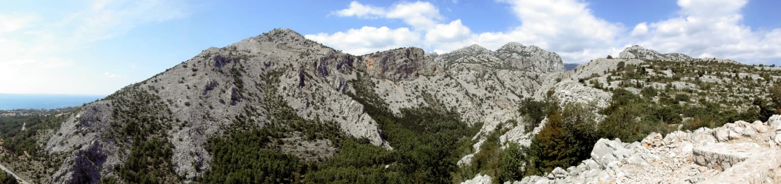
Paklenica is best known for its spectacular vertical limestone walls in the Velika Paklenica canyon, which feature over 360 rock climbing routes of varying difficulty. The iconic Anića kuk pinnacle, rising 712 meters above the canyon floor, hosts some of the most challenging big-wall routes in the region and has been a legendary destination for climbers since the sport resumed in 1955. The park's dramatic karst canyon scenery, with its towering cliffs and narrow passages, represents one of the most impressivemountain landscapes along the entire Adriatic coast. Additionally, the ancient beech forests of southern Velebit, inscribed on the UNESCO World Heritage List as part of the Ancient and Primeval Beech Forests of the Carpathians and Other Regions of Europe, distinguish Paklenica as a site of outstanding universal value for European forest ecology.

Paklenica National Park history and protected-area timeline

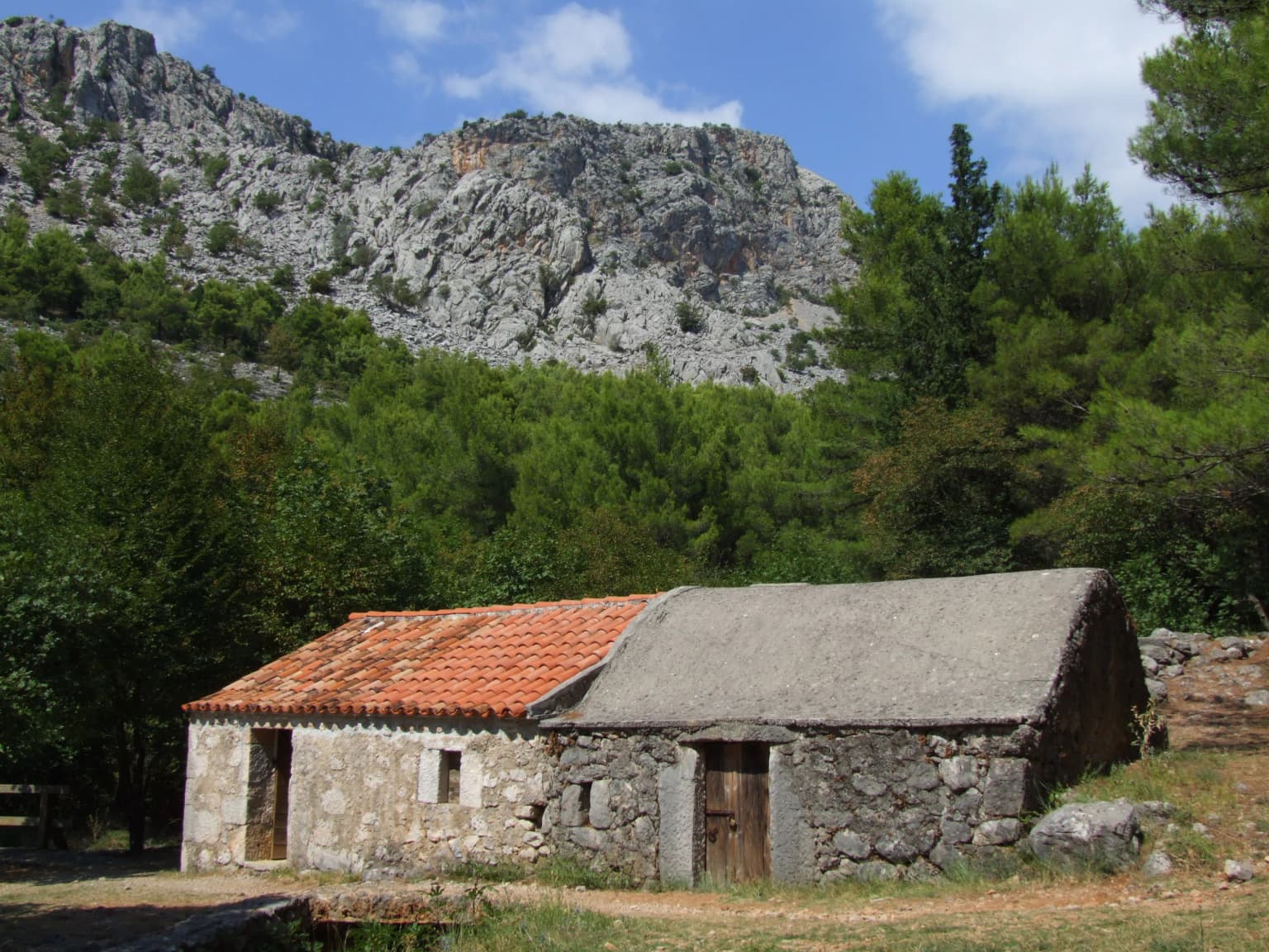
The Paklenica region has been inhabited since prehistoric times, with Mesolithic flint tools found in Vaganačka Cave beneath Veliko Rujno providing evidence of human presence during the last ice age, when sea levels were 120 meters lower than today and the Velebit Channel was a broad river valley. Approximately eight thousand years ago, the first cattle breeders and farmers arrived, bringing domestic goats, sheep, and wheat, marking a transition from hunter-gatherer lifestyles to livestock-rearing that would define the region's economy for millennia. During the Bronze Age, Liburnian peoples constructed fortified settlements and stone buildings—some serving as refuges for surrounding villages, others as seats of local rulers—overseeing important trade and cattle routes through the Paklenica corridor. The Roman period saw the establishment of Starigrad (ancient Argyruntum) as a significant trading center on the Adriatic coast, with Emperor Tiberius fortifying the town in the 4th century AD. Archaeological excavations have yielded over 400 graves containing jewelry, glassware, weapons, and tools, including a remarkable collection of 146 ancient glass vessels. Following the Roman period, the area saw Justinian-era fortifications built to defend against invading tribal peoples. The arrival of Croats in the early Middle Ages brought the construction of chapels including St. George in Rovanjska, St. Peter in Starigrad, and St. Mary Magdalene, as well as medieval forts such as Večka Kula and Paklarić. The modern era brought dramatic developments during the Yugoslav period, when an underground military complex was constructed between 1950 and 1953 at the height of Cold War tensions—a facility that remained classified until 1991 and now serves as a visitor center dedicated to mountain climbing. Rock climbing in Paklenica resumed in 1955 and has since developed into the primary attraction, with the park hosting the first Yugoslav alpine climbing gathering in 1959 and establishing itself as a cradle of Croatian and Yugoslav alpinism.

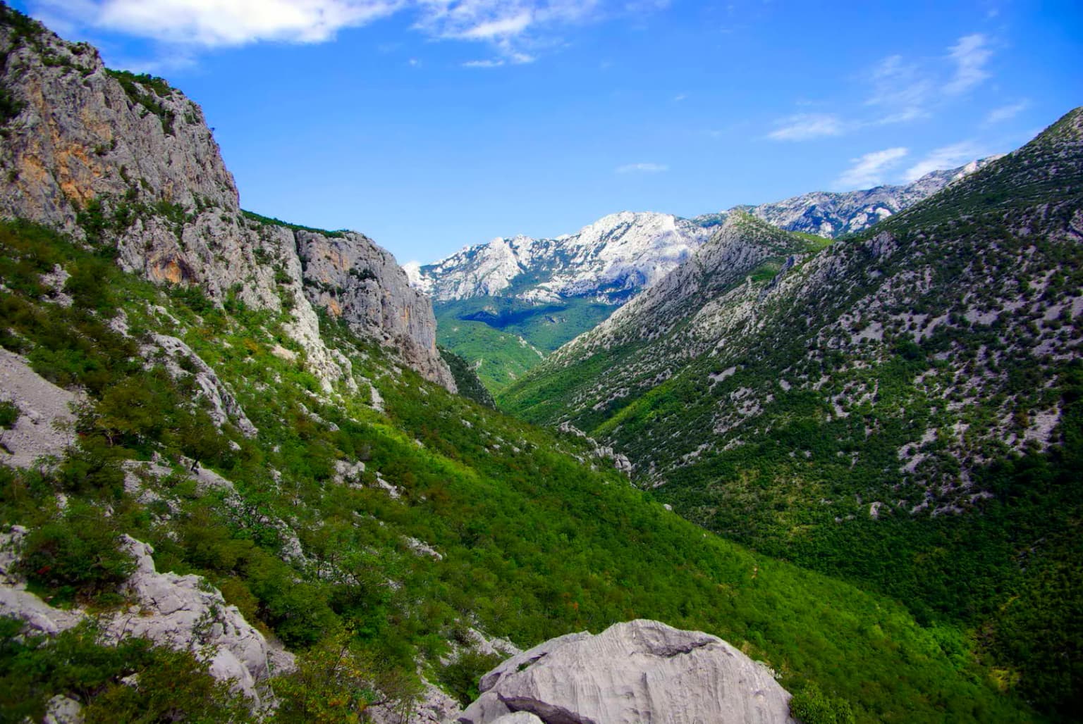
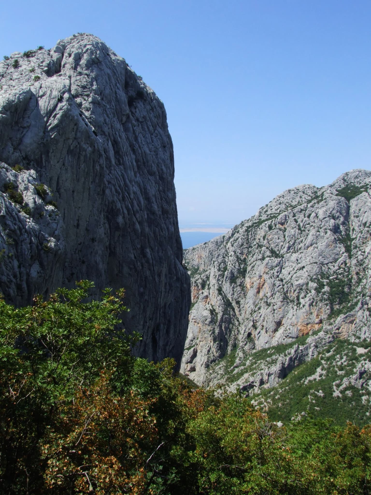
Paklenica National Park landscape and geographic character

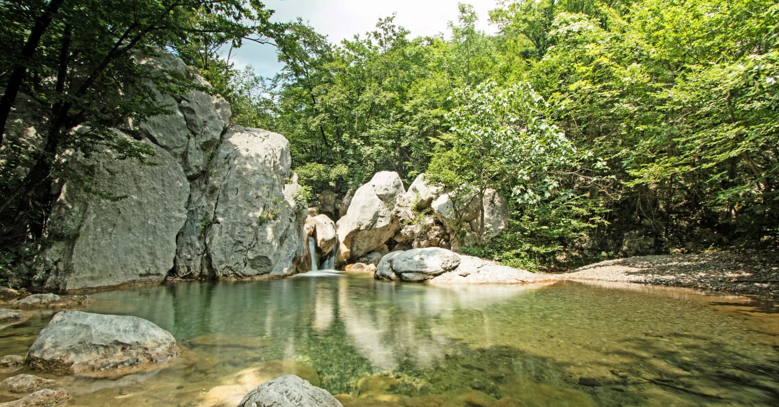
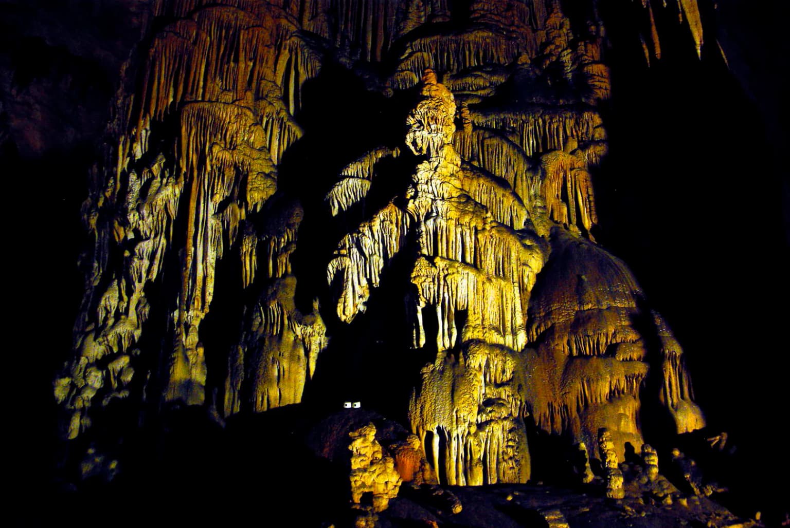
The physical landscape of Paklenica is defined by its two spectacular karst canyons, which have been carved by water through thousands of years of geological time. Velika Paklenica, the larger and more dramatic of the two, extends 14 kilometers into the Velebit mountains, with walls rising 500 to 800 meters above the canyon floor and narrowing to just 50 meters at its most dramatic constriction near the Bunkers. The most impressive section occurs downstream from Anića luka, where vertical cliffs rise directly beside the stream, creating a tunnel-like passage of extraordinary beauty. Mala Paklenica, though smaller at 12 kilometers in length and 400 to 500 meters in width, presents similarly dramatic scenery with cliffs reaching 650 meters and a narrow channel at one point only 10 meters wide. The central area of the park features the Borovnik and Crni vrh relief complex, with the distinctive bowl-shaped valley of Velika Močila sitting at 850 meters above sea level, surrounded by peaks including Crni vrh at 1,110 meters. The eastern portion of the park is geomorphologically diverse, inaccessible, and wild, transitioning into milder karst plateaus around Malo Libinje and Veliko Libinje with numerous pits and karst depressions. The highest terrain occupies a narrow ridge of Velebit, 1 to 3 kilometers wide, with Vaganski vrh—the highest peak of Velebit—rising to 1,757 meters. The park's karst geology has produced an extensive subterranean landscape, with 76 documented speleological objects including 39 pits and 37 caves, making it one of the most thoroughly explored speleological areas in Croatia.

Paklenica National Park ecosystems, habitats, and plant life

The ecological character of Paklenica reflects the complex interaction between its karst terrain, elevation range, and position at the junction of Mediterranean and continental climate influences. The park contains approximately 1,000 plant species and subspecies, of which 79 are endemic—representing a remarkable concentration of botanical diversity for this relatively small area. The vegetation is organized in distinct zones that follow elevation and exposure: oak and oriental hornbeam forests occupy the lower slopes, giving way to extensive beech forests that form the dominant forest type at middle elevations, while black pine forests occur on drier sites and the mountain pine (Pinus mugo) marks the upper forest limit. Fern forests develop in the cooler, more humid microclimates of the canyon floors. The ancient beech forests within the park were recognized in 2017 as part of the UNESCO World Heritage inscription covering ancient and primeval beech forests across Europe, acknowledging their significance as living records of forest ecological dynamics since the last Ice Age. The park's position on the Velebit mountain—essentially a land bridge between the continental interior and the Adriatic coast—creates a meeting point for species from different biogeographic origins, enhancing the overall biodiversity. Approximately 55 percent of the park is covered in vegetation, while the remaining 45 percent consists of bare karst rock, creating a mosaic of forested slopes and exposed limestone that characterizes the visual identity of southern Velebit.

Paklenica National Park wildlife and species highlights

Paklenica supports a rich vertebrate fauna that reflects the diversity of its habitats and the ecological importance of the Velebit corridor as a migration route and biogeographic crossroads. Birds represent the most diverse vertebrate group, with 230 species recorded to date, including 102 species that nest within the broader park area. The canyon cliffs of Velika and Mala Paklenica host a community of 24 bird species specialized for rock and cliff habitats, while the endangered golden eagle, peregrine falcon, short-toed eagle, and northern goshawk add particular conservation significance to the avifauna. Forest areas support populations of woodpeckers, including the rare white-backed woodpecker and middle spotted woodpecker. The park is home to 53 mammal species, with roe deer and chamois being characteristic large mammals of the mountainous terrain, while the brown bear represents the apex predator. Over 40 species of amphibians and reptiles are found within the park, including the endangered Orsini's viper—a species of particular conservation concern. The cave systems support an interesting community of subterranean species including crabs, mites, nematodes, aquatic worms, spiders, pseudoscorpions, beetles, and bats, representing a specialized underground fauna adapted to the dark, stable conditions of the karst environment.

Paklenica National Park conservation status and protection priorities

Paklenica holds significant conservation value at multiple levels, from national importance to outstanding universal significance at the global scale. The park was established in 1949 as the second-oldest national park in Croatia, following only Plitvice Lakes, and represents a long-standing commitment to protecting the natural heritage of the Velebit region. The inclusion of the park's ancient beech forests in the UNESCO World Heritage inscription of the Ancient and Primeval Beech Forests of the Carpathians and Other Regions of Europe in 2017 marked a pivotal moment, recognizing these forests as representing outstanding examples of forest ecological processes in Europe since the last Ice Age. The 2,031 hectares of old-growth beech forest within the park at locations called Suva draga–Klimenta and Oglavinovac–Javornik form part of a trans-European World Heritage site spanning 18 countries. The park's conservation significance extends beyond its forests to include its karst landscape—which represents one of the most completely explored speleological areas in Croatia—the diversity of endemic species, and the populations of threatened birds including golden eagles and peregrine falcons. The presence of Orsini's viper, an endangered species of European conservation concern, further underscores the park's importance for reptile conservation.

Paklenica National Park cultural meaning and human context

The Paklenica landscape bears the imprint of human presence spanning thousands of years, from prehistoric hunters through the Bronze Age Liburnian civilizations, Roman settlers, medieval communities, and the modern era. The Liburnian peoples, who inhabited the eastern Adriatic coast during the last two thousand years BC, constructed fortified stone settlements—some serving as refuges, others as seats of local rulers—along the Paklenica corridor, overseeing important cattle and trade routes leading to Lika via the mountain passes. Ring-shaped burial mounds called gromile, and casket heaps where rulers were buried in stone-tablet coffins, represent the physical traces of this ancient civilization. The Roman period saw Starigrad established as Argyruntum, a trading center whose ruins and cemetery have yielded extensive archaeological material, including a remarkable collection of 146 ancient glass vessels now housed in the Zadar Museum of Archaeology. Medieval Christian heritage survives in the form of chapels including St. George in Rovanjska, St. Peter in Starigrad, and St. Mary Magdalene, built between the 9th and 12th centuries. The Cold War-era underground military complex, constructed between 1950 and 1953 and only declassified in 1991, represents a more recent layer of human history—now repurposed as a visitor center that connects the park's natural landscape with its climbing heritage.

Top sights and standout views in Paklenica National Park

Paklenica combines extraordinary natural beauty with remarkable biodiversity and outstanding recreational opportunities in a setting that is uniquely Croatian. The dramatic vertical cliffs of the Velika Paklenica canyon, particularly the Anića kuk pinnacle, represent one of the finest climbing destinations in Europe, with routes ranging from beginner-friendly paths to some of the most challenging big-wall ascents on the continent. The ancient beech forests—inscribed on the UNESCO World Heritage List—provide a rare glimpse of Europe's primeval forest heritage, with trees that have grown for centuries in a landscape largely untouched by modern forestry. The park's 76 documented caves and pits make it a paradise for speleologists, while the network of 150 to 200 kilometers of marked trails offers exceptional hiking through terrain that ranges from Mediterranean canyon floors to alpine peaks exceeding 1,750 meters. The presence of brown bears, chamois, golden eagles, and over 230 bird species makes Paklenica a outstanding destination for wildlife observation, while the karst landscape itself—with its sinkholes, caves, and sculpted limestone—represents a geological masterpiece that has been shaped over millions of years.

Best time to visit Paklenica National Park

Paklenica can be visited throughout the year, though the optimal seasons for different activities vary considerably. For rock climbing, the main season begins in spring and extends through late autumn, with comfortable temperatures and conditions suitable for extended climbs on the limestone walls. The shoulder seasons of April through June and September through October offer the most pleasant hiking conditions, with moderate temperatures in the canyons and wildflowers in spring or golden foliage in autumn adding to the visual appeal. Summer months can be very hot in the canyon bottoms, though the higher elevations and forest trails provide cooler alternatives. Winter brings snow to the upper elevations and can render some trails impassable, but offers a dramatically different character for those interested in experiencing the park in solitude. The park remains open year-round, though some facilities and trails may have seasonal access restrictions.

Park location guide

Geography guide, regional context, and park location map for Paklenica National Park

Paklenica National Park park geography, regions, and map view in Croatia
Understand where Paklenica National Park sits in Croatia through a broader geographic reading of the surrounding landscape, nearby location context, and its mapped position within the national park landscape.

How Paklenica National Park fits into Croatia

Croatia is a unitary parliamentary republic located in Central and Southeast Europe along the Adriatic Sea. With an area of approximately 56,600 km² and a population of nearly 3.9 million, it is a member of the European Union and uses the Euro as its currency. Zagreb serves as both the capital and largest city.

Wider geography shaping Paklenica National Park in Croatia

Croatia is located in Central and Southeast Europe, bordering Slovenia and Hungary to the northwest and northeast respectively, Serbia to the east, Bosnia and Herzegovina and Montenegro to the southeast, with a maritime border with Italy to the west. The country occupies the eastern shores of the Adriatic Sea and spans the Dinaric Alps, Pannonian plain, and coastal islands.

Map view of Paklenica National Park

Use this park location map to pinpoint Paklenica National Park in Croatia, understand its exact geographic position, and read its mapped placement within the surrounding landscape more clearly.

Pigeon | © OpenStreetMap contributors

Location context for Paklenica National Park

Zadar County
Park atlas

Map adjacent protected landscapes, regional park geography, and diverse conservation areas.

Compare Related National Parks and Protected Areas Beyond Paklenica National Park
After exploring Paklenica National Park's dramatic karst canyons and ancient beech forests, browse other national parks and protected areas across Croatia's diverse landscapes. Trace mapped park geography, compare regional protected zones, and discover connected conservation areas to expand your understanding of the Adriatic region.
National park

Northern Velebit National Park: Croatia's Mapped Protected Landscape Identity

Explore the geography and protected area context.

Northern Velebit National Park stands as a prominent protected area, contributing significantly to the geographic understanding of Croatia's Velebit mountain range. This page provides focused details on its protected landscape features, mapped boundaries, and position within the Dinaric Alps. It serves as an essential entry point for users seeking structured atlas-based information on national parks and their role in regional conservation efforts, highlighting its unique geographic characteristics.

National park

Una National Park: Bosnia and Herzegovina's Largest National Park and Protected Landscape

Explore its dramatic river canyons and karst geography.

Una National Park represents a significant protected landscape in Bosnia and Herzegovina, covering approximately 198 square kilometers of the Upper Una River basin. This page details the park's protected area identity, focusing on its spectacular riverine geography, including iconic features like the Štrbački Buk waterfall and the deep Unac River canyon. Users can explore the park's mapped boundaries, understand its place within the regional Dinaric mountain context, and discover the characteristics of its unique karst terrain and pristine river ecosystems. MoriAtlas provides essential geographic context for this vital natural area.

Area
350 km²
Established
2008
IUCN
II
Relief
Mixed relief
National park

Plitvice Lakes National Park: Croatia's Iconic National Park and UNESCO Heritage Site

Mapped protected area with cascading lakes and karst geography.

Delve into the protected landscape of Plitvice Lakes National Park, a jewel of Croatia's natural heritage. This atlas entry highlights the park's famous system of 16 terraced lakes and cascading waterfalls, set within a unique karst terrain. Understand the geographic context and mapped boundaries of this significant protected area, renowned for its geological processes and ancient forest ecosystems. Explore the full spectrum of its protected natural identity.

National parkŠibenik-Knin County

Kornati Islands National Park: Dense Mediterranean Archipelago and Protected Karst Landscape

Explore the mapped geography and unique protected island terrain.

Kornati Islands National Park, located in Šibenik-Knin County, Croatia, is distinguished as the Mediterranean's most densely packed archipelago. This national park protects a vast expanse of karst limestone islands, dramatic sea cliffs, and unique flat rock plateaus, alongside its significant marine environment. MoriAtlas provides detailed geographic context and mapped boundaries, enabling structured exploration of this exceptional protected landscape and its ecological significance within the Adriatic Sea.

Area
320 km²
Established
1980
Relief
Lowland
Climate
Mediterranean
National parkŠibenik-Knin County

Krka National Park: Croatia's National Park with European Cascade Waterfalls

Explore the mapped protected landscape and karst geography.

Krka National Park, designated as a national park in Croatia, offers a rich exploration of its protected landscape. Located in Šibenik-Knin County, the park is defined by the Krka River and its extraordinary seven travertine waterfalls, most notably Skradinski buk, the largest cascade system of its kind in Europe. This atlas-focused view highlights the park's unique karst terrain, Mediterranean ecosystems, and its position within the regional geography, providing essential context for understanding its protected natural heritage.

Area
109 km²
Established
1985
Relief
Lowland
Climate
Mediterranean
Watercolor illustration of a mountainous landscape with green forests, a lake, and distant pink-hued mountains under a light sky
National parkPrimorje-Gorski Kotar County

Risnjak National Park: Protected Mountain Landscape in Primorje-Gorski Kotar

Explore karst terrain and regional geographic context.

Risnjak National Park represents a substantial protected area within the rugged mountain geography of Croatia's Gorski Kotar region. This national park is distinguished by its dramatic karst formations, diverse alpine flora reaching from forested slopes to rocky summits, and the significant natural landmark of the Kupa River's source. Discover its mapped boundaries and the ecological importance of this unique landscape situated in Primorje-Gorski Kotar County.

Area
63.5 km²
Established
1949
Visitors
16.8K annual
Relief
Mountain
National park

Kozara National Park: Bosnia and Herzegovina's Distinctive Forested Mountain Landscape

Mapped protected area in the Pannonian Plain's highland oasis.

Kozara National Park represents a significant protected natural area within Bosnia and Herzegovina, distinguished by its rounded, forested peaks that ascend from the surrounding Pannonian lowlands. This national park offers a unique landscape characterized by dense deciduous and mixed forests, interspersed with clearings and meadows, covering a considerable portion of its 39 square kilometer area. The park's geographic identity is further defined by its proximity to major rivers like the Una, Sava, Sana, and Vrbas, which delineate its natural boundaries and contribute to its distinct regional context. For atlas-based discovery, Kozara provides insight into how isolated highlands create unique protected landscapes within flatter terrain.

Area
39.08 km²
Established
1967
IUCN
II
Relief
Upland
Watercolor painting of coastal landscape with green islands, trees, and calm water under a soft sky
National park

Brijuni Islands National Park: Adriatic Protected Landscape and Historical Atlas

Mapped boundaries, regional geography, and ecological context.

Brijuni Islands National Park is a significant protected area comprising a Croatian archipelago in the northern Adriatic Sea. This national park showcases a unique Mediterranean landscape blending natural habitats with extensive archaeological sites, offering a rich context for atlas-based exploration. Understanding Brijuni Islands National Park contributes to a broader appreciation of regional geography and the mapped distribution of protected lands.

Area
7.5 km²
Established
1983
Relief
Lowland
Climate
Mediterranean

Common questions about visiting, size, designation, and location context for Paklenica National Park

Paklenica National Park FAQs for park facts, access, geography, and protected area context
Find quick answers about Paklenica National Park, including protected-area facts, park geography, trail and visitor context, and how the park fits into its surrounding country and regional landscape.
MoriAtlas Explorer

Continue Your Protected Areas Search Across the Global Atlas

Deepen your exploration by continuing the structured search for national parks and protected areas worldwide. Utilize the comprehensive filtering capabilities to compare different conservation landscapes and refine your understanding of global park geography. Discover more about the distribution and characteristics of protected natural areas.

Global natural geography