Mori Atlas logo
National parkKozara National Park

Discover mapped boundaries and regional geography of this distinct highland oasis.

Kozara National Park: Bosnia and Herzegovina's Protected Forested Mountain Landscape

Kozara National Park stands as a vital protected national park in northwestern Bosnia and Herzegovina, notable for its distinctive forested mountain terrain rising from the surrounding Pannonian Plain. Established in 1967, this approximately 39 square kilometer highland preserve showcases rounded peaks reaching up to 876 meters. Its location near the confluence of the Una, Sava, Sana, and Vrbas rivers creates a natural geographic boundary, making it a unique mapped landscape for atlas exploration and discovery of its protected area identity.

National ParkForested MountainsWWII MemorialBosnia and HerzegovinaRepublika SrpskaHiking Trails

Kozara National Park

National park

Park overview

Structured park overview, official facts, and landscape profile for Kozara National Park

Kozara National Park park facts, protected area profile, and essential visitor context
Review the core facts for Kozara National Park, including designation, size, terrain, visitor scale, habitats, and operating context in one park-focused overview.

About Kozara National Park

Kozara National Park occupies a distinctive geographic position in the Dinaric mountain system of the Balkans, rising as an isolated forested mountain mass from the flatlands of the Sava River basin in northwestern Bosnia and Herzegovina. The park was officially established in 1967 as a protected national forest, with the dual purpose of preserving the area's natural values and its cultural-historical significance. The Kozara mountain range forms a natural island of forest and grassland in an otherwise agricultural landscape, creating important ecological corridors and habitat diversity across its approximately 3,900 hectares. The park's location between four major river systems—Una to the northwest, Sava to the north, Sana to the southwest, and Vrbas to the southeast—has shaped both its ecological character and its historical importance as a defensible highland position. Mrakovica serves as the park's primary visitor zone, offering access to the memorial complex, trail heads, and recreational facilities. The development of tourism infrastructure has progressively expanded since the park's establishment, with particular emphasis since the early 2000s on diversifying beyond commemorative tourism to include hiking, cycling, and nature-based recreation.

Quick facts and research context for Kozara National Park

Kozara National Park covers 3,907.54 hectares in northwestern Bosnia and Herzegovina, with 88 percent of its area covered in forests and forest soil. The park lies within Republika Srpska, approximately 24 kilometers from Prijedor and 56 kilometers from Banja Luka. The mountain reaches elevations up to 876 meters at Gola planina, while Mrakovica serves as the central visitor area with plateau regions between 700 and 800 meters. The park features approximately 300 kilometers of marked hiking, cycling, and educational trails. A memorial complex at Mrakovica commemorates the WWII Battle of Kozara and partisan resistance, featuring a monument erected in 1972, a museum from 1974, and a memorial wall listing 9,864 names of fallen fighters.

Park context

Deeper park guide and search-rich context for Kozara National Park

Kozara National Park history, landscape, wildlife, and travel context
Explore Kozara National Park through its history, landscape character, ecosystems, wildlife, conservation priorities, cultural context, and seasonal travel timing in a structured park guide built for atlas discovery and search intent.

Why Kozara National Park stands out

Kozara is best known for its dense deciduous and mixed forests covering the majority of the park area, creating a distinctive green landscape visible from the surrounding lowland plains. The park is renowned for its significant biodiversity, with 865 documented plant species including 19 rare and endangered varieties such as yew, lily-of-the-valley, wild cyclamen, and various orchids. The memorial complex at Mrakovica represents the park's historical importance, commemorating the organized partisan resistance during World War II and the approximately 35,000 victims from the wider region. The annual Kozara Marathon and Kozara Ultra Trail race, along with the UCI-listed Kozara Grand Prix mountain bike competition, have become notable sporting events drawing participants to the park's trail network.

Kozara National Park history and protected-area timeline

Kozara National Park was established on April 6, 1967, when the area was proclaimed a protected national forest under Yugoslav authority. The mountain had already gained historical significance during World War II, when the forested terrain provided shelter and strategic advantage to partisan resistance fighters opposing occupying forces. The establishment of the park was closely connected to preserving this historical memory, and in 1972 a major monument was erected at Mrakovica to honor approximately 35,000 victims from the wider region killed during the war. A museum was added in 1974, and a memorial wall listing 9,864 names of partisan fighters who died defending the area was completed. Unlike other Yugoslav memorial sites of the period, Kozara was primarily presented as a space of local suffering, liberation, and connection to the partisan movement rather than as a site of all-Yugoslav significance. Following the Bosnian War from 1992 to 1995, the memorial complex experienced a period of abandonment, though the main monument remained undamaged. In 1993, a cross was placed at the memorial entrance dedicated to WWII victims. Since 2012, the park has been governed by specific legislation enacted by Republika Srpska, and commemorative events continue annually on July 4th to mark the battle's anniversary.

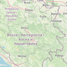
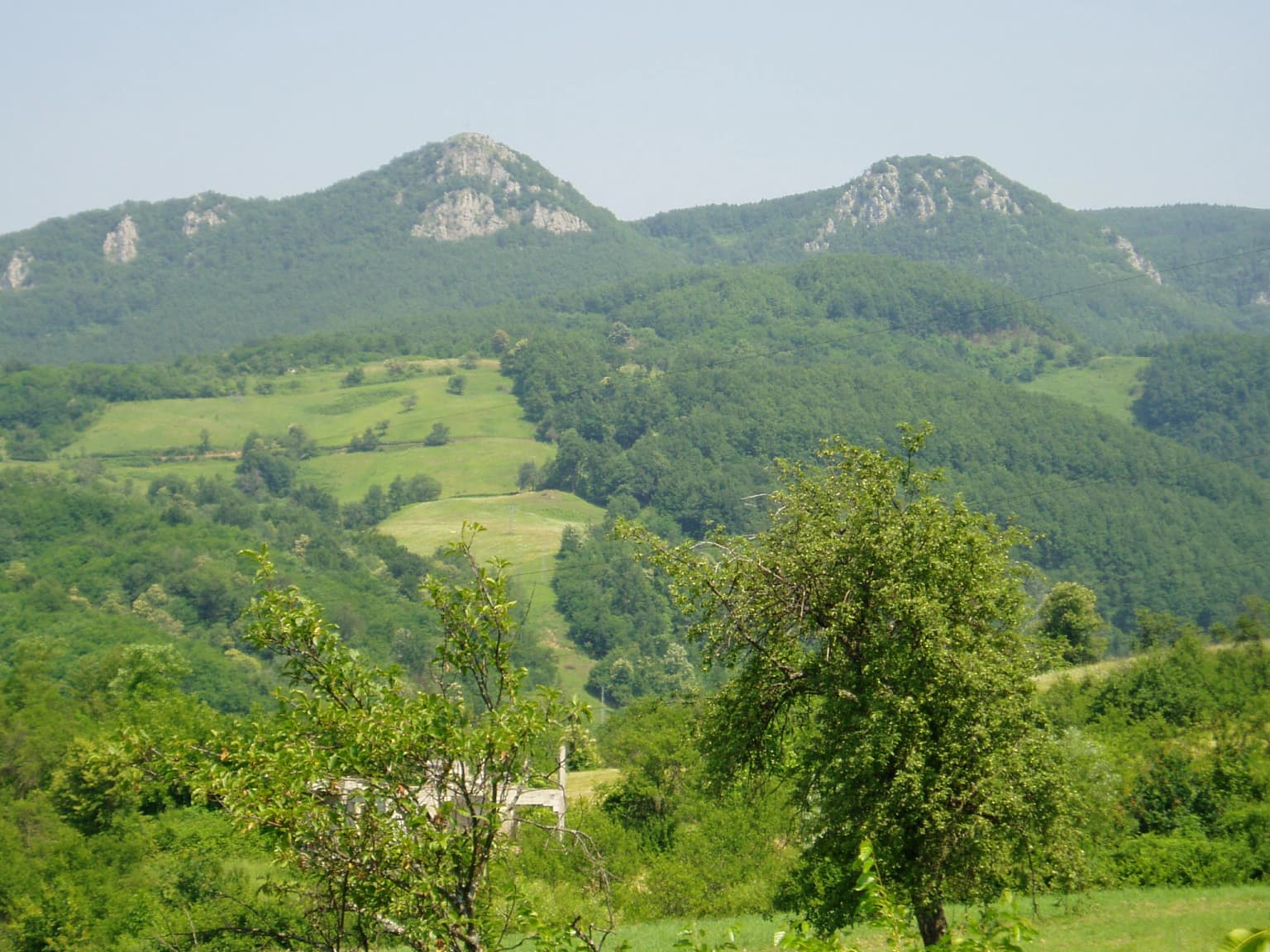
Kozara National Park landscape and geographic character

The Kozara landscape is characterized by a series of rounded, forested ridges and peaks rising from the surrounding lowland plains of the Pannonian basin. The highest point within the park reaches 876 meters at Gola planina, with other significant peaks including Rudine at 750 meters, Jarčevica at 740 meters, Glavuša at 793 meters, and Bešića-poljana at 784 meters. The central Mrakovica area contains several flat or gently sloping plateaus at elevations between 700 and 800 meters, which serve as the primary locations for visitor facilities and the memorial complex. The terrain is cut by numerous small streams and brooks, including Mlječanica, Moštanica, and the Starenice (Kozaračke rijeke), which radiate from the mountain's central watershed. The park's forests alternate with clearings, glades, and meadows, creating a mosaic landscape that varies in character from dense woodland to more open pastoral areas. The surrounding rivers—Una, Sava, Sana, and Vrbas—form a natural boundary to the park and contribute to the visual separation of this forested highland from the agricultural lowlands.

Kozara National Park ecosystems, habitats, and plant life

The ecological diversity of Kozara National Park is remarkable given its relatively modest area of nearly 3,900 hectares. Botanical surveys have documented 865 plant species across the park, including 657 vascular plants, 117 fungi, 11 lichens, and 80 mosses. The forest cover dominates the landscape, with beech and fir forests prevailing in the northern portions, while the southern areas feature lower-growing oak coppices and plantations of conifers including black pine, white pine, and Norway spruce. The park supports 19 documented rare and endangered plant species, including the English yew, lily-of-the-valley, wild cyclamen, Martagon lily, Daphne, hepatica, and several orchid species including the endangered Cephalanthera longifolia. The moderate continental climate supports this diverse flora, with the park functioning as an important hydrological node for the Kozara mountain, collecting and releasing water from numerous springs and streams that feed the surrounding river systems. Approximately 41 percent of the park has been assessed as suitable or very suitable for recreational use, with the most favorable conditions located in the central, northern, and eastern sections.

Kozara National Park wildlife and species highlights

The mammalian fauna of Kozara National Park includes several species typical of Dinaric forest ecosystems. Wild boar represents a significant species in the park's ecosystem, along with roe deer, wild hare, and red fox. European pine marten and stone marten are present among the mustelid species, alongside badger and squirrel. Wild cat, though less commonly observed, inhabits the more remote forest areas. The bird population is notably diverse, with birds of prey including various hawk and kite species and owls represented in the forest and open woodland habitats. Non-raptorial bird species include partridge, wood pigeon, turtle dove, thrushes, warblers, magpie, nightingale, various tit species, and sparrows. The ecological structure of the park—with its mix of forest, clearings, water sources, and the surrounding agricultural landscape—supports this avian diversity and provides habitats for both forest-dwelling and more open-country species.

Kozara National Park conservation status and protection priorities

Kozara National Park holds IUCN Category II designation as a national park, reflecting its primary purpose of protecting natural ecosystems while allowing for sustainable recreational use. The park has also achieved certification from the EUROPARC Federation as an IUCN Category V protected area, recognizing its value for both conservation and recreation. The designation acknowledges the park's successful integration of natural preservation with cultural-historical protection, as the memorial complex represents an important human heritage dimension within the protected landscape. The high percentage of forest cover—88 percent of the park area—represents a significant conservation achievement, maintaining what is essentially the last major forest remnant in the broader Pannonian region of northwestern Bosnia. The documentation and protection of 19 rare and endangered plant species demonstrates active conservation management, while the continued ecological monitoring of the 865 documented species provides a scientific foundation for ongoing protection efforts.

Kozara National Park cultural meaning and human context

The cultural significance of Kozara National Park is deeply intertwined with the events of World War II and the partisan resistance movement in occupied Yugoslavia. The mountain provided strategic terrain for organized resistance against occupying forces, and the Battle of Kozara became a pivotal chapter in the region's wartime history. The memorial complex at Mrakovica serves as the primary expression of this heritage, centered on a monument erected in 1972 followed by the establishment of a museum in 1974 and a memorial wall bearing the names of 9,864 fallen partisan fighters. Unlike many Yugoslav-era memorial sites that emphasized pan-Yugoslav narratives, Kozara was presented primarily as a space of local suffering and resistance, creating a distinct regional identity around the mountain and its defenders. The famous poem "Stojanka majka Knežopoljka," written by Skender Kulenović in 1942, became a cultural testament to the region's wartime experience. Since the 1990s, while commemorative events continue annually on July 4th, the park administration has worked to balance this historical heritage with a broader emphasis on natural recreation and tourism.

Top sights and standout views in Kozara National Park

Kozara National Park offers a distinctive combination of forested mountain landscapes, ecological diversity, and historical significance within a relatively compact protected area. The 300-kilometer trail network provides extensive opportunities for hiking, cycling, and nature exploration across varied terrain from dense forest to open glades. The annual Kozara Marathon and Kozara Ultra Trail attract runners seeking a challenging mountain race, while the UCI-calendar Kozara Grand Prix brings competitive mountain biking to the park's singletrack. The Mrakovica memorial complex provides contemplative heritage tourism focused on WWII history, while the surrounding forest and meadow landscapes support nature observation and photography. The park's proximity to Banja Luka and Prijedor makes it accessible for day trips while also supporting longer stays through camping and cabin accommodations. The spring period, particularly around May 1st, sees the park at its busiest with spontaneous visitor gatherings reaching up to 10,000 people at peak times.

Best time to visit Kozara National Park

Kozara National Park can be enjoyed throughout the year, though each season offers distinct experiences. The spring months of April and May bring forest floors alive with wildflowers and new foliage, creating particularly attractive conditions for hiking and nature observation. May 1st has become a traditional peak visitation day, with large spontaneous gatherings at Mrakovica representing a local cultural practice. Summer offers warm conditions ideal for trail-based activities, though the forest canopy provides welcome shade. The autumn season showcases the park's deciduous forests in rich seasonal colors, making it a particularly scenic time for photography and walking. Winter transforms the landscape, with opportunities for alpine skiing at developed facilities within the park and a quieter, more contemplative atmosphere for those seeking to explore the memorial sites and forest trails without the summer crowds. The moderate continental climate means all seasons present viable options for different types of park experiences.

Park location guide

Geography guide, regional context, and park location map for Kozara National Park

Kozara National Park park geography, regions, and map view in Bosnia and Herzegovina
Understand where Kozara National Park sits in Bosnia and Herzegovina through a broader geographic reading of the surrounding landscape, nearby location context, and its mapped position within the national park landscape.

How Kozara National Park fits into Bosnia and Herzegovina

Bosnia and Herzegovina is a federal parliamentary republic in Southeast Europe on the Balkan Peninsula. It borders Serbia, Montenegro, and Croatia, with a 20-kilometre coastline on the Adriatic Sea. The country has a population of approximately 2.9 million and features diverse geography ranging from mountainous Dinaric Alps in the north to Mediterranean climate in the southern Herzegovina region. Sarajevo serves as the capital and largest city.

Wider geography shaping Kozara National Park in Bosnia and Herzegovina

Bosnia and Herzegovina occupies the central and eastern parts of the Balkan Peninsula. The country is largely mountainous, dominated by the Dinaric Alps in the central and eastern regions. Bosnia occupies the northern and central areas, while Herzegovina covers the southern region. The country has a small coastline along the Adriatic Sea, approximately 20 kilometres long, near the town of Neum.

Map view of Kozara National Park

Use this park location map to pinpoint Kozara National Park in Bosnia and Herzegovina, understand its exact geographic position, and read its mapped placement within the surrounding landscape more clearly.

Pigeon | © OpenStreetMap contributors

Location context for Kozara National Park

Republika Srpska
Park atlas

Expand your geographic perspective: compare protected areas adjacent to Kozara National Park and their surrounding regional landscapes.

National Parks and Protected Areas Near Kozara National Park: Explore Neighboring Landscapes
Browse national parks and protected areas geographically near Kozara National Park, exploring a diverse array of forested mountains, river systems, and regional conservation landscapes. Continue your atlas-style exploration by comparing the unique natural features, ecological diversity, and historical significance that define these adjacent protected areas.
Protected landscapeSisak-Moslavina County

Lonjsko Polje Protected Landscape: Explore Croatia's Largest Inland Wetland and Pastoral Heritage

Discover mapped natural landscapes and unique floodplain geography.

Lonjsko Polje, a significant protected landscape in Croatia's Sisak-Moslavina County, represents the largest inland wetland within the Danube basin. This area is characterized by its vast alluvial floodplain, shaped by seasonal river dynamics, which fosters diverse habitats for wildlife and preserves a rare example of traditional pastoral culture. Explore the mapped geography and understand the ecological importance of this unique wetland ecosystem through structured atlas-style content.

Area
505.6 km²
Established
1998
Relief
Lowland
Climate
Temperate
National park

Una National Park: Bosnia and Herzegovina's Largest National Park and Protected Landscape

Explore its dramatic river canyons and karst geography.

Una National Park represents a significant protected landscape in Bosnia and Herzegovina, covering approximately 198 square kilometers of the Upper Una River basin. This page details the park's protected area identity, focusing on its spectacular riverine geography, including iconic features like the Štrbački Buk waterfall and the deep Unac River canyon. Users can explore the park's mapped boundaries, understand its place within the regional Dinaric mountain context, and discover the characteristics of its unique karst terrain and pristine river ecosystems. MoriAtlas provides essential geographic context for this vital natural area.

Area
350 km²
Established
2008
IUCN
II
Relief
Mixed relief
Watercolor painting of a mountain landscape featuring a river, hills, and vegetation
Nature reservePožega-Slavonia County

Papuk Nature Park: Explore Croatia's Foremost Geopark and Mountain Landscape

Mapped protected area with significant geological heritage in Slavonia.

Papuk Nature Park stands as a cornerstone of geological discovery in Croatia, celebrated as the nation's first UNESCO Global Geopark. Within Požega-Slavonia County, its mountainous terrain features dramatic ridgelines, ancient rock formations like Sokoline stijene, and extensive forests. This protected area offers a unique landscape context for atlas-driven exploration, detailing its mapped boundaries and its critical role in preserving Slavonia's highland geography and geological heritage.

Established
1999
Relief
Highland
Climate
Temperate
Access
Moderate access
National park

Plitvice Lakes National Park: Croatia's Iconic National Park and UNESCO Heritage Site

Mapped protected area with cascading lakes and karst geography.

Delve into the protected landscape of Plitvice Lakes National Park, a jewel of Croatia's natural heritage. This atlas entry highlights the park's famous system of 16 terraced lakes and cascading waterfalls, set within a unique karst terrain. Understand the geographic context and mapped boundaries of this significant protected area, renowned for its geological processes and ancient forest ecosystems. Explore the full spectrum of its protected natural identity.

Watercolor illustration of a landscape with rolling hills, scattered trees, and a winding river.
Protected landscape

Medvednica Nature Park: Mapped Protected Landscape and Central European Karst Geography

Explore protected area boundaries and natural terrain.

Medvednica Nature Park stands as a significant protected landscape, renowned for its complex karst topography and extensive cave networks, including the notable Veternica cave. Located immediately north of Zagreb, Croatia, this park offers a rich tapestry of central European mountain geography, dominated by dense beech and oak forests. Its unique features, such as the karst fields and rounded ridges, contribute to its distinct identity within Croatia's protected areas. MoriAtlas maps its geography, providing context for its ecological value and recreational significance.

Established
1981
Relief
Mountain
Climate
Temperate
Access
Moderate access
National park

Paklenica National Park: Croatia's Iconic Karst Canyon and UNESCO Beech Forests

Explore dramatic protected landscape and regional geography.

Paklenica National Park presents a spectacular protected area defined by its deep karst canyons, with Velika Paklenica and Mala Paklenica carving dramatic vertical walls into the Velebit mountain range. This national park is celebrated for its status as a leading European climbing destination and its ancient beech forests, part of a UNESCO World Heritage site. Exploring Paklenica offers insight into unique geological formations, extensive cave systems, and the rich biodiversity of this significant Croatian landscape.

Area
95 km²
Relief
Mountain
Climate
Mediterranean
Access
Moderate access
National park

Northern Velebit National Park: Croatia's Mapped Protected Landscape Identity

Explore the geography and protected area context.

Northern Velebit National Park stands as a prominent protected area, contributing significantly to the geographic understanding of Croatia's Velebit mountain range. This page provides focused details on its protected landscape features, mapped boundaries, and position within the Dinaric Alps. It serves as an essential entry point for users seeking structured atlas-based information on national parks and their role in regional conservation efforts, highlighting its unique geographic characteristics.

National parkŠibenik-Knin County

Krka National Park: Croatia's National Park with European Cascade Waterfalls

Explore the mapped protected landscape and karst geography.

Krka National Park, designated as a national park in Croatia, offers a rich exploration of its protected landscape. Located in Šibenik-Knin County, the park is defined by the Krka River and its extraordinary seven travertine waterfalls, most notably Skradinski buk, the largest cascade system of its kind in Europe. This atlas-focused view highlights the park's unique karst terrain, Mediterranean ecosystems, and its position within the regional geography, providing essential context for understanding its protected natural heritage.

Area
109 km²
Established
1985
Relief
Lowland
Climate
Mediterranean

Common questions about visiting, size, designation, and location context for Kozara National Park

Kozara National Park FAQs for park facts, access, geography, and protected area context
Find quick answers about Kozara National Park, including protected-area facts, park geography, trail and visitor context, and how the park fits into its surrounding country and regional landscape.
MoriAtlas Explorer

Continue Your Protected Areas Search Across the Global Atlas

Deepen your exploration by continuing the structured search for national parks and protected areas worldwide. Utilize the comprehensive filtering capabilities to compare different conservation landscapes and refine your understanding of global park geography. Discover more about the distribution and characteristics of protected natural areas.

Global natural geography