
Beaches
Park geography
A comprehensive analysis of landscape features, coastal terrain, and forest distribution
Detailed Geographic Profile and Mapped Terrain of Marmaris National Park in Muğla Province
Examine the physical composition and structural boundaries of Marmaris National Park located in the Muğla Province of Turkey. This geographic profile covers the 333.5 square kilometer area, highlighting Mediterranean forest habitats, rugged mountain peaks, and diverse coastal features including bays, beaches, and capes.
Related tags
Mediterranean forestsCoastal national parkEndemic speciesArchaeological sitePine forests
Mediterranean coastal wilderness with ancient Carian heritage
Marmaris National Park
Marmaris National Park is a protected coastal wilderness area situated along the southwestern coast of Turkey in Muğla Province, encompassing the scenic region between the towns of Marmaris and Köyceğiz. Established on 30 January 1996 through a cabinet decision published in the Official Gazette of Turkey, the park covers approximately 33,350 hectares of rugged Mediterranean terrain characterized by pine forests, deep valleys, and dramatic coastlines. The park holds significant ecological importance as part of the World Wildlife Fund's Mediterranean Forests ecoregion, representing one of 200 globally priority ecological regions. Its biodiversity is remarkable, with over 500 plant species documented, including 54 endemic varieties, and a diverse fauna encompassing mammals, birds, reptiles, and insects. The region carries deep historical significance as ancient Caria, with archaeological sites including the ancient cities of Amos and Physcus featuring Hellenistic-era fortifications and a well-preserved Roman amphitheatre. The park receives substantial visitation, with approximately 8.5 million visitors in 2021, drawn to its combination of natural beauty, outdoor recreation opportunities, and cultural heritage.
- Location
- Turkey
- Park type
- National park
- Established
- 1996
- Area
- 333.5 km²
Location overview
Regional context and coastal placement in Muğla Province, Turkey
Marmaris National Park: Geographic Location and Coastal Status
Marmaris National Park is located within Turkey's Muğla Province, serving as a key protected regional territory. The preserve holds designated coastal status and contains no transboundary or island sectors.
- Countries
- Turkey
- Regions
- Muğla Province
- Primary location
- Muğla Province
- Geographic setting
- Coastal
Boundary and coordinates
Mapped spatial outline and derived area measurements
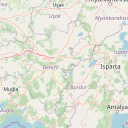
Marmaris National Park Boundary Map and Geographic Extent
Interactive boundary geometry defines the spatial outline and overall layout of the protected territory. Recorded surface dimensions supply supplementary geographic context alongside coordinate spans.
- Boundary area
- 264.3 km²
- Boundary perimeter
- 204.6 km
- Northernmost point
- 36.9285° N
- Southernmost point
- 36.7451° N
- Easternmost point
- 28.5628° E
- Westernmost point
- 28.1945° E
- Geographic centre
- 36.846° N, 28.3638° E
- North–south span
- 20.3 km
- East–west span
- 32.8 km
Terrain and natural features
Stored relief classifications and recorded natural formations
Marmaris National Park Terrain And Named Natural Features
Mixed relief and mountain classifications define the protected terrain across Marmaris National Park. Linked feature cards supply names, types, and spatial relationships for recorded formations within boundaries.
Selected named natural features
Capes
İnce Burun
Peaks
Aktaş Tepe
Capes
Turanlı Burun
Cave entrances
Nimara Cave
Peaks
Kırzeytin Dağı
693 m
Environmental setting
Stored terrain types, Mediterranean climate zones, and forest cover profiles
Marmaris National Park Environmental Classifications and Physical Setting
Recorded habitat types and landscape features combine to frame the physical setting across mixed relief terrain. Connected data categories link specific environmental traits to broader atlas destinations.
- Relief
- Mixed relief
- Climate
- Mediterranean
- Water
- Minor water
- Forest cover
- Mostly forested
- Seasonality
- Year-round
Landscape features
Mountains · Hills · Forest · Coast · Cliffs
Habitat types
Mediterranean forest · Temperate broadleaf forest · Shrubland
Park atlas
Trace the geographic spread of national parks and protected areas across Turkey's compelling Mediterranean region.
Marmaris National Park: Explore Surrounding Protected Areas and Connected Mediterranean Landscapes
Browse national parks and protected areas near Marmaris National Park, tracing Turkey's scenic Mediterranean coastline and diverse inland landscapes. Compare their distinct ecosystems, geological formations, and ancient sites to understand the regional conservation context and broader protected-area geography.
National parkMuğla Province
About 84 km away#1 closest
Southeast

Saklıkent National Park: Explore Turkey's Deepest Gorge, Limestone Formations, and Protected Terrain
A remarkable national park showcasing dramatic canyon geography and karst landscapes.
Saklıkent National Park presents an extraordinary example of a protected landscape dominated by a deep limestone canyon in Muğla Province, Turkey. This national park invites exploration of its striking geological features, including towering cliffs and flowing karstic springs that form a spectacular gorge. Users engaging with Saklıkent National Park gain insight into the mapped boundaries of protected areas and the unique natural terrain sculpted by water over millennia, offering a rich geographic context for atlas discovery.
- Area
- 16.43 km²
- Established
- 1996
- IUCN
- II
- Visitors
- 200K annual

National parkTurkey
About 108 km away#2 closest
Northeast
Mount Honaz National Park: Turkey's National Park Protected Area Detail
Explore mapped protected landscape and regional geography.
Mount Honaz National Park is a designated national park in Turkey, offering valuable insights into the country's protected areas and natural landscapes. This page provides a focused view of its mapped boundaries and geographic significance, enabling detailed atlas-style exploration. Understand how this protected area contributes to the regional geography of Western Anatolia and complements the broader network of natural reserves within Turkey.
- IUCN
- II
- Scope
- Terrestrial
National parkAydın Province
109 km away#3 closest
Northwest
Dilek Peninsula-Büyük Menderes Delta National Park: Protected Landscape and Geographic Context
Aydın Province's unique national park with diverse ecosystems.
Investigate Dilek Peninsula-Büyük Menderes Delta National Park, a key protected area in Turkey's Aydın Province. This page provides detailed geographic context, highlighting the park's remarkable coexistence of mountainous terrain and essential wetland habitats. Understand the mapped boundaries and landscape characteristics that define this significant national park.
- Area
- 275.98 km²
- Established
- 1966
- IUCN
- II
- Visitors
- 700K annual
National parkAntalya Province
170 km away#4 closest
East
Beydağları Coastal National Park: Protected Landscape and Geographic Atlas
Explore mapped boundaries and natural terrain in Antalya Province.
Beydağları Coastal National Park is a significant protected national park located along the Mediterranean coast of Antalya Province, Turkey. This page provides an atlas-focused view of the park, detailing its geographic scope, the interplay of mountain and coastal landscapes, and its importance as a protected area. Users can delve into the mapped features and regional context that define this remarkable natural and historical landscape.
- Area
- 344.25 km²
- Established
- 1972
- IUCN
- II
- Relief
- Mountain
National parkAntalya Province
About 173 km away#5 closest
East
Mount Güllük-Termessos National Park: An Atlas View of Protected Mediterranean Landscapes
Protected national park with ancient ruins and diverse ecosystems.
Discover Mount Güllük-Termessos National Park, a key protected area within Antalya Province, Turkey. This national park is notable for its integrated cultural and natural heritage, featuring the extensive ruins of ancient Termessos and a diverse Mediterranean ecosystem supporting endangered wildlife. Its varied terrain, from lower shrublands to higher pine forests, alongside dramatic geological features like the Mecene Strait canyon, provides rich geographic context for atlas-based discovery.
- Area
- 67.02 km²
- Established
- 1970
- IUCN
- II
- Relief
- Mountain
National parkTurkey
About 197 km away#6 closest
North
Mount Spil National Park: Turkey's National Park and Protected Landscape Atlas Entry
Explore its mapped boundaries and regional geographic context.
Mount Spil National Park is presented here as a key protected area within Turkey's atlas of natural landscapes. This detail page focuses on its identity as a national park, providing a structured overview of its mapped boundaries and geographic setting. Understand its landscape context and its significance within Turkey's network of protected lands for detailed atlas exploration and geographic discovery.
- IUCN
- II
- Scope
- Mixed
- Water
- Minor water
National parkIsparta Province
About 221 km away#7 closest
East
Lake Kovada National Park: Mapped Protected Landscape in Isparta Province
Discover the geography and lake ecosystem of this Turkish national park.
Lake Kovada National Park offers a detailed look at a protected natural area within Turkey's Isparta Province. This page provides insights into the park's protected landscape, focusing on the central freshwater lake and its surrounding montane terrain. Explore its geographic context, mapped boundaries, and status as a significant protected area within the Taurus Mountain region, ideal for atlas-based discovery of Anatolian natural environments.
- Area
- 65.51 km²
- Established
- 1970
- IUCN
- II
- Scope
- Terrestrial
National parkTurkey
About 240 km away#8 closest
East
Köprülü Canyon National Park: Protected Landscape Atlas and Geographic Context
Discover unique geological formations and river canyon terrain.
Köprülü Canyon National Park represents a vital protected natural area, showcasing remarkable geological formations and a dramatic river canyon landscape. This entry provides a structured exploration of its mapped boundaries, regional geographic setting, and the unique terrain that defines this significant natural reserve, ideal for atlas-based discovery.
- IUCN
- II
MoriAtlas Explorer
Continue Exploring Marmaris National Park's Geographic Context and Protected Landscape
Dive deeper into the structured atlas data for Marmaris National Park. Understand its precise geographic setting within Muğla Province, its mapped protected boundaries, and the unique landscape features that define this significant natural area. MoriAtlas provides the foundation for detailed discovery of its ecological and historical dimensions, offering a clear perspective on its place in regional geography.
Browse next
Global natural geography
Explore related park routes
Explore MoriAtlas Global ParksBrowse All MoriAtlas ParksGlobal Park Map DiscoveryMoriAtlas: Browse All CountriesBrowse All MoriAtlas ContinentsNational Park Environment AtlasGrand Canyon National Park AtlasYellowstone National Park AtlasYosemite National Park Atlas and GeographySerengeti National Park AtlasGalápagos National Park Protected LandscapeBanff National Park Geography and AtlasKruger National Park Atlas EntryUluṟu-Kata Tjuṯa National Park AtlasExplore Uluru-Kata Tjuta National Park GeographyPlitvice Lakes National Park AtlasFiordland National Park Protected LandscapeGreat Smoky Mountains National Park AtlasAfghanistan National Parks and Protected AreasAlbania National Parks and Protected AreasAlgeria National Parks and Protected AreasAmerican Samoa National Parks and Protected AreasAndorra National Parks and Protected AreasAngola National Parks and Protected AreasAntarctica National Parks and Protected AreasAntigua and Barbuda Park List