Mori Atlas logo
National parkNamtok Phlio National Park

Explore the mapped boundaries and regional geography of this national park in Chanthaburi Province.

Namtok Phlio National Park: Protected Landscape Identity and Geographic Context

Namtok Phlio National Park stands as a key protected area within Thailand's Chanthaburi Province. This detailed page provides an atlas-driven exploration of its identity as a national park, focusing on its mapped geographic scope and the surrounding landscape context. Understand the protected boundaries and regional geography that define Namtok Phlio National Park for structured discovery on MoriAtlas.

National ParkWaterfallKarst LandscapeTropical RainforestEastern ThailandCardamom Mountains

Namtok Phlio National Park

National park

Park overview

Structured park overview, official facts, and landscape profile for Namtok Phlio National Park

Namtok Phlio National Park park facts, protected area profile, and essential visitor context
Review the core facts for Namtok Phlio National Park, including designation, size, terrain, visitor scale, habitats, and operating context in one park-focused overview.

About Namtok Phlio National Park

Namtok Phlio National Park occupies a mountainous region in eastern Thailand that forms part of the Cardamom Mountains, a major mountain system extending through mainland Southeast Asia. The park's terrain is characterized by karst limestone formations that have been extensively eroded over geological time, creating a landscape of steep ridges, cliffs, and hidden valleys. Despite the relatively modest maximum elevation of 925 meters, the area supports a complex ecosystem within its tropical rainforest, with vegetation adapted to the moist, shaded conditions of the mountain slopes and valley floors. The park's location in Chanthaburi Province places it within one of Thailand's more botanically diverse regions, where moisture patterns from the Gulf of Thailand and annual rainfall support lush forest cover throughout the year. The establishment of the protected area in 1975 reflected growing recognition of the need to preserve Thailand's remaining forested landscapes, while the renaming in 1982 to Namtok Phlio emphasized the waterfall that serves as the park's primary visitor attraction.

Quick facts and research context for Namtok Phlio National Park

Namtok Phlio National Park is located about 14 kilometers south of Chanthaburi town and spans four districts: Mueang Chanthaburi, Laem Sing, Khlung, and Makham. The park was originally declared as Khao Sa Bap National Park in May 1975 and renamed to Namtok Phlio National Park in September 1982. The area features tropical rainforest covering diverse tree species including Aquilaria crassna, Shorea henryana, Hopea ferrea, and Dipterocarpus turbinatus. Wildlife includes Sunda pangolin, lar gibbon, pig-tailed macaque, northern red muntjac, common palm civet, serow, chevrotain, and wild boar, along with abundant birdlife such as hornbills, imperial pigeons, and crested serpent eagles. The park received approximately 671,000 visitors in 2019.

Park context

Deeper park guide and search-rich context for Namtok Phlio National Park

Namtok Phlio National Park history, landscape, wildlife, and travel context
Explore Namtok Phlio National Park through its history, landscape character, ecosystems, wildlife, conservation priorities, cultural context, and seasonal travel timing in a structured park guide built for atlas discovery and search intent.

Why Namtok Phlio National Park stands out

Namtok Phlio is best known for its namesake waterfall, where cascading waters create a series of pools that are home to large populations of soro brook carp, a distinctive fish species found in these particular mountain streams. The karst landscape of Khao Sa Bap, with its heavily eroded limestone formations, represents a rare example of this geological type within Thailand's protected area system and forms a visual backbone to the park's identity. The combination of natural waterfall scenery with historic Buddhist monuments, particularly the King Rama V-era chedi and stupa near the falls, creates a unique blend of ecological and cultural attraction that distinguishes the park from other Thai national parks.

Namtok Phlio National Park history and protected-area timeline

The area now within Namtok Phlio National Park has historical significance dating to the reign of King Rama V in the late nineteenth century. In 1876, the Along Khon chedi was constructed in the mountainous terrain, representing the king's interest in establishing religious monuments in strategically chosen natural settings. In 1881, King Rama V commissioned a memorial stupa to house a relic of Princess Sunanta Kumari, further cementing the area's cultural and spiritual importance. The area remained relatively undeveloped and forested through the mid-twentieth century. On 2 May 1975, the Thai government declared the region a national park under the name Khao Sa Bap National Park, recognizing both its natural landscape and historical features. The park was officially renamed Namtok Phlio National Park on 29 September 1982, adopting the name of the Phlio Waterfall that had become the primary landmark and visitor destination within the protected area.

Namtok Phlio National Park landscape and geographic character

The landscape of Namtok Phlio National Park is defined by the Khao Sa Bap mountain range, a series of heavily eroded karst limestone peaks that represent the western termination of the Cardamom Mountains as they extend from Cambodia into Thailand. These formations create a distinctive terrain of steep, often craggy ridgelines with numerous rock outcrops and cliff faces. The highest point reaches 925 meters at Map Wa Krok peak, though most of the terrain consists of ridges and slopes between 400 and 800 meters elevation. The underlying limestone geology has produced numerous sinkholes, caves, and underground drainage systems typical of karst landscapes. Seasonal streams and waterfalls descend the mountain slopes, with the Phlio Waterfall being the most prominent and permanent water feature. The forest cover extends from the valley floors up the slopes, with the deepest vegetation occurring in the ravines and lower slopes where moisture accumulates.

Namtok Phlio National Park ecosystems, habitats, and plant life

Namtok Phlio National Park supports tropical rainforest vegetation across its elevation range, with the canopy dominated by dipterocarp trees along with other significant species. The forest includes Aquilaria crassna, a tree species valued for its aromatic resin, Shorea henryana and Hopea ferrea, both important timber species within the dipterocarp family, and Dipterocarpus turbinatus. Other notable trees include Pterocymbium tinctorium, Garcinia celebica, and Garcinia cowa, which contribute to the forest's structural and species diversity. The moist conditions created by the mountain terrain and annual rainfall patterns support epiphytic plants, ferns, and other moisture-loving vegetation throughout the understory. The karst geology influences soil chemistry and water drainage, creating microhabitats that support specialized plant communities adapted to the limestone substrate.

Namtok Phlio National Park wildlife and species highlights

The mammalian fauna of Namtok Phlio National Park includes several species of conservation significance. The Sunda pangolin, a scaly mammal that feeds on insects, inhabits the forest, along with arboreal primates including the lar gibbon. Populations of pig-tailed macaque and northern red muntjac are present throughout the forested areas. The common palm civet occupies tree hollows and forages in the canopy, while the serow, a mountain-dwelling hoofed mammal, is found on the steeper rocky slopes. Smaller mammals include chevrotains and wild boar. The bird community is particularly diverse, with numerous species recorded including herons, brahminy kites, shikras, crested serpent eagles, and besra among the raptors. The park supports populations of imperial pigeons, various dove species including red turtle dove and emerald dove, hornbills, barbets, and the colorful vernal hanging parrot. Common resident birds include hill mynas, bulbuls, white-rumped shamas, and numerous woodpecker and drongo species.

Namtok Phlio National Park conservation status and protection priorities

Namtok Phlio National Park serves as a protected area for the karst forest ecosystem of the Khao Sa Bap mountains, preserving an example of this geological and ecological landscape type within Thailand's protected area network. The park's tropical rainforest harbors biodiversity that faces pressure from habitat conversion and fragmentation in the surrounding lowland regions. Conservation of the watershed areas feeding the Phlio Waterfall and other streams is important for maintaining water quality downstream. The presence of the soro brook carp in the waterfall pools indicates successful protection of aquatic habitat conditions necessary for this species. The park also protects the traditional Buddhist monuments, ensuring that cultural and natural heritage are maintained together within a coherent protected landscape.

Namtok Phlio National Park cultural meaning and human context

The cultural significance of Namtok Phlio National Park is closely tied to the Buddhist religious monuments constructed during the reign of King Rama V in the late nineteenth century. The Along Khon chedi, built in 1876, represents a period when royal patronage extended to establishing religious structures in mountainous natural settings throughout the kingdom. The memorial stupa commissioned in 1881 to house a relic of Princess Sunanta Kumari reflects Buddhist traditions of relic preservation and merit-making that were integrated with the natural landscape. These structures are located near the Phlio Waterfall, creating a cultural circuit that visitors can follow from the falls to the historic chedi and stupa. The mountain name Khao Sa Bap carries local significance and reflects the area's identity in regional cultural geography.

Top sights and standout views in Namtok Phlio National Park

The Phlio Waterfall stands as the park's premier attraction, with its cascade of tiered pools offering both scenic beauty and the notable presence of soro brook carp swimming in the clear waters. The karst mountains of Khao Sa Bap provide a distinctive geological backdrop, with their erosion-formed peaks and cliffs offering visual interest different from Thailand's more common granite mountain landscapes. The King Rama V-era Buddhist monuments near the waterfall add a cultural dimension that most Thai national parks lack, combining natural exploration with historical sightseeing. The network of additional waterfalls, including Khlong Narai, Makok, and Trok Nong, extends the park's natural attractions beyond the main Phlio site. The tropical rainforest trails through the karst terrain allow visitors to experience the dense vegetation and spot wildlife in one of eastern Thailand's less-visited protected areas.

Best time to visit Namtok Phlio National Park

The optimal time to visit Namtok Phlio National Park is during the cool dry season from November through February, when temperatures are lower and rainfall is reduced, making trail conditions more comfortable and wildlife activity more predictable. The park receives most of its annual rainfall during the monsoon season from May through October, when some trails may become slippery and stream crossings more difficult, though the waterfalls typically flow with maximum volume during this period. The hot season from March to April can be challenging for hiking, with higher temperatures and reduced water availability in smaller streams. The Phlio Waterfall is accessible year-round, though the surrounding area is most pleasant during the cooler months. Visitors interested in birdwatching will find the dry season months particularly productive, as resident bird species remain active and more visible in the thinning vegetation.

Park location guide

Geography guide, regional context, and park location map for Namtok Phlio National Park

Namtok Phlio National Park park geography, regions, and map view in Thailand
Understand where Namtok Phlio National Park sits in Thailand through a broader geographic reading of the surrounding landscape, nearby location context, and its mapped position within the national park landscape.

How Namtok Phlio National Park fits into Thailand

Thailand is a Southeast Asian nation formerly called Siam, located in mainland Southeast Asia. It operates as a unitary parliamentary constitutional monarchy under King Vajiralongkorn. The country borders Myanmar, Laos, Cambodia, and Malaysia, with maritime boundaries involving Vietnam, Indonesia, and India. Thailand has a population of nearly 66 million and covers approximately 513,120 km². Historically, the Sukhothai Kingdom marks the beginning of Thai history, followed by the powerful Ayutthaya Kingdom.

Wider geography shaping Namtok Phlio National Park in Thailand

Thailand occupies mainland Southeast Asia with borders to Myanmar (west/northwest), Laos (east/northeast), Cambodia (southeast), and Malaysia (south). The country has coastline along the Gulf of Thailand to the southeast and the Andaman Sea to the southwest. The territory covers approximately 513,120 km².

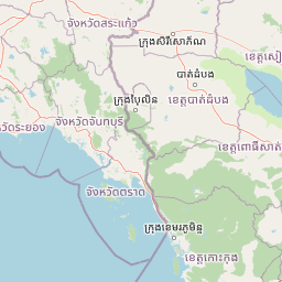
Map view of Namtok Phlio National Park

Use this park location map to pinpoint Namtok Phlio National Park in Thailand, understand its exact geographic position, and read its mapped placement within the surrounding landscape more clearly.

Pigeon | © OpenStreetMap contributors

Location context for Namtok Phlio National Park

Chanthaburi Province
Park atlas

Trace the regional protected area geography, comparing diverse landscapes around Namtok Phlio National Park.

Discover Nearby National Parks and Protected Landscapes Around Namtok Phlio National Park
Explore national parks and protected areas located near Namtok Phlio National Park, tracing the broader conservation geography of eastern Thailand's diverse landscapes. Comparing these regional protected areas allows for deeper insights into the distinct terrain, ecological features, and conservation efforts across the Cardamom Mountains system.
National parkThailand

Khao Khitchakut National Park: Protected Area Geography and Mapped Boundaries in Thailand

Explore the natural landscape and park map context.

Khao Khitchakut National Park is a protected national park in Thailand, offering specific geographic context for atlas exploration. This entry details the park's mapped boundaries and its role within the regional landscape. Understand the protected area's physical geography and its place within Thailand's mapped conservation network. It's a key point for exploring the natural terrain and protected lands.

Area
59 km²
Established
1977
IUCN
II
Visitors
1.2M annual
Watercolor landscape showing rolling hills, mountains, and a body of water with trees and vegetation
National parkThailand

Mu Ko Chang National Park: Thailand's National Park Landscape and Protected Area Geography

Mapped boundaries and regional context for this Thai national park.

Delve into the geography of Mu Ko Chang National Park, a vital national park located in Thailand. This page provides an atlas-level view of its protected area status, mapped boundaries, and its significance within the broader landscape of Southeast Asia. Understand the park's unique role as a conserved natural region through structured geographic data and detailed landscape context.

Area
650 km²
Established
1982
IUCN
II
Visitors
249.9K annual
National parkRayong Province

Khao Chamao, Khao Wong National Park: Protected Area Atlas and Mountain Landscape Context

Rayong Province's vital national park with mapped terrain and waterfalls.

Delve into the geography of Khao Chamao, Khao Wong National Park, a designated national park in Thailand's Rayong Province, forming a western extension of the Cardamom Mountains. This page provides detailed mapped context for its protected boundaries, forested hills, and prominent peaks, highlighting its importance as a habitat and an atlas entry for understanding regional landscapes. Explore the park's terrain and its role in conservation.

Area
84 km²
Established
1975
IUCN
II
Visitors
218.4K annual
Watercolor painting showing green hills, purple mountains, and a calm water body with sparse vegetation
National parkRayong Province

Khao Laem Ya, Mu Ko Samet National Park: Marine National Park and Protected Island Geography

Coastal terrain and archipelago mapped within Rayong Province.

Delve into Khao Laem Ya, Mu Ko Samet National Park, a significant marine protected area located in Rayong Province, Thailand. This atlas entry highlights the park's archipelago of islands, including Ko Samet, its mainland coastal features like Khao Laem Ya, and the surrounding Gulf of Thailand waters. Understand the park's role in coastal conservation, its mapped marine environments, and its unique blend of terrestrial and aquatic protected landscapes for geographic discovery.

Area
131 km²
Established
1981
IUCN
II
Visitors
1.6M annual
National parkCambodia

Central Cardamom Mountains National Park: Cambodia's Premier Protected Rainforest Landscape

Explore Extensive Rainforest, Diverse Habitats, and Mountain Terrain

Central Cardamom Mountains National Park is Cambodia's largest protected area, a testament to significant rainforest conservation efforts. This national park spans approximately 4,010 square kilometers, showcasing a dynamic mountainous landscape with diverse ecological zones from coastal areas to peaks over 1,500 meters. Discover the geographic distribution of its protected boundaries and the rich tapestry of habitats that define this vital Southeast Asian natural reserve, offering deep context for atlas-based exploration.

Area
4,010.65 km²
Established
1999
IUCN
II
Relief
Mountain
National parkSa Kaeo Province

Pang Sida National Park: Protected Landscape Atlas in Sa Kaeo Province

Discover its mapped terrain and wildlife habitats.

Pang Sida National Park is a significant protected national park located in Sa Kaeo Province, Thailand, spanning approximately 844 square kilometers of the Sankamphaeng Range. As a critical element of the UNESCO Dong Phayayen-Khao Yai Forest Complex, it provides a vital protected landscape for diverse ecosystems and remarkable biodiversity. Users can explore the park's mountainous terrain, grasslands, and riparian zones, gaining insight into its geographic significance and its role within a larger conservation area.

Area
844 km²
Established
1982
IUCN
II
Visitors
58.4K annual
Watercolor painting showing green hills, pinkish mountains, and two trees in a scenic landscape
National parkSa Kaeo Province

Ta Phraya National Park: National Park & Protected Landscape Geography in Sa Kaeo Province

Explore the mapped boundaries and regional terrain of this Thai national park.

Ta Phraya National Park stands as a protected national park within the dynamic geography of Sa Kaeo Province, Thailand. This page offers an atlas-centric view, detailing the park's specific geographic footprint and its contribution to the regional landscape. Understanding Ta Phraya National Park's position, its mapped natural terrain, and its designation as a protected area is crucial for grasping Thailand's broader conservation geography.

Area
594 km²
Established
1996
IUCN
II
National parkThailand

Thap Lan National Park: Mapping Thailand's Protected Landscape Identity

Explore the mapped geography and protected area context.

Thap Lan National Park represents a vital element of Thailand's network of protected lands. This page offers an atlas-focused view of its geographic position and landscape character within the country. Users can uncover details about the park's mapped boundaries and its significance as a protected natural area. Understand its place in the broader context of Thai geography and conservation, enabling structured exploration of its natural terrain.

Area
2,236 km²
Established
1981
IUCN
II
Visitors
57.1K annual

Common questions about visiting, size, designation, and location context for Namtok Phlio National Park

Namtok Phlio National Park FAQs for park facts, access, geography, and protected area context
Find quick answers about Namtok Phlio National Park, including protected-area facts, park geography, trail and visitor context, and how the park fits into its surrounding country and regional landscape.
MoriAtlas Explorer

Continue Your Protected Areas Search Across the Global Atlas

Deepen your exploration by continuing the structured search for national parks and protected areas worldwide. Utilize the comprehensive filtering capabilities to compare different conservation landscapes and refine your understanding of global park geography. Discover more about the distribution and characteristics of protected natural areas.

Global natural geography