
Mori Atlas logo
National parkOnezhskoye Pomorye National Park

Examining the ecological transition from ancient boreal forests to the marine landscape of the White Sea.

Onezhskoye Pomorye National Park: An Atlas of Protected Taiga and Coastal Wilderness in Russia

(National Park Onezhskoye Pomorye)

Onezhskoye Pomorye National Park represents a critical protected area in Arkhangelsk Oblast, encompassing the vast majority of the Onega Peninsula. This territory serves as a significant reference point for European wilderness, featuring one of the continent's largest continuous expanses of untouched old-growth taiga forests. The landscape is defined by the intersection of boreal woodlands and the marine environments of the White Sea, creating a unique coastal-terrestrial ecosystem largely unmodified by human development.

taiga forestsold-growth forestWhite Seaboreal ecosystemscoastal protected areanorthern Russia
Illustration depicting a mountainous river valley with forests, a waterfall, and a sunset

Onezhskoye Pomorye National Park

National park

Park overview

Structured park overview, official facts, and landscape profile for Onezhskoye Pomorye National Park

Onezhskoye Pomorye National Park park facts, protected area profile, and essential visitor context

Review the core facts for Onezhskoye Pomorye National Park, including designation, size, terrain, visitor scale, habitats, and operating context in one park-focused overview.

About Onezhskoye Pomorye National Park

Onezhskoye Pomorye National Park occupies the Onega Peninsula in the northern Arkhangelsk Oblast region of Russia, a remote area where the boreal forest ecosystem reaches its westernmost extent along the White Sea. The park's establishment represents Russia's commitment to preserving old-growth taiga ecosystems, which in this location extend from inland forest to the very edge of the marine coastline, creating a seamless transition between terrestrial and coastal environments. The peninsula's isolation from the mainland has been a defining characteristic that shaped both its ecological condition and human settlement patterns. Without all-season road access, the peninsula remained relatively untouched by industrial development that transformed other parts of northern Russia's forest belt. The park's boundaries encompass both the terrestrial forest ecosystems and the adjacent marine waters of the White Sea, recognizing that the ecological integrity of the region depends on the connection between land and sea. The protected area is managed under IUCN Category II designation, reflecting its national park status and the dual mandate of preserving both natural ecosystems and supporting compatible recreational and educational uses.

Quick facts and research context for Onezhskoye Pomorye National Park

The park covers 2,016.68 square kilometers along the Onega Peninsula in Arkhangelsk Oblast, making it a substantial protected area in Russia's northern European territories. It was formally established in February 2013 following a lengthy creation process that began in 1997. The protected area includes both forest fund lands comprising the majority of the territory and water fund lands associated with the adjacent White Sea. The nearest communities are Onega and Severodvinsk, though the peninsula lacks year-round land connections to the mainland.

Protection and recognition

Examine the documented protection status and management scope of Onezhskoye Pomorye National Park

Onezhskoye Pomorye National Park Protection Status and Recognition Data

Onezhskoye Pomorye National Park features a mixed protection scope governed by established conservation frameworks. Review structured records detailing international recognition sources and official protected area designations for this northern landscape.

Protection details

Protection scope
Mixed
Transboundary protection
No
Park context

Deeper park guide and search-rich context for Onezhskoye Pomorye National Park

Onezhskoye Pomorye National Park history, landscape, wildlife, and travel context

Explore Onezhskoye Pomorye National Park through its history, landscape character, ecosystems, wildlife, conservation priorities, cultural context, and seasonal travel timing in a structured park guide built for atlas discovery and search intent.

Why Onezhskoye Pomorye National Park stands out

Onezhskoye Pomorye is recognized as containing the largest continuous expanse of untouched old-growth taiga forests in Europe, a distinction that extends the distinction of European wilderness to the marine coastline. The park is also notable for its cultural heritage, preserving historic Pomor settlements and wooden churches constructed between the 17th and 19th centuries, alongside the 19th-century Chesmensky and Orlovsky lighthouses that mark the challenging White Sea navigation routes.
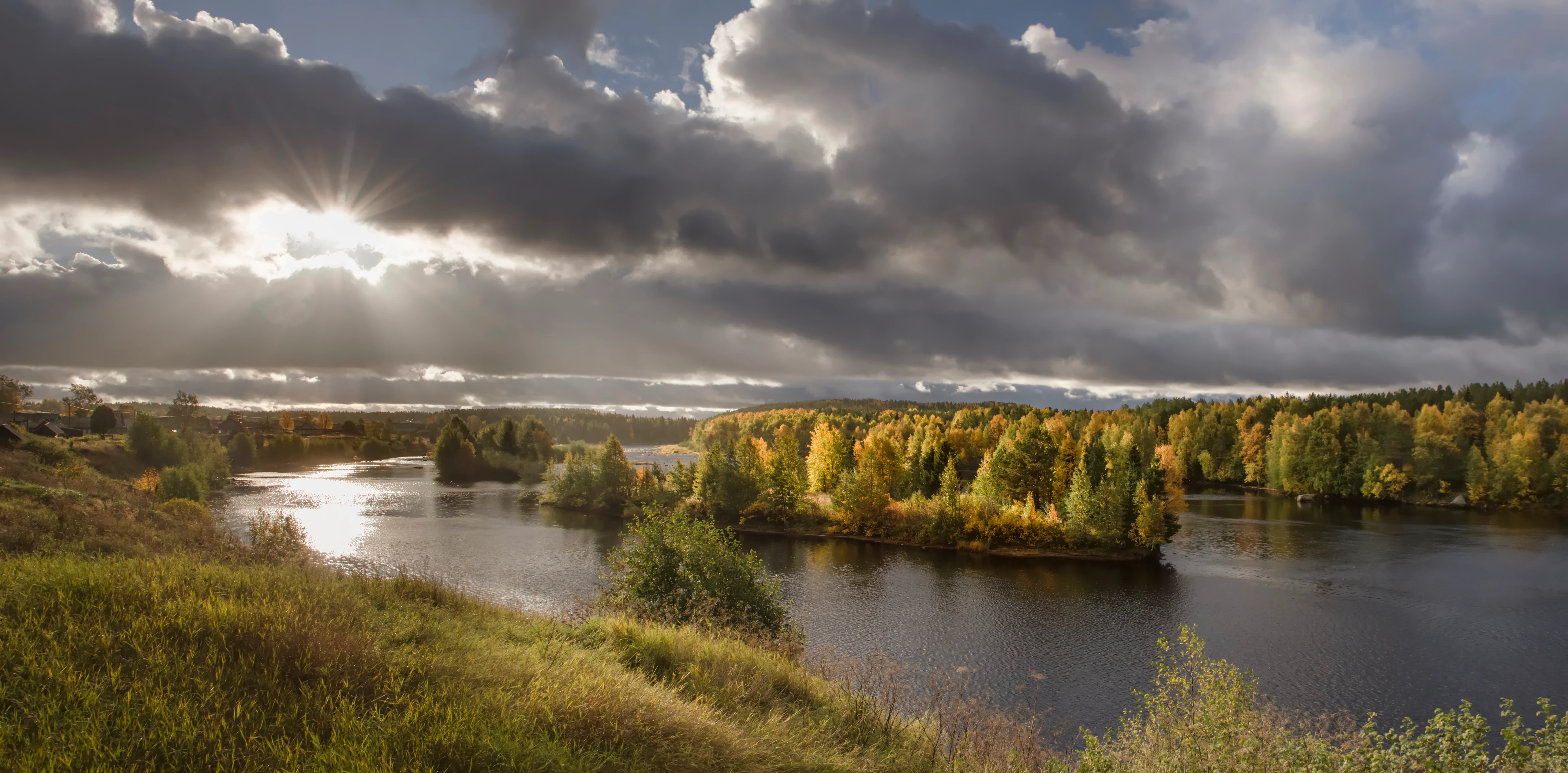
Panoramic view of a river with autumn-colored trees, grassy hills, and dramatic clouds with sunlight breaking through
Autumn landscape of the Zolotitsa River in Onezhskoye Pomorye National Park

Onezhskoye Pomorye National Park history and protected-area timeline

The creation of Onezhskoye Pomorye National Park unfolded over a extended period reflecting the complexity of establishing protected areas in Russia's federal system. Initial efforts to establish the park began in 1997, though the process of boundary approval required five years to resolve, with boundaries finally approved in 2002. Following this approval, the land was reserved for future national park status while management frameworks and resource surveys were completed. The formal government decision to create the national park was made on December 22, 2011, and the park was officially established on February 26, 2013. This lengthy creation process reflected both the scale of the protected area and the need to coordinate between different levels of government and administrative bodies with jurisdiction over the peninsula's lands and waters.

Onezhskoye Pomorye National Park landscape and geographic character

The landscape of Onezhskoye Pomorye is defined by the intersection of two major environmental zones: the boreal taiga forest that covers the Russian north and the marine environment of the White Sea. The Onega Peninsula extends into the sea as a landform characterized by gently rolling terrain typical of glaciated landscapes in northwestern Russia. Forest dominates the terrestrial portion of the park, with old-growth trees forming a continuous canopy across the peninsula. The coastline varies between rocky shores and more gradual beach transitions where the forest meets the water. In winter, the White Sea freezes completely, transforming the marine environment into an extension of the terrestrial winter landscape and creating seasonal conditions that shape both ecological processes and human activity in the region.

Onezhskoye Pomorye National Park ecosystems, habitats, and plant life

The ecological character of Onezhskoye Pomorye centers on old-growth taiga forests that represent some of the most intact forest ecosystems remaining in Europe. These forests exhibit the structural complexity characteristic of unmodified boreal systems, including multiple canopy layers, standing dead trees, fallen logs, and the accumulated organic matter of centuries. The forest composition reflects the northern boreal environment with species adapted to cold climates and short growing seasons. The transition to marine environments at the coastline creates ecological gradients where terrestrial species encounter the influences of saltwater, tidal patterns, and maritime climate. This boundary zone supports specialized species adapted to the interface between forest and sea ecosystems.

Onezhskoye Pomorye National Park wildlife and species highlights

The terrestrial wildlife of Onezhskoye Pomorye includes species characteristic of the northern taiga, with moose, Eurasian brown bear, gray wolf, and red fox all common within the park boundaries. These large mammals represent the core of the park's vertebrate fauna and reflect the ecological health of the forest ecosystem. Marine wildlife in the adjacent White Sea includes beluga whales, which inhabit the Arctic and sub-Arctic waters and are present in the White Sea despite its relatively southern position within the species' range. The combination of terrestrial and marine protected habitat creates opportunities for species that move between land and sea ecosystems, while the overall isolation of the peninsula from intensive human activity has allowed wildlife populations to persist at natural density levels.

Onezhskoye Pomorye National Park conservation status and protection priorities

Onezhskoye Pomorye represents a flagship conservation designation within Russia, protecting what is identified as the largest remaining expanse of untouched old-growth taiga forest in Europe. The park's conservation significance is amplified by the forest's extension to the marine coastline, creating a protected area that encompasses the complete ecological transition from boreal forest to marine environments. This comprehensive protection is increasingly rare in Europe's heavily modified landscape, where most coastal areas have experienced extensive human development. The park's dual conservation mandate extends to the cultural landscape, recognizing that the Pomor settlements, historic wooden churches, and navigational lighthouses represent human heritage that exists in dynamic relationship with the natural environment.

Onezhskoye Pomorye National Park cultural meaning and human context

The Onega Peninsula has been inhabited by the Pomors, a distinctive community of northern Russian coastal dwellers with a unique cultural identity shaped by their relationship to the sea and the forest. The park preserves evidence of this cultural heritage in the form of historic settlements, traditional wooden churches dating from the 17th through 19th centuries, and the navigational infrastructure represented by the Chesmensky and Orlovsky lighthouses. These cultural elements reflect centuries of human adaptation to the challenging but resources-rich environment of the northern Russian coast. The communities maintained connections through maritime activity, fishing, and forest resource use, creating a cultural landscape that is inseparable from the natural environment the park now protects.

Top sights and standout views in Onezhskoye Pomorye National Park

The park's most significant highlight is its status as Europe's largest tract of untouched old-growth taiga forest extending to the sea, a distinction that positions it as a reference point for boreal wilderness conservation on the continent. The cultural heritage elements, including historic wooden churches and coastal lighthouses, add cultural depth to the natural landscape, creating a combined natural-cultural protected area. The isolation of the peninsula, while presenting access challenges for visitors, has preserved ecological integrity that is increasingly rare in populated regions of Europe.

Best time to visit Onezhskoye Pomorye National Park

The park can be visited throughout the year, though the experience differs substantially between seasons. Winter brings complete freezing of the White Sea and heavy snow cover across the forest, creating a dramatically different landscape from the ice-free season. Summer offers the most accessible period for exploration, though visitors must obtain permits in advance and are limited to ten-day stays except for local residents who may remain longer.

Monthly climate preview

Long-term representative coordinate measurements for temperature and precipitation patterns

Onezhskoye Pomorye National Park Climate Normals and Annual Temperature Rhythm

Onezhskoye Pomorye National Park exhibits a measured annual temperature range from deep winter sub-freezing minimums to positive summer monthly averages alongside steady precipitation rates. Reviewing the complete twelve-month climatology profile provides deeper insight into the station measurements recorded across the protected landscape.
Annual mean2 °C
-9 °C14 °C
Jan-8°
Feb-9°
Mar-6°
Apr-1°
May
Jun10°
Jul14°
Aug13°
Sep
Oct
Nov-2°
Dec-5°
Warmest month
July

13.6 °C

Coolest month
February

-9.2 °C

Wettest month
October

2.5 mm/day

Driest month
February

1.2 mm/day

Park location guide

Geography guide, regional context, and park location map for Onezhskoye Pomorye National Park

Onezhskoye Pomorye National Park park geography, regions, and map view in Russia

Understand where Onezhskoye Pomorye National Park sits in Russia through a broader geographic reading of the surrounding landscape, nearby location context, and its mapped position within the national park landscape.

How Onezhskoye Pomorye National Park fits into Russia

Russia is a transcontinental nation spanning eleven time zones, bordered by fourteen countries. It is the world's largest country by area, covering 17,098,246 km². Moscow is the capital and largest city, while Saint Petersburg is the second-largest and a major cultural centre.

Wider geography shaping Onezhskoye Pomorye National Park in Russia

Russia spans Eastern Europe and North Asia, covering 17,098,246 km². It shares land borders with fourteen countries, more than any other nation, and spans eleven time zones. The landscape includes vast plains, mountain ranges such as the Urals and Caucasus, and extensive coastlines along the Arctic Ocean, Pacific Ocean, Baltic Sea, Black Sea, and Caspian Sea.

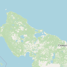
Map view of Onezhskoye Pomorye National Park

Use this park location map to pinpoint Onezhskoye Pomorye National Park in Russia, understand its exact geographic position, and read its mapped placement within the surrounding landscape more clearly.

Pigeon | © OpenStreetMap contributors

Location context for Onezhskoye Pomorye National Park

Arkhangelsk OblastOnezhsky DistrictPrimorsky District

Visualizing old-growth taiga forests and White Sea coastal habitats

Onezhskoye Pomorye National Park Photos, Landscapes, and Scenery

Examine detailed photographs of Onezhskoye Pomorye National Park to understand its remote boreal taiga forests and icy marine coastlines. Visual documentation reveals the undisturbed wilderness character and glaciated terrain defining this northern protected area.

Panoramic view of a river with autumn-colored trees, grassy hills, and dramatic clouds with sunlight breaking through

Park atlas

Compare adjacent boreal wilderness reserves and coastal northern landscapes

Explore Other Parks Near Onezhskoye Pomorye National Park and Surrounding Protected Areas

Visitors exploring Onezhskoye Pomorye National Park can continue examining nearby protected areas and boreal forest reserves. Comparing adjacent regional geography reveals broader patterns in northern European wilderness conservation.
Watercolor painting of a lake with pine-covered islands and rolling hills in the background.
National parkArkhangelsk Oblast
About 36 km away#1 closest

Northeast

Onezhskoye Pomorye National Park: An Atlas of Protected Northern Taiga and Coastal Terrains

Exploring the glacial landscapes of Arkhangelsk Oblast

Onezhskoye Pomorye National Park serves as a significant protected corridor where large tracts of old-growth spruce and pine forest extend directly to the White Sea shoreline. The mapped terrain transitions from elevated glacial plains and moraine ridges to low-lying glacio-marine terraces, dunes, and migratory wetlands. This geographic record highlights the park's role in conserving boreal wilderness, salmon-rich rivers, and the historic cultural legacy of the Pomor people along the northern coast.

Area
2,016.68 km²
Established
2013
IUCN
II
Relief
Mixed relief
Watercolor painting depicting a lake surrounded by trees and hills under a soft sky
National parkArkhangelsk Oblast
About 122 km away#2 closest

South

Vodlozersky National Park: A Protected National Park within Arkhangelsk Oblast's Geography

Explore the mapped boundaries and natural landscape of this national park.

Vodlozersky National Park serves as a significant protected landscape within the Arkhangelsk Oblast region. This national park detail page provides focused access to its geographic identity, mapped terrain, and protected area status. Utilize MoriAtlas to understand the specific context of Vodlozersky National Park and its role in the regional atlas of natural areas, enhancing your geographic discovery.

Area
4,280 km²
Established
1991
IUCN
II
Visitors
1K annual
National parkRepublic of Karelia
About 255 km away#3 closest

South

Vodlozero National Park: Geographic Profile of Russia's Pristine Taiga and Wetland Landscapes

Protected boreal ecosystems in the Republic of Karelia

Vodlozero National Park protects a significant expanse of pristine boreal forest, lake systems, and river basins in the Russian North. This entry provides a structured look at the park geography, covering its status as a biosphere reserve, its sprawling taiga terrain, and the cultural landscape that defines its remote northern boundaries.

Area
4,683 km²
Established
1991
IUCN
II
Relief
Lowland
A stylized vector illustration featuring a large, balanced boulder perched on a cliff edge, surrounded by evergreen trees and a distant mountain waterfall.
Natural monumentRepublic of Karelia
About 298 km away#4 closest

Southwest

Vottovaara National Park and Natural Monument: Mapping the West Karelian Upland

Protected quartzite massifs and glacial boulder fields in Russia

Vottovaara stands as a significant natural landmark in the Republic of Karelia, defined by its quartzite bedrock and plateau covered in glacial erratics. As a protected national park and natural monument, it represents the high-relief landscape of the West Karelian Upland, providing mapped access to a unique convergence of taiga forest and exposed geological formations.

Area
140.59 km²
Established
2023
IUCN
III
Relief
Mountain
Natural monumentRepublic of Karelia
About 298 km away#5 closest

Southwest

Mount Vottovaara Natural Monument: Explore Protected Landscape and Geographic Context in Karelia

Mapped protected area boundaries and regional terrain in the Republic of Karelia.

Mount Vottovaara represents a significant natural monument within the Republic of Karelia, offering a focal point for structured geographic exploration. This protected landscape's mapped boundaries and its setting within the region's broader geography are key to understanding its atlas value. MoriAtlas provides the framework to examine the specific identity of Mount Vottovaara as a protected area, encouraging detailed study of its natural features and regional context.

Area
15 km²
Established
2011
IUCN
III
Relief
Mixed relief
Watercolor painting showing a lake surrounded by forests with mountains in the background
National parkRussia
About 305 km away#6 closest

South

Kenozersky National Park: Geography, Glacial Landscapes, and Protected Taiga Forests in Russia

Exploring the lake-studded terrain of the Arkhangelsk Oblast

Kenozersky National Park offers a profound look at the glacial geology of northern Russia. The area encompasses an integrated network of streams, wetlands, and spruce-dominated forests, providing essential habitat and reflecting centuries of human interaction with the natural terrain.

IUCN
II
Watercolor painting of a lake landscape with islands, rolling green hills, and light atmospheric washes, featuring soft green and pale tones on a white background.
National parkArkhangelsk Oblast
About 305 km away#7 closest

South

Kenozersky National Park: Geography and Protected Heritage in Arkhangelsk Oblast

A UNESCO-listed cultural and natural landscape.

Located in the Arkhangelsk Oblast, Kenozersky National Park protects a distinctive middle taiga environment defined by ancient crustal fracture basins and significant watershed features like the Maselga esker. The area serves as a primary example of a cultural-natural landscape, merging intact boreal wilderness with the preserved architectural history of the Russian North, including traditional churches, villages, and sacred groves that have persisted for centuries.

Area
1,413.54 km²
Established
1991
IUCN
II
Relief
Upland
National parkRepublic of Karelia
About 336 km away#8 closest

West

Kalevalsky National Park: Boreal Wilderness and Protected Landscapes in the Republic of Karelia

Ancient taiga ecosystems and glacial terrain mapped.

Located near the Russian-Finnish border, Kalevalsky National Park encompasses 74,400 hectares of rare primeval boreal forest. The park offers insight into the Baltic Shield's geological history and provides a map of extensive marshlands and lake basins that define this remote Karelian region.

Area
744 km²
Established
2007
IUCN
II
Relief
Lowland

Common questions about visiting, size, designation, and location context for Onezhskoye Pomorye National Park

Onezhskoye Pomorye National Park FAQs for park facts, access, geography, and protected area context

Find quick answers about Onezhskoye Pomorye National Park, including protected-area facts, park geography, trail and visitor context, and how the park fits into its surrounding country and regional landscape.
MoriAtlas Explorer

Continue Your Protected Areas Search Across the Global Atlas

Deepen your exploration by continuing the structured search for national parks and protected areas worldwide. Utilize the comprehensive filtering capabilities to compare different conservation landscapes and refine your understanding of global park geography. Discover more about the distribution and characteristics of protected natural areas.

Global natural geography