

Mori Atlas logo
National parkRwenzori Mountains National Park

Discover the complex high altitude terrain and protected boundaries of this significant Albertine Rift ecosystem.

Rwenzori Mountains National Park: Mapping the Alpine Geography and Equatorial Glacial Landscapes

Rwenzori Mountains National Park represents a rare geographic phenomenon where equatorial proximity meets permanent glacial ice. Covering nearly 1,000 square kilometres of the Rwenzori range, this protected area spans from lush montane forest to alpine heath and snowfields. The landscape contains Africa's third, fourth, and fifth highest peaks, carving out a dramatic topography of sharp ridges, deep valleys, and glacial lakes within the Albertine Rift system.

UNESCO World Heritage SiteAlpine EnvironmentGlacial LandscapeEquatorial MountainsRamsar WetlandEndemic Species

Rwenzori Mountains National Park

National park

Park overview

Structured park overview, official facts, and landscape profile for Rwenzori Mountains National Park

Rwenzori Mountains National Park park facts, protected area profile, and essential visitor context

Review the core facts for Rwenzori Mountains National Park, including designation, size, terrain, visitor scale, habitats, and operating context in one park-focused overview.

About Rwenzori Mountains National Park

Rwenzori Mountains National Park occupies a remarkable position in Africa's protected area network as one of the continent's premier high-altitude mountain parks. Located in the Bundibugyo, Kabarole, and Kasese districts of southwestern Uganda, the park lies along the eastern side of the Albertine Rift and shares a 50-kilometre border with the Democratic Republic of the Congo's Virunga National Park, creating a transfrontier conservation complex of outstanding significance. The Rwenzori Mountains themselves rise dramatically from the surrounding dry plains, forming a massive block of crystalline uplands that exceed the elevation of the European Alps despite their proximity to the equator. This unique positioning results in a vertical span of ecosystems from tropical montane forest through successive vegetation zones to permanent ice and glaciers, a breadth of ecological variation rarely found in a single protected area. The park's establishment in 1991 formalized protection for a landscape that had attracted scientific interest since the late 19th century, when European explorers first documented the snow-capped peaks rising from the African interior. Today the park remains one of Africa's most geologically and ecologically significant mountain protected areas, drawing trekkers and researchers to experience its distinctive combination of equatorial warmth and alpine conditions.

Quick facts and research context for Rwenzori Mountains National Park

Rwenzori Mountains National Park spans approximately 998 square kilometres along the Uganda-DRC border in the Albertine Rift region. Established in 1991, the park protects a mountain range that exceeds 2,500 metres in elevation across 70 percent of its area, with the park extending 120 kilometres in length and 48 kilometres in width. The park contains three of Africa's five highest peaks and features glaciers, glacial lakes, and waterfalls within a landscape that changes dramatically across five distinct vegetation zones. It was designated a UNESCO World Heritage Site in 1994 and a Ramsar Wetland in 2009, reflecting its outstanding universal value.

Protection and recognition

Documented terrestrial protection scope and international recognition data

Rwenzori Mountains National Park Protection Status and UNESCO Recognition

Rwenzori Mountains National Park maintains a documented terrestrial protection scope backed by official UNESCO World Heritage recognition. Structured records summarize administrative designations and international recognition sources for the protected landscape.

International recognition

Protection details

Protection scope
Terrestrial
Transboundary protection
No
Park context

Deeper park guide and search-rich context for Rwenzori Mountains National Park

Rwenzori Mountains National Park history, landscape, wildlife, and travel context

Explore Rwenzori Mountains National Park through its history, landscape character, ecosystems, wildlife, conservation priorities, cultural context, and seasonal travel timing in a structured park guide built for atlas discovery and search intent.

Why Rwenzori Mountains National Park stands out

The Rwenzori Mountains are uniquely renowned for their glacial landscapes at equatorial latitudes, a geographic phenomenon that creates one of Africa's most distinctive mountain environments. The park protects Margherita Peak, Africa's third highest summit, along with a complex of glaciers and snowfields that have made the Rwenzori range famous among mountaineers and naturalists since the early 20th century. The mountain's botanical richness has been described as some of the most beautiful in the world, with five vegetation zones ranging from montane forest through bamboo zones to alpine heath and glacial ecosystems. The park also harbours significant populations of forest elephants, chimpanzees, and several primate species within its protected boundaries.

Rwenzori Mountains National Park history and protected-area timeline

Rwenzori Mountains National Park was formally established in 1991, consolidating protection for the Rwenzori Mountains that had garnered international attention for decades. The park was designated a UNESCO World Heritage Site in 1994, recognized for its outstanding natural beauty and the exceptional geological and ecological values of its glacial mountain landscape. Between 1997 and June 2001, the Rwenzori Mountains experienced occupation by rebel militias associated with the Rwenzururu movement, which created significant challenges for park management and conservation. This period of insecurity, combined with resource constraints, led to the park's inscription on UNESCO's List of World Heritage in Danger from 1999 to 2004. The designation reflected concerns about the impact of armed conflict on the park's values and the capacity of management authorities to maintain adequate protection. Following the resolution of the conflict situation, the park was removed from the danger list, though conservation challenges continue to require sustained management attention. In 2009, the park received additional recognition as a Ramsar Wetland, acknowledging the importance of its glacial and lacustrine systems within the broader wetland conservation framework.

Rwenzori Mountains National Park landscape and geographic character

The Rwenzori Mountains present one of Africa's most dramatic and distinctive mountain landscapes, characterized by massive陡峭的山峰、冰川和湖泊。公园包含三个非洲最高峰:马格里塔峰(5,109米),是非洲第三高峰;斯佩克峰(第四)和贝克峰(第五)。这些花岗岩和片麻岩山峰被冰川雕刻成尖锐的山脊和山谷,冰川从高山区域向下延伸,形成独特的寒冷环境。尽管位于赤道附近,由于高海拔,这些山脉仍然被冰雪覆盖,这是在非洲赤道地区罕见的地质现象。公园的景观包括瀑布、深谷和冰川湖泊,其地理特征在非洲高山环境中独具特色。

Rwenzori Mountains National Park ecosystems, habitats, and plant life

The Rwenzori Mountains support an extraordinary range of habitats across five distinct vegetation zones that change with altitude. The montane forest zone gives way to bamboo forest, then heath and grassland, before reaching the alpine zone and finally the glacial zone. This vertical zonation creates remarkable botanical diversity, with the park's flora described as among the most beautiful in the world. The Albertine Rift location means many species found here are endemic to this region, adding significant conservation value to the park's ecological portfolio. The combination of high rainfall, persistent mist, and varied elevation creates conditions suitable for lush vegetation growth, with mosses, ferns, and epiphytic plants carpeting the forest and adding to the mountain's reputation for exceptional botanical richness.

Rwenzori Mountains National Park wildlife and species highlights

Rwenzori Mountains National Park supports diverse wildlife populations that vary with elevation and habitat zone. The park records 89 bird species, 15 butterfly species, and four primate species, alongside larger mammals including forest elephants and chimpanzees. Notable primate species include the Angola colobus and L'Hoest's monkey, while the park also harbours the Rwenzori duiker, a species adapted to the mountain's forest and heath environments. The Rwenzori turaco, a distinctive bird species, takes its name from these mountains and represents one of the park's notable avifauna. Wildlife observation opportunities vary with elevation, with different species encountered across the park's various vegetation zones as trekkers ascend from the forests to the alpine areas.

Rwenzori Mountains National Park conservation status and protection priorities

The Rwenzori Mountains National Park holds multiple international designations that reflect its exceptional conservation significance. As a UNESCO World Heritage Site, it is recognized for outstanding universal value in terms of natural beauty and the geologically significant glacial landscape of Africa's highest mountains. Its Ramsar Wetland designation acknowledges the importance of glacial meltwater systems, lakes, and wetland habitats within the protected area. The park's location within the Albertine Rift, one of Africa's most biodiverse regions, adds further conservation importance, with numerous endemic species requiring protection. Conservation challenges include managing the interface between protected mountain ecosystems and surrounding human landscapes, while maintaining the ecological integrity of this significant transfrontier protected area.

Rwenzori Mountains National Park cultural meaning and human context

The Rwenzori Mountains hold deep cultural significance for local communities in southwestern Uganda. The mountains, known locally with names reflecting indigenous knowledge systems, have been home to communities whose relationship with this landscape spans generations. Traditional land use practices and cultural associations with specific mountain features reflect the long history of human presence in this highland area. The park's gateway town of Kasese serves as the primary access point for visitors, with local communities involved in tourism and conservation activities that connect park management with regional development priorities.

Top sights and standout views in Rwenzori Mountains National Park

Rwenzori Mountains National Park offers trekking and climbing experiences that are unique in Africa, with the famous seven-day circuit providing access to the park's most spectacular landscapes and viewpoints. The combination of equatorial location and high-altitude glacial environments creates a trekking experience unlike any other on the continent, where visitors can walk from tropical forest through bamboo zones to alpine heath and glacier ice within a single journey. The park's biodiversity, including endemic species and distinctive high-altitude wildlife, provides exceptional opportunities for nature observation, while the cultural significance of the mountains adds depth to the visitor experience. The transfrontier relationship with Virunga National Park creates one of Africa's most significant mountain conservation complexes.

Best time to visit Rwenzori Mountains National Park

The Rwenzori Mountains can be visited throughout the year, though conditions vary with seasons. The mountain environment is influenced by equatorial weather patterns, with wet and dry seasons affecting trail conditions and visibility. The dry seasons typically offer more stable conditions for trekking, though the Rwenzori's high-altitude environment can experience rainfall in any season. Visitors planning multi-day treks should consider the seasonal patterns that affect the difficulty and enjoyment of high-altitude hiking in this equatorial mountain environment.

Monthly climate preview

Long-term representative point measurements tracking monthly temperature and precipitation variation

Rwenzori Mountains National Park Climate Normals and Annual Weather Rhythm

Representative coordinates record steady monthly mean temperatures alongside shifting precipitation rates across the twelve-month cycle. Examining the complete monthly climate profile reveals detailed thermal ranges and multi-season precipitation shifts for this protected Ugandan landscape.
Annual mean20 °C
20 °C21 °C
Jan21°
Feb21°
Mar21°
Apr20°
May20°
Jun20°
Jul20°
Aug20°
Sep20°
Oct20°
Nov20°
Dec20°
Warmest month
February

21.4 °C

Coolest month
November

19.6 °C

Wettest month
November

5.5 mm/day

Driest month
January

2.3 mm/day

Park location guide

Geography guide, regional context, and park location map for Rwenzori Mountains National Park

Rwenzori Mountains National Park park geography, regions, and map view in Uganda

Understand where Rwenzori Mountains National Park sits in Uganda through a broader geographic reading of the surrounding landscape, nearby location context, and its mapped position within the national park landscape.

How Rwenzori Mountains National Park fits into Uganda

Uganda is a landlocked East African nation spanning approximately 241,000 km². It borders five countries and contains part of Lake Victoria, the world's second-largest freshwater lake. The country operates as a presidential republic with Kampala as its capital and largest city.

Wider geography shaping Rwenzori Mountains National Park in Uganda

Uganda is situated in East Africa, bordered by Kenya to the east, South Sudan to the north, the Democratic Republic of the Congo to the west, Rwanda to the southwest, and Tanzania to the south. The southern portion includes a substantial part of Lake Victoria. The terrain features volcanic hills, mountains, and lakes.

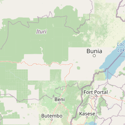
Map view of Rwenzori Mountains National Park

Use this park location map to pinpoint Rwenzori Mountains National Park in Uganda, understand its exact geographic position, and read its mapped placement within the surrounding landscape more clearly.

Pigeon | © OpenStreetMap contributors

Location context for Rwenzori Mountains National Park

Bundibugyo DistrictKabarole DistrictKasese District
Park atlas

Compare regional alpine terrain and connected Albertine Rift protected landscapes

Parks Near Rwenzori Mountains National Park and Surrounding Protected Areas

Browsing nearby national parks and protected areas provides deeper context for the unique equatorial glacial ecosystems surrounding Rwenzori Mountains National Park. Expanding geographic comparison across regional mountain terrain helps trace broader conservation networks and alpine geography.
National parkUganda
About 2.6 km away#1 closest

Southwest

Rwenzori Mountains National Park: A Study of Glacial Terrain and Afro-alpine Ecosystems

Explore the mountainous geography of Uganda and its protected high-altitude landscapes.

Defined by massive massifs and retreating glaciers, Rwenzori Mountains National Park features a rare vertical landscape that anchors the geography of western Uganda. Trace the boundaries of this protected area to understand its unique role in supporting biodiversity across distinct vegetation zones, from lowland montane forests to snow-capped summits.

Area
996 km²
Established
1991
IUCN
VI
Relief
Mountain
Watercolor illustration of rolling hills, mountains, and a river or lake
National parkDemocratic Republic of the Congo
About 5.9 km away#2 closest

Southwest

Virunga National Park: Democratic Republic of the Congo's Premier Protected Landscape

Mapped boundaries and diverse Albertine Rift endemic geography.

Virunga National Park represents a pivotal protected area within the Democratic Republic of the Congo, characterized by an exceptional range of geographic features and vital ecosystems. Its protected landscape includes active volcanoes like Nyiragongo with its lava lake, the towering Rwenzori Mountains, and diverse lowland savannas. This atlas-focused entry highlights the park's unique position in the Albertine Rift, crucial for numerous endemic species and offering significant insight into regional geography and protected land context.

Area
7,800 km²
Established
1925
IUCN
II
Relief
Mountain
National parkUganda
About 49 km away#3 closest

North

Semuliki National Park: Protected Lowland Rainforest Geography and Atlas Data

A mapped tropical valley wilderness in western Uganda

Semuliki National Park stands as a significant protected lowland rainforest in Uganda, characterized by a flat, humid valley floor and dense forest corridors along the Semuliki River. This area serves as a rare example of Central African ecological communities preserved within an East African landscape, offering extensive data on its unique vegetation patterns and riparian zones.

National parkBundibugyo District
About 49 km away#4 closest

North

Semuliki National Park: Protected Lowland Forest and Geothermal Landscapes in Bundibugyo

Geographic atlas of the Albertine Rift lowland rainforests

Semuliki National Park stands as a singular protected landscape featuring East Africa's most significant lowland tropical rainforest. Situated in the remote Bundibugyo District, the park maps a transition of ecosystems from the dense forest floors to the geothermal mineral pools of the Sempaya area. This protected zone provides a essential study of lowland geography and species biodiversity within the broader context of the Western Uganda rift valley floor.

Area
219 km²
Established
1993
IUCN
II
Relief
Lowland
National parkUganda
About 51 km away#5 closest

East

Kibale National Park: National Park Atlas and Protected Landscape in Uganda

Explore mapped boundaries and regional geographic context.

Kibale National Park represents a key protected landscape within Uganda, identified by its national park designation. This entity offers a focused lens for understanding regional geography and the distribution of protected areas across East Africa. Delve into the mapped boundaries and specific landscape character that define Kibale National Park, providing a concrete point of reference for atlas exploration and geographic discovery.

Area
776 km²
Established
1993
IUCN
II
Relief
Mixed relief
National parkUganda
About 60 km away#6 closest

South

Queen Elizabeth National Park: Mapped Protected Landscape in Uganda's Geography

Explore Uganda's National Park map and terrain.

Queen Elizabeth National Park represents a significant protected landscape within Uganda, offering a rich context for geographic exploration. As a national park, its mapped boundaries define a unique area for understanding the region's natural terrain and landscape character. This destination provides structured data essential for atlas-based discovery, allowing users to analyze its geographic positioning and its role within Uganda's conservation areas.

Area
1,978 km²
Established
1952
IUCN
II
Relief
Mixed relief
National parkKanungu District
About 144 km away#7 closest

South

Bwindi Impenetrable National Park: Uganda's National Park Geography and Mapped Terrain

Explore its protected landscape and regional context.

Delve into the protected landscape of Bwindi Impenetrable National Park, a protected area situated within Kanungu District, Uganda. This detail page offers a deep dive into its geographic setting, presenting mapped park boundaries and natural terrain features essential for understanding its role within the regional atlas. Discover the specific environmental context of this national park for robust map-based exploration.

Area
331 km²
Established
1991
IUCN
II
Relief
Mountain
National parkDemocratic Republic of the Congo
About 159 km away#8 closest

West

Maiko National Park National Park: Map and Protected Landscape Exploration

Discover primary forest terrain and endemic species sanctuary.

Maiko National Park, situated in the Democratic Republic of the Congo, is a cornerstone of central African conservation, protecting over 10,000 square kilometers of pristine tropical rainforest. This national park is recognized globally for its critical role in harboring endemic species such as Grauer's gorilla and the okapi, alongside significant populations of forest elephants and chimpanzees. Its extensive river systems and varied terrain within the Ituri Rainforest ecosystem provide essential habitat, establishing Maiko as a key area for understanding and preserving central African biodiversity and landscape context.

Area
10,885 km²
Established
1970
IUCN
II
Relief
Mixed relief

Common questions about visiting, size, designation, and location context for Rwenzori Mountains National Park

Rwenzori Mountains National Park FAQs for park facts, access, geography, and protected area context

Find quick answers about Rwenzori Mountains National Park, including protected-area facts, park geography, trail and visitor context, and how the park fits into its surrounding country and regional landscape.
MoriAtlas Explorer

Continue Your Protected Areas Search Across the Global Atlas

Deepen your exploration by continuing the structured search for national parks and protected areas worldwide. Utilize the comprehensive filtering capabilities to compare different conservation landscapes and refine your understanding of global park geography. Discover more about the distribution and characteristics of protected natural areas.

Global natural geography
