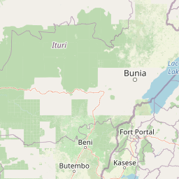
Why Semuliki National Park stands out
Semuliki National Park is renowned as the only significant lowland tropical rainforest in East Africa, making it a critical stronghold for Congo Basin species at the eastern limit of their range. The park is exceptionally rich in birdlife, with over 400 species recorded including nine hornbill species and forest specialists such as Oberländer's ground thrush and Sassi's olive greenbul. Its butterfly diversity is extraordinary, with nearly 460 species documented. The Sempaya hot springs provide a unique geological feature, with the Mumbuga spring forming a half-meter high fountain that attracts shorebirds and serves as a salt lick for mammals.
Semuliki National Park history and protected-area timeline
The area now comprising Semuliki National Park was first protected in 1932 when the British colonial administration designated it as a forest reserve, placing it under the management of the Forest Department. This designation reflected recognition of the forest's ecological value and its importance to local communities. Following Uganda's independence in 1962, management of the forest reserve transitioned to the Ugandan government's Forest Department, which continued overseeing the area through periods of political instability and economic change. In October 1993, the Ugandan government elevated the reserve to national park status, creating Semuliki National Park as part of a broader expansion of Uganda's protected area network. This designation aimed to provide stronger legal protection for the forest ecosystem while integrating the area into the country's wildlife tourism sector. The transition from forest reserve to national park brought increased focus on wildlife conservation and visitor management, though the park has faced challenges from civil unrest in the late 1990s and ongoing pressure from surrounding communities.
Semuliki National Park landscape and geographic character
The topography of Semuliki National Park consists of flat to gently undulating terrain at relatively low elevation for Uganda, ranging from 670 to 760 meters above sea level. This lowland character distinguishes the park from the surrounding Ruwenzori Mountains and other western Ugandan protected areas. The landscape is characterized by dense rainforest canopy interrupted by river corridors where the Semliki River and Lamia Rivers flow through the park, creating important watering sites for wildlife. The park contains two notable hot springs, the Sempaya Hot Springs, where geothermally heated water emerges from the ground in a mineral-encrusted swamp area. The Mumbuga spring exhibits geyser-like behavior, periodically projecting water half a meter into the air. During the wet seasons, extensive flooding occurs across low-lying areas, creating seasonal wetlands that support specialized wildlife communities. The gentle relief and extensive forest cover create a mysterious, enclosed landscape where visibility is often limited to short distances beneath the canopy.
Semuliki National Park ecosystems, habitats, and plant life
The ecological character of Semuliki National Park is defined by its lowland tropical rainforest, which represents the only significant example of this habitat type in East Africa. The vegetation consists primarily of medium altitude moist evergreen to semi-deciduous forest, with the Uganda ironwood (Cynometra alexandri) serving as the dominant tree species. The forest contains communities of more purely evergreen trees and distinctive swamp forest formations in riparian zones and seasonally flooded areas. This habitat complexity supports extraordinary biodiversity, with the park serving as the eastern limit for many Congo Basin species that reach their range boundary here. The location at the intersection of multiple ecoregions and climate zones creates exceptional microhabitat diversity, supporting species assemblages that blend East African and Central African elements. The park's biodiversity significance is magnified by its position within the Albertine Rift, recognized as one of Africa's most important centers of endemism.
Semuliki National Park wildlife and species highlights
Semuliki National Park supports remarkable faunal diversity, with over 60 mammal species, more than 400 bird species, and nearly 460 butterfly species documented within its boundaries. The bird community is especially notable, with 216 species classified as true forest birds, representing 66 percent of Uganda's total forest bird fauna. Nine hornbill species occur in the park, an extraordinary concentration for a single protected area. The mammal community includes eight primate species, with the Mona monkey commonly observed in the forest canopy. The park supports nine duiker species, including the bay duiker, making it a significant stronghold for this antelope group. Other notable mammals include African buffalo, leopard, hippopotamus, African elephant, water chevrotain, African civet, and the rare Pygmy scaly-tailed flying squirrel. The butterfly diversity ranks among the highest in Africa, with nearly 460 species recorded. The hot springs provide important habitat for shorebirds and create mineral-rich areas that serve as natural salt licks attracting numerous mammal species.
Semuliki National Park conservation status and protection priorities
Semuliki National Park holds exceptional conservation significance as the only substantial lowland tropical rainforest in East Africa and one of the richest biodiversity areas on the continent. The park protects critical habitat for species at the eastern edge of their distributions, serving as a biogeographical bridge between Central African and East African faunal communities. Its designation as a national park provides legal protection for an ecosystem that would otherwise face significant deforestation pressure from the surrounding population. The park forms part of a network of protected areas within the Albertine Rift, a region recognized globally for its concentration of endemic species. Conservation challenges include pressure from the growing local population, historical conflict that disrupted management activities, and the need to balance protection with the legitimate livelihood needs of surrounding communities. The Uganda Wildlife Authority has increasingly emphasized community-based conservation approaches since the 1990s, involving local populations in park planning and providing alternative income opportunities through tourism.
Semuliki National Park cultural meaning and human context
The forests of Semuliki National Park hold profound importance for the local human communities who have lived in proximity to this landscape for generations. Approximately 100 Great Lakes Twa people, an indigenous pygmy community, reside within the park boundaries, maintaining traditional hunter-gatherer lifestyles that connect them intimately to the forest ecosystem. The park provides important cultural and spiritual value to these communities, alongside the practical resources they extract including fruits, vegetables, herbal medicines, and construction materials. The broader population surrounding the park practices subsistence agriculture and depends heavily on forest resources, with population growth rates of 3.4 percent annually creating increasing pressure on park resources. Community relations with park management have evolved significantly since the 1990s, moving from exclusionary practices that generated resentment toward more collaborative approaches that involve local communities in conservation planning. The Basua people, as the local Twa community is known, now receive income from tourism activities and share their cultural traditions with visitors through demonstrations of traditional crafts.
Top sights and standout views in Semuliki National Park
Semuliki National Park offers visitors the rare opportunity to experience East Africa's only lowland tropical rainforest, a habitat type found nowhere else in the region. The Sempaya Hot Springs provide a unique geothermal feature where visitors can observe mineral-encrusted pools and the periodic fountain of the Mumbuga spring. The exceptional bird diversity, particularly the nine hornbill species and specialist forest birds like Oberländer's ground thrush, makes the park a premier destination for ornithologists. The possibility of spotting Central African species at their eastern range limit, including various duikers and the Pygmy scaly-tailed flying squirrel, adds special allure for wildlife enthusiasts. The cultural presence of the Great Lakes Twa people offers visitors insights into indigenous forest-based lifeways that have persisted for generations.
Best time to visit Semuliki National Park
Semuliki National Park can be visited throughout the year, though the wet seasons from March to May and September to December bring extensive flooding that can limit access to some areas and make certain trails difficult to navigate. The dry seasons, while still experiencing some rainfall, generally offer better conditions for wildlife viewing and park exploration. The hot springs remain accessible year-round. The park's equatorial location means temperatures remain consistently warm, ranging from 18 to 30 degrees Celsius, regardless of season. Visitors seeking optimal wildlife viewing conditions may prefer the drier periods, though the wet seasons bring the forest to life with blooming flowers and active animal behavior. The hot springs are particularly atmospheric during cooler periods when steam is more visible.