

Mori Atlas logo
National parkSemuliki National Park

Mapping the ecological boundaries and unique valley geography of Western Uganda

Semuliki National Park: An Atlas of Protected Lowland Rainforests and Geothermal Terrain

Semuliki National Park represents a rare lowland tropical rainforest enclave situated within the Albertine Rift ecosystem of Bundibugyo District. This protected area acts as a vital transition zone between the Congo Basin and the higher altitude landscapes of Western Uganda. The mapped terrain encompasses flat to undulating floodplains, dense canopy forest corridors, and active mineral-encrusted geothermal hot springs. Geographic analysis reveals how this remote protected zone supports species distributions at their extreme eastern range limits, distinct from the surrounding mountain topography.

lowland tropical rainforestAlbertine RiftUganda national parksbirdwatchingforest ecosystemhot springs

Semuliki National Park

National park

Park overview

Structured park overview, official facts, and landscape profile for Semuliki National Park

Semuliki National Park park facts, protected area profile, and essential visitor context

Review the core facts for Semuliki National Park, including designation, size, terrain, visitor scale, habitats, and operating context in one park-focused overview.

About Semuliki National Park

Semuliki National Park represents one of Africa's most significant biodiversity repositories, protecting a rare tract of lowland tropical rainforest in an otherwise mountainous region of eastern Uganda. The park's remote location in Bwanna County of Bundibugyo District has helped preserve its ecological integrity, though the surrounding area faces increasing human pressure from a growing local population dependent on forest resources. The park forms part of the larger Albertine Rift ecosystem, which spans the western arm of the East African Rift and contains exceptional concentrations of endemic species. Unlike the montane forests common throughout Uganda's protected areas, Semuliki's lowland character supports species more typical of central African rainforests, creating a unique biogeographical interface where Congo Basin fauna reaches its eastern distributional limits. The Uganda Wildlife Authority manages the park with increasing emphasis on community involvement, recognizing that long-term conservation success depends on addressing the livelihood needs of neighboring populations who have historically relied on forest products.

Quick facts and research context for Semuliki National Park

Semuliki National Park protects East Africa's sole remaining significant lowland tropical rainforest, spanning 219 square kilometers along the Uganda-Democratic Republic of the Congo border in the Western Region of Uganda. The park lies within the Albertine Rift, a biodiversity hotspot, at elevations between 670 and 760 meters above sea level. Annual rainfall averages 1,250 millimeters with distinct wet seasons from March to May and September to December, when extensive flooding occurs across many areas. The park features two notable hot springs, the Sempaya Hot Springs, which create unique mineral-encrusted swamp habitats and attract diverse wildlife. Temperature ranges from 18 to 30 degrees Celsius year-round.

Protection and recognition

Examine the terrestrial conservation scope and official designation records

Semuliki National Park Protection Status and International Recognition Data

Semuliki National Park maintains a documented terrestrial protection status within official conservation frameworks. Official records assemble baseline management scope and designated governance details for comprehensive geographic analysis.

Protection details

Protection scope
Terrestrial
Transboundary protection
No
Park context

Deeper park guide and search-rich context for Semuliki National Park

Semuliki National Park history, landscape, wildlife, and travel context

Explore Semuliki National Park through its history, landscape character, ecosystems, wildlife, conservation priorities, cultural context, and seasonal travel timing in a structured park guide built for atlas discovery and search intent.

Why Semuliki National Park stands out

Semuliki National Park is renowned as the only significant lowland tropical rainforest in East Africa, making it a critical stronghold for Congo Basin species at the eastern limit of their range. The park is exceptionally rich in birdlife, with over 400 species recorded including nine hornbill species and forest specialists such as Oberländer's ground thrush and Sassi's olive greenbul. Its butterfly diversity is extraordinary, with nearly 460 species documented. The Sempaya hot springs provide a unique geological feature, with the Mumbuga spring forming a half-meter high fountain that attracts shorebirds and serves as a salt lick for mammals.

Semuliki National Park history and protected-area timeline

The area now comprising Semuliki National Park was first protected in 1932 when the British colonial administration designated it as a forest reserve, placing it under the management of the Forest Department. This designation reflected recognition of the forest's ecological value and its importance to local communities. Following Uganda's independence in 1962, management of the forest reserve transitioned to the Ugandan government's Forest Department, which continued overseeing the area through periods of political instability and economic change. In October 1993, the Ugandan government elevated the reserve to national park status, creating Semuliki National Park as part of a broader expansion of Uganda's protected area network. This designation aimed to provide stronger legal protection for the forest ecosystem while integrating the area into the country's wildlife tourism sector. The transition from forest reserve to national park brought increased focus on wildlife conservation and visitor management, though the park has faced challenges from civil unrest in the late 1990s and ongoing pressure from surrounding communities.

Semuliki National Park landscape and geographic character

The topography of Semuliki National Park consists of flat to gently undulating terrain at relatively low elevation for Uganda, ranging from 670 to 760 meters above sea level. This lowland character distinguishes the park from the surrounding Ruwenzori Mountains and other western Ugandan protected areas. The landscape is characterized by dense rainforest canopy interrupted by river corridors where the Semliki River and Lamia Rivers flow through the park, creating important watering sites for wildlife. The park contains two notable hot springs, the Sempaya Hot Springs, where geothermally heated water emerges from the ground in a mineral-encrusted swamp area. The Mumbuga spring exhibits geyser-like behavior, periodically projecting water half a meter into the air. During the wet seasons, extensive flooding occurs across low-lying areas, creating seasonal wetlands that support specialized wildlife communities. The gentle relief and extensive forest cover create a mysterious, enclosed landscape where visibility is often limited to short distances beneath the canopy.

Semuliki National Park ecosystems, habitats, and plant life

The ecological character of Semuliki National Park is defined by its lowland tropical rainforest, which represents the only significant example of this habitat type in East Africa. The vegetation consists primarily of medium altitude moist evergreen to semi-deciduous forest, with the Uganda ironwood (Cynometra alexandri) serving as the dominant tree species. The forest contains communities of more purely evergreen trees and distinctive swamp forest formations in riparian zones and seasonally flooded areas. This habitat complexity supports extraordinary biodiversity, with the park serving as the eastern limit for many Congo Basin species that reach their range boundary here. The location at the intersection of multiple ecoregions and climate zones creates exceptional microhabitat diversity, supporting species assemblages that blend East African and Central African elements. The park's biodiversity significance is magnified by its position within the Albertine Rift, recognized as one of Africa's most important centers of endemism.

Semuliki National Park wildlife and species highlights

Semuliki National Park supports remarkable faunal diversity, with over 60 mammal species, more than 400 bird species, and nearly 460 butterfly species documented within its boundaries. The bird community is especially notable, with 216 species classified as true forest birds, representing 66 percent of Uganda's total forest bird fauna. Nine hornbill species occur in the park, an extraordinary concentration for a single protected area. The mammal community includes eight primate species, with the Mona monkey commonly observed in the forest canopy. The park supports nine duiker species, including the bay duiker, making it a significant stronghold for this antelope group. Other notable mammals include African buffalo, leopard, hippopotamus, African elephant, water chevrotain, African civet, and the rare Pygmy scaly-tailed flying squirrel. The butterfly diversity ranks among the highest in Africa, with nearly 460 species recorded. The hot springs provide important habitat for shorebirds and create mineral-rich areas that serve as natural salt licks attracting numerous mammal species.

Semuliki National Park conservation status and protection priorities

Semuliki National Park holds exceptional conservation significance as the only substantial lowland tropical rainforest in East Africa and one of the richest biodiversity areas on the continent. The park protects critical habitat for species at the eastern edge of their distributions, serving as a biogeographical bridge between Central African and East African faunal communities. Its designation as a national park provides legal protection for an ecosystem that would otherwise face significant deforestation pressure from the surrounding population. The park forms part of a network of protected areas within the Albertine Rift, a region recognized globally for its concentration of endemic species. Conservation challenges include pressure from the growing local population, historical conflict that disrupted management activities, and the need to balance protection with the legitimate livelihood needs of surrounding communities. The Uganda Wildlife Authority has increasingly emphasized community-based conservation approaches since the 1990s, involving local populations in park planning and providing alternative income opportunities through tourism.

Semuliki National Park cultural meaning and human context

The forests of Semuliki National Park hold profound importance for the local human communities who have lived in proximity to this landscape for generations. Approximately 100 Great Lakes Twa people, an indigenous pygmy community, reside within the park boundaries, maintaining traditional hunter-gatherer lifestyles that connect them intimately to the forest ecosystem. The park provides important cultural and spiritual value to these communities, alongside the practical resources they extract including fruits, vegetables, herbal medicines, and construction materials. The broader population surrounding the park practices subsistence agriculture and depends heavily on forest resources, with population growth rates of 3.4 percent annually creating increasing pressure on park resources. Community relations with park management have evolved significantly since the 1990s, moving from exclusionary practices that generated resentment toward more collaborative approaches that involve local communities in conservation planning. The Basua people, as the local Twa community is known, now receive income from tourism activities and share their cultural traditions with visitors through demonstrations of traditional crafts.

Top sights and standout views in Semuliki National Park

Semuliki National Park offers visitors the rare opportunity to experience East Africa's only lowland tropical rainforest, a habitat type found nowhere else in the region. The Sempaya Hot Springs provide a unique geothermal feature where visitors can observe mineral-encrusted pools and the periodic fountain of the Mumbuga spring. The exceptional bird diversity, particularly the nine hornbill species and specialist forest birds like Oberländer's ground thrush, makes the park a premier destination for ornithologists. The possibility of spotting Central African species at their eastern range limit, including various duikers and the Pygmy scaly-tailed flying squirrel, adds special allure for wildlife enthusiasts. The cultural presence of the Great Lakes Twa people offers visitors insights into indigenous forest-based lifeways that have persisted for generations.

Best time to visit Semuliki National Park

Semuliki National Park can be visited throughout the year, though the wet seasons from March to May and September to December bring extensive flooding that can limit access to some areas and make certain trails difficult to navigate. The dry seasons, while still experiencing some rainfall, generally offer better conditions for wildlife viewing and park exploration. The hot springs remain accessible year-round. The park's equatorial location means temperatures remain consistently warm, ranging from 18 to 30 degrees Celsius, regardless of season. Visitors seeking optimal wildlife viewing conditions may prefer the drier periods, though the wet seasons bring the forest to life with blooming flowers and active animal behavior. The hot springs are particularly atmospheric during cooler periods when steam is more visible.

Monthly climate preview

Long term monthly temperature and precipitation averages recorded at representative elevation

Semuliki National Park Climate Normals, Annual Temperature and Precipitation Rhythm

Historical data compiled from NASA Power reveals average monthly temperatures ranging from 22.14 °C to 24.83 °C alongside shifting precipitation patterns across the representative coordinate. Exploring the complete twelve month profile provides detailed metrics on long term climate normals for Semuliki National Park.
Annual mean23 °C
22 °C25 °C
Jan24°
Feb25°
Mar24°
Apr23°
May23°
Jun23°
Jul23°
Aug23°
Sep23°
Oct22°
Nov22°
Dec23°
Warmest month
February

24.8 °C

Coolest month
November

22.1 °C

Wettest month
October

4.9 mm/day

Driest month
January

1.9 mm/day

Park location guide

Geography guide, regional context, and park location map for Semuliki National Park

Semuliki National Park park geography, regions, and map view in Uganda

Understand where Semuliki National Park sits in Uganda through a broader geographic reading of the surrounding landscape, nearby location context, and its mapped position within the national park landscape.

How Semuliki National Park fits into Uganda

Uganda is a landlocked East African nation spanning approximately 241,000 km². It borders five countries and contains part of Lake Victoria, the world's second-largest freshwater lake. The country operates as a presidential republic with Kampala as its capital and largest city.

Wider geography shaping Semuliki National Park in Uganda

Uganda is situated in East Africa, bordered by Kenya to the east, South Sudan to the north, the Democratic Republic of the Congo to the west, Rwanda to the southwest, and Tanzania to the south. The southern portion includes a substantial part of Lake Victoria. The terrain features volcanic hills, mountains, and lakes.

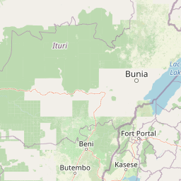
Map view of Semuliki National Park

Use this park location map to pinpoint Semuliki National Park in Uganda, understand its exact geographic position, and read its mapped placement within the surrounding landscape more clearly.

Pigeon | © OpenStreetMap contributors

Location context for Semuliki National Park

Bundibugyo District
Park atlas

Compare adjacent Albertine Rift reserves and regional forest ecosystems

Parks Near Semuliki National Park: Exploring Surrounding Protected Areas

Browsing other protected areas near Semuliki National Park reveals connected regional landscapes and diverse tropical habitats across the western border. Extending the geographical comparison helps map neighboring wildlife reserves and understand broader ecological boundaries within the Albertine Rift.
National parkUganda
Mapped park locations coincide#1 closest

Semuliki National Park: Protected Lowland Rainforest Geography and Atlas Data

A mapped tropical valley wilderness in western Uganda

Semuliki National Park stands as a significant protected lowland rainforest in Uganda, characterized by a flat, humid valley floor and dense forest corridors along the Semuliki River. This area serves as a rare example of Central African ecological communities preserved within an East African landscape, offering extensive data on its unique vegetation patterns and riparian zones.

Watercolor illustration of rolling hills, mountains, and a river or lake
National parkDemocratic Republic of the Congo
About 6.8 km away#2 closest

Southwest

Virunga National Park: Democratic Republic of the Congo's Premier Protected Landscape

Mapped boundaries and diverse Albertine Rift endemic geography.

Virunga National Park represents a pivotal protected area within the Democratic Republic of the Congo, characterized by an exceptional range of geographic features and vital ecosystems. Its protected landscape includes active volcanoes like Nyiragongo with its lava lake, the towering Rwenzori Mountains, and diverse lowland savannas. This atlas-focused entry highlights the park's unique position in the Albertine Rift, crucial for numerous endemic species and offering significant insight into regional geography and protected land context.

Area
7,800 km²
Established
1925
IUCN
II
Relief
Mountain
National parkUganda
About 49 km away#3 closest

South

Rwenzori Mountains National Park: Alpine Geography and Protected Equatorial Mountain Landscapes

Mapped terrain, glacial landscapes, and high altitude ecosystems in southwestern Uganda.

Rwenzori Mountains National Park protects a spectacular high altitude environment rising abruptly from the African rift valley. The park contains Africa's third highest summit, Margherita Peak, and features a unique array of glacial environments, waterfalls, and lakes. Its five distinct vegetation zones host significant biodiversity and endemic species within a critical transfrontier conservation complex.

Area
998 km²
Established
1991
IUCN
II
Relief
Mountain
National parkUganda
About 51 km away#4 closest

South

Rwenzori Mountains National Park: A Study of Glacial Terrain and Afro-alpine Ecosystems

Explore the mountainous geography of Uganda and its protected high-altitude landscapes.

Defined by massive massifs and retreating glaciers, Rwenzori Mountains National Park features a rare vertical landscape that anchors the geography of western Uganda. Trace the boundaries of this protected area to understand its unique role in supporting biodiversity across distinct vegetation zones, from lowland montane forests to snow-capped summits.

Area
996 km²
Established
1991
IUCN
VI
Relief
Mountain
National parkUganda
About 52 km away#5 closest

Southeast

Kibale National Park: National Park Atlas and Protected Landscape in Uganda

Explore mapped boundaries and regional geographic context.

Kibale National Park represents a key protected landscape within Uganda, identified by its national park designation. This entity offers a focused lens for understanding regional geography and the distribution of protected areas across East Africa. Delve into the mapped boundaries and specific landscape character that define Kibale National Park, providing a concrete point of reference for atlas exploration and geographic discovery.

Area
776 km²
Established
1993
IUCN
II
Relief
Mixed relief
National parkUganda
About 106 km away#6 closest

South

Queen Elizabeth National Park: Mapped Protected Landscape in Uganda's Geography

Explore Uganda's National Park map and terrain.

Queen Elizabeth National Park represents a significant protected landscape within Uganda, offering a rich context for geographic exploration. As a national park, its mapped boundaries define a unique area for understanding the region's natural terrain and landscape character. This destination provides structured data essential for atlas-based discovery, allowing users to analyze its geographic positioning and its role within Uganda's conservation areas.

Area
1,978 km²
Established
1952
IUCN
II
Relief
Mixed relief
National parkDemocratic Republic of the Congo
About 186 km away#7 closest

Southwest

Maiko National Park National Park: Map and Protected Landscape Exploration

Discover primary forest terrain and endemic species sanctuary.

Maiko National Park, situated in the Democratic Republic of the Congo, is a cornerstone of central African conservation, protecting over 10,000 square kilometers of pristine tropical rainforest. This national park is recognized globally for its critical role in harboring endemic species such as Grauer's gorilla and the okapi, alongside significant populations of forest elephants and chimpanzees. Its extensive river systems and varied terrain within the Ituri Rainforest ecosystem provide essential habitat, establishing Maiko as a key area for understanding and preserving central African biodiversity and landscape context.

Area
10,885 km²
Established
1970
IUCN
II
Relief
Mixed relief
National parkKiruhura District
About 190 km away#8 closest

Southeast

Lake Mburo National Park: Uganda's National Park in Kiruhura District

Explore its mapped boundaries and regional geography.

Delve into the protected landscape of Lake Mburo National Park, situated in Uganda's Kiruhura District. This entry provides essential geographic context, mapping its boundaries and regional setting for users interested in detailed atlas exploration of protected areas and natural landscapes.

Area
260 km²
Established
1983
IUCN
II
Relief
Lowland

Common questions about visiting, size, designation, and location context for Semuliki National Park

Semuliki National Park FAQs for park facts, access, geography, and protected area context

Find quick answers about Semuliki National Park, including protected-area facts, park geography, trail and visitor context, and how the park fits into its surrounding country and regional landscape.
MoriAtlas Explorer

Continue Your Protected Areas Search Across the Global Atlas

Deepen your exploration by continuing the structured search for national parks and protected areas worldwide. Utilize the comprehensive filtering capabilities to compare different conservation landscapes and refine your understanding of global park geography. Discover more about the distribution and characteristics of protected natural areas.

Global natural geography
