
Waterfalls
Park geography
A structured examination of park terrain, water features, and regional geography
Serpentine National Park: Comprehensive Geographic Profile and Mapped Landscape Boundaries
This geographic profile details the physical parameters of Serpentine National Park located within Western Australia. Review structured data including total area, mapped boundary spans, and the distribution of natural landscape features like cliffs, woodlands, and the Serpentine River system.
Related tags
WaterfallJarrah ForestWildflower DisplayWestern AustraliaDarling Range
Darling Range waterfall park with jarrah forests and spring wildflower displays
Serpentine National Park
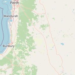
Serpentine National Park is a protected area located on the Darling Scarp approximately 55 kilometres southeast of Perth in Western Australia. The park encompasses 43.87 square kilometres of undulating upland terrain where the Serpentine River descends through a series of prominent waterfalls. Established in 1957, the park is governed by the Western Australia Department of Parks and Wildlife and represents one of the closest national parks to the Perth metropolitan area. The park's defining feature is Serpentine Falls, a cascading waterfall system that has drawn visitors for decades and serves as the primary recreational attraction within the reserve. Beyond the falls, the park includes the Serpentine Dam and smaller Pipehead Dam infrastructure within its boundaries, creating a landscape where natural bushland intersects with water management facilities.
- Location
- Australia
- Park type
- National park
- Established
- 1957
- Area
- 43.9 km²
Location overview
Mainland protected area status within the borders of Western Australia
Geographic Location and Regional Setting of Serpentine National Park
Serpentine National Park is located within Western Australia as a mainland reserve in Australia. Atlas records verify its inland status, containing no coastal, transboundary, or marine territories.
- Countries
- Australia
- Regions
- Western Australia
- Primary location
- Western Australia
- Geographic setting
- Inland
Boundary and coordinates
Serpentine National Park maps a recorded 43.87 km²
Serpentine National Park mapped boundary and 43.87 km² area
Stored boundary geometry places Serpentine National Park's 43.87 km² protected footprint in geographic context. The record gives one overall area and contains neither a land–marine breakdown nor a perimeter value.
- Boundary area
- 42.9 km²
- Boundary perimeter
- 109.8 km
- Northernmost point
- 32.317° S
- Southernmost point
- 32.4331° S
- Easternmost point
- 116.1015° E
- Westernmost point
- 115.9967° E
- Geographic centre
- 32.3772° S, 116.0524° E
- North–south span
- 12.9 km
- East–west span
- 9.9 km
Terrain and natural features
Upland terrain classifications and recorded natural features
Serpentine National Park Terrain, Rivers, and Waterfalls
Upland terrain classifications define the regional landscape across Serpentine National Park alongside recorded streams, rivers, and waterfalls. Linked feature cards supply names, types, measurements, and spatial relationships for each mapped entry.
Selected named natural features
Rivers
Serpentine River
Viewpoints
Serpentine Falls
Waterfalls
Gooralong Brook Waterfalls
Viewpoints
Baldwin's Bluff Trail Lookout
Streams
Gooralong Brook
Environmental setting
Interpreting upland relief, forest cover, and riverine habitat classifications
Serpentine National Park Environmental Classifications and Physical Setting
Recorded landscape features and habitat types frame the physical setting through broad interpretive categories rather than uniform terrain. Stored environmental attributes connect directly to relevant protected area classifications across the atlas.
- Relief
- Upland
- Water
- Major water bodies
- Forest cover
- Partial forest
- Seasonality
- Seasonal
Landscape features
Cliffs · Hills · Forest · Woodland · Rivers · Waterfalls
Habitat types
Temperate broadleaf forest · Riverine habitat
Park atlas
Explore connected protected landscapes and regional park geography around the Darling Scarp and Perth metropolitan area.
Discover Other National Parks Near Serpentine National Park, Western Australia
Continue your park exploration beyond Serpentine National Park to discover other protected areas, mapping their terrain and conservation features across Western Australia's unique landscapes. Compare regional park geography, trace the spread of protected zones on the Darling Scarp, and find new natural areas for atlas-style browsing and comparison.
National parkPerth metropolitan region
16 km away#1 closest
North

Midgegooroo National Park: Jarrah Forest Protected Landscape and Regional Geography
Explore its mapped boundaries and terrain near Perth.
Midgegooroo National Park offers a distinct protected landscape characterized by its expansive jarrah forest terrain within the Perth metropolitan region. This national park provides valuable context for understanding regional geography, mapped natural features, and the distribution of protected lands. Explore the park's unique topography and conservation boundaries, vital for comprehensive atlas-based geographic discovery.
- Area
- 24.92 km²
- Established
- 2004
- IUCN
- II
- Relief
- Upland
National parkWestern Australia
25 km away#2 closest
North
Korung National Park: Protected Landscape and Map Context in Western Australia
Discover its unique dual bioregion geography.
Korung National Park is a protected national park in Western Australia, noted for its position along the Darling Scarp overlooking the Swan Coastal Plain. This reserve provides accessible natural experiences and showcases the ecological transition between two major southwest Australian bioregions. Its mapped landscapes offer a clear example of regional protected area planning and its importance for biodiversity conservation in the Perth metropolitan area.
- Area
- 63.54 km²
- Established
- 2004
- IUCN
- II
- Relief
- Mixed relief
National parkWestern Australia
28 km away#3 closest
Northeast
Helena National Park: National Park with Regional Geographic Context in Western Australia
Mapping protected area boundaries and natural landscapes.
Helena National Park represents a significant protected area within the expansive geography of Western Australia. This page facilitates detailed exploration of its national park status, offering insights into its mapped boundaries and the regional landscape context. Discover how Helena National Park contributes to the protected land atlas of Western Australia, providing a specific focus for geographic understanding and park exploration.
- Area
- 122.55 km²
- Established
- 2004
- Relief
- Upland
- Climate
- Mediterranean
National parkWestern Australia
About 37 km away#4 closest
North
Lesmurdie Falls National Park: National Park Protected Landscape Exploration
Mapped natural terrain and regional geographic context
Lesmurdie Falls National Park stands as a protected natural landscape within the extensive geography of Western Australia. This dedicated national park offers a focused point for exploring mapped terrain and understanding regional conservation areas. Through MoriAtlas, users can delve into the specific geographic features and protected boundaries that define Lesmurdie Falls National Park, contributing to a comprehensive atlas-based understanding of Australia's natural landscapes.
- Area
- 0.56 km²
- Established
- 1957
- Relief
- Mixed relief
- Access
- Easy access
National parkWestern Australia
38 km away#5 closest
North
Beelu National Park: Exploring Western Australia's Protected Jarrah-Marri Forest Landscape
Mapped Geographic Context & Natural Terrain Discovery
Beelu National Park, situated in Western Australia's Darling Range, offers an immersive experience within old-growth jarrah-marri forests. This protected area provides a vital glimpse into the region's natural landscapes, characterized by rolling hills and the Helena River valley. Users can explore the park's geographic setting, its mapped boundaries, and the unique ecological context it preserves. It stands as a significant natural reserve contributing to the understanding of Western Australia's conservation efforts and diverse terrain.
- Area
- 46.17 km²
- Established
- 1995
- IUCN
- II
- Relief
- Highland
National parkWestern Australia
38 km away#6 closest
North
Kalamunda National Park: Explore Darling Scarp Woodland & Western Australia's Natural Terrain
A protected national park with distinct mapped landscape features.
Kalamunda National Park is an essential protected area located on the western slopes of the Darling Scarp, offering a clear representation of southwestern Australia's characteristic eucalypt woodland ecosystems. Its geography is defined by the escarpment's terrain, supporting tall marri, jarrah, and wandoo forests with a diverse understorey. As a national park, it provides critical habitat and contributes to the regional landscape context within Western Australia, making it a valuable point for atlas-driven discovery of protected natural areas.
- Area
- 3.75 km²
- Established
- 1964
- IUCN
- II
- Relief
- Mixed relief
National parkWestern Australia
41 km away#7 closest
North
Gooseberry Hill National Park: A Protected Landscape in Western Australia's Geography
Explore mapped boundaries and regional park context.
Gooseberry Hill National Park is a significant protected area designated as a national park within the diverse geography of Western Australia. This entry provides detailed insights into its specific location, mapped boundaries, and role as a conservation landscape. Understand how Gooseberry Hill National Park contributes to the broader atlas of protected lands in Western Australia, offering a foundational view for geographic exploration and landscape context.
- Area
- 0.33 km²
- Established
- 1970
- IUCN
- II
- Relief
- Highland
National parkWheatbelt
43 km away#8 closest
Northeast
Wandoo National Park National Park: Explore Protected Landscape and Geographic Boundaries
Discover Wheatbelt's mapped protected area.
Wandoo National Park is a designated national park situated in Australia's Wheatbelt region, offering a focal point for understanding protected landscapes. This page provides detailed geographic context for the park, highlighting its mapped boundaries and its significance within the broader regional geography. Users can explore the park's protected area status and its contribution to the mapped natural landscape of Western Australia, serving as a key entry point for atlas-based discovery.
- Area
- 463.68 km²
- Established
- 2004
- IUCN
- II
- Climate
- Temperate
MoriAtlas Explorer
Continue Exploring Serpentine National Park's Protected Landscape and Map Context
Delve deeper into the geographic identity of Serpentine National Park by examining its mapped boundaries, terrain features, and the distinct landscape character that makes it a notable protected area. Understanding this park's position within Western Australia's broader geography provides critical context for natural landscape discovery.
Browse next
Global natural geography
Explore related park routes
Explore MoriAtlas Global ParksBrowse All MoriAtlas ParksGlobal Park Map DiscoveryMoriAtlas: Browse All CountriesBrowse All MoriAtlas ContinentsNational Park Environment AtlasGrand Canyon National Park AtlasYellowstone National Park AtlasYosemite National Park Atlas and GeographySerengeti National Park AtlasGalápagos National Park Protected LandscapeBanff National Park Geography and AtlasKruger National Park Atlas EntryUluṟu-Kata Tjuṯa National Park AtlasExplore Uluru-Kata Tjuta National Park GeographyPlitvice Lakes National Park AtlasFiordland National Park Protected LandscapeGreat Smoky Mountains National Park AtlasAfghanistan National Parks and Protected AreasAlbania National Parks and Protected AreasAlgeria National Parks and Protected AreasAmerican Samoa National Parks and Protected AreasAndorra National Parks and Protected AreasAngola National Parks and Protected AreasAntarctica National Parks and Protected AreasAntigua and Barbuda Park List