

Mori Atlas logo
National parkLesmurdie Falls National Park

Discover the mapped boundaries and natural terrain of this Western Australia protected area.

Lesmurdie Falls National Park: National Park Protected Landscape and Geographic Context

(Mundy Regional Park)

Lesmurdie Falls National Park represents a distinct protected landscape within the vast geography of Western Australia. As a national park, it offers a specific focus for exploring mapped natural terrain and understanding its regional context. MoriAtlas provides a structured view of Lesmurdie Falls National Park, enabling detailed examination of its protected boundaries and its place within the broader geographic tapestry of Australia.

waterfallDarling ScarpWestern Australiaregional parkwoodlandriparian

Lesmurdie Falls National Park

National park

Park overview

Structured park overview, official facts, and landscape profile for Lesmurdie Falls National Park

Lesmurdie Falls National Park park facts, protected area profile, and essential visitor context

Review the core facts for Lesmurdie Falls National Park, including designation, size, terrain, visitor scale, habitats, and operating context in one park-focused overview.

About Lesmurdie Falls National Park

Lesmurdie Falls National Park, officially known as Mundy Regional Park, occupies a striking position on the western edge of the Darling Scarp where the elevated woodland of the scarp meets the lower Swan Coastal Plain. The park's central feature is Lesmurdie Falls, a 50-metre waterfall that drops over the escarpment face as Lesmurdie Brook descends from the forested slopes above. The protected area preserves riparian vegetation along the watercourse and heath communities on the steeper slopes, creating a diverse landscape that supports multiple habitat types within a relatively compact area. The park offers spectacular panoramic views stretching across the coastal plain to Perth and its suburbs, making it a受欢迎的 recreation destination that connects city dwellers with natural landscapes. The combination of waterfall, forest, and elevated vantage points creates a distinctive natural experience within easy reach of a major metropolitan population.

Quick facts and research context for Lesmurdie Falls National Park

Located on the Darling Scarp eastern edge of Perth, this park centers on Lesmurdie Falls, a 50-metre waterfall formed by Lesmurdie Brook. Established in 1957, the 56-hectare park protects riparian and heath vegetation communities featuring wandoo, jarrah, and marri trees. The park provides panoramic views of the Swan Coastal Plain and Perth skyline. Multiple walking trails, horse riding, and off-road cycling are permitted in designated areas.

Protection and recognition

Verifying terrestrial boundaries, protection classifications, and regional conservation data.

Protection Status and Environmental Designations of Lesmurdie Falls National Park

Natural area explorers can review the official terrestrial protection scope and conservation status documented for Lesmurdie Falls National Park. Clear geographic data outlines how the park fits into regional preservation initiatives and validated environmental registries.

Protection details

Protection scope
Terrestrial
Transboundary protection
No
Park context

Deeper park guide and search-rich context for Lesmurdie Falls National Park

Lesmurdie Falls National Park history, landscape, wildlife, and travel context

Explore Lesmurdie Falls National Park through its history, landscape character, ecosystems, wildlife, conservation priorities, cultural context, and seasonal travel timing in a structured park guide built for atlas discovery and search intent.

Why Lesmurdie Falls National Park stands out

Lesmurdie Falls is the defining feature of this protected area. The 50-metre waterfall, where Lesmurdie Brook empties over the Darling Scarp, creates a dramatic natural spectacle and the primary draw for visitors. The park's position on the escarpment provides sweeping vistas across the Swan Coastal Plain to Perth and its suburbs, offering a unique perspective of the city's relationship with the surrounding landscape. The combination of waterfall, forest, and panoramic views makes this a distinctive natural asset close to a major city.

Lesmurdie Falls National Park history and protected-area timeline

Mundy Regional Park was established in 1957, making it one of Western Australia's older protected areas designated for regional recreation and conservation. The park was created to preserve the natural values around Lesmurdie Falls while providing public access to this scenic location on Perth's doorstep. Over the decades, the park has been managed by the Department of Parks and Wildlife (now the Department of Biodiversity, Conservation and Attractions) to balance conservation of the waterfall, riparian corridor, and woodland communities with recreational use by the local community. The establishment of the park reflected growing post-war interest in preserving scenic natural areas near Perth for public enjoyment and environmental protection.

Lesmurdie Falls National Park landscape and geographic character

The park occupies a transitional zone between the Darling Scarp's forested slopes and the Swan Coastal Plain below. The landscape is defined by the 50-metre Lesmurdie Falls, where water cascades over a sheer cliff face created by the erosional edge of the scarp. The surrounding terrain includes riparian zones along Lesmurdie Brook, heath vegetation on steeper slopes, and woodland patches of wandoo, jarrah, and marri trees. A notable geological feature within the park is a gravity hill near the carpark on Palm Terrace, where local topography creates an optical illusion that appears to defy gravity. The elevated position provides sweeping views across the flat coastal plain to Perth and the Indian Ocean horizon beyond.

Lesmurdie Falls National Park ecosystems, habitats, and plant life

The park protects several interconnected vegetation communities characteristic of the Darling Scarp region. Riparian vegetation follows Lesmurdie Brook, providing habitat for water-dependent species and creating a green corridor through the landscape. Heath vegetation dominates the steeper slopes and rocky areas, while woodland patches of wandoo, jarrah, and marri trees occur in more protected areas. These vegetation types support diverse wildlife and maintain the ecological character of the escarpment edge. The combination of permanent water from the brook, diverse habitats, and the transitional position between coast and scarp contributes to the park's natural value.

Lesmurdie Falls National Park wildlife and species highlights

The park's vegetation communities support native wildlife typical of the Perth region and Darling Scarp. The riparian corridor along Lesmurdie Brook provides habitat for waterbirds and species associated with permanent water. Woodland areas shelter birds and mammals adapted to forest environments, while heath communities support smaller fauna. The proximity to Perth means the park serves as a green refuge for urban wildlife and a natural corridor connecting larger bushland areas on the scarp.

Lesmurdie Falls National Park conservation status and protection priorities

Mundy Regional Park preserves a representative sample of Darling Scarp vegetation communities including riparian, heath, and woodland habitats. The protection of Lesmurdie Falls and its associated catchment ensures the waterfall's ecological integrity and the water quality of Lesmurdie Brook. The park's location on the urban fringe demonstrates how protected areas can provide conservation value while serving recreational needs for a metropolitan population. Ongoing management balances visitor access with preservation of the park's natural values.

Lesmurdie Falls National Park cultural meaning and human context

The park occupies Country of the Noongar people, the Traditional Custodians of the Perth region. Lesmurdie Falls and the surrounding landscape hold cultural significance for Aboriginal people, with the area forming part of the broader cultural landscape of the Darling Scarp. The park provides contemporary communities with access to natural landscapes that have been important to Aboriginal people for thousands of years.

Top sights and standout views in Lesmurdie Falls National Park

The 50-metre Lesmurdie Falls is the park's centrepiece, offering a dramatic waterfall experience within easy reach of Perth. Panoramic views from the escarpment edge stretch across the Swan Coastal Plain to the city skyline. Multiple walking trails including the Lesmurdie Brook Loop, Lewis Road Walk, Palm Terrace Walk, and Xanthorrhoea Trail provide varied exploration opportunities. The unusual gravity hill adds an interactive element to a visit. Horse riding and off-road cycling are permitted in designated sections, offering additional recreational options.

Best time to visit Lesmurdie Falls National Park

The park can be visited year-round given its proximity to Perth. Autumn and winter months typically provide the most reliable waterfall flow as winter rainfall feeds Lesmurdie Brook. Spring brings wildflower displays in the heath areas. Summer months may see reduced water flow at the falls but offer warm conditions for walking. Early morning visits provide the best light for photography and cooler temperatures for exercise.
Monthly climate preview

Long-term representative coordinate records of monthly temperature and precipitation variation

Lesmurdie Falls National Park Climate Normals and Annual Temperature Rhythm

Representative coordinate measurements reveal sustained seasonal swings in average temperature and monthly precipitation across Lesmurdie Falls National Park. Detailed monthly climate records provide a complete twelve-month baseline for examining long-term meteorological patterns.
Annual mean18 °C
11 °C25 °C
Jan25°
Feb25°
Mar23°
Apr19°
May15°
Jun12°
Jul11°
Aug11°
Sep12°
Oct16°
Nov20°
Dec23°
Warmest month
January

25.3 °C

Coolest month
July

10.9 °C

Wettest month
July

3.9 mm/day

Driest month
December

0.4 mm/day

Park location guide

Geography guide, regional context, and park location map for Lesmurdie Falls National Park

Lesmurdie Falls National Park park geography, regions, and map view in Australia

Understand where Lesmurdie Falls National Park sits in Australia through a broader geographic reading of the surrounding landscape, nearby location context, and its mapped position within the national park landscape.

How Lesmurdie Falls National Park fits into Australia

Australia is a constitutional monarchy and federal parliamentary democracy comprising six states and ten territories. With a population of nearly 28 million, it is one of the world's most urbanised countries, with most people concentrated on the eastern seaboard. The country has a high Human Development Index and is known for its cultural diversity, ancient Aboriginal heritage, and unique wildlife.

Wider geography shaping Lesmurdie Falls National Park in Australia

Australia occupies the entire Australian continent, the island of Tasmania, and numerous smaller islands. It is the world's flattest and driest inhabited continent, featuring vast deserts in the interior (the Outback), tropical rainforests along the eastern coast, and a coastline bordering the Indian and Pacific Oceans.

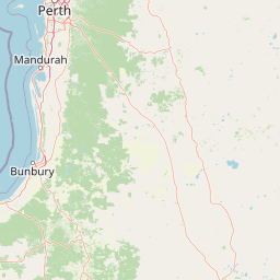
Map view of Lesmurdie Falls National Park

Use this park location map to pinpoint Lesmurdie Falls National Park in Australia, understand its exact geographic position, and read its mapped placement within the surrounding landscape more clearly.

Pigeon | © OpenStreetMap contributors

Location context for Lesmurdie Falls National Park

Western Australia
Park atlas

Compare diverse park geography across the Darling Scarp and Swan Coastal Plain in Western Australia

Discover Other National Parks and Protected Areas Near Lesmurdie Falls National Park

Continue your exploration of Western Australia's protected areas by browsing other national parks and reserves situated near Lesmurdie Falls National Park. Explore diverse landscapes, from additional waterfall sites along the Darling Scarp to coastal plains, enhancing your understanding of regional conservation.
National parkWestern Australia
About 2.7 km away#1 closest

Southeast

Korung National Park: Protected Landscape and Map Context in Western Australia

Discover its unique dual bioregion geography.

Korung National Park is a protected national park in Western Australia, noted for its position along the Darling Scarp overlooking the Swan Coastal Plain. This reserve provides accessible natural experiences and showcases the ecological transition between two major southwest Australian bioregions. Its mapped landscapes offer a clear example of regional protected area planning and its importance for biodiversity conservation in the Perth metropolitan area.

Area
63.54 km²
Established
2004
IUCN
II
Relief
Mixed relief
Watercolor illustration of a landscape with rolling hills, trees, and fields
National parkWestern Australia
About 3.6 km away#2 closest

Northeast

Kalamunda National Park: Explore Darling Scarp Woodland & Western Australia's Natural Terrain

A protected national park with distinct mapped landscape features.

Kalamunda National Park is an essential protected area located on the western slopes of the Darling Scarp, offering a clear representation of southwestern Australia's characteristic eucalypt woodland ecosystems. Its geography is defined by the escarpment's terrain, supporting tall marri, jarrah, and wandoo forests with a diverse understorey. As a national park, it provides critical habitat and contributes to the regional landscape context within Western Australia, making it a valuable point for atlas-driven discovery of protected natural areas.

Area
3.75 km²
Established
1964
IUCN
II
Relief
Mixed relief
National parkWestern Australia
About 3.8 km away#3 closest

North

Gooseberry Hill National Park: A Protected Landscape in Western Australia's Geography

Explore mapped boundaries and regional park context.

Gooseberry Hill National Park is a significant protected area designated as a national park within the diverse geography of Western Australia. This entry provides detailed insights into its specific location, mapped boundaries, and role as a conservation landscape. Understand how Gooseberry Hill National Park contributes to the broader atlas of protected lands in Western Australia, offering a foundational view for geographic exploration and landscape context.

Area
0.33 km²
Established
1970
IUCN
II
Relief
Highland
National parkWestern Australia
About 4.9 km away#4 closest

East

Beelu National Park: Exploring Western Australia's Protected Jarrah-Marri Forest Landscape

Mapped Geographic Context & Natural Terrain Discovery

Beelu National Park, situated in Western Australia's Darling Range, offers an immersive experience within old-growth jarrah-marri forests. This protected area provides a vital glimpse into the region's natural landscapes, characterized by rolling hills and the Helena River valley. Users can explore the park's geographic setting, its mapped boundaries, and the unique ecological context it preserves. It stands as a significant natural reserve contributing to the understanding of Western Australia's conservation efforts and diverse terrain.

Area
46.17 km²
Established
1995
IUCN
II
Relief
Highland
National parkWestern Australia
About 7.9 km away#5 closest

North

Greenmount National Park: Western Australia National Park Landscape and Geography Atlas

Explore its protected boundaries and regional landscape context.

Greenmount National Park represents a distinct protected landscape within the diverse geography of Western Australia. As a National Park, its mapped boundaries are integral to understanding its regional context and offering users a point of detailed geographic discovery. This entry provides essential data on its protected status and geographic setting, supporting exploration of Australia's significant natural areas through an atlas-driven lens.

Area
2.02 km²
Established
1970
IUCN
II
Relief
Upland
National parkWestern Australia
About 10 km away#6 closest

North

John Forrest National Park: National Park Atlas and Western Australia Protected Landscape

Mapped boundaries and regional geographic context.

Delve into the atlas-level details of John Forrest National Park, a protected area situated in Western Australia. This park's designation as a national park provides a focal point for understanding its specific geographic features and mapped extent. Users can explore its place within the broader regional geography of Western Australia, gaining structured insight into the protected landscape.

Area
26.78 km²
Established
1900
IUCN
II
Relief
Upland
National parkPerth metropolitan region
About 15 km away#7 closest

Southeast

Midgegooroo National Park: Jarrah Forest Protected Landscape and Regional Geography

Explore its mapped boundaries and terrain near Perth.

Midgegooroo National Park offers a distinct protected landscape characterized by its expansive jarrah forest terrain within the Perth metropolitan region. This national park provides valuable context for understanding regional geography, mapped natural features, and the distribution of protected lands. Explore the park's unique topography and conservation boundaries, vital for comprehensive atlas-based geographic discovery.

Area
24.92 km²
Established
2004
IUCN
II
Relief
Upland
National parkWestern Australia
About 18 km away#8 closest

East

Helena National Park: National Park with Regional Geographic Context in Western Australia

Mapping protected area boundaries and natural landscapes.

Helena National Park represents a significant protected area within the expansive geography of Western Australia. This page facilitates detailed exploration of its national park status, offering insights into its mapped boundaries and the regional landscape context. Discover how Helena National Park contributes to the protected land atlas of Western Australia, providing a specific focus for geographic understanding and park exploration.

Area
122.55 km²
Established
2004
Relief
Upland
Climate
Mediterranean

Common questions about visiting, size, designation, and location context for Lesmurdie Falls National Park

Lesmurdie Falls National Park FAQs for park facts, access, geography, and protected area context

Find quick answers about Lesmurdie Falls National Park, including protected-area facts, park geography, trail and visitor context, and how the park fits into its surrounding country and regional landscape.
MoriAtlas Explorer

Continue Your Protected Areas Search Across the Global Atlas

Deepen your exploration by continuing the structured search for national parks and protected areas worldwide. Utilize the comprehensive filtering capabilities to compare different conservation landscapes and refine your understanding of global park geography. Discover more about the distribution and characteristics of protected natural areas.

Global natural geography