
Waterfalls
Park geography
Analyzing the protected boundaries, regional reach, and mountain elevation landscapes
Geographic Profile and Mapped Terrain of Serranía de la Neblina National Park
Serranía de la Neblina National Park spans 13600 square kilometers across the Amazonas region, bridging the territory between Venezuela and Peru. This geography profile details the mountain relief, including major peaks like Pico Phelps and Pico 31 de Março, alongside forest habitats and hydrological features such as the Río Baría.
Related tags
Tepui MountainsCloud ForestAmazon RainforestGuayanan HighlandsEndemic Species
Mist-shrouded tepui mountains in the Venezuelan Amazon
Serranía de la Neblina National Park
Serranía de la Neblina National Park is a vast protected area in southern Venezuela, established in 1978 and encompassing approximately 13,600 square kilometers of pristine Amazonian wilderness. The park centers on the Serranía de la Neblina, a dramatic mountain mass that rises from the Amazon basin to become the highest elevation in the entire Venezuelan Amazon region. Located in the state of Amazonas near the border with Brazil, this protected area forms part of a larger transboundary ecosystem that includes Pico da Neblina National Park on the Brazilian side. The park is named for the persistent cloud cover that envelops its peaks, earning the mountain the descriptive nickname "La Neblina" meaning "the mist" in Spanish. This isolated and rugged landscape represents one of the most ecologically significant protected areas in northern South America, sheltering unique habitats found nowhere else on Earth.
- Location
- Venezuela
- Park type
- National park
- Established
- 1978
- Area
- 13,600 km²
- Highest point
- 2,992 m
Location overview
Analyzing the transboundary reach across Amazonas, Peru, and Venezuela
Serranía de la Neblina National Park Geographic and Regional Map Profile
Serranía de la Neblina National Park is positioned across Peru and Venezuela within the Amazonas region. Transboundary records highlight its continental, non coastal geography within South American conservation networks.
- Countries
- Peru, Venezuela
- Regions
- Amazonas
- Primary location
- Amazonas
- Geographic setting
- Transboundary · Inland
Boundary and coordinates
Interactive boundary geometry and recorded 13600 square kilometre spatial metrics
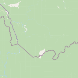
Serranía de la Neblina National Park Boundary Map and Spatial Extent
The mapped perimeter outline provides visual spatial context for the protected territory. Accompanying boundary facts detail calculated surface area coverage, coordinate limits, and regional spans.
- Boundary area
- 12,435.4 km²
- Boundary perimeter
- 774.6 km
- Northernmost point
- 1.9553° N
- Southernmost point
- 0.6474° N
- Easternmost point
- 65.206° W
- Westernmost point
- 66.5471° W
- Geographic centre
- 1.2759° N, 65.9317° W
- North–south span
- 144.6 km
- East–west span
- 149.3 km
Elevation and terrain
Mountain relief metrics and recorded natural features across the park
Serranía de la Neblina National Park Terrain and Elevation Profile
Explore the recorded elevation summary reaching up to 2992 meters across mountain terrain. Review structured cards detailing named peaks, rivers, and waterfalls located within boundaries.
- Maximum elevation
- 2,992 m
- Highest point
- 2,992 m
Selected named natural features
Peaks
Cerro de la Neblina
1,145 m
Peaks
Pico 31 de Março
2,973 m
Peaks
Cerro Cupi
840 m
Peaks
Pico Phelps
2,992 m
Peaks
Cerro Avispa
1,355 m
Environmental setting
Interpreting recorded mountain relief, forest cover, and habitat classifications
Serranía de la Neblina National Park Environmental Setting and Classification Data
Recorded landscape features, montane forests, and relief classifications form a structured profile of the physical setting. Associated data links these categories directly to broader regional atlas destinations.
- Relief
- Mountain
- Water
- Minor water
- Forest cover
- Mostly forested
- Seasonality
- Year-round
Landscape features
Mountains · Valleys · Canyon · Forest
Habitat types
Temperate broadleaf forest · Montane forest
Park atlas
Compare the vast protected landscapes and Amazonian wilderness surrounding Serranía de la Neblina National Park, tracing its regional context.
Discover Other National Parks and Protected Areas Near Serranía de la Neblina National Park
Explore more national parks and protected areas across the Guayanan Highlands and Amazon basin, revealing the diverse protected landscapes surrounding Serranía de la Neblina National Park. This geographical context facilitates comparing distinct ecosystems and conservation efforts within the broader South American wilderness, extending your atlas-based discovery.
National parkAmazonas
Park boundaries overlap#1 closest
Northeast

Parima Tapirapecó National Park: Venezuela's Largest Protected Area within the Guayanan Highlands
Explore its vast geographic extent and critical Orinoco River basin landscape.
Parima Tapirapecó National Park is an expansive protected territory in Venezuela's Amazonas region, holding the title of the country's largest national park and ranking among the world's most significant protected lands. Its geography is defined by the ancient Guayanan Highlands, protecting the vital headwaters of the Orinoco River and a mosaic of tropical forests and savannas. This park offers deep insights into landscape preservation on a grand scale, crucial for understanding regional geography and protected area distribution.
- Area
- 38,290 km²
- Established
- 1991
- IUCN
- II
- Scope
- Terrestrial
National parkAmazonas
153 km away#2 closest
North
Parque nacional Duida-Marahuaca: Geographic Overview of Protected Tepui Landscapes in Venezuela
Mapping the highland ecosystems and river systems of Amazonas
Parque nacional Duida-Marahuaca protects a vast expanse of remote wilderness, anchored by the prominent Cerro Duida, Cerro Huachamacari, and Cerro Marahuaca. This site offers deep insights into the park's sandstone topography and hydrological connectivity within the broader Guayana Shield, providing a clear geographic understanding of these isolated table-top mesas and their surrounding forest habitats.
- Area
- 2,100 km²
- Established
- 1978
- IUCN
- II
- Relief
- Mountain
National parkAmazonas
186 km away#3 closest
North
Yapacana National Park: Ancient Geology and Botanical Significance in Venezuela's Amazonas
Discover the dramatic plateau landscapes and unique flora of this protected national park.
Delve into the distinct geography and protected landscape identity of Yapacana National Park, a significant national park within Venezuela's Amazonas region. This page serves as a comprehensive atlas entry, detailing the park's core features, including its iconic Yapacana hill, a dramatic tepui formation representative of the ancient Guayana Shield. Understand the park's geological heritage and its exceptional botanical value, marked by unique floristic connections, all within the context of its Amazonian basin setting.
- Area
- 3,200 km²
- Established
- 1978
- IUCN
- II
- Relief
- Highland
National parkVenezuela
About 200 km away#4 closest
North
Duida, Marahuaca National Park: Venezuela's Remote Tepui National Park & Protected Landscape
Guiana Shield Geography and Cloud Forest Ecosystems
Duida, Marahuaca National Park in southern Venezuela is a protected national park defined by its spectacular tepui mountains and unique Guiana Shield geography. This park offers a glimpse into remote wilderness, characterized by dramatic sandstone formations and isolated cloud forest ecosystems that harbor endemic species. Understand the mapped extent and geographic context of this remarkable protected landscape, vital for comprehending regional natural heritage and evolutionary distinctiveness.
- IUCN
- II
- Scope
- Terrestrial
National parkGuainía Department
245 km away#5 closest
West

Puinawai Natural Reserve National Park: Mapped Protected Landscape in Guainía Department
Explore exceptional Amazonian biodiversity and pristine natural terrain.
Puinawai Natural Reserve is a sprawling national park situated in the remote Guainía Department of Colombia. As one of the largest and most ecologically intact protected areas in the Amazon basin, it preserves a unique mosaic of humid tropical rainforest, tropical open savanna, and transitional zones. The park's immense size and isolation contribute to its remarkable state of preservation, offering a significant opportunity for atlas-driven discovery of its mapped boundaries, diverse ecosystems, and complex hydrological geography at the Amazon-Orinoco divide.
- Area
- 10,925 km²
- Established
- 1989
- IUCN
- II
- Relief
- Lowland
National parkBolívar
313 km away#6 closest
Northeast
Parque nacional Jaua-Sarisariñama: Protected Tepui Landscapes in Bolívar
Mapping the sandstone mesas and remote wilderness of the Venezuelan Guiana Shield.
Parque nacional Jaua-Sarisariñama stands as one of the most secluded protected areas in Venezuela, defined by its massive tepuis and dramatic vertical sinkholes. This geography encompasses critical headwaters and ancient Precambrian rock formations that rise abruptly from surrounding lowland forests, providing a stable habitat for isolated species across the Guiana Shield.
- Area
- 3,300 km²
- Established
- 1978
- IUCN
- II
- Relief
- Highland
Natural monumentVenezuela
About 394 km away#7 closest
North
Monumento Natural Formaciones de Tepuyes: Protected Landscapes and Geological Map
Ancient tepuy table-top mountains in the Venezuelan Guayana Shield
Monumento Natural Formaciones de Tepuyes spans over one million hectares, safeguarding extraordinary geological formations defined by sheer vertical escarpments and flat-topped summits. As a vital protected area within the Guayana Shield, the site offers an essential view into isolated highland geography, endemic ecosystems, and the contrast between ancient mountain plateaus and tropical forest lowlands.
- Area
- 10,698.2 km²
- Established
- 1991
- Relief
- Mountain
- Climate
- Tropical
National parkVichada Department
401 km away#8 closest
Northwest
El Tuparro National Natural Park: Mapped Protected Landscape in Colombia's Vichada Department
Explore the geography and savanna terrain of this Orinoco basin national park.
El Tuparro National Natural Park stands as a significant protected area in the Vichada Department, embodying the ecological richness of Colombia's Llanos Orientales. Its landscape comprises extensive tropical savannas, striking gallery forests along major rivers like the Orinoco, and dramatic rapids. This page provides an atlas-focused view of El Tuparro National Natural Park, detailing its geographic boundaries and its importance as a conservation corridor within the region, crucial for understanding South American protected lands.
- Area
- 5,480 km²
- Established
- 1970
- IUCN
- II
- Relief
- Lowland
MoriAtlas Explorer
Continue Exploring the Geography and Protected Boundaries of Serranía de la Neblina National Park
Delve deeper into the atlas of Serranía de la Neblina National Park, a prime example of Guayanan Highlands geography and unique cloud forest ecosystems. Understanding its mapped terrain and protected landscape identity offers critical insights into the region's natural heritage and helps build a comprehensive geographic context for this significant Venezuelan protected area.
Browse next
Global natural geography
Explore related park routes
Explore MoriAtlas Global ParksBrowse All MoriAtlas ParksGlobal Park Map DiscoveryMoriAtlas: Browse All CountriesBrowse All MoriAtlas ContinentsNational Park Environment AtlasGrand Canyon National Park AtlasYellowstone National Park AtlasYosemite National Park Atlas and GeographySerengeti National Park AtlasGalápagos National Park Protected LandscapeBanff National Park Geography and AtlasKruger National Park Atlas EntryUluṟu-Kata Tjuṯa National Park AtlasExplore Uluru-Kata Tjuta National Park GeographyPlitvice Lakes National Park AtlasFiordland National Park Protected LandscapeGreat Smoky Mountains National Park AtlasAfghanistan National Parks and Protected AreasAlbania National Parks and Protected AreasAlgeria National Parks and Protected AreasAmerican Samoa National Parks and Protected AreasAndorra National Parks and Protected AreasAngola National Parks and Protected AreasAntarctica National Parks and Protected AreasAntigua and Barbuda Park List