Mori Atlas logo
National parkShorsky National Park

Tracing the protected boundaries, rugged ridgelines, and old-growth coniferous forests of the Gornaya Shoria region

Shorsky National Park: An Atlas of Mountain Taiga and River Landscapes in Southern Siberia

Shorsky National Park safeguards a vast expanse of dark coniferous mountain taiga within the Gornaya Shoria massif of Kemerovo Oblast. This protected area features a complex geography defined by the deep river valleys of the Mras-Su, steep slopes, and high ridges reaching over 1,600 meters. The landscape provides a critical refuge for boreal wildlife, native Siberian plant species, and cultural heritage, representing one of the most intact ecological corridors in the Altai-Sayan region.

mountain taigadark coniferous forestSiberian stone pine forestAltai-Sayan regionGornaya ShoriaKemerovo Oblast

Shorsky National Park

National park

Park overview

Structured park overview, official facts, and landscape profile for Shorsky National Park

Shorsky National Park park facts, protected area profile, and essential visitor context

Review the core facts for Shorsky National Park, including designation, size, terrain, visitor scale, habitats, and operating context in one park-focused overview.

About Shorsky National Park

Shorsky National Park occupies a central position within the Gornaya Shoria region, a mountain system in southwestern Siberia that is bordered by the Salair Ridge to the west, the Altai mountains to the south, and the Kuznetsk Alatau and Western Sayan ranges to the east. This geographic framing gives the park its strongly continental climate and creates a landscape of deeply incised valleys, steep slopes, and isolated summits.

The core of the park's identity lies in its forests. Nearly the entire territory is covered by dark coniferous taiga, with Siberian stone pine (often called Siberian cedar) and Siberian fir as the dominant tree species. Spruce, common pine, birch, and aspen appear as secondary components, while the understory is rich with tall herbaceous vegetation, ferns, and sub-alpine plants. The most extensive forest communities are large-herb and broad-herb types, which support significant plant diversity, including rare species such as Siberian candytuft (Erythronium sibiricum), large-flowered lady's slipper (Cypripedium macranthos), true lady's slipper (Cypripedium calceolus), and golden root (Rhodiola rosea).

The park's terrain is shaped by the Mras-Su river, which flows north to south through the heart of the territory and divides it roughly into two equal halves, accompanied by a dense network of tributaries and streams. This river system, fed primarily by precipitation and groundwater, defines the park's hydrology and supports populations of Siberian grayling, lenok, and common taimen. Snowfall is heavy and persistent; the snow cover lasts more than half the year, often exceeding two meters in depth in mid-mountain depressions.

Beyond its natural values, Shorsky National Park carries strong cultural significance. The Shor people, an indigenous Turkic-speaking group historically tied to hunting and taiga culture, have inhabited this region for centuries, and the park includes cultural and natural heritage sites such as waterfalls, caves, and geological landmarks. Established in the final years of the Soviet era and now part of the Altai-Sayan ecological network, the park functions both as a refuge for boreal ecosystems and as a cultural landscape preserving the identity of Mountain Shoria.

Quick facts and research context for Shorsky National Park

Shorsky National Park lies in the Tashtagol district of Kemerovo Oblast, within the Gornaya Shoria mountain system of southwestern Siberia. Established in 1989 by a resolution of the Council of Ministers of the RSFSR, the park spans roughly 4,140 square kilometers and is organized into five forest districts administered from Tashtagol.

The park's natural zone is mountain taiga. Average elevations range between 500 and 800 meters, with individual summits reaching approximately 1,600 to 1,800 meters, including Mount Lysukha at 1,648 meters. The climate is sharply continental, with long snowy winters and short warm summers, and precipitation reaching up to 1,500 to 1,800 millimeters on windward mountain slopes. Shorsky is part of the association of reserves and national parks of the Altai-Sayan ecological region and was named in honor of Sergei Dmitrievich Tivyakov in October 2022.

Protection and recognition

Examine the terrestrial protection scope and documented designation framework.

Shorsky National Park Protection Status and Conservation Governance

Terrestrial protection parameters define the official conservation framework established for Shorsky National Park. Documented administrative records outline the governance scope and international recognition status associated with this protected landscape.

Protection details

Protection scope
Terrestrial
Transboundary protection
No
Park context

Deeper park guide and search-rich context for Shorsky National Park

Shorsky National Park history, landscape, wildlife, and travel context

Explore Shorsky National Park through its history, landscape character, ecosystems, wildlife, conservation priorities, cultural context, and seasonal travel timing in a structured park guide built for atlas discovery and search intent.

Why Shorsky National Park stands out

Shorsky National Park is best known for its vast expanse of dark coniferous mountain taiga, dominated by Siberian stone pine (Siberian cedar) and Siberian fir, set within the rugged ridges of Gornaya Shoria. The park protects one of the most representative examples of southern Siberian taiga, where old-growth forests, deep river valleys, and isolated mountain peaks combine to create a near-wilderness landscape. The area is equally recognized for the richness of its boreal wildlife, including brown bear, moose, Siberian musk deer, sable, lynx, and a wide spectrum of taiga birds, as well as for rare plant species such as Siberian candytuft and large-flowered lady's slipper orchid. Together, these qualities make Shorsky a defining example of an Altai-Sayan mountain taiga protected landscape.
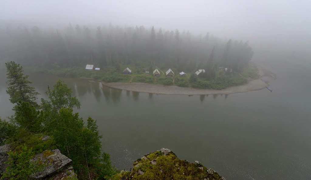
A wide angle view of a river bending around a forested bank where a series of small cabins or outposts are situated, all shrouded in heavy morning fog.
A foggy morning view of the Mednaya outpost situated along the river in Shorsky National Park.

Shorsky National Park history and protected-area timeline

Shorsky National Park was established in 1989, the same year as several other major Soviet-era national parks, following a resolution of the Council of Ministers of the RSFSR dated 27 December 1989 that authorized the creation of the Shorsky State Natural National Park in Kemerovo Oblast. The park was conceived as a means to protect the mountain taiga of Gornaya Shoria from growing pressures linked to forestry, mining, and expanding Soviet-era industry in southern Siberia, while also safeguarding the cultural landscape of the indigenous Shor people.

Since its creation, the park has been organized into five forest districts and administered from the town of Tashtagol, the main settlement of the region. It joined the association of reserves and national parks of the Altai-Sayan ecological region, linking it into a wider trans-boundary network of protected areas across the mountains of southern Siberia and northern Central Asia. In a more recent development, on 20 October 2022, the park was officially named after Sergei Dmitrievich Tivyakov, a figure associated with its history. Over time, Shorsky National Park has become a key institution for conservation, scientific research, and regulated nature tourism in Kemerovo Oblast and the broader Altai-Sayan region.

Shorsky National Park landscape and geographic character

The landscape of Shorsky National Park is defined by mountain taiga shaped by deep river erosion. The relief consists of a complex mountain system strongly dissected by river valleys, with average elevations between 500 and 800 meters and individual summits reaching roughly 1,600 to 1,800 meters. Notable peaks include Mount Lysukha at 1,648 meters and Mount Kubez at 1,555 meters. These ridges create a varied topography of steep slopes, narrow valleys, and broader mid-mountain basins.

Hydrologically, the park's defining feature is the Mras-Su river, which crosses the main massif from north to south and splits the territory into approximately two equal halves. Its tributaries form a dense network of rivers and streams that carve the mountains and govern the distribution of soils and vegetation. Rivers are fed mainly by atmospheric precipitation and groundwater, with a regime typical of mountain streams.

The climate strongly shapes the visible landscape: sharply continental and severe, with mean January temperatures around minus 20 to minus 22 degrees Celsius, mean July temperatures of plus 17 to plus 18 degrees, and snow cover lasting from October through April. Annual precipitation averages around 900 millimeters, but windward mountain slopes can receive 1,500 to 1,800 millimeters per year, producing deep snow accumulation, especially in middle-mountain hollows where snow depths can exceed four meters.

Shorsky National Park ecosystems, habitats, and plant life

The vegetation of Shorsky National Park is dominated by dark coniferous mountain taiga, often called chernnevaya taiga, one of the signature forest formations of southern Siberia. The principal tree species are Siberian stone pine (Pinus sibirica) and Siberian fir (Abies sibirica); spruce, common pine, downy birch, and aspen are present as secondary species. The age structure of the forests shows a large share of middle-aged and maturing stands, while mature and old-growth forest accounts for roughly one fifth of the forested area.

Most forest communities are large-herb and broad-herb types, with rich shrub and tall herb understories that include ferns such as lady fern and bracken, alongside tall forbs like northern aconite, tall larkspur, and sweet cicely. Moss and shrub-herb forest types with bird cherry and rowan in the understory are less common but still ecologically important. In the middle-mountain forests of Shoria, the park preserves a unique and species-rich flora of the Southern Siberian mountains, including botanical rarities such as Siberian candytuft, large-flowered lady's slipper, true lady's slipper, and golden root.

Soils reinforce this forest identity. Sod-podzolic soils dominate the lower part of the taiga belt, while typical podzolic soils prevail in its upper part. Both soil types are favorable for tree growth, and together with the humid climate they sustain the park's extensive and continuous forest cover, creating one of the largest expanses of intact mountain taiga in the region.

Shorsky National Park wildlife and species highlights

The fauna of Shorsky National Park reflects the richness of southern Siberian taiga and includes both game species and rare or ecologically notable animals. The mammalian fauna is particularly diverse for a protected taiga landscape; common game and furbearer species include the mountain hare, red squirrel, sable, American mink, Siberian weasel, otter, wolverine, red fox, gray wolf, Eurasian lynx, and European moose. Smaller mammals are also well represented, with species such as the Siberian mole, Siberian chipmunk, water vole, muskrat, common hamster, stoat, least weasel, steppe polecat, Asian badger, and various shrews inhabiting the park.

Larger mammals extend the ecological profile of the park. European brown bear is present throughout the forested terrain, while ungulates include the European moose, Siberian roe deer, the Altai wapiti (a regional subspecies of red deer), and notably Siberian musk deer, a taiga specialist associated with old-growth coniferous forests. Reindeer also occur in the area. In the rivers, cold-water fish species such as Siberian grayling, lenok, and common taimen maintain populations that depend on the park's clean mountain waters.

Birdlife in Shorsky is rich; the park has recorded a substantial number of bird species, including many that are traditional objects of hunting in the region. Waterfowl such as mallard, shoveler, pintail, gadwall, garganey, Eurasian teal, and common pochard occur alongside game birds like capercaillie, hazel grouse, black grouse, common quail, corncrake, Eurasian woodcock, common snipe, great snipe, and jack snipe. Rarer and more ecologically sensitive species documented in the park include the black stork, golden eagle, peregrine falcon, and osprey, all of which add to the conservation significance of the bird community. Reptile and amphibian presence is more modest but still contributes to the natural diversity of the area.

Shorsky National Park conservation status and protection priorities

Shorsky National Park plays a key conservation role within the Altai-Sayan ecological region, one of the last large contiguous mountain wildernesses of southern Siberia. By protecting roughly 4,140 square kilometers of dark coniferous taiga, river valleys, and alpine terrain, the park safeguards forest ecosystems that have been heavily altered elsewhere in southern Siberia by industrial logging, mining, and associated infrastructure. The presence of extensive stands of Siberian stone pine and Siberian fir, along with substantial populations of species such as brown bear, Siberian musk deer, sable, and lynx, makes the park an important stronghold for taiga biodiversity at a regional scale.

The park also preserves populations of ecologically sensitive and legally protected species in Russia, including the black stork, golden eagle, peregrine falcon, and osprey, alongside rare plants such as large-flowered and true lady's slipper orchids and golden root. The combination of altitudinal variation, heavy snowfall, and deep forest cover creates refuge habitats that are resilient to many forms of human pressure but sensitive to disturbance, which is the core reason for the park's protected status. Inclusion in the association of reserves and national parks of the Altai-Sayan ecological region further strengthens its role in trans-regional conservation planning.

Shorsky National Park cultural meaning and human context

The territory of Shorsky National Park corresponds closely with the homeland of the Shor people, a small indigenous Turkic-speaking group traditionally associated with hunting, reindeer herding, and taiga forest culture in the mountains of southwestern Siberia. The name Shorsky itself reflects this association, and the park's borders encompass many Shor villages and historical settlements, including the communities reflected in the names of its forest districts.

Cultural and natural heritage sites are recognized across the park. The territory includes 25 officially designated natural monuments, six of which are most accessible and visited. These include the Saga waterfall, a hydrological monument, and several geological landmarks such as the Kizassky caves, the Nadezhda cave, the Soldier monument, the Drinking Elephant rock, and the Kabuksky vaucluse spring. The open-air ethnographic museum at Tazgol, located nearby, alongside traditional Shor settlements along the Mras-Su valley, anchors the park within the living cultural landscape of Mountain Shoria, where indigenous identity, taiga livelihoods, and natural heritage remain closely interwoven.

Top sights and standout views in Shorsky National Park

Among Shorsky's standout features is the expanse of dark coniferous mountain taiga dominated by Siberian stone pine and Siberian fir, which forms one of the largest intact taiga landscapes remaining in the Altai-Sayan region. The river network of the Mras-Su and its tributaries shapes the park's geography and supports cold-water fish populations such as Siberian grayling, lenok, and common taimen.

The park also stands out for the combined presence of large mammals such as brown bear, Eurasian lynx, moose, Siberian musk deer, and the Altai wapiti, alongside rare breeding birds including black stork, golden eagle, peregrine falcon, and osprey. Botanical rarities such as Siberian candytuft, large-flowered lady's slipper, true lady's slipper, and golden root add a distinctive floristic profile. Together with its cultural ties to the Shor people and natural monuments like the Saga waterfall and the Kizassky caves, these qualities make Shorsky a uniquely comprehensive mountain taiga protected area.

Best time to visit Shorsky National Park

Summer is the most accessible and ecologically expressive season in Shorsky National Park, when the deep snow has receded and the mountain rivers become workable for rafting and other water-based travel. This is when the dark coniferous forests are fully active, the tall herbaceous understory is at its most lush, and conditions for hiking, horseback riding, ascents to peaks such as Mount Lysukha, and caving in the park's geological monuments are favorable. Warm daytime temperatures around plus 17 to plus 18 degrees Celsius, combined with long daylight hours, make mid-mountain routes feasible without specialized winter equipment.

Winter, in contrast, is long, severe, and snow-dominated, with temperatures around minus 20 to minus 22 degrees Celsius in January and snow lasting more than half the year, often accumulating to depths of two meters or more in middle-mountain hollows. While the park's snow cover, frozen rivers, and frost-laden taiga create a strongly Siberian winter landscape, travel in this season demands significantly more preparation and is a more specialized experience.
Monthly climate preview

Examine long-term representative temperature ranges and monthly precipitation rhythm across the park coordinate

Shorsky National Park Climate Normals and Annual Temperature Patterns

Long-term data records demonstrate wide monthly temperature swings and varying precipitation levels across the representative elevation of Shorsky National Park. Reviewing the complete twelve-month climatology profile provides deeper insight into measured meteorological patterns across the protected landscape.
Annual mean1 °C
-16 °C18 °C
Jan-16°
Feb-13°
Mar-7°
Apr2°
May9°
Jun15°
Jul18°
Aug16°
Sep9°
Oct1°
Nov-8°
Dec-13°
Warmest month
July

17.8 °C

Coolest month
January

-15.7 °C

Wettest month
July

3.3 mm/day

Driest month
February

1 mm/day

Park location guide

Geography guide, regional context, and park location map for Shorsky National Park

Shorsky National Park park geography, regions, and map view in Russia

Understand where Shorsky National Park sits in Russia through a broader geographic reading of the surrounding landscape, nearby location context, and its mapped position within the national park landscape.

How Shorsky National Park fits into Russia

Russia is a transcontinental nation spanning eleven time zones, bordered by fourteen countries. It is the world's largest country by area, covering 17,098,246 km². Moscow is the capital and largest city, while Saint Petersburg is the second-largest and a major cultural centre.

Wider geography shaping Shorsky National Park in Russia

Russia spans Eastern Europe and North Asia, covering 17,098,246 km². It shares land borders with fourteen countries, more than any other nation, and spans eleven time zones. The landscape includes vast plains, mountain ranges such as the Urals and Caucasus, and extensive coastlines along the Arctic Ocean, Pacific Ocean, Baltic Sea, Black Sea, and Caspian Sea.

Map view of Shorsky National Park

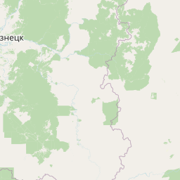
Use this park location map to pinpoint Shorsky National Park in Russia, understand its exact geographic position, and read its mapped placement within the surrounding landscape more clearly.

Pigeon | © OpenStreetMap contributors

Location context for Shorsky National Park

Kemerovo Oblast

Visual reference collection showcasing dark coniferous forests, river valleys, and rugged Siberian terrain.

Shorsky National Park Photos, Taiga Landscapes, and Mountain Scenery

Visual records capture the dense Siberian fir forests, steep mountain ridges, and carved river valleys that define the protected landscape. Examining actual park photography helps researchers evaluate remote topography, boreal habitats, and mountain taiga characteristics across southern Siberia.

A wide angle view of a river bending around a forested bank where a series of small cabins or outposts are situated, all shrouded in heavy morning fog.

Park atlas

Compare surrounding southern Siberian taiga and regional mountain reserves

Parks Near Shorsky National Park And Related Protected Landscapes

Browsing parks near Shorsky National Park reveals connected mountain taiga and river valley terrain across the Altai-Sayan region. Expanding the geographic comparison highlights broader protected landscapes and regional conservation areas.
Watercolor painting of a river flowing through a valley with forested hills and distant mountains
National parkTashtagolsky District
About 0 km away#1 closest

Southwest

Shorsky National Park: Protected Taiga and Karst Landscapes in Tashtagolsky District

Mapping the mountainous wilderness of southern Siberia

Shorsky National Park protects vast swathes of dark taiga forest and dramatic karst features across 4,180 square kilometers of rugged mountain terrain. Explore the geography of this Siberian region, featuring over 60 named caves, deep river valleys, and significant rock formations that define the natural character of the Tashtagolsky District.

Area
4,180 km²
Established
1989
IUCN
II
Relief
Mountain
Watercolor painting showing a river flowing through a forested area with distant hills, using soft green, blue, and yellow tones
National parkAltai Krai
About 165 km away#2 closest

Northwest

Salair National Park: Mapped Protected Landscape and Geographic Features in Altai Krai

Discover the unique dark taiga terrain and relict flora.

Salair National Park is a significant protected area in Altai Krai, Russia, renowned for its exceptionally biodiverse dark taiga forests, often called the "rainforest of Siberia." Established in 2020, the park spans the western slopes of the Salair Ridge, covering about 161,000 hectares of gentle low mountain terrain. Its landscape is characterized by rounded mountains, a network of ravines, and the preservation of pre-glacial relict plant species. This national park offers a vital contrast to the surrounding agricultural areas, highlighting its role in conserving unique Siberian forest ecosystems and their historic flora.

Area
1,612 km²
Established
2020
IUCN
II
Relief
Upland
Watercolor painting of green trees, rolling hills, a pink and yellow sunset sky, and a single tree on the right
National parkKrasnoyarsk Krai
About 215 km away#3 closest

East

Shushensky Bor National Park: Mapped Geography of a Siberian Protected Forest

Explore the protected landscape and regional context of Krasnoyarsk Krai.

Shushensky Bor National Park serves as a critical protected area within the vast geography of Krasnoyarsk Krai, Russia, offering detailed insights into Siberia's ecological transition zones. This national park meticulously maps the shift from the Minusinsk basin forest-steppe to the dramatic mountain taiga of the Western Sayan range. Users can explore its varied terrain, from gentler northern steppe-influenced lands to the rugged slopes of the Borus Massive, all within a defined protected landscape. The proximity to the Sayano-Shushenskoye Reservoir further defines its unique geographic setting, providing context for its conservation importance and natural beauty.

Area
392 km²
Established
1995
IUCN
II
Relief
Mountain
Watercolor painting of a river flowing through forested hills with mountains in the background under a sunset sky
National parkEast Kazakhstan Region
About 329 km away#4 closest

South

Katon-Karagay National Park: Discover Kazakhstan's Largest Protected Mountain Landscape

Explore the geography and park boundaries of East Kazakhstan's premier national park.

Katon-Karagay National Park, the largest national park in Kazakhstan, offers a deep dive into the protected landscapes of the Southern Altai Mountains. This page provides essential geographic context, detailing the park's terrain, its significance as a protected area within East Kazakhstan Region, and its role in mapping the natural contours of this ecologically diverse mountain system. Understand the park's boundaries and its contribution to regional conservation.

Area
6,435 km²
Established
2001
IUCN
II
Relief
Mountain
Watercolor painting showing green mountains, valleys, and a winding river under a light sky
National parkAltai Republic
About 336 km away#5 closest

South

Saylyugemsky National Park: Discover its Protected Landscape and Geographic Significance in Altai Republic

Mapped boundaries and regional landscape context within the Altai Republic.

Delve into Saylyugemsky National Park, a designated national park situated within the vast geographic expanse of Russia's Altai Republic. This canonical page provides detailed insights into its protected landscape, meticulously mapped boundaries, and its contribution to the regional geography. MoriAtlas focuses on structured geographic discovery, enabling a deeper understanding of Saylyugemsky National Park's place within the atlas of protected areas and natural landscapes.

Area
1,183.8 km²
Established
2012
IUCN
II
Relief
Mountain
National parkBayan-Ölgii Province
About 370 km away#6 closest

South

Altai Tavan Bogd National Park: Protected Mountainous Landscape in Bayan-Ölgii

Explore mapped geography and protected terrain.

Altai Tavan Bogd National Park, situated in Mongolia's Bayan-Ölgii Province, offers a detailed view of a significant protected natural area. This park is defined by its mountainous geography, forming a key part of the Altai range. Users can explore its mapped boundaries and understand its role as a protected landscape within the western Mongolian atlas.

Area
6,362 km²
Established
1996
IUCN
II
Relief
Mountain
A wide, panoramic watercolor illustration showing a mountain range with purple and yellow hues in the background, a green grassy meadow in the middle ground, and small pine trees and wildflowers in the foreground against a white background.
Nature reserveKazakhstan
About 383 km away#7 closest

Southwest

West Altai State Nature Reserve: Protected Mountain Taiga and Alpine Geography in Kazakhstan

An ecological atlas of the Western Altai mountain system

Spanning the Ivanovsky and Uba ranges, this nature reserve protects a diverse terrain of mountain taiga, glacial cirques, and high-mountain bogs. It remains a key conservation landscape for Central Asian biodiversity, anchoring the headwaters of the Uba River within a striking environment of granite pillars and alpine meadows.

Area
861.22 km²
Established
1992
Relief
Mountain
Climate
Boreal
Watercolor painting showing pinkish rock pillars, green forests, and distant mountains in a landscape
National parkKrasnoyarsk Krai
About 454 km away#8 closest

Northeast

Krasnoyarsk Pillars National Park: Geographic Atlas and Protected Landscape Exploration

Discover mapped terrain and regional park context in Siberia.

This detailed entry for Krasnoyarsk Pillars National Park offers an in-depth look at its identity as a protected landscape within Krasnoyarsk Krai. It provides structured geographic information, focusing on mapped boundaries and the park's position within the vast Siberian terrain. Users can leverage this data for atlas exploration, gaining a clear understanding of the park's physical dimensions and its role in the regional geography of Russia. Explore the unique landscape character and mapped context of this significant national park.

Area
471.54 km²
Established
2019
IUCN
II
Visitors
200K annual

Common questions about visiting, size, designation, and location context for Shorsky National Park

Shorsky National Park FAQs for park facts, access, geography, and protected area context

Find quick answers about Shorsky National Park, including protected-area facts, park geography, trail and visitor context, and how the park fits into its surrounding country and regional landscape.
MoriAtlas Explorer

Continue Your Protected Areas Search Across the Global Atlas

Deepen your exploration by continuing the structured search for national parks and protected areas worldwide. Utilize the comprehensive filtering capabilities to compare different conservation landscapes and refine your understanding of global park geography. Discover more about the distribution and characteristics of protected natural areas.

Global natural geography