Mori Atlas logo
National parkSierra de las Quijadas National Park

Discover the unique ecotone where Semiarid Chaco and High Monte landscapes converge.

Sierra de las Quijadas National Park: Protected Landscape and Geographic Atlas of Argentina

(Parque Nacional Sierra de las Quijadas)

Sierra de las Quijadas National Park in San Luis Province, Argentina, represents a vital conservation area situated at the confluence of the Semiarid Chaco and High Monte ecoregions. This unique geographic position creates a dynamic ecotone that harbors remarkable biodiversity and showcases striking geological formations, including ancient red sandstone cliffs and Cretaceous-era fossils. The park's landscape is characterized by rugged mountain ranges rising from semiarid plains, offering a distinct regional geography perfect for atlas-style exploration of protected lands.

National ParkArgentinaSemiarid ChacoHigh MonteEcotoneMountain Landscape

Sierra de las Quijadas National Park

National park

Park overview

Structured park overview, official facts, and landscape profile for Sierra de las Quijadas National Park

Sierra de las Quijadas National Park park facts, protected area profile, and essential visitor context
Review the core facts for Sierra de las Quijadas National Park, including designation, size, terrain, visitor scale, habitats, and operating context in one park-focused overview.

About Sierra de las Quijadas National Park

Sierra de las Quijadas National Park protects a distinctive landscape where the semiarid plains of central Argentina give way to a cluster of low mountains rising abruptly from the surrounding terrain. The park's setting within the San Luis Basin places it at a critical biogeographic crossroads, where the extensive Gran Chaco woodland to the east meets the High Monte desert-scrub formations of the western piedmont. This transitional position has created a complex mosaic of habitats that supports remarkable biological diversity despite the region's generally harsh and water-limited conditions. The park's establishment in 1991 reflected growing recognition that this ecotone, representing the only significant protected area capturing the Chaco-Monte transition in San Luis Province, required formal conservation status to ensure the long-term preservation of its unique ecological assemblages. Beyond its biological importance, the Quijadas range contains an extraordinary geological record. The mountains contain formations spanning roughly 120 million years of Earth history, from the Lower Cretaceous sedimentary layers that filled an ancient basin to the Tertiary deposits laid down during the uplift events that created the modern Sierras Pampeanas. The red and gray sandstone cliffs, the deeply eroded valleys, and the distinctive layered rock faces create a visually striking landscape that contrasts sharply with the more uniform plains surrounding the range.

Quick facts and research context for Sierra de las Quijadas National Park

Sierra de las Quijadas National Park occupies 73,533 hectares in northwestern San Luis Province, Argentina, at coordinates 32.55°S 67.06°W. The park was established in 1991 under IUCN Category II protection. It sits at the intersection of two major ecoregions, the Semiarid Chaco and the High Monte, creating a biologically significant transitional zone. Elevations range from below 500 meters in the Desaguadero River flood plain to approximately 1,090 meters at peaks like Cerro El Portillo. The climate is semi-arid with pronounced seasonal and daily temperature variations, with an annual average temperature of 13.7°C. The park contains significant paleontological resources, particularly the Loma del Pterodaustro fossil site known for exceptionally preserved pterosaur specimens.

Park context

Deeper park guide and search-rich context for Sierra de las Quijadas National Park

Sierra de las Quijadas National Park history, landscape, wildlife, and travel context
Explore Sierra de las Quijadas National Park through its history, landscape character, ecosystems, wildlife, conservation priorities, cultural context, and seasonal travel timing in a structured park guide built for atlas discovery and search intent.

Why Sierra de las Quijadas National Park stands out

Sierra de las Quijadas is best known for its remarkable position at the crossroads of the Semiarid Chaco and High Monte ecoregions, making it a biodiversity hotspot in Argentina's interior. The park preserves one of the few intact representations of this ecological transition zone, hosting species characteristic of both biomes. Its paleontological significance is equally remarkable, with the Loma del Pterodaustro fossil site yielding exceptionally preserved specimens of Pterodaustro guinazui, a Cretaceous pterosaur, so well-preserved that the site qualifies as a Konservat-Lagerstätte. The dramatic red sandstone cliff formations and layered geological strata visible throughout the park provide a vivid geological history spanning from the Lower Cretaceous through the Tertiary period.

Sierra de las Quijadas National Park history and protected-area timeline

The geological history of Sierra de las Quijadas spans approximately 120 million years, beginning with the formation of an ancient sedimentary basin flanked by highlands including what is now the Sierra de San Luis and an ancient mountain range along the present course of the Desaguadero River. Between 120 and 100 million years ago, this basin accumulated over 1,000 meters of fluvial, aeolian, and lacustrine sediments, creating the foundation of the range's geological architecture. Following a prolonged period of relative tectonic calm lasting roughly 75 million years, the region experienced significant uplift beginning around 25 million years ago as the South American Plate's westward migration and associated tectonic forces lifted, folded, and exposed these ancient layers. This uplift continues today, making the Quijadas one of the relatively few actively rising mountain ranges in Argentina. The park was formally established on December 10, 1991, by the Administración de Parques Nacionales to protect the natural features representative of both the Semiarid Chaco and High Monte ecoregions. Paleontological discoveries, particularly from the Lagarcito Formation beginning in the 1960s and 1970s when José Bonaparte first identified remains of Pterodaustro guinazui, have established the park as a site of significant scientific importance. The extensive excavations at Loma del Pterodaustro during the 1990s revealed abundant fossil material, including exquisitely preserved pterosaur specimens that constitute one of the most important Cretaceous fossil sites in South America.

Sierra de las Quijadas National Park landscape and geographic character

The Sierra de las Quijadas landscape is defined by a cluster of low but rugged mountains rising sharply from the semiarid plains of San Luis Province. The range's highest points, including Cerro El Portillo and Cerro El Lindo, reach elevations approaching 1,090 meters above sea level, while Cerro Los Viejos stands at 920 meters and the Cerros de la Aguada and Cerros de la Vidriera approach 850 meters. Between these peaks, erosion has carved deep valleys and ravines, with the Potrero de la Aguada valley representing a particularly distinctive enclosed basin that concentrates rainwater and channels it through a single outlet, Arroyo de la Aguada, toward the Desaguadero River. The park encompasses six distinct physiographic units: the Desaguadero River flood plain, the circular Arroyo de la Aguada valley, steppe communities, foothills zones, and the steeper slopes and summits of the range itself. The geological formations display vivid coloration, with red sandstone and claystone dominating the El Jume Formation while the El Toscal and La Cruz formations contribute reddish, whitish, and gray cliffs and gorges. The landscape bears the marks of both water and wind erosion, processes that continue to shape the terrain in this semiarid environment. Basaltic lava flows within the La Cruz Formation, dating to between 109.4 and 107.4 million years ago, provide evidence of volcanic activity during the Cretaceous period.

Sierra de las Quijadas National Park ecosystems, habitats, and plant life

The nature of Sierra de las Quijadas is defined by its position at the ecological interface between two major South American biomes. The park contains 416 identified plant species, including 17 introduced species, with the French tamarisk forming dense stands along stream banks representing the most conspicuous of these invasive plants. Two species, Senecio hualtaranensis and Atriplex quixadensis, are endemic to the park, existing nowhere else on Earth. The vegetation reflects the transitional nature of the site, with elements of both the Chaco woodland and the Monte scrub appearing in different parts of the park depending on aspect, elevation, and moisture availability. The semi-arid climate creates challenging conditions for plant life, with precipitation scarce and unevenly distributed throughout the year, falling primarily during the wet season from late spring through early autumn. The hydrographic network, while pronounced in terms of drainage patterns, consists entirely of ephemeral streams that carry water only during the wet season. The Potrero de la Aguada valley functions as a special case, collecting rainfall in an enclosed basin before releasing it through the single Arroyo de la Aguada outlet.

Sierra de las Quijadas National Park wildlife and species highlights

The wildlife of Sierra de las Quijadas reflects the park's position at the convergence of two distinct biomes, creating an assemblage of species representative of both the Chaco and the Monte. Approximately 270 vertebrate species have been recorded within the park, including 4 introduced species. The Chaco element is represented by species such as the gray brocket, Chacoan mara, blue-crowned parakeet, and Argentine boa, all characteristic of the woodland and savanna environments of the Gran Chaco. The Monte biome contributes distinctive species including the pink fairy armadillo, a specialized desert-dwelling armadillo, the sandy gallito, a ground-dwelling bird adapted to arid scrubland, and Darwin's tree iguana, a lizard species that thrives in the Monte's xeric conditions. This co-occurrence of species from such different ecological preferences within a single protected area makes Sierra de las Quijadas particularly valuable for understanding how species from contrasting habitats can coexist in transitional environments.

Sierra de las Quijadas National Park conservation status and protection priorities

Sierra de las Quijadas holds particular conservation significance as the only protected area in the San Luis Province that preserves the transitional zone between the Semiarid Chaco and High Monte ecoregions. This protected status ensures the preservation of representative flora and fauna from both biomes in a region where agricultural expansion and development have extensively modified natural habitats. The park's designation as an IUCN Category II national park reflects its primary objective of protecting natural ecosystems while allowing for sustainable visitor use and environmental education. The presence of two endemic plant species, Senecio hualtaranensis and Atriplex quixadensis, adds special conservation importance, as these species exist only within the park's boundaries and depend on the specific environmental conditions found here. The paleontological resources, particularly the Loma del Pterodaustro Konservat-Lagerstätte, represent another dimension of conservation value, preserving an exceptional window into Cretaceous ecosystems that cannot be replicated elsewhere.

Sierra de las Quijadas National Park cultural meaning and human context

The cultural context of Sierra de las Quijadas relates primarily to the region's geological and paleontological heritage rather than extensive human historical presence. The park's name, Sierra de las Quijadas, refers to the distinctive ridge or jaw-like mountain formation that characterizes the range. The area falls within the broader cultural landscape of the Cuyo region of Argentina, an area traditionally characterized by sparse population, extensive livestock ranching, and mining activities. The Lagunas de Guanacache wetland system, located approximately 80 kilometers northeast of the park near the borders of Mendoza, San Juan, and San Luis provinces, represents a historically significant wetland complex that was once part of a larger interconnected system fed by the Mendoza and San Juan rivers. While this wetland lies outside the park's boundaries, its historical extent and ecological connections to the broader Desaguadero River system provide regional context for understanding the hydrological and ecological dynamics that have shaped the Sierra de las Quijadas landscape.

Top sights and standout views in Sierra de las Quijadas National Park

The highlights of Sierra de las Quijadas include its unique position as a biodiversity bridge between the Chaco and Monte ecoregions, its dramatic red sandstone cliff formations and deeply eroded valleys, and its world-class paleontological site at Loma del Pterodaustro where exceptionally preserved pterosaur fossils have been discovered. The park offers visitors the opportunity to observe species from two major South American biomes in a single location, including the chance to encounter the pink fairy armadillo, one of the rarest and most specialized desert mammals. The geological exposures spanning over 100 million years of Earth history provide a remarkable window into the Cretaceous period, with visible fossil shells, ancient river channels, and volcanic lava flows layered within the mountainsides. The contrast between the mountain landscapes and the surrounding semiarid plains creates a striking visual environment that distinguishes this park from other protected areas in Argentina's interior.

Best time to visit Sierra de las Quijadas National Park

The best time to visit Sierra de las Quijadas depends on the type of experience sought, but the park is most comfortably explored during the cooler months from April through October when average temperatures range from the low teens to mid-twenties Celsius. The wet season, extending from late spring through early autumn, brings moisture that green the landscape and supports wildlife activity, though precipitation is uneven and may be sparse in any given year. The dry winter months typically offer clearer skies and more predictable conditions, though temperatures can drop significantly at night given the semi-arid climate and high elevation. Summer months, particularly January when average maximum temperatures reach 31°C, can be extremely hot and may limit outdoor activities during midday hours. Visitors interested in wildlife viewing may find the transitional seasons particularly rewarding, as the changing conditions influence animal behavior and visibility. The park's semi-arid conditions mean that conditions can change rapidly, and visitors should be prepared for variable weather regardless of the season chosen.
Park location guide

Geography guide, regional context, and park location map for Sierra de las Quijadas National Park

Sierra de las Quijadas National Park park geography, regions, and map view in Argentina
Understand where Sierra de las Quijadas National Park sits in Argentina through a broader geographic reading of the surrounding landscape, nearby location context, and its mapped position within the national park landscape.

How Sierra de las Quijadas National Park fits into Argentina

Argentina is a federal republic located in the southern cone of South America, bordering Chile, Bolivia, Paraguay, Brazil, Uruguay, and the Atlantic Ocean. With an area of 2,780,085 km², it is the second-largest country in South America and the eighth-largest globally. The capital and largest city is Buenos Aires, and the official language is Spanish. The country claims sovereignty over the Falkland Islands, South Georgia and the South Sandwich Islands, and a portion of Antarctica.

Wider geography shaping Sierra de las Quijadas National Park in Argentina

Argentina occupies the southern portion of South America, sharing the Southern Cone region with Chile to the west. The country borders Bolivia and Paraguay to the north, Brazil to the northeast, Uruguay and the South Atlantic Ocean to the east, and the Drake Passage to the south. The Andes mountain range runs along the western border, while the Pampas plains dominate the central region. Argentina also claims territories in Antarctica.

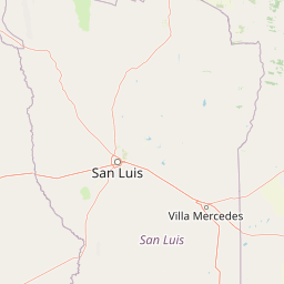
Map view of Sierra de las Quijadas National Park

Use this park location map to pinpoint Sierra de las Quijadas National Park in Argentina, understand its exact geographic position, and read its mapped placement within the surrounding landscape more clearly.

Pigeon | © OpenStreetMap contributors
Park atlas

Discover additional protected areas and explore their regional geographic context, extending beyond Sierra de las Quijadas National Park.

Explore National Parks and Protected Areas Near Sierra de las Quijadas National Park, Argentina
Browse national parks and protected areas near Sierra de las Quijadas National Park, exploring a curated selection of conservation landscapes across Argentina's central-western region. Discover how these adjacent protected areas feature varied ecoregions, distinctive geological formations, and diverse conservation efforts beyond the unique Chaco-Monte ecotone.
National park

El Leoncito National Park: High-Altitude Andean Puna and Steppe Protected Landscape

Explore mapped boundaries and unique geographic context in San Juan Province.

El Leoncito National Park in Argentina's San Juan Province preserves critical high-altitude ecosystems, including the Central Andean Puna and Southern Andean steppe. This protected landscape spans dramatic mountain terrain, with elevations reaching over 6,000 meters, providing a unique geographic setting. The park's conservation value is underscored by its representative ecological samples and stark natural beauty, offering a distinct regional geography for exploration.

Area
897.06 km²
Established
2002
IUCN
II
Relief
Mountain
National parkCórdoba Province

Quebrada del Condorito National Park: Mapped Protected Landscape and Biological Island Ecosystem

Argentina National Park in Córdoba Province

Quebrada del Condorito National Park is a federally protected area in Argentina's Córdoba Province, established to safeguard a significant portion of the Sierras Pampeanas mountain ecosystem. The park's rugged terrain, including deep gorges and high-altitude plateaus, creates a distinct biological island environment supporting a wealth of endemic species. Its geographic isolation and dramatic landscape make it a unique focus for protected-area discovery and understanding Argentina's natural geography.

Area
373.44 km²
Established
1996
IUCN
II
Relief
Mountain
National parkLa Rioja Province

Talampaya National Park: Argentinian National Park with Dramatic Desert Canyons

Explore protected landscape and mapped geography in La Rioja Province.

Talampaya National Park, a significant national park in Argentina's La Rioja Province, offers a profound exploration of a dramatic desert canyon environment. This protected area is renowned for its rich paleontological sites, yielding crucial dinosaur fossils, and for its well-preserved indigenous petroglyphs carved into ancient rock formations. Understanding Talampaya National Park provides vital context for the region's geography and its place within Argentinian protected lands and mapped natural landscapes.

Area
2,150 km²
Established
1997
IUCN
II
Relief
Mountain
Watercolor painting of a coastal landscape featuring palm trees, mountains, and a body of water
National parkValparaíso Region

La Campana National Park: Protected Landscape of Chilean Wine Palms

Explore its mapped terrain and regional geographic context.

La Campana National Park represents a significant protected landscape within Chile, celebrated for its exceptional concentration of Chilean Wine Palms (Jubaea chilensis). As a national park situated in the Valparaíso Region, it showcases a diverse range of Mediterranean ecosystems and dramatic coastal mountain terrain. This page provides detailed atlas-style context, highlighting the park's unique botanical heritage, its distinct geographic setting, and its importance as a mapped natural area for regional landscape studies.

Area
80 km²
Established
1967
IUCN
II
Visitors
39.6K annual
Watercolor illustration of mountain ranges with green and yellow hills, a central dark peak, and pinkish foreground
National park

San Guillermo National Park: High Andes Protected Landscape & Vicuña Conservation Area

Explore its rugged terrain and arid mountain ecosystem.

San Guillermo National Park, a key national park in Argentina's San Juan Province, protects over 166,000 hectares of high-altitude Andean wilderness. Its landscape is defined by arid mountain ranges and expansive puna grasslands, serving as a critical sanctuary for vicuñas and other high-Andean wildlife. This page offers detailed geographic context for understanding the park's protected boundaries, unique terrain, and its importance as a mapped conservation area.

Area
1,660 km²
Established
1998
IUCN
II
Relief
Mountain
National parkLibertador General Bernardo O'Higgins Region

Las Palmas de Cocalán National Park: Chile's National Park Protected Landscape Atlas

Explore geographic boundaries and regional context.

Delve into the protected landscape identity of Las Palmas de Cocalán National Park, situated within the Libertador General Bernardo O'Higgins Region. This page provides detailed atlas-style information, focusing on the park's geographic features and its role as a national park. Understand the mapped natural terrain and the regional importance of this conserved area for comprehensive geographic discovery.

Area
3.709 km²
Established
1971
IUCN
II
Relief
Mixed relief
Watercolor illustration of a river winding through a valley with rolling hills and green vegetation in the foreground.
National parkCoquimbo Region

Bosque de Fray Jorge National Park: National Park Protected Landscape & Geographic Atlas

Explore mapped boundaries and regional natural landscape context.

Bosque de Fray Jorge National Park is a key protected area offering unique insights into Chile's natural landscapes. This entry provides detailed geographic context, focusing on its status as a national park and its mapped boundaries within the Coquimbo Region. Discover its place in the regional atlas and understand its protected landscape identity for focused geographic exploration.

Area
100 km²
Established
1941
IUCN
II
Visitors
13.1K annual
National parkTucumán Province

Aconquija National Park: Southern Andean Yungas Protected Landscape in Tucumán Province

Explore its montane forest and mapped geographic context.

Aconquija National Park is a significant federal protected area located in Tucumán Province, Argentina. This national park is dedicated to conserving the diverse Southern Andean Yungas montane forest ecosystem, characterized by a dramatic elevational gradient. Its landscapes transition from cloud forest to high alpine terrain, offering a unique opportunity to study and appreciate a well-preserved montane environment within a critical geographic region. Discover the mapped extent and ecological importance of this protected area.

Area
700 km²
Established
1995
IUCN
II
Relief
Mountain

Common questions about visiting, size, designation, and location context for Sierra de las Quijadas National Park

Sierra de las Quijadas National Park FAQs for park facts, access, geography, and protected area context
Find quick answers about Sierra de las Quijadas National Park, including protected-area facts, park geography, trail and visitor context, and how the park fits into its surrounding country and regional landscape.
MoriAtlas Explorer

Continue Your Protected Areas Search Across the Global Atlas

Deepen your exploration by continuing the structured search for national parks and protected areas worldwide. Utilize the comprehensive filtering capabilities to compare different conservation landscapes and refine your understanding of global park geography. Discover more about the distribution and characteristics of protected natural areas.

Global natural geography
Sierra de las Quijadas National Park: Protected Landscape & Geography Atlas