
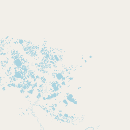
Lakes
Park geography
Detailed spatial analysis covering regional placement, topographic relief, and key natural landscapes.
Comprehensive Geographic Profile and Mapped Boundary Analysis of Vuntut National Park, Yukon
Examine the precise geographic scope and environmental characteristics of Vuntut National Park within the Canadian Yukon. This profile provides a structured overview of its 4345 square kilometer territory, including mapped boundary dimensions, major hydrological features like the Old Crow River and Tan Ch'ohlī lake, and polar tundra habitats.
Related tags
Arctic wildernessNorthern YukonIndigenous heritageRemote national parkCaribou habitat
Remote Arctic wilderness in northern Yukon protecting Vuntut Gwitchin heritage
Vuntut National Park
Vuntut National Park is a vast protected wilderness area located in the northern Yukon region of Canada, established in 1995 as part of the Vuntut Gwitchin First Nation Final Agreement. The park spans approximately 4,345 square kilometers of pristine Arctic terrain and derives its name from the Gwich'in language, meaning "among the lakes," reflecting the region's characteristic glacial lake landscape. The park holds significant ecological value as part of the North Yukon Natural Region, preserving a remote and largely untouched arctic ecosystem that supports diverse wildlife populations. What distinguishes Vuntut is its exceptional remoteness and extremely low visitation, with fewer than 25 people visiting annually, making it one of Canada's least-visited national parks. The area holds profound cultural significance for the Vuntut Gwitchin people, whose traditional and current use of the land is protected under the park's management framework.
- Location
- Canada
- Park type
- National park
- Established
- 1995
- Area
- 4,345 km²
Location overview
Territorial positioning and regional mapping in northern Canada
Vuntut National Park Geographic Location in Yukon, Canada
Vuntut National Park is situated within the Yukon region of Canada as an inland protected area. Mapped records confirm its terrestrial status, located entirely inside national borders without marine or coastal overlap.
- Countries
- Canada
- Regions
- Yukon
- Primary location
- Yukon
- Geographic setting
- Inland
Boundary and coordinates
Geometry covers 4,368.134 km² beside a 4,345 km² area record
Vuntut National Park boundary and mapped area comparison
Vuntut National Park’s boundary geometry calculates to 4,368.134 km² and a 620.784 km perimeter, while both entity and fact fields record 4,345 km². No land, marine or fact-level perimeter figure is available to reconcile those measures.
- Boundary area
- 4,368.1 km²
- Boundary perimeter
- 620.8 km
- Northernmost point
- 68.7105° N
- Southernmost point
- 68.0428° N
- Easternmost point
- 138.3784° W
- Westernmost point
- 141.001° W
- Geographic centre
- 68.389° N, 139.8734° W
- North–south span
- 74.5 km
- East–west span
- 107.9 km
Terrain and natural features
Lowland terrain classifications and recorded river networks
Vuntut National Park Terrain and Named Natural Features
Vuntut National Park features a stored lowland relief classification alongside recorded interior water bodies and watercourses. Linked feature cards supply names, types, measurements, and spatial relationships across the protected area.
Selected named natural features
Rivers
Thomas Creek
Streams
Tgomas Creek
Rivers
Old Crow River
Rivers
Yhomas Creek
Streams
Thomas Creek
Environmental setting
Polar climate, lowland relief, and major water systems across tundra habitats
Vuntut National Park Environmental Setting and Physical Classification
Recorded landscape features, wetland habitats, and polar climate zones provide complementary ways to read the physical setting of Vuntut National Park. Structured categories connect directly to relevant protected area classifications within the wider park atlas.
- Relief
- Lowland
- Climate
- Polar
- Water
- Major water bodies
- Seasonality
- Year-round
Landscape features
Lakes · Rivers · Tundra
Habitat types
Tundra habitat · Wetland
Park atlas
Browse additional remote protected landscapes and Canadian Arctic wilderness regions for geographic comparison.
Explore Other National Parks and Protected Areas Near Vuntut National Park
Continue your atlas exploration by tracing other protected areas in the remote northern Yukon territory and surrounding Canadian Arctic region, offering diverse conservation landscapes. Discover additional national parks and regional protected areas to compare their unique geographic features, ecological significance, and wilderness character near Vuntut National Park.
National parkYukon
Park boundaries overlap#1 closest
North

Ivvavik National Park: Yukon National Park Protected Landscape and Geography
Explore mapped boundaries and regional context.
Ivvavik National Park is a designated national park within Yukon, representing a significant protected landscape. This page offers a focused exploration of its geographic identity, mapped boundaries, and its place within the broader atlas of Canada's natural areas. Understand Ivvavik National Park as a defined entity contributing to the regional geography and protected land distribution of Yukon.
- Area
- 10,168 km²
- Established
- 1984
- IUCN
- II
- Visitors
- 179 annual
National parkAlaska
About 516 km away#2 closest
West

Gates of the Arctic National Park and Preserve: Alaska's Remote Protected Landscape
Explore mapped park boundaries and regional geographic context.
Delve into the protected landscape of Gates of the Arctic National Park and Preserve, a vast national park situated in Alaska. This entry offers a detailed perspective on its geographic setting, focusing on mapped boundaries and its significance as a protected area. Understand the scale and natural context of this remote wilderness for comprehensive atlas-based exploration.
- Area
- 34,287 km²
- Established
- 1978
- IUCN
- V
- Visitors
- 11.9K annual
National parkNorthwest Territories
610 km away#3 closest
East
Tuktut Nogait National Park: Northwest Territories Protected Landscape Atlas
Explore its mapped boundaries and regional geography.
Delve into Tuktut Nogait National Park, a protected national park situated within the vast geography of the Northwest Territories. This entry provides a focused view of the park's specific identity, its defined protected area boundaries, and its contribution to the regional landscape atlas. Understanding Tuktut Nogait National Park means grasping its geographic context and its role as a key natural landscape within the broader Canadian protected area network, ideal for detailed map-based study.
- Area
- 18,100 km²
- Established
- 1998
- IUCN
- II
- Visitors
- 12 annual
National parkAlaska
628 km away#4 closest
South
Wrangell, St. Elias National Park and Preserve: Alaska's Expansive National Park Geography
Mapped protected lands and regional landscape context.
Dive into the detailed geography of Wrangell, St. Elias National Park and Preserve, a prominent national park located in Alaska. This resource focuses on its extensive mapped boundaries and its role as a protected landscape, offering insights valuable for understanding regional geography and the distribution of natural areas.
- Area
- 53,320.6 km²
- Established
- 1980
- IUCN
- II
- Visitors
- 79.5K annual
National parkAlaska
About 681 km away#5 closest
Southwest
Denali National Park and Preserve: Detailed Protected Landscape and Map Exploration in Alaska
Explore its mapped boundaries and Alaskan regional geography.
Understand Denali National Park and Preserve as a distinct protected landscape within Alaska's vast geography. This park detail page offers insights into its mapped boundaries, natural terrain, and its contribution to the regional atlas of protected areas. Discover the geographic context that defines this significant national park, providing a foundation for detailed map-based exploration and understanding of its conservation significance.
- Area
- 24,464 km²
- Established
- 1917
- IUCN
- V
- Visitors
- 427.6K annual
National parkNorthwest Arctic Borough
712 km away#6 closest
West
Kobuk Valley National Park: Protected National Park with Regional Geography Context
Explore mapped boundaries and natural terrain within Northwest Arctic Borough.
Kobuk Valley National Park serves as a primary protected landscape within the Northwest Arctic Borough, Alaska. This entry facilitates detailed atlas exploration of its specific geography, mapped protected boundaries, and the natural terrain that defines its character as a designated national park. Understand its place within the broader regional landscape for comprehensive geographic discovery.
- Area
- 7,084.9 km²
- Established
- 1980
- IUCN
- II
- Visitors
- 17.6K annual
National parkNorthwest Territories
724 km away#7 closest
Southeast
Nááts'ihch'oh National Park Reserve: Mapped Protected Landscape in Northwest Territories
Explore its geographic boundaries and regional context.
Gain a structured understanding of Nááts'ihch'oh National Park Reserve, a significant protected national park within the Northwest Territories. This detail provides context for its geographical placement and the extent of its protected landscape, vital for anyone exploring the region's natural areas through maps and atlas data.
- Area
- 4,850 km²
- Established
- 2014
- IUCN
- II
- Visitors
- 109 annual
National parkYukon
748 km away#8 closest
South
Kluane National Park and Reserve: Yukon National Park Protected Area and Landscape Geography
Explore mapped boundaries and regional context for this Yukon national park.
Kluane National Park and Reserve represents a vital protected national park within Yukon. This detail page focuses on its geographic identity and mapped features, offering insight into its regional landscape context and its role within the broader Canadian protected areas atlas. Discover the park's specific topography and its location within Yukon.
- Area
- 22,013 km²
- Established
- 1972
- IUCN
- II
- Visitors
- 47.1K annual
MoriAtlas Explorer
Continue Exploring Vuntut National Park's Geographic and Landscape Context
Further your understanding of Vuntut National Park by examining its specific location within Yukon and its detailed protected area geography. This destination provides a granular view of mapped natural landscapes and conservation boundaries, essential for comprehensive atlas-based discovery. Continue to navigate the intricate details that define this unique national park and its place within Canada's protected lands.
Browse next
Global natural geography
Explore related park routes
Explore MoriAtlas Global ParksBrowse All MoriAtlas ParksGlobal Park Map DiscoveryMoriAtlas: Browse All CountriesBrowse All MoriAtlas ContinentsNational Park Environment AtlasGrand Canyon National Park AtlasYellowstone National Park AtlasYosemite National Park Atlas and GeographySerengeti National Park AtlasGalápagos National Park Protected LandscapeBanff National Park Geography and AtlasKruger National Park Atlas EntryUluṟu-Kata Tjuṯa National Park AtlasExplore Uluru-Kata Tjuta National Park GeographyPlitvice Lakes National Park AtlasFiordland National Park Protected LandscapeGreat Smoky Mountains National Park AtlasAfghanistan National Parks and Protected AreasAlbania National Parks and Protected AreasAlgeria National Parks and Protected AreasAmerican Samoa National Parks and Protected AreasAndorra National Parks and Protected AreasAngola National Parks and Protected AreasAntarctica National Parks and Protected AreasAntigua and Barbuda Park List