

Mori Atlas logo
National parkWadi El Gamal National Park

Discover the mapped boundaries and regional natural landscape of this Egyptian national park.

Wadi El Gamal National Park: Egypt's Protected Landscape and Geographic Context

Wadi El Gamal National Park stands as a significant protected area within Egypt's diverse geography. This page serves as a gateway to understanding the park's mapped boundaries, its role as a national park, and its contribution to the regional natural landscape. Explore the geographic context and protected-area identity that define Wadi El Gamal National Park for structured atlas discovery.

Desert ParksEastern DesertMountain WildernessRed Sea RegionEgyptian Protected AreasArid Ecosystems

Wadi El Gamal National Park

National park

Park overview

Structured park overview, official facts, and landscape profile for Wadi El Gamal National Park

Wadi El Gamal National Park park facts, protected area profile, and essential visitor context

Review the core facts for Wadi El Gamal National Park, including designation, size, terrain, visitor scale, habitats, and operating context in one park-focused overview.

About Wadi El Gamal National Park

Wadi El Gamal National Park is situated in the eastern governorate of Egypt, protecting a portion of the country's Red Sea desert landscape. The park takes its name from Wadi El Gamal, the principal valley system that traverses the protected area from the interior desert highlands down toward the coastal zone. This wadi, like others in the Eastern Desert, serves as a seasonal drainage channel carrying limited precipitation from the mountainous interior toward the Red Sea coastline. The protected area encompasses the surrounding desert mountains and plateau systems that define this region of Egypt. Unlike the better-known parks of Sinai and the Mediterranean coast, Wadi El Gamal represents Egypt's effort to conserve its extreme arid environments, where specialized desert flora and fauna have adapted to harsh conditions of minimal rainfall and high temperatures. The park provides protection for wildlife species adapted to desert mountain habitats, including various reptiles, small mammals, and bird species that utilize the wadi corridors and rocky outcrops.

Quick facts and research context for Wadi El Gamal National Park

Wadi El Gamal National Park is located in the Eastern Desert of Egypt, within the Red Sea Governorate. The protected area encompasses mountainous terrain, valley systems, and coastal desert landscapes. It represents one of several national parks established by Egypt to conserve its diverse natural heritage beyond the more famous Sinai and Nile Valley protected areas. The park features the characteristic stark beauty of desert mountain environments with limited vegetation adapted to extreme aridity.

Park context

Deeper park guide and search-rich context for Wadi El Gamal National Park

Wadi El Gamal National Park history, landscape, wildlife, and travel context

Explore Wadi El Gamal National Park through its history, landscape character, ecosystems, wildlife, conservation priorities, cultural context, and seasonal travel timing in a structured park guide built for atlas discovery and search intent.

Why Wadi El Gamal National Park stands out

Wadi El Gamal National Park is known for its pristine desert mountain environment, deep wadi systems, and remote wilderness character along Egypt's Red Sea coast. The park protects a section of the Eastern Desert that remains one of the country's less-accessible protected areas, offering a contrasting experience to Egypt's more famous archaeological and coastal destinations.

Wadi El Gamal National Park history and protected-area timeline

Wadi El Gamal National Park was established as part of Egypt's expanding network of protected areas. The country's national park system has grown since the 1980s to encompass diverse ecological zones, and the Eastern Desert parks were created to address the conservation needs of this arid yet biodiverse region. The establishment of the park reflected growing recognition that Egypt's desert environments, while seeming barren, support specialized ecosystems and species found nowhere else.

Wadi El Gamal National Park landscape and geographic character

The landscape of Wadi El Gamal National Park is defined by the dramatic terrain of the Eastern Desert, characterized by rugged mountain ranges, steep-sided wadis, and rocky plateaus. The wadi system that gives the park its name cuts through the desert terrain, creating a corridor of slightly more accessible terrain amid the otherwise imposing mountains. The landscape features the distinctive color palette of desert environments, with red and orange hues dominating the sandstone formations and granite peaks. The terrain transitions from the higher elevation interior zones down toward the coastal plain near the Red Sea.

Wadi El Gamal National Park ecosystems, habitats, and plant life

The ecological character of Wadi El Gamal National Park reflects the extreme aridity of Egypt's Eastern Desert. Vegetation is sparse and specialized, consisting primarily of drought-resistant plants adapted to survive on minimal moisture. Desert succulents, thorny shrubs, and ephemeral plants that briefly bloom following rare rainfall events characterize the park's plant life. The wadi corridors occasionally support more lush vegetation where groundwater surfaces, creating localized zones of higher productivity. These riparian zones provide critical habitat for desert wildlife and represent biodiversity hotspots within the arid landscape.

Wadi El Gamal National Park wildlife and species highlights

Wildlife in Wadi El Gamal National Park is representative of desert-adapted species found throughout the Eastern Desert. Reptiles including various lizard and snake species thrive in the rocky terrain, having evolved behaviors and physiological adaptations to regulate body temperature in the extreme heat. Small mammals such as desert rodents, hedgehogs, and foxes inhabit the wadi systems and rockpile shelters. Birdlife, while limited compared to more fertile regions, includes species adapted to desert conditions, with raptors utilizing the mountain cliffs for nesting sites and migratory birds occasionally passing through the wadi corridors.

Wadi El Gamal National Park conservation status and protection priorities

Wadi El Gamal National Park represents Egypt's commitment to protecting its desert ecosystems within the national park framework. The protected area status provides legal framework for managing human activities, limiting development, and protecting the specialized habitats and species of the Eastern Desert. Conservation priorities for such desert parks focus on preventing habitat degradation from mining, overgrazing, and other pressures, while also protecting water sources and wadi systems that serve as ecological corridors.

Wadi El Gamal National Park cultural meaning and human context

The Eastern Desert has historically served as a route for trade and communication between the Nile Valley and the Red Sea coast. Ancient pathways traversed the wadi systems, and evidence of human presence in the region dates to various periods of Egyptian history. The desert communities that continue to inhabit parts of the Eastern Desert maintain traditional practices adapted to the challenging environment, including pastoral activities and seasonal movement patterns.

Top sights and standout views in Wadi El Gamal National Park

The Wadi El Gamal area offers visitors an authentic desert wilderness experience in one of Egypt's least-developed protected areas. The dramatic mountain scenery, traditional desert landscapes, and sense of remoteness distinguish this park from Egypt's more accessible destinations. For those seeking to experience the stark beauty of the Eastern Desert away from crowds, Wadi El Gamal provides a wilderness setting with genuine solitude and natural quiet.

Best time to visit Wadi El Gamal National Park

The optimal time to visit Wadi El Gamal National Park corresponds to the cooler months of the Egyptian winter, typically from October through April. During this period, daytime temperatures are more moderate and comfortable for outdoor exploration, while the risk of extreme heat is greatly reduced. Summer months can bring extremely high temperatures in the desert environment, making outdoor activities potentially dangerous during midday hours. Visitors should be prepared for the desert environment by carrying adequate water, sun protection, and appropriate clothing for both daytime conditions and cooler evenings.

Monthly climate preview

Long-term monthly temperature averages and precipitation measurements for Wadi El Gamal National Park

Wadi El Gamal National Park Climate Normals and Annual Temperature Rhythm

Wadi El Gamal National Park exhibits a measured annual temperature and precipitation rhythm across representative coordinates spanning twelve distinct monthly periods. Analyzing the complete monthly climate profile provides deeper context on long-term temperature ranges and precipitation patterns.
Annual mean25 °C
17 °C32 °C
Jan17°
Feb18°
Mar21°
Apr25°
May29°
Jun31°
Jul32°
Aug32°
Sep30°
Oct27°
Nov23°
Dec19°
Warmest month
August

32.5 °C

Coolest month
January

17.4 °C

Wettest month
January

0.1 mm/day

Driest month
June

0 mm/day

Park location guide

Geography guide, regional context, and park location map for Wadi El Gamal National Park

Wadi El Gamal National Park park geography, regions, and map view in Egypt

Understand where Wadi El Gamal National Park sits in Egypt through a broader geographic reading of the surrounding landscape, nearby location context, and its mapped position within the national park landscape.

How Wadi El Gamal National Park fits into Egypt

Egypt is a transcontinental country bridging Northeast Africa and Southwest Asia via the Sinai Peninsula. With over 107 million inhabitants, it is the most populous country in the Arab world and third-most populous in Africa. The country features a rich historical heritage dating back to ancient civilizations along the Nile Delta, with Cairo as its capital and largest city.

Wider geography shaping Wadi El Gamal National Park in Egypt

Egypt occupies a strategic position in Northeast Africa, extending into Southwest Asia through the Sinai Peninsula. It is bordered by the Mediterranean Sea to the north, Palestine and Israel to the northeast, the Red Sea to the east, Sudan to the south, and Libya to the west. The Gulf of Aqaba in the northeast separates Egypt from Jordan and Saudi Arabia. The country features the Nile Delta and Valley as its main fertile region, surrounded by desert terrain.

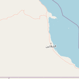
Map view of Wadi El Gamal National Park

Use this park location map to pinpoint Wadi El Gamal National Park in Egypt, understand its exact geographic position, and read its mapped placement within the surrounding landscape more clearly.

Pigeon | © OpenStreetMap contributors
Park atlas

Compare the diverse desert and coastal protected landscapes within Egypt's Red Sea Region geography.

Explore Nearby National Parks and Protected Areas Beyond Wadi El Gamal National Park

Continue your exploration of Egypt's protected areas by browsing additional national parks and conservation landscapes within the Eastern Desert and Red Sea Governorate, expanding your geographic understanding. Compare diverse desert environments, rugged mountain wildernesses, and unique coastal zones to trace the regional spread of Egypt's significant protected terrain.
National parkEgypt
Mapped park locations coincide#1 closest

Wadi El Gemal National Park National Park: Egypt's Protected Landscape and Geography

Explore the mapped boundaries and regional context of this Egyptian national park.

Wadi El Gemal National Park offers a detailed look into a significant protected natural area within Egypt. As a national park, it presents a specific landscape identity with clearly defined geographic boundaries that are invaluable for atlas-based exploration. Users can delve into the mapped terrain and understand the regional geographic context surrounding this protected land, enhancing their comprehension of Egypt's natural heritage.

Area
6,870 km²
Established
2003
Relief
Mountain
Scope
Mixed
National parkEgypt
About 59 km away#2 closest

Southeast

Gabal Elba National Park: Protected Landscape Geography in Egypt

Mapped terrain and regional context for this Egyptian national park.

Delve into the geographic identity of Gabal Elba National Park, a protected national park within Egypt. This resource supports atlas exploration by detailing its protected landscape, mapped boundaries, and how it fits into the broader regional geography. Understand the natural terrain and conservation significance of this distinct Egyptian protected area through detailed geographic information.

Area
35,600 km²
Established
1986
IUCN
II
Relief
Mountain
Protected areaEgypt
About 223 km away#3 closest

West

Saluga and Ghazal Protectorate Protected Area: Mapped Boundaries and Egyptian Geography

Explore the protected landscape and regional geographic setting.

Delve into the specifics of the Saluga and Ghazal Protectorate, a designated protected area contributing to Egypt's natural landscape mosaic. This entry focuses on its mapped boundaries and geographic significance, providing essential context for atlas exploration. Understand the protectorate's terrain and its place within the national geography for a structured discovery experience.

Established
1986
Relief
Lowland
Access
Easy access
Scope
Terrestrial
National parkSouth Sinai Governorate
About 388 km away#4 closest

North

Ras Muhammad National Park: South Sinai Protected Landscape and Geographic Atlas

Discover the mapped boundaries of this Egyptian national park.

Ras Muhammad National Park is a crucial protected area within the South Sinai Governorate, offering insights into Egypt's natural landscapes. This page facilitates an atlas-style exploration of the park, highlighting its geographic significance and protected status. Users can investigate its mapped terrain and understand its context within the regional geography of the Sinai Peninsula for structured geographic discovery.

Area
480 km²
Established
1983
Relief
Mixed relief
Climate
Arid
Protected areaSouth Sinai Governorate
About 440 km away#5 closest

North

Nabq Protected Area: South Sinai Governorate Protected Landscape and Regional Geography

Explore its mapped terrain and protected area context.

Nabq Protected Area offers a distinct view into Egypt's protected landscapes, situated within the South Sinai Governorate. This detailed page provides an atlas-style perspective on its geographic setting, allowing for structured exploration of its mapped boundaries and its role within the regional context. Understand the unique natural terrain and protected area characteristics that define this significant Egyptian site.

Area
600 km²
Established
1992
IUCN
VI
Relief
Mountain
National parkEgypt
About 477 km away#6 closest

North

Saint Katherine Protectorate National Park: Egypt's Protected Landscape and Geographic Identity

Mapped boundaries and regional terrain discovery for this Egyptian protected area.

Saint Katherine Protectorate is a key national park in Egypt, representing a significant protected landscape within the Sinai Peninsula. This page offers a detailed atlas view of its protected boundaries and geographic context. Users can explore its position within Egypt's broader geography and understand its role as a vital protected area for regional landscape study.

Established
1983
Relief
Mountain
Climate
Alpine
Access
Moderate access
Nature reserveSaudi Arabia
About 625 km away#7 closest

Northeast

Al-Khunfah Natural Reserve: Saudi Arabian Nature Reserve within the Nefud Desert Region

Mapped protected area and unique desert birdlife habitat.

Al-Khunfah Natural Reserve is a large nature reserve in Saudi Arabia, situated on the fringes of the distinctive Nefud Desert. This protected area plays a crucial role in conserving desert wildlife, with a notable focus on supporting diverse bird species within its arid ecosystems. Explore the mapped boundaries and landscape context of this significant protected territory, understanding its place within the broader geography of Saudi Arabia.

Area
19,339 km²
Established
1987
IUCN
VI
Relief
Lowland
Nature reserveSaudi Arabia
About 642 km away#8 closest

North

Al-Tubayq Natural Reserve: Protected Nature Reserve within Saudi Arabia's Geography

Mapped protected landscape and regional terrain context.

Al-Tubayq Natural Reserve represents a distinct protected natural area within the geography of Saudi Arabia. This detail page focuses on its identity as a nature reserve, providing an atlas-driven view of its mapped boundaries and its place within the broader regional landscape. Understand the protected territory and its environmental significance, offering a factual foundation for geographic discovery and conservation context.

Area
12,105 km²
Established
1989
Relief
Upland
Climate
Arid

Common questions about visiting, size, designation, and location context for Wadi El Gamal National Park

Wadi El Gamal National Park FAQs for park facts, access, geography, and protected area context

Find quick answers about Wadi El Gamal National Park, including protected-area facts, park geography, trail and visitor context, and how the park fits into its surrounding country and regional landscape.
MoriAtlas Explorer

Continue Your Protected Areas Search Across the Global Atlas

Deepen your exploration by continuing the structured search for national parks and protected areas worldwide. Utilize the comprehensive filtering capabilities to compare different conservation landscapes and refine your understanding of global park geography. Discover more about the distribution and characteristics of protected natural areas.

Global natural geography