
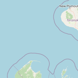
Viewpoints
Park geography
Analyzing the coastal terrain, regional boundaries, and physical landscape characteristics.
Geographic Profile and Mapped Boundaries of Abel Tasman National Park in Tasman District
This geographic profile details the spatial extent and natural features of Abel Tasman National Park. Covering 237.1 square kilometers within the Tasman District of New Zealand, the park encompasses diverse upland terrain, coastal capes, and temperate forest habitats. Data includes key natural landmarks and mapped boundary measurements.
Related tags
Coastal National ParkIsland EcosystemsMāori Heritage SiteNew Zealand Great WalksRestoration Ecology
New Zealand's smallest national park protecting a stunning coastal landscape shaped by centuries of Māori history and ongoing ecological restoration
Abel Tasman National Park
Abel Tasman National Park is New Zealand's smallest national park, covering 237.1 square kilometres at the northern tip of the South Island. The park occupies a distinctive coastal landscape between Golden Bay to the north and Tasman Bay to the east, characterized by forested hills, sheltered coves, golden sand beaches, and a chain of islands just offshore. Established in 1942 to commemorate the 300th anniversary of Dutch explorer Abel Tasman's 1642 visit, the park holds special significance as the site of first contact between European explorers and Māori. Unlike most of New Zealand's protected areas, this park bears the marks of extensive historical modification through early European settlement, making its restoration efforts particularly meaningful. The park's legendary Abel Tasman Coast Track ranks among the country's Great Walks, drawing visitors who trek along 60 kilometres of spectacular coastline between beach-fringed coves and forested headlands.
- Location
- New Zealand
- Park type
- National park
- Established
- 1942
- Area
- 237.1 km²
Location overview
Coastal and island geography within the Tasman District region
Geographic Position of Abel Tasman National Park in New Zealand
Abel Tasman National Park is situated entirely within New Zealand under the local jurisdiction of the Tasman District. It features designated coastal and island territory managed under a single regional authority.
- Countries
- New Zealand
- Regions
- Tasman District
- Primary location
- Tasman District
- Geographic setting
- Coastal · Island
Boundary and coordinates
Analyzing the 237.1 square kilometer spatial footprint and coordinates
Abel Tasman National Park Boundary Map and Geographic Extent
The mapped boundary outline provides essential spatial context for the protected landscape. Accompanying geospatial measurements detail the total land area, geographic center, and coordinate limits.
- Boundary area
- 240.9 km²
- Boundary perimeter
- 173.2 km
- Northernmost point
- 40.7808° S
- Southernmost point
- 40.999° S
- Easternmost point
- 173.0692° E
- Westernmost point
- 172.8323° E
- Geographic centre
- 40.9099° S, 172.9662° E
- North–south span
- 24.2 km
- East–west span
- 20 km
Terrain and natural features
Explore recorded upland terrain and internal geographical features
Abel Tasman National Park Terrain and Named Natural Features
Upland terrain classifications define the regional landscape across Abel Tasman National Park alongside recorded named natural features. Linked feature cards supply type classifications and spatial relationships for identified points within the protected area.
Selected named natural features
Peaks
Pisgah Hill
1,096 m
Capes
North Head
Beaches
Observation Beach
Peaks
Taupō Hill
205 m
Streams
Tregidga Creek
Environmental setting
Temperate climate zones, coastal habitats, and varied upland relief formations
Abel Tasman National Park Environmental Classification and Physical Setting
Recorded landscape features and habitat types frame the physical setting across temperate forest and coastal zones. Associated database categories connect specific environmental classifications to related atlas destinations.
- Relief
- Upland
- Climate
- Temperate
- Water
- Major water bodies
- Forest cover
- Partial forest
- Seasonality
- Year-round
Landscape features
Hills · Valleys · Rivers · Coast · Dunes · Islands · Beach · Waterfalls · Cave · Forest · Grassland
Habitat types
Coastal habitat · Wetland · Dune habitat · Temperate broadleaf forest · Shrubland · Montane forest
Park atlas
Compare New Zealand's diverse coastal and terrestrial protected areas, mapping their unique geography and conservation focus.
Explore National Parks and Protected Areas Near Abel Tasman National Park, New Zealand
Browse a curated selection of national parks and protected areas that share geographic features or conservation goals with Abel Tasman National Park, extending your exploration across New Zealand's South Island. Compare mapped coastal landscapes, island ecosystems, and terrestrial reserves to deepen your understanding of the country's interconnected protected-area network and regional park geography.
National parkWest Coast Region
2.9 km away#1 closest
Southwest

Kahurangi National Park: A National Park of Ancient Geology and Diverse Protected Landscapes in New Zealand
Explore the mapped natural terrain and regional geographic context.
Kahurangi National Park is distinguished by its extraordinary geological diversity, representing New Zealand's finest Paleozoic rock sequence and expansive karst features. Covering a vast area in the West Coast Region, it protects a remarkable array of natural landscapes, from coastal cliffs and nikau palm forests to alpine tussock basins and deep gorges. This national park is crucial for understanding New Zealand's natural heritage, offering a rich tapestry of mapped terrain and protected biodiversity for dedicated geographic exploration.
- Area
- 5,193 km²
- Established
- 1996
- IUCN
- II
- Relief
- Mixed relief
Protected landscapeNew Zealand
About 38 km away#2 closest
West
North-west Nelson Forest Park: Exploring the Tasman Region Protected Landscape Boundaries
A mapped overview of scattered conservation blocks in South Island, New Zealand.
North-west Nelson Forest Park provides an atlas-style perspective on the evolution of public conservation land in the Tasman region. Once a continuous wilderness, the remaining forest park is characterized by a series of excluded parcels that now border the Kahurangi National Park. This site documents the terrain and geographic distribution of these disparate forest blocks, offering insight into the legacy of land management and protected area formation within the northern South Island.
- Established
- 1970
Protected landscapeMarlborough Region
40 km away#3 closest
Southeast
Mount Richmond Forest Park: Geography and Protected Landscapes in the Marlborough Region
Expansive native bush and mountain peak terrain
Mount Richmond Forest Park stands as one of the largest protected forest areas on the South Island of New Zealand. Dominated by dense native bush and rugged subalpine ridges, the park offers a complex topography of river valleys and high-altitude peaks, including its namesake Mount Richmond. It serves as a vital conservation landscape and a core segment of the regional geography between Nelson and the Marlborough district.
- Area
- 1,659 km²
- Established
- 1977
- Relief
- Mountain
- Scope
- Terrestrial
Marine protected areaWest Coast Region
61 km away#4 closest
West
Kahurangi Marine Reserve: Protected Marine Landscapes and West Coast Geography
Mapped coastal reefs, nīkau forest margins, and subtidal habitats
Located in New Zealand's West Coast Region, Kahurangi Marine Reserve protects 16 kilometres of coastline and extends five kilometres offshore. The reserve is defined by its layered marine profile, ranging from boulder-strewn beaches to complex rocky reefs and expansive mud and sand seabeds. It serves as a vital protected counterpart to Kahurangi National Park, fostering habitats for Hector's dolphins and diverse reef communities within its remote and rugged geography.
- Area
- 84.19 km²
- Established
- 2014
- Relief
- Lowland
- Climate
- Temperate
Nature reserveNew Zealand
About 69 km away#5 closest
East
Maud Island Nature Reserve: Geographic Overview and Protected Coastal Landscape
A pivotal conservation sanctuary in the Marlborough Sounds region
Maud Island represents a critical protected area in the Pelorus Sound of New Zealand. Defined by 320 hectares of forested, hilly terrain and a unique narrow isthmus, the island serves as a foundational refuge for species recovery. Its sheltered maritime setting makes it a key feature of the Marlborough Sounds geography and an essential location for scientific ecological research.
- Area
- 3.2 km²
- Established
- 1971
- Relief
- Upland
- Climate
- Temperate
Nature reserveMarlborough Region
About 82 km away#6 closest
East
Stephens Island (New Zealand) Nature Reserve: Geography and Protected Land Overview
Maritime sanctuary and ecological refuge in Marlborough Region
Stephens Island (New Zealand) acts as a rugged, compact island refuge in the Cook Strait, defined by steep terrain rising to 283 metres. As a critical nature reserve managed by Ngāti Koata and the Department of Conservation, this site offers profound insights into isolated island ecosystems, evolutionary endemic species, and the geological processes of the Maitai Group.
- Area
- 1.5 km²
- Established
- 1966
- Relief
- Upland
- Climate
- Temperate
National parkNew Zealand
87 km away#7 closest
South
Nelson Lakes National Park: Alpine Geography and Glacial Lakes Atlas
Explore New Zealand's protected mountain terrain and natural landscapes.
Nelson Lakes National Park provides a deep dive into a dramatic alpine environment situated at the northern edge of New Zealand's Southern Alps. This national park is characterized by its striking glacial lakes, Rotoiti and Rotoroa, and the extensive mountain ranges that surround them, offering a rich context for understanding protected land distribution. Explore the park's mapped geography, its distinct beech forest ecosystems, and the rugged natural terrain that makes it a significant feature within the broader South Island landscape.
- Area
- 1,018.8 km²
- Established
- 1956
- IUCN
- II
- Relief
- Mountain
Marine protected areaMarlborough Region
102 km away#8 closest
East
Long Island-Kokomohua Marine Reserve: Mapped Geography and Protected Reef Systems
Explore marine boundaries in the Marlborough Region
Located at the entrance to Queen Charlotte Sound, Long Island-Kokomohua Marine Reserve encompasses significant island and submerged reef features. This protected area serves as an essential site for understanding coastal ecosystem restoration, featuring varied terrain from shallow near-shore reefs to deeper rocky pinnacles that support diverse marine populations.
- Area
- 6.19 km²
- Established
- 1993
- Relief
- Lowland
- Climate
- Temperate
MoriAtlas Explorer
Continue Exploring Abel Tasman National Park's Coastal Geography and Protected Boundaries
Further your understanding of Abel Tasman National Park by delving into its specific geographic features and protected area context. Examining the mapped terrain and landscape elements reveals its ecological importance and historical significance. This exploration helps contextualize the park within New Zealand's network of protected lands, offering deeper insights for any atlas enthusiast focused on coastal environments and conservation efforts.
Browse next
Global natural geography
Explore related park routes
Explore MoriAtlas Global ParksBrowse All MoriAtlas ParksGlobal Park Map DiscoveryMoriAtlas: Browse All CountriesBrowse All MoriAtlas ContinentsNational Park Environment AtlasGrand Canyon National Park AtlasYellowstone National Park AtlasYosemite National Park Atlas and GeographySerengeti National Park AtlasGalápagos National Park Protected LandscapeBanff National Park Geography and AtlasKruger National Park Atlas EntryUluṟu-Kata Tjuṯa National Park AtlasExplore Uluru-Kata Tjuta National Park GeographyPlitvice Lakes National Park AtlasFiordland National Park Protected LandscapeGreat Smoky Mountains National Park AtlasAfghanistan National Parks and Protected AreasAlbania National Parks and Protected AreasAlgeria National Parks and Protected AreasAmerican Samoa National Parks and Protected AreasAndorra National Parks and Protected AreasAngola National Parks and Protected AreasAntarctica National Parks and Protected AreasAntigua and Barbuda Park List