Cave entrances
Andris-lyuka
536 m

A structured profile of the environmental landscape and administrative reach of this protected area.
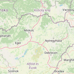
Detailed examination of the geographic footprint of Aggtelek National Park in Northern Hungary. This profile captures the 198.92 square kilometer extent and defines the park through its temperate climate, karst landscape, and diverse habitat classifications including forest, grassland, and wetland zones.
Hungary's premier karst landscape protecting Europe's longest stalactite cave system
Aggtelek National Park is Hungary's fourth national park, established in 1985 to protect the extraordinary karst landscapes of the Aggtelek Karst region in Northern Hungary. The park encompasses approximately 199 square kilometers of limestone terrain containing one of Europe's most significant cave systems, with over 280 caves of varying sizes and configurations. The most remarkable feature is the Baradla-Domica cave system, spanning 26 kilometers with 8 kilometers extending into Slovakia, making it the longest active stream cave in the temperate zone of Europe. The park was designated a UNESCO World Heritage Site in 1995, recognized as a transboundary site with the Slovak Karst caves, representing one of the most important karst landscapes in the world. Beyond its underground wonders, the park protects diverse surface formations including karst plateaus, sinkholes, dolines, and karst fields, alongside rich forest ecosystems and wildlife habitats.
Mapping the regional placement and national territory within Hungary
Spatial dimensions, center coordinates, and total protected area calculations
Explore recorded cave entrances, springs, valleys, and peaks within the protected landscape
Cave entrances
536 m
Cave entrances
Cave entrances
Natural springs
Cave entrances
502 m
Natural springs
Temperate climate zones, mixed relief terrain, and recorded landscape features
Mountains · Hills · Valleys · Forest · Cave · Karst · Wetland
Temperate broadleaf forest · Grassland · Wetland · Riverine habitat
Trace the regional spread of protected landscapes, comparing Aggtelek National Park's unique karst terrain with adjacent natural areas.

Southeast

A mapped overview of the Aggtelek Karst subterranean systems.
Baradla Cave functions as a protected natural monument, offering a comprehensive look at the geological processes within the Aggtelek Karst. The system is defined by its seven-kilometer main passage, giant chambers, and extraordinary variety of stalactite and stalagmite formations, revealing how climate and water have shaped the underground landscape over millennia.
North

Explore protected terrain and mapped underground wonders in Košice Region.
Slovak Karst National Park offers an unparalleled glimpse into a dynamic karst environment. As a designated national park and UNESCO Biosphere Reserve, it preserves a significant concentration of caves, dramatic limestone formations, and rugged canyons within its territory in southeastern Slovakia. This atlas-focused presentation highlights the park's distinctive geology, mapped landscape features, and its importance as a protected natural area within the broader geography of the Košice Region. Understand the park's surface topography and its world-renowned subterranean realms.
South
Explore mapped boundaries and unique protected landscapes.
Bükk National Park, a protected national park located in Borsod-Abaúj-Zemplén County, Hungary, is recognized for its immense karst landscape. This park offers a significant focus for atlas exploration, with its extensive cave systems, limestone plateaus, and ancient forests providing a unique geographic context for understanding protected areas. Discover the diverse terrain and geological features that define this expansive Hungarian national park.
North
Explore the boundaries and terrain of this national park.
Investigate Slovak Paradise National Park, a designated national park situated within Slovakia's Košice Region. This detailed entry provides essential context for understanding its protected landscape features, mapped geographic distribution, and role within regional atlas exploration. Discover its unique terrain and boundaries to build a comprehensive view of Slovak conservation areas.
Northwest
Explore mapped boundaries, caves, and endemic flora in Banská Bystrica Region.
Muránska planina National Park represents a significant protected landscape in central Slovakia's Banská Bystrica Region, defined by its extensive karst topography. This national park encompasses a limestone and dolomite plateau rich with geological wonders, including over 150 caves, sinkholes, and karst springs. The unique contrast between the flat plateau surface and the sharp, rocky ravines showcases a dramatic natural terrain. Explore the park's mapped boundaries and its remarkable biodiversity, highlighted by 35 endemic species and rare Tertiary relict flora like Daphne arbuscula, making it a key destination for atlas-based geographic discovery.

Northwest
Explore mapped terrain and regional geographic context.
The Low Tatras National Park represents Slovakia's largest protected area, encompassing the entirety of the Low Tatras mountain range. Its landscape is defined by dramatic altitudinal diversity, from alpine summits like Ďumbier to extensive forest zones and significant karst formations with notable cave systems. This page provides detailed geographic context and map-based discovery for the park's protected boundaries and its ecological significance within the Carpathian region.

Northwest
Protected Mountain Terrain in the Carpathian Range
Examine the geographic framework of Tatra National Park, a significant protected area in Slovakia defined by dramatic glacial valleys, over three hundred caves, and high-altitude mountain ecosystems. This authoritative entry provides a detailed look at the park's alpine boundaries, hydrological networks, and role as a transboundary biosphere reserve in the Carpathian Mountains.
Southeast
Explore the unique geography and mapped park boundaries of Hungary's first national park.
Hortobágy National Park is a monumental protected area in Eastern Hungary, recognized globally as the first national park established in the country and a UNESCO World Heritage site. This vast expanse of semi-natural grassland, known as the puszta, stretches across approximately 74,820 hectares, embodying over four millennia of pastoral traditions. The park's landscape is characterized by alkaline soils and sweeping horizons, offering a unique ecosystem with significant avian populations and preserved cultural landmarks. MoriAtlas provides structured geographic context and mapped details to understand this exceptional protected landscape.
Deepen your understanding of Aggtelek National Park's unique karst terrain and mapped boundaries. Use MoriAtlas to uncover its place within the broader geographic and protected landscape context of the region.