Mori Atlas logo
National parkAlerce Andino National Park

Discover the mapped boundaries and geographic context of this important national park.

Alerce Andino National Park: A Protected Landscape in Chile's Los Lagos Region

Alerce Andino National Park stands as a significant protected area within the vast geography of Chile's Los Lagos Region. This page offers an in-depth look at Alerce Andino National Park, detailing its role as a national park and providing essential context for understanding its protected landscape and mapped terrain. Explore the geographic identity of this conservation area and its placement within the broader southern Chile region.

National ParkTemperate RainforestOld-Growth ForestFitzroyaAndes MountainsGlacial Lakes

Alerce Andino National Park

National park

Park overview

Structured park overview, official facts, and landscape profile for Alerce Andino National Park

Alerce Andino National Park park facts, protected area profile, and essential visitor context
Review the core facts for Alerce Andino National Park, including designation, size, terrain, visitor scale, habitats, and operating context in one park-focused overview.

About Alerce Andino National Park

Alerce Andino National Park represents one of Chile's most important protected areas for temperate forest conservation. The park's core identity centers on the Fitzroya cupressoides, a species endemic to the southern Andes and one of the longest-lived trees in the world, with specimens known to exceed 3,000 years of age. These ancient forests dominate the landscape, appearing both in pure stands and mixed with other species of the temperate rainforest. The park's terrain is characterized by mountainous relief, deep valleys, and extensive wetland areas that have been shaped by glacial processes. Water is a defining feature of the park, with more than fifty lakes and numerous ponds scattered throughout the landscape, fed by precipitation from the nearby mountains and creating a complex hydrological network that drains toward the Reloncaví Estuary. The protected area serves as a crucial ecological corridor within the larger Southern Andes temperate rainforest ecosystem, connecting coastal and mountain environments and supporting the movement of wildlife species throughout the region. The park's location in the transition zone between the Andes and the coastal ranges creates unique ecological conditions that support high biodiversity and distinctive plant communities.

Quick facts and research context for Alerce Andino National Park

Alerce Andino National Park is located in the Los Lagos Region of Chile within the Andes mountains. The park covers approximately 393 square kilometers and contains over fifty lakes and natural ponds. It was established in November 1982 under Chilean law D.S. N° 735 of the Ministry of National Assets. The park is part of the Southern Andes Temperate Rainforest Biosphere Reserve. Management is handled by CONAF, Chile's National Forestry Corporation. The nearest major city is Puerto Montt, about 46 kilometers away.

Park context

Deeper park guide and search-rich context for Alerce Andino National Park

Alerce Andino National Park history, landscape, wildlife, and travel context
Explore Alerce Andino National Park through its history, landscape character, ecosystems, wildlife, conservation priorities, cultural context, and seasonal travel timing in a structured park guide built for atlas discovery and search intent.

Why Alerce Andino National Park stands out

Alerce Andino National Park is best known for its remarkable Fitzroya cupressoides forests, locally called alerce. These ancient conifers can reach heights exceeding 40 meters and form one of the most extensive and well-preserved alerce forest ecosystems on the planet. The park protects approximately 20,000 hectares of alerce-dominated forest, making it a critical sanctuary for this slow-growing and long-lived species. The combination of pristine alerce forests, numerous glacial lakes, and the dramatic backdrop of the Andes creates one of Chile's most visually stunning and ecologically significant protected landscapes.

Alerce Andino National Park history and protected-area timeline

Alerce Andino National Park was officially established on November 17, 1982, through the issuance of Decree D.S. N° 735 by Chile's Ministry of National Assets. The creation of this protected area reflected growing recognition of the urgent need to conserve Chile's remaining old-growth alerce forests, which had faced significant pressure from logging and land conversion throughout the twentieth century. The establishment of the park came during a period of increased environmental awareness in Chile and aligned with the broader development of the country's national park system under the management of CONAF. Prior to formal protection, portions of the alerce forest had experienced selective logging, but the ecological significance of the remaining stands prompted governmental action to secure permanent conservation. The park's boundaries were defined to include not only the core alerce forest areas but also the surrounding lake systems and watershed areas that contribute to the ecological integrity of the protected landscape.

Alerce Andino National Park landscape and geographic character

The landscape of Alerce Andino National Park is defined by the interplay of mountainous terrain, extensive forest cover, and abundant water bodies. The Andes mountains form the eastern backdrop, with elevations rising sharply from the lake-filled valleys below. The terrain exhibits the characteristic features of glacial carving, with U-shaped valleys, moraine deposits, and cirque basins that now hold many of the park's lakes. The Reloncaví Estuary marks the park's southern and eastern boundary, creating a marine-influenced environment where freshwater meets the sea. To the west, the Reloncaví Sound separates the park from the coastal zones, while Chapo Lake marks the northern extent of the protected area. Throughout the park, the terrain ranges from gentle lake shores to steep mountain slopes, with elevation changes creating diverse microclimates and vegetation zones. The forest canopy is dominated by the towering alerce, but the landscape also includes open areas around lakes, wetland margins, and the clearer waters of glacial streams that cascade through the terrain.

Alerce Andino National Park ecosystems, habitats, and plant life

The ecological character of Alerce Andino National Park is shaped by its location within the Southern Andes Temperate Rainforest biome, one of the world's most distinctive and biodiverse forest ecosystems. The dominant feature is the Fitzroya cupressoides forest, which covers approximately 20,000 hectares within the park and represents one of the largest remaining tracts of this species. These forests thrive in the high-rainfall environment of the region, where annual precipitation supports dense vegetation and sustained moisture levels. The alerce trees, which can live for millennia, create a complex forest structure with towering emergents, a diverse mid-story, and a rich understory of ferns, shrubs, and epiphytic plants. The park's numerous lakes and ponds add to the ecological diversity, providing aquatic habitats and influencing the moisture regime of surrounding forests. The combination of elevation gradients, water bodies, and forest types creates a mosaic of habitats that support the park's biodiversity.

Alerce Andino National Park wildlife and species highlights

Alerce Andino National Park provides habitat for several notable mammal species that are characteristic of Chile's southern forests. The pudú, a small deer species and one of the smallest deer in the world, inhabits the forest understory and is commonly encountered within the park boundaries. The monito del monte, a small marsupial unique to the southern Andes, also occupies the park's forests and represents an important component of the region's faunal diversity. The park is also home to larger predators including pumas, which range through the forested terrain, and güiñas (kodkod), a small wild cat species that hunts in the forest canopy and understory. Additional mammalian species include the chingue, a type of skunk that forages in the undergrowth. The extensive lake system supports waterfowl and other bird species, while the forest canopy provides habitat for various songbirds and raptors. The combination of old-growth forest, younger successional areas, wetlands, and aquatic environments creates diverse habitat conditions that support this community of species.

Alerce Andino National Park conservation status and protection priorities

Alerce Andino National Park plays a critical role in the conservation of one of the world's most ancient and ecologically significant tree species. The Fitzroya cupressoides has been heavily impacted by historical logging throughout its range, making protected areas like this park essential for the survival of wild populations. The park is integrated into the Southern Andes Temperate Rainforest Biosphere Reserve, connecting it to broader regional conservation efforts that aim to protect the entire ecosystem rather than isolated fragments. The protection of the alerce forests also conserves the associated biodiversity that depends on old-growth forest conditions, including the many species that require the specific habitat structures provided by ancient trees. The network of lakes and the estuarine environment add additional conservation dimensions, protecting watershed ecosystems and the species that depend on aquatic habitats. The park's management by CONAF ensures ongoing protection and monitoring, though challenges related to visitor impact, boundary issues, and climate change effects on the forests require continued attention.

Alerce Andino National Park cultural meaning and human context

The park exists within a region that has been inhabited by indigenous peoples of the Mapuche culture for centuries, though the specific cultural history of the park's immediate area is not extensively documented in available sources. The name alerce itself derives from the local common name for Fitzroya cupressoides, a tree that held significance in traditional uses and continues to be recognized as an important natural landmark in Chilean culture. The broader Los Lagos Region has a history of settlement that includes both indigenous communities and more recent Chilean and European immigrant populations. The relationship between local communities and the forest landscape has evolved over time, from traditional resource use to contemporary appreciation of the area's conservation and recreational value.

Top sights and standout views in Alerce Andino National Park

The ancient Fitzroya (alerce) forests represent the crown jewel of Alerce Andino National Park, offering visitors the chance to walk among trees that have been growing for thousands of years. The park's more than fifty lakes, including Laguna Sargazo and the waters of Chapo Lake, provide scenic beauty and recreational opportunities in a setting of remarkable naturalness. Waterfalls such as those along the Chaicas River cascade through the forest, adding to the visual diversity of the landscape. The network of trails, including paths to the Rodal area, allows visitors to experience the forest ecosystem directly. The combination of old-growth forest, glacial lakes, mountain terrain, and the proximity to the Reloncaví Estuary creates a complex and rewarding landscape for exploration. The park's location relatively close to Puerto Montt makes it accessible for visitors seeking to experience the natural heritage of Chile's southern forests.

Best time to visit Alerce Andino National Park

Alerce Andino National Park can be visited throughout the year, though the experience varies significantly with the seasons. The summer months of December through February typically offer the most stable weather conditions and longer daylight hours, making this the peak visiting period. However, the park's temperate rainforest climate means that rain is possible in any season, and visitors should be prepared for variable conditions. The winter months bring cooler temperatures and increased precipitation, but also offer the opportunity to experience the forest in its quieter, more moody atmosphere. The shoulder seasons of spring and autumn provide intermediate conditions and may offer a balance between weather reliability and reduced crowds. Regardless of when visiting, the essential character of the alerce forests remains impressive, and the experience of walking among these ancient trees transcends seasonal considerations.

Park location guide

Geography guide, regional context, and park location map for Alerce Andino National Park

Alerce Andino National Park park geography, regions, and map view in Chile
Understand where Alerce Andino National Park sits in Chile through a broader geographic reading of the surrounding landscape, nearby location context, and its mapped position within the national park landscape.

How Alerce Andino National Park fits into Chile

Chile is a presidential republic in western South America, extending as a narrow strip along the western edge of the continent between the Andes Mountains and the Pacific Ocean. It is the southernmost country in the world and the closest to Antarctica. The country is bordered by Peru, Bolivia, and Argentina, and administers several Pacific islands including Easter Island. Chile is a major copper producer and has a population of approximately 19.6 million.

Wider geography shaping Alerce Andino National Park in Chile

Chile occupies a narrow strip of land along the western edge of South America, extending approximately 4,300 km north to south but only about 350 km east to west at its widest point. The country is sandwiched between the Andes Mountains to the east and the Pacific Ocean to the west. It shares borders with Peru to the north, Bolivia to the northeast, and Argentina to the east. Southern Chile borders the Drake Passage. Chile also administers several Pacific islands including Juan Fernández Islands, Isla Salas y Gómez, Desventuradas Islands, and Easter Island, plus the Chilean Antarctic Territory.

Map view of Alerce Andino National Park

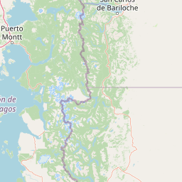
Use this park location map to pinpoint Alerce Andino National Park in Chile, understand its exact geographic position, and read its mapped placement within the surrounding landscape more clearly.

Pigeon | © OpenStreetMap contributors

Location context for Alerce Andino National Park

Los Lagos Region
Park atlas

Compare nearby national parks and trace the protected landscapes, from ancient forests to glacial lakes, across Southern Chile.

Alerce Andino National Park: Discover Other Protected Areas in Southern Chile's Andes
Browse a curated selection of national parks and protected areas near Alerce Andino National Park, including other significant temperate rainforests, dramatic mountain peaks, and numerous glacial lakes in the Los Lagos Region. Comparing these protected landscapes provides valuable geographic context for understanding the broader conservation efforts and diverse terrain of Southern Chile.
National parkLos Lagos Region

Hornopirén National Park: Mapped Protected Landscape and Geographic Identity

Explore the national park's mapped boundaries and regional context.

Hornopirén National Park serves as a crucial protected landscape within Chile's Los Lagos Region. This dedicated park page offers detailed insight into its geographic setting, emphasizing mapped boundaries and its identity as a national park. Users can explore how Hornopirén National Park contributes to the regional geography and protected-area framework, providing a grounded point for landscape discovery.

Area
482 km²
Established
1988
IUCN
II
Relief
Mountain
National parkLos Lagos Region

Vicente Pérez Rosales National Park: Protected Landscape & Regional Geography Atlas

Mapped park boundaries and natural terrain in Los Lagos Region.

Delve into the protected area identity of Vicente Pérez Rosales National Park, a significant national park situated in Chile's Los Lagos Region. This detailed exploration focuses on understanding the park's geographic setting, its mapped landscape features, and its contribution to the regional atlas of protected territories. Discover the natural terrain and boundary context that define this unique Chilean landscape.

Area
2,530 km²
Established
1926
IUCN
II
Visitors
332.3K annual
Watercolor illustration showing a lake surrounded by forested hills and mountains
National parkChubut Province

Lago Puelo National Park: A Unique Protected Landscape at the Intersection of Biomes

Explore its glacial terrain and Andean-Patagonian geographic context.

Lago Puelo National Park, located in Argentina's Chubut Province, stands out as a significant protected area due to its remarkable ecological diversity. This park is distinguished by its rare transition zone where the Patagonian forest converges with the Andean steppe, incorporating flora typically found in the Valdivian temperate rainforest. The mountainous landscape, carved by glaciers, features the striking turquoise waters of Puelo Lake and surrounding river systems. Understanding Lago Puelo National Park's geography provides insight into the complex natural systems of Patagonia and its unique protected biomes.

Area
276.74 km²
Established
1971
IUCN
II
Relief
Mountain
National parkRío Negro Province

Nahuel Huapi National Park: Protected Area Landscape and Geographic Context in Río Negro

Explore mapped natural terrain and park boundaries within Patagonia.

Nahuel Huapi National Park is a crucial protected area offering a deep dive into the Patagonian landscape. Situated in Argentina's Río Negro Province, this national park provides a detailed view of mapped natural terrain and its environmental context. Users can explore the park's geographic identity and protected boundaries, making it an essential stop for understanding the regional geography and conservation significance of this part of South America.

Area
7,050 km²
Established
1934
IUCN
II
Relief
Mountain
Watercolor illustration of a mountain range with a lake and forested hills in soft green, pink, and beige tones
National parkLos Lagos Region

Puyehue National Park: Mapped Boundaries and Volcanic Landscape in Los Lagos Region

Explore Chile's dramatic Andean protected area.

Puyehue National Park is a key protected area in the Los Lagos Region of Chile, recognized for its distinctive volcanic landscapes and geothermal features. This detail page offers an atlas-centric view, highlighting the park's mapped boundaries, the terrain shaped by volcanoes like Puyehue, and its ancient temperate rainforest ecosystems. Understand its geographic context within the Andes and its significance as a protected national park.

Area
1,070 km²
Established
1941
IUCN
II
Visitors
133K annual
National parkNeuquén Province

Los Arrayanes National Park: Neuquén Province's Protected Arrayán Forest Atlas

Explore the ancient arrayán forest and mapped terrain.

Los Arrayanes National Park, nestled in Neuquén Province, is celebrated for its exceptional arrayán forest, one of the world's most concentrated stands of Luma apiculata. This protected area showcases a unique landscape where ancient, gnarled trees with striking cinnamon bark thrive on the Quetrihué Peninsula, overlooking Nahuel Huapi Lake. Its protected status ensures the preservation of this botanical marvel, offering a distinct geographical and ecological profile within the Patagonian region.

Area
17.53 km²
Established
1971
IUCN
II
Relief
Upland
National parkLos Lagos Region

Chiloé National Park: National Park Discovery and Mapped Boundaries in Los Lagos Region

Explore its unique protected landscape and regional geography.

Chiloé National Park represents a significant protected natural area within the Los Lagos Region of Chile. This detailed page offers an atlas-centric view, focusing on the park's mapped boundaries, its place in the regional geography, and the overall protected landscape character. Gain structured insight into this important component of southern Chile's conservation lands, ideal for geographic exploration and atlas context.

Area
430.57 km²
Established
1983
IUCN
II
Visitors
33.6K annual
Watercolor painting depicting mountains, a lake, and grassy shoreline
National parkArgentina

Los Alerces National Park: Ancient Alerce Forests and Glacial Terrain in Argentina

Discover the park's protected landscape and regional geography.

Los Alerces National Park in Argentina is a globally significant protected area, celebrated for its ancient alerce forests, some of the longest-living trees on Earth. This national park showcases a dramatic landscape shaped by glaciers, featuring a series of interconnected lakes and rugged Andean terrain. Explore the unique ecosystem and mapped geography of this UNESCO World Heritage site to understand its profound natural and conservation value.

Area
2,599 km²
Established
1937
IUCN
II
Relief
Mountain

Common questions about visiting, size, designation, and location context for Alerce Andino National Park

Alerce Andino National Park FAQs for park facts, access, geography, and protected area context
Find quick answers about Alerce Andino National Park, including protected-area facts, park geography, trail and visitor context, and how the park fits into its surrounding country and regional landscape.
MoriAtlas Explorer

Continue Your Protected Areas Search Across the Global Atlas

Deepen your exploration by continuing the structured search for national parks and protected areas worldwide. Utilize the comprehensive filtering capabilities to compare different conservation landscapes and refine your understanding of global park geography. Discover more about the distribution and characteristics of protected natural areas.

Global natural geography