Mori Atlas logo
National parkAltadighi National Park

Discover the mapped boundaries and geographic context of this unique national park.

Altadighi National Park: Wetland Reserve and Protected Landscape in Naogaon District

Altadighi National Park, established as a national park in Bangladesh in 2011, represents a significant protected wetland landscape within Naogaon District. This park is distinguished by its expansive reservoir, the largest in the region, which forms the ecological heart of the reserve and supports a unique array of aquatic and terrestrial habitats. Situated in the northern frontier, Altadighi National Park offers a focal point for understanding protected area geography and landscape diversity in Bangladesh.

wetland reservenature reserveprotected areaIUCN Category IVBangladesh protected areaDhamoirhat

Altadighi National Park

National park

Park overview

Structured park overview, official facts, and landscape profile for Altadighi National Park

Altadighi National Park park facts, protected area profile, and essential visitor context
Review the core facts for Altadighi National Park, including designation, size, terrain, visitor scale, habitats, and operating context in one park-focused overview.

About Altadighi National Park

Altadighi National Park represents an important addition to Bangladesh's network of protected areas, established in 2011 to conserve the unique wetland and terrestrial habitats found in the country's northwestern plateau region. The park is located in Dhamoirhat Upazila, an area characterized by rolling terrain and agricultural landscapes that differ from the extensive floodplains typical of central and southern Bangladesh. The presence of a substantial reservoir, the largest in Naogaon District, distinguishes this park from many other protected areas in the country and creates a focal point for biodiversity. The Bangladesh Forest Department manages the park through its Paikbandha Forest Range, overseeing both conservation and sustainable management of the area's natural resources. The park's proximity to the India border places it within a broader ecological landscape that includes cross-border wildlife movements and shared conservation considerations.

Quick facts and research context for Altadighi National Park

Altadighi National Park spans 264.12 hectares in Naogaon District, northwestern Bangladesh, near the border with India. The park was established in December 2011 and is classified as an IUCN Category IV protected area, reflecting its role as a habitat and species management area. A defining feature is the large reservoir covering approximately 55.46 acres, the largest in the district, which creates a wetland environment distinct from the more floodplain-dominated landscapes found in other Bangladeshi protected areas. The park falls under the management of the Bangladesh Forest Department's Paikbandha Forest Range.

Park context

Deeper park guide and search-rich context for Altadighi National Park

Altadighi National Park history, landscape, wildlife, and travel context
Explore Altadighi National Park through its history, landscape character, ecosystems, wildlife, conservation priorities, cultural context, and seasonal travel timing in a structured park guide built for atlas discovery and search intent.

Why Altadighi National Park stands out

Altadighi National Park is most notably recognized for its significant reservoir and associated wetland ecosystems in a region where such habitats are relatively uncommon. The reservoir serves as a central ecological feature, supporting waterfowl, aquatic species, and riparian vegetation within the protected area. The park also provides protection for several wildlife species including junglefowl, golden jackal, civet, jungle cat, and monitor lizard. Its location in the northwestern frontier region of Bangladesh, near the international border, gives it additional significance as a transboundary conservation area.

Altadighi National Park, Naogaon
Altadighi National Park is located in Dhamoirhat sub-district, Naogaon district, near the India-Bangladesh border.

Altadighi National Park history and protected-area timeline

Altadighi National Park was officially declared as a national park by the Government of Bangladesh on 14 December 2011, representing a relatively recent addition to the country's protected area network. The designation followed recognition of the area's ecological significance, particularly the value of its wetland habitats and the reservoir ecosystem. Prior to national park status, the area existed within the broader forest range system under the Bangladesh Forest Department. The establishment reflected growing governmental attention to conserving non-floodplain ecosystems in Bangladesh, which have historically received less protection than the extensive riverine and coastal wetlands that dominate the country's protected area landscape.

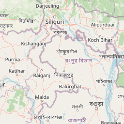
Altadighi National Park landscape and geographic character

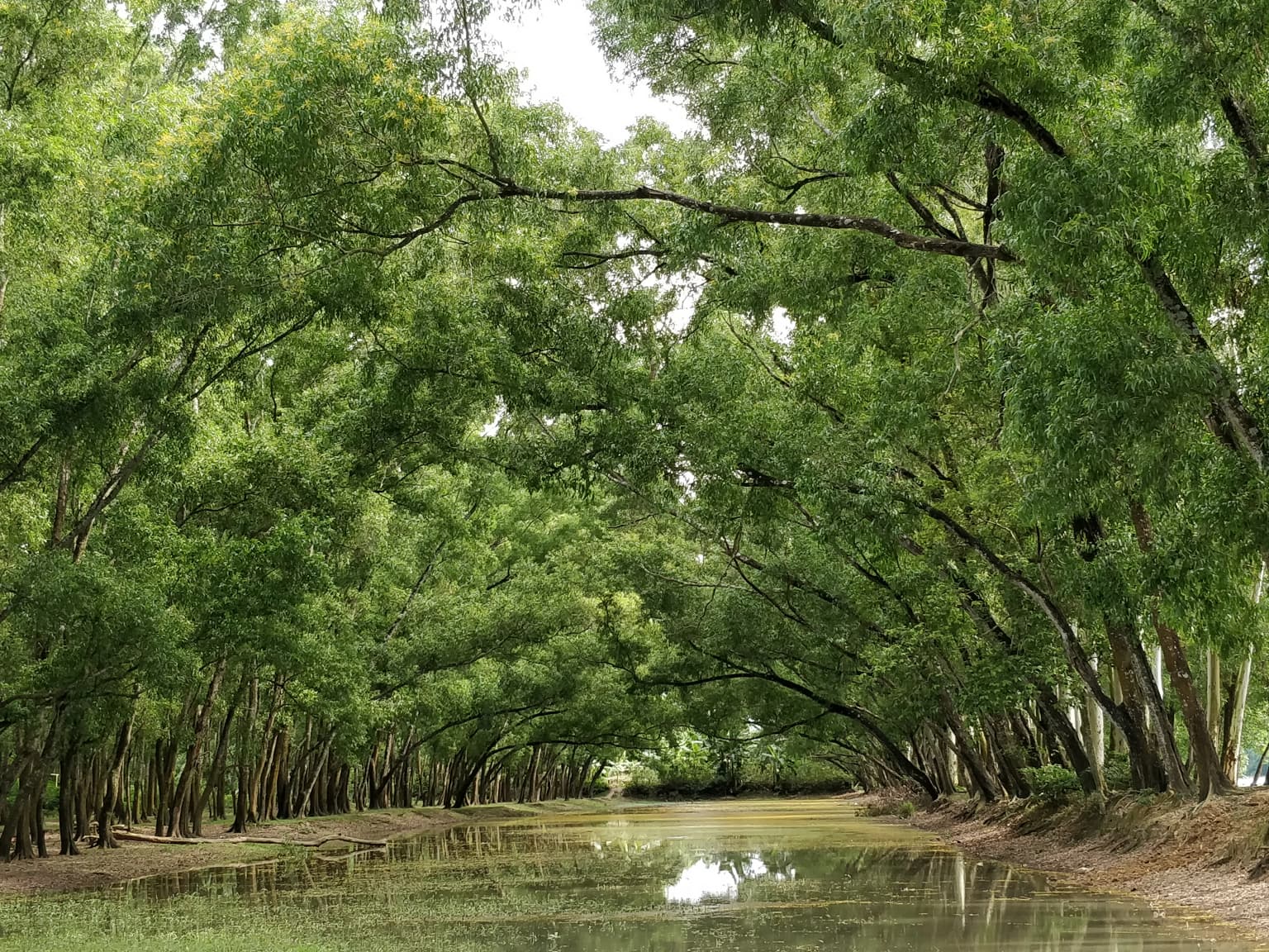
The landscape of Altadighi National Park is characterized by its central reservoir and surrounding wetland and terrestrial terrain. Unlike the vast deltaic floodplains that define much of Bangladesh, the Naogaon District features more undulating topography, and the park encompasses this varied terrain within its 264-hectare boundary. The reservoir, spanning approximately 55.46 acres, serves as the visual and ecological centerpiece of the park, creating open water habitat surrounded by vegetated margins. The surrounding lands include both wetland areas that receive overflow from the reservoir and drier transitional zones supporting different vegetation types.

Altadighi National Park ecosystems, habitats, and plant life

The ecological character of Altadighi National Park centers on its wetland habitats, with the large reservoir providing the primary ecological engine for the area. The reservoir and associated wetlands support aquatic vegetation, provide foraging habitat for waterbirds, and maintain moisture levels that sustain riparian plant communities. The mix of open water, marshy margins, and surrounding terrestrial areas creates a habitat gradient that supports diverse species assemblages. This wetland character distinguishes the park within the context of Bangladeshi protected areas, where floodplain and coastal ecosystems are more commonly represented.

Altadighi National Park wildlife and species highlights

The fauna of Altadighi National Park includes several species adapted to wetland and forest-edge habitats. Bird species present in the park include junglefowl, which thrive in the vegetated margins surrounding the reservoir. Mammalian species documented within the park include golden jackal, civet, and jungle cat, each utilizing different habitat types within the protected area. Reptile diversity includes monitor lizard, which can be found near water bodies and in the surrounding vegetation. The reservoir likely supports additional fish species and aquatic fauna, though detailed species inventories are limited in the available source material.

Altadighi National Park conservation status and protection priorities

Altadighi National Park holds IUCN Category IV status, classifying it as a habitat and species management area. This designation reflects its purpose of protecting specific habitats while enabling management interventions to maintain species populations. The park contributes to Bangladesh's national conservation framework by preserving a wetland type that is underrepresented in the country's protected area network. The reservoir ecosystem provides important ecosystem services including water retention, habitat for wildlife, and support for local biodiversity. Management through the Bangladesh Forest Department aims to balance conservation objectives with sustainable use considerations.

Altadighi National Park cultural meaning and human context

The park exists within the broader cultural landscape of Naogaon District, an area with historical significance in the northern Bengal region. Local communities in Dhamoirhat Upazila maintain agricultural and fishing traditions that interact with the surrounding environment. The reservoir likely supports local fishing activities and provides water for agricultural purposes during dry seasons. While the source material does not provide detailed information on indigenous or historical heritage within the park boundaries, the area's proximity to the India border suggests cultural connections to the broader regional history of trade and movement across the frontier.

Top sights and standout views in Altadighi National Park

The defining highlight of Altadighi National Park is its large reservoir, the biggest in Naogaon District, which creates a distinctive wetland environment within the protected area. This central water body supports wildlife viewing opportunities, particularly for waterfowl and species associated with aquatic habitats. The park's relative remoteness and location in northwestern Bangladesh offer a different experience from the more accessible protected areas in other parts of the country. As a relatively young national park established in 2011, it represents the continuing expansion of Bangladesh's conservation estate into underrepresented ecosystem types.

Best time to visit Altadighi National Park

The optimal time to visit Altadighi National Park would generally correspond with the cooler, drier months from November through February, when weather conditions are more comfortable for outdoor exploration and wildlife activity is more predictable. The post-monsoon period often brings fuller water levels in the reservoir, enhancing the wetland character of the park. Monsoon season from June through September brings heavier rainfall and may limit access to some areas, while the hot pre-monsoon months from March through May can be uncomfortable for visitors.

Park location guide

Geography guide, regional context, and park location map for Altadighi National Park

Altadighi National Park park geography, regions, and map view in Naogaon District
Understand where Altadighi National Park sits in Naogaon District through a broader geographic reading of the surrounding landscape, nearby location context, and its mapped position within the national park landscape.

Map view of Altadighi National Park

Use this park location map to pinpoint Altadighi National Park in Naogaon District, understand its exact geographic position, and read its mapped placement within the surrounding landscape more clearly.

Pigeon | © OpenStreetMap contributors

Browse images showcasing the distinctive wetland ecosystems, terrestrial terrain, and protected-area character of this frontier Bangladesh park.

Altadighi National Park Photos, Landscape, and Scenery: Visual Exploration of Bangladesh's Unique Wetland Protected Area
Visually explore Altadighi National Park through imagery showcasing its defining features, from Naogaon District's largest reservoir to its diverse wetland and terrestrial habitats. These photos provide crucial insight into the park's unique protected landscape, its natural scenery, and the ecological character of this vital conservation area in northwestern Bangladesh.

Altadighi National Park, Naogaon

Park atlas

Atlas of Wetland Reserves and Protected Landscapes in Bangladesh's Northwestern Frontier

Discover Other Protected Areas and National Parks Near Altadighi National Park
After exploring Altadighi National Park, delve into a broader collection of national parks and protected areas in the surrounding region of Bangladesh and its border areas. This geographic overview helps you trace the spread of conservation landscapes, compare diverse habitats, and understand regional ecological networks.
National parkBangladesh

Nawabganj National Park: Bangladesh National Park Geographic Identity and Atlas Exploration

Mapped boundaries and protected landscape context.

Delve into the detailed geographic profile of Nawabganj National Park, a protected national park located in Bangladesh. This resource facilitates an atlas-style discovery of its specific mapped boundaries and its contribution to the region's natural landscape character. Understand how this protected area fits within the broader context of South Asian geography and conservation.

Area
5.176 km²
Established
2010
IUCN
IV
Access
Easy access
National parkDinajpur District

Ramsagar National Park: National Park Protected Area & Geographic Discovery

Explore mapped boundaries and regional landscape context.

Understand Ramsagar National Park as a protected national park within Dinajpur District, Bangladesh. This detail entry provides essential geographic context, outlining the park's mapped protected boundaries and its significance within the regional landscape. It serves as a foundational point for exploring the park's specific natural terrain and its place in a global atlas of conservation lands.

Area
0.278 km²
Established
2001
IUCN
IV
Relief
Lowland
National parkDinajpur District

Dharmapur National Park: Sal Forest Ecosystem and Protected Landscape in Dinajpur District

Mapped geography and birdwatching habitats within northern Bangladesh.

Dharmapur National Park, designated as a national park in Dinajpur District, northern Bangladesh, spans 704.70 hectares across 21 revenue villages. It is characterized by dense Sal forests, a distinctive ecosystem forming the ecological core of the protected area. The landscape features semi-deciduous forest terrain, shaped by the Bijra and Nona rivers, offering riparian zones within its relatively flat geography. This protected forest serves as a significant habitat for numerous bird species and mammals, making it a key point of interest for understanding the region's natural landscape and conservation efforts. Explore its mapped boundaries and geographic significance.

Area
7.047 km²
Established
2021
Relief
Lowland
Climate
Tropical
National parkDinajpur District

Birgonj National Park: Protected Sal Forest Landscape in Dinajpur District, Bangladesh

Explore mapped boundaries and regional geographic context.

Birgonj National Park, located in Dinajpur District, offers a focused exploration of a protected sal forest ecosystem. As a designated National Park in Bangladesh, it preserves a significant area of Shorea robusta forest, providing valuable insight into deciduous forest landscapes and their conservation. This park serves as a critical reference point for understanding protected areas within northern Bangladesh and their role in regional geographic context, making it an important destination for atlas-based discovery of natural landscapes.

Area
1.686 km²
Established
2011
IUCN
IV
Climate
Tropical
National parkBangladesh

Singra National Park: Bangladesh National Park Atlas and Protected Landscape Context

Mapped geographic identity of a protected national park.

Singra National Park is a significant protected area in Bangladesh, identified as a national park. This platform facilitates an atlas-style exploration of its geographic placement and protected landscape characteristics. Users can discover its mapped boundaries and understand its context within the regional geography of South Asia, contributing to a comprehensive understanding of national park significance.

Area
3.057 km²
Established
2010
Relief
Lowland
Climate
Tropical
National parkWest Garo Hills district

Nokrek National Park: Protected Mountain Landscape and Regional Geography

Explore its mapped boundaries and diverse natural terrain.

Nokrek National Park is a vital protected mountain wilderness situated in the West Garo Hills district, Meghalaya, India. Its rugged terrain, characterized by ancient geological formations and dense evergreen forests, supports remarkable biodiversity. As a key component of the Nokrek Biosphere Reserve, it offers a unique glimpse into the region's ecological significance, serving as an important source for major rivers and a sanctuary for diverse flora and fauna.

Area
47.48 km²
Established
1986
IUCN
II
Relief
Mountain
National parkTangail District

Madhupur National Park: Protected Landscape and Geographic Context

Explore its mapped boundaries within Tangail District.

Delve into the protected landscape of Madhupur National Park, a national park located in Tangail District. This resource provides critical geographic context, detailing the park's mapped boundaries and its role as a protected natural area. Understand its placement within the regional geography for a deeper appreciation of Bangladesh's conservation landscapes.

Area
84.36 km²
Established
1982
IUCN
II
Relief
Lowland
National parkJalpaiguri district

Gorumara National Park: India National Park Atlas and Protected Landscape Geography

Discover the mapped boundaries and regional terrain.

Gorumara National Park stands as a vital protected natural area within India's Jalpaiguri district. This entry provides detailed atlas-focused information, detailing the park's geographic identity and its position within the regional landscape context. Understand the mapped protected boundaries and explore the unique terrain that characterizes Gorumara National Park as a key national park entity. It serves as a foundational point for geographic discovery within India's network of protected lands.

Area
79.99 km²
Established
1992
IUCN
II
Relief
Mixed relief

Common questions about visiting, size, designation, and location context for Altadighi National Park

Altadighi National Park FAQs for park facts, access, geography, and protected area context
Find quick answers about Altadighi National Park, including protected-area facts, park geography, trail and visitor context, and how the park fits into its surrounding country and regional landscape.
MoriAtlas Explorer

Continue Your Protected Areas Search Across the Global Atlas

Deepen your exploration by continuing the structured search for national parks and protected areas worldwide. Utilize the comprehensive filtering capabilities to compare different conservation landscapes and refine your understanding of global park geography. Discover more about the distribution and characteristics of protected natural areas.

Global natural geography