

Mori Atlas logo
National parkAlton National Park

Trace the mapped boundaries of this national park within Queensland's diverse natural terrain.

Alton National Park: Protected Landscape and Geographic Context in Queensland

Alton National Park stands as a significant protected area within the vast geography of Queensland, Australia. This page offers a detailed atlas-style view, focusing on the park's designated national park status and its mapped boundaries. Discover the intrinsic geographic context of Alton National Park and its role as a protected natural landscape within the broader regional setting of northeastern Australia.

Queensland national parksBrigalow Beltwildflower reservesprotected areasAustralian naturesemi-arid woodlands

Alton National Park

National park

Park overview

Structured park overview, official facts, and landscape profile for Alton National Park

Alton National Park park facts, protected area profile, and essential visitor context
Review the core facts for Alton National Park, including designation, size, terrain, visitor scale, habitats, and operating context in one park-focused overview.

About Alton National Park

Alton National Park occupies a modest but ecologically significant footprint in South West Queensland, positioned along the Moonie Highway between Brisbane and St George. The park lies within the Brigalow Belt South bioregion, a vast transitional landscape spanning from semi-arid interior plains to more humid eastern slopes. This bioregion was once dominated by extensive brigalow (Acacia harpophylla) woodlands and softwood scrub communities, most of which have been cleared for grazing and cropping over the past century and a half. The remnant vegetation within Alton represents some of the last remaining patches of these historically widespread communities, making the park an important conservation site within a largely agricultural landscape.

Quick facts and research context for Alton National Park

Alton National Park covers 5.58 square kilometres in the Balonne Shire of South West Queensland, Australia. The terrain averages 225 metres in elevation and is positioned along the Moonie Highway, which runs through the centre of the reserve. The park lies within the Brigalow Belt South bioregion, an area known for its mixture of semi-arid woodlands, remnant vegetation patches, and significant conservation value despite extensive agricultural conversion in surrounding lands. The park was established in 1973 specifically to preserve limited-occurrence vegetation communities and notable wildflower displays.

Park context

Deeper park guide and search-rich context for Alton National Park

Alton National Park history, landscape, wildlife, and travel context
Explore Alton National Park through its history, landscape character, ecosystems, wildlife, conservation priorities, cultural context, and seasonal travel timing in a structured park guide built for atlas discovery and search intent.

Why Alton National Park stands out

Alton National Park is best known for its distinctive wildflower displays and the preservation of vegetation communities that have become rare across the Brigalow Belt South region. The park protects plant species of limited occurrence and supports populations of rare and threatened flora and fauna within a landscape that has been extensively modified by grazing and agriculture. Its significance derives not from dramatic terrain or iconic large mammals, but from its role as a refugium for species and vegetation types that persist in only a few remaining patches across interior Queensland.

Alton National Park history and protected-area timeline

Alton National Park was officially declared as a protected area in 1973 by the Queensland Parks and Wildlife Service. The declaration was driven by recognition that the area contained vegetation communities of limited occurrence and hosted interesting plant species, including notably attractive wildflower displays that bloomed seasonally. At the time of establishment, awareness was growing across Queensland about the need to preserve representative samples of remnant vegetation types before they were lost entirely to continued land clearing. The decision to protect this particular area reflected both its botanical values and its accessibility along the Moonie Highway corridor, which made it a candidate for conservation even in a period when national park establishment was less systematic than in later decades.

Alton National Park landscape and geographic character

The landscape of Alton National Park reflects the gently undulating terrain characteristic of the Brigalow Belt South, with an average elevation around 225 metres above sea level. The park's terrain is typical of interior Queensland: flat to slightly rolling plains with shallow soils supporting woodlands and shrublands. The vegetation patterns create a visually distinctive landscape, particularly during the wildflower season when colourful displays emerge across the reserve. The Moonie Highway cuts through the centre of the park, dividing the protected area into two sections and serving as the primary access route for visitors. The surrounding landscape is dominated by grazing properties, with the park appearing as an island of native vegetation within a broader agricultural matrix.

Alton National Park ecosystems, habitats, and plant life

The nature of Alton National Park revolves around its role as a refuge for Brigalow Belt vegetation communities that have been extensively cleared across their former range. The park contains plant species of limited occurrence, meaning species that are now found in only a small number of scattered locations across the bioregion. The wildflower displays for which the park is named include several species that bloom seasonally, creating visually striking scenes particularly in spring and early summer. These flowering plants represent a diverse array of families and genera adapted to the semi-arid conditions of interior Queensland. The preservation of these communities is significant because they provide habitat for numerous associated invertebrate and vertebrate species that depend on specific vegetation structures and flowering cycles.

Alton National Park wildlife and species highlights

Alton National Park supports 191 documented species of animals, a notable figure for such a small protected area. This species count reflects the ecological importance of remnant vegetation patches within the Brigalow Belt, which serve as stepping-stone habitats connecting larger conservation areas. Four rare or threatened species have been identified within the park, highlighting its conservation significance beyond simply being a representative vegetation sample. The animal community includes typical Brigalow Belt fauna such as various reptile species, small mammals, and invertebrate groups that occupy the leaf litter, soil, and vegetation layers. Birds also utilise the park, though specific species are not detailed in available source material.

Alton National Park conservation status and protection priorities

Alton National Park represents a conservation island within a heavily modified agricultural landscape in South West Queensland. Its significance lies in the preservation of vegetation communities of limited occurrence and the habitat they provide for rare and threatened species. The park was specifically established to protect plant species of interest and wildflower communities that were becoming increasingly uncommon across the broader region. The identification of four rare or threatened species within the park demonstrates its ongoing value as a biodiversity refuge in an area where most native vegetation has been cleared for grazing. This conservation context, while not involving large iconic species or dramatic wilderness landscapes, reflects the important work of protecting small but significant remnants of Queensland's original vegetation cover.

Alton National Park cultural meaning and human context

Alton National Park exists within the broader cultural landscape of South West Queensland's pastoral region. The surrounding area has been used for grazing since European settlement, and the park's boundaries were shaped in part by this agricultural context, with the reserve surrounded by grazing properties on multiple sides. The Moonie Highway provides a transportation corridor that has facilitated access to the region for decades. No specific indigenous cultural information is provided in the available source material for this park.

Top sights and standout views in Alton National Park

Alton National Park's highlights centre on its seasonal wildflower displays, which represent some of the most attractive botanical features in the Brigalow Belt South region. The park provides a compact but meaningful natural experience for visitors travelling through South West Queensland, offering the opportunity to observe vegetation communities and plant species that survive in few other locations. The presence of four rare or threatened species within such a small area underscores the site's ecological disproportionate value. Visitors should note that the park offers no camping facilities and requires self-reliance, meaning those who visit should bring their own supplies and be prepared for a day-use experience.

Best time to visit Alton National Park

The best time to visit Alton National Park is during the wildflower season, typically in spring and early summer when flowering plants are at their most visually impressive. The exact timing of wildflower displays varies from year to year depending on rainfall patterns, but spring months generally offer the most reliable opportunity to see the park's famous floral displays. The cooler months of autumn and winter also provide comfortable conditions for walking through the park, though wildflower season represents the period of maximum visual appeal. Summer months in South West Queensland can be extremely hot, which may limit comfortable exploration of the park's walking tracks.
Park location guide

Geography guide, regional context, and park location map for Alton National Park

Alton National Park park geography, regions, and map view in Australia
Understand where Alton National Park sits in Australia through a broader geographic reading of the surrounding landscape, nearby location context, and its mapped position within the national park landscape.

How Alton National Park fits into Australia

Australia is a constitutional monarchy and federal parliamentary democracy comprising six states and ten territories. With a population of nearly 28 million, it is one of the world's most urbanised countries, with most people concentrated on the eastern seaboard. The country has a high Human Development Index and is known for its cultural diversity, ancient Aboriginal heritage, and unique wildlife.

Wider geography shaping Alton National Park in Australia

Australia occupies the entire Australian continent, the island of Tasmania, and numerous smaller islands. It is the world's flattest and driest inhabited continent, featuring vast deserts in the interior (the Outback), tropical rainforests along the eastern coast, and a coastline bordering the Indian and Pacific Oceans.

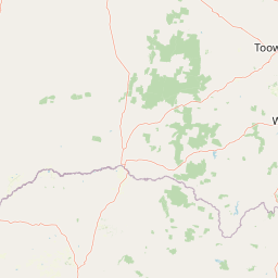
Map view of Alton National Park

Use this park location map to pinpoint Alton National Park in Australia, understand its exact geographic position, and read its mapped placement within the surrounding landscape more clearly.

Pigeon | © OpenStreetMap contributors

Location context for Alton National Park

Queensland
Park atlas

Compare surrounding conservation landscapes and mapped park geography across South West Queensland, Australia.

Explore National Parks and Protected Areas Near Alton National Park, Queensland
Continue your exploration of Australia's protected areas by browsing other national parks and conservation reserves near Alton National Park in South West Queensland. Compare diverse protected landscapes and understand the regional spread of conservation efforts, revealing how unique ecological islands persist within broader geographic contexts.
National parkQueensland

Southwood National Park: Queensland Protected Area and National Park Atlas Entry

Mapped protected landscape and regional geographic context for Southwood National Park.

Southwood National Park serves as a vital component of Queensland's protected lands network, offering a focused view for atlas exploration. Users can examine its specific mapped boundaries and understand its role within the broader geographic context of northeastern Australia. This detailed entry supports structured discovery of the park's natural landscape and its significance as a national park.

Area
71.2 km²
Established
1970
Relief
Lowland
Climate
Arid
National parkQueensland

Erringibba National Park National Park: A Protected Landscape in Queensland's Atlas

Mapped boundaries and regional geographic context for this protected area.

Erringibba National Park, designated as a national park in Queensland, Australia, offers specific insights into protected landscapes and their geographic significance. This entry focuses on understanding the park's mapped features and its contribution to the regional atlas. Users can explore its identity as a protected area, providing a foundation for comprehending its natural landscape within the broader context of Queensland's diverse geography. This is essential for anyone seeking detailed geographic context on Australia's protected natural areas.

Area
8.77 km²
Established
1999
IUCN
II
Relief
Lowland
National parkGoondiwindi Region

Bendidee National Park: Protected Landscape and Geographic Context

National park within the Goondiwindi Region, Australia

Bendidee National Park serves as a key protected area in the Goondiwindi Region of Australia. This detail page provides an atlas-focused perspective, detailing the park's mapped geographic extent and its significance as a natural landscape. Gain structured insights into Bendidee National Park's protected status and its place within the broader regional geography for informed exploration.

Area
9.3 km²
Established
1979
IUCN
II
Relief
Lowland
National parkQueensland

Thrushton National Park: Queensland's Mulga Lands National Park and Protected Landscape

Explore the semi-arid terrain and mapped conservation boundaries.

Thrushton National Park represents a crucial protected landscape within Queensland's Mulga Lands, preserving vast expanses of dense mulga scrub, spinifex sandplains, and dry woodlands. As a National Park, it offers a unique window into the semi-arid ecology of inland Australia, characterized by its subtly undulating terrain and sandy soils. This atlas-focused exploration highlights the park's distinctive vegetation communities and its regional geographic significance, providing a factual base for understanding this vital conservation area.

Area
256.52 km²
Established
1990
IUCN
II
Scope
Terrestrial
National parkQueensland

Wondul Range National Park: Queensland Protected Area and Landscape Mapping

Discover the geographic context and mapped boundaries.

Wondul Range National Park offers a unique protected landscape within Queensland, Australia, serving as a key point for geographic and atlas-based exploration. Delve into its specific regional context, understand its mapped park boundaries, and appreciate its role as a designated national park. This entry provides detailed insights into its natural geography and protected-area significance for comprehensive landscape discovery.

Area
35.55 km²
Established
1992
IUCN
II
Scope
Terrestrial
Watercolor painting of a river flowing between rocky cliffs with forest in the background
National parkNew South Wales

Kwiambal National Park: New South Wales National Park with Granite Landscapes and River Confluence

Explore the dramatic scenery of MacIntyre Falls and surrounding protected terrain.

Kwiambal National Park is a significant protected area in New South Wales, Australia, celebrated for its unique granite outcrops and the spectacular confluence of the Severn and Macintyre Rivers at MacIntyre Falls. This national park provides a clear example of regional protected landscape identity, offering valuable context for atlas-driven discovery of Australia's natural geography and mapped terrain. The park's distinctive features contribute to its importance as a conservation reserve within the New England region.

Area
65.17 km²
Established
2000
IUCN
II
Scope
Terrestrial
National parkSouthern Downs Region

Sundown National Park: National Park with Mapped Protected Boundaries

Southern Downs Region's Protected Landscape Geography

Investigate Sundown National Park, a designated national park in Australia's Southern Downs Region. This resource details its protected landscape identity and geographic setting, offering precise information on its mapped boundaries and regional context for atlas exploration and understanding its conservation value.

Area
160 km²
Established
1977
IUCN
II
Relief
Mountain
National parkAustralia

Culgoa National Park: Iconic Coolabah Woodlands and River Floodplain Landscapes of Australia

Explore mapped boundaries and regional geography in this New South Wales protected area.

Culgoa National Park is a premier example of a preserved semi-arid outback landscape in Australia, celebrated for its extensive and intact coolabah woodlands. This national park protects vital river floodplains and a chain of permanent waterholes along the Culgoa River, contributing significantly to the biodiversity of the Darling River catchment. Understanding its geographic setting and the mapped distribution of its unique vegetation communities offers deep insight into Australia's natural heritage.

Area
352.39 km²
Established
1996
IUCN
II
Relief
Lowland

Common questions about visiting, size, designation, and location context for Alton National Park

Alton National Park FAQs for park facts, access, geography, and protected area context
Find quick answers about Alton National Park, including protected-area facts, park geography, trail and visitor context, and how the park fits into its surrounding country and regional landscape.
MoriAtlas Explorer

Continue Your Protected Areas Search Across the Global Atlas

Deepen your exploration by continuing the structured search for national parks and protected areas worldwide. Utilize the comprehensive filtering capabilities to compare different conservation landscapes and refine your understanding of global park geography. Discover more about the distribution and characteristics of protected natural areas.

Global natural geography