


Mori Atlas logo
Protected areaAlvarado Lagoon System

Mapping the extensive mangrove forests, tidal estuaries, and diverse coastal ecosystems of the Gulf of Mexico

Alvarado Lagoon System: A Comprehensive Geographic Overview of the Veracruz Coastal Wetland Complex

(Sistema Lagunar Alvarado)

The Alvarado Lagoon System represents one of the most significant estuarine complexes on the Mexican Gulf Coastal Plain within the state of Veracruz. This protected area encompasses a complex mosaic of tidal channels, freshwater marshes, and palm woodlands where the Papaloapan River meets the sea. Through this atlas entry, discover the physical geography, mapped wetland boundaries, and the interconnected riverine systems that define this critical biological corridor.

wetlandsestuarylagoon systemmangrovecoastal plainGulf of Mexico
A minimalist flat illustration of a mountain valley with pine trees, a winding river, and a waterfall.

Alvarado Lagoon System

Protected area

Park overview

Structured park overview, official facts, and landscape profile for Alvarado Lagoon System

Alvarado Lagoon System park facts, protected area profile, and essential visitor context

Review the core facts for Alvarado Lagoon System, including designation, size, terrain, visitor scale, habitats, and operating context in one park-focused overview.

About Alvarado Lagoon System

The Alvarado Lagoon System is a vast and ecologically rich coastal wetland complex in the Mexican state of Veracruz, occupying the southern reaches of the Gulf Coastal Plain where the Papaloapan Basin meets the Gulf of Mexico. While the central feature is the brackish Alvarado Lagoon itself, the broader system extends well beyond this single estuary into a network of more than one hundred interconnected bodies of water, including the Camaronera, Tlalixcoyan, Buen País, Popuyeca, and Atzizintla lagoons, and a vast web of tidal channels.

At the heart of the system lies the Papaloapan River, one of the largest and most voluminous rivers in Mexico. The Papaloapan, together with the Blanco, Acula, Limón, and Camarón rivers, delivers enormous freshwater inputs to the estuarine complex, particularly during the rainy season and the winter months when cold northerly winds, locally called 'nortes', drive additional runoff and mixing. The Alvarado Lagoon discharges through the short Papaloapan outlet into the Gulf of Mexico, while a secondary connection is maintained via an artificial channel between the Camaronera Lagoon and the open sea.

The ecological character of the region is shaped by this constant interaction of fresh, brackish, and marine water. The lagoons are bordered by extensive mangrove forests dominated by Rhizophora mangle, with Avicennia germinans and Laguncularia racemosa as common associates. Surrounding the mangrove fringe are coastal dune plant communities, sedge marshes (espadinal) of Cyperus, cattail marshes (tular) of Typha, swamp forests locally called apompales dominated by Pachira aquatica, palm stands that include Sabal mexicana and other native palms, and relict riparian oak forests dominated by Quercus oleoides. Together, these communities represent a remarkably complete cross-section of coastal plain vegetation.

Biologically, the wetland complex stands out as one of the most species-rich lowland sites in eastern Mexico. Roughly 346 species of birds have been recorded, representing a substantial share of Mexico's avifauna. The area supports large resident populations, wintering waterfowl, migratory shorebirds, breeding raptors, and ecologically important assemblages of herons, ducks, pelicans, terns, kingfishers, and flycatchers. The lagoon also provides habitat for vulnerable vertebrate species, including the West Indian manatee, Morelet's crocodile, river turtles, the water opossum, and various small Neotropical felids.

In addition to its Ramsar recognition, the system is referenced in Mexico's broader biodiversity planning as a Terrestrial Priority Region, Marine Priority Region, Hydrological Priority Region, and Important Bird Area. As such, it functions as a flagship example of the ecological value of the Gulf Coastal Plain's estuarine and wetland landscapes.

Quick facts and research context for Alvarado Lagoon System

The Alvarado Lagoon System lies in the south-central portion of the state of Veracruz, in eastern Mexico, between roughly 18°44' N and 18°52' N latitude, near the opening of the Papaloapan River basin into the Gulf of Mexico. While the individual Alvarado Lagoon stretches about 16 kilometers in length and reaches between 3 and 4.5 kilometers in maximum width, the broader wetland complex covers a much larger area of around 267,010 hectares.

The system spans multiple municipalities, including Alvarado, Tlacotalpan, Acula, Ignacio de la Llave, Tlalixcoyan, Lerdo de Tejada, Ixmatlahuacan, Tierra Blanca, Cosamaloapan, Amatitlán, and Carlos A. Carrillo. It operates within a warm subhumid climate, with mean annual temperatures around 26°C, a short dry season from January through May, summer rains from June to October, and the influence of winter northerly winds between November and February.

Although not designated as a formal federal Natural Protected Area under Mexico's SINANP, the complex is recognized under multiple conservation frameworks, including Ramsar status, Important Bird Area designation, and priority region classifications by CONABIO.

Protection and recognition

Documented protection history and official Ramsar wetland designation records

Alvarado Lagoon System Protection Status and International Recognition

Alvarado Lagoon System holds a mixed protection status supported by formal designation records established in 2004. Official documentation details international recognition sources, including the registered Sistema Lagunar Alvarado Ramsar wetland entry.

International recognition

Protection details

Protection scope
Mixed
Designated year
2004
Transboundary protection
No
Park context

Deeper park guide and search-rich context for Alvarado Lagoon System

Alvarado Lagoon System history, landscape, wildlife, and travel context

Explore Alvarado Lagoon System through its history, landscape character, ecosystems, wildlife, conservation priorities, cultural context, and seasonal travel timing in a structured park guide built for atlas discovery and search intent.

Why Alvarado Lagoon System stands out

The Alvarado Lagoon System is most renowned for its enormous estuarine and wetland biodiversity, particularly its exceptional avian richness. More than 340 bird species have been recorded in and around the complex, representing nearly a third of all bird species known in Mexico and including large concentrations of waterbirds, shorebirds, raptors, and migratory passerines. The system is also notable for the size and ecological completeness of its mangrove forests, its extensive tidal channel network, and its position as a brackish water corridor between the Papaloapan watershed and the Gulf of Mexico. Together with its associated palm swamp forests, sedge marshes, and dune vegetation, the wetland complex provides a full suite of coastal plain habitats in a single region. An additional identity marker is the presence of conspicuous, wide-ranging species such as the West Indian manatee, Morelet's crocodile, Jabiru stork, and a broad representation of Neotropical raptors, which collectively underscore the area's value as a regional stronghold for coastal wildlife.
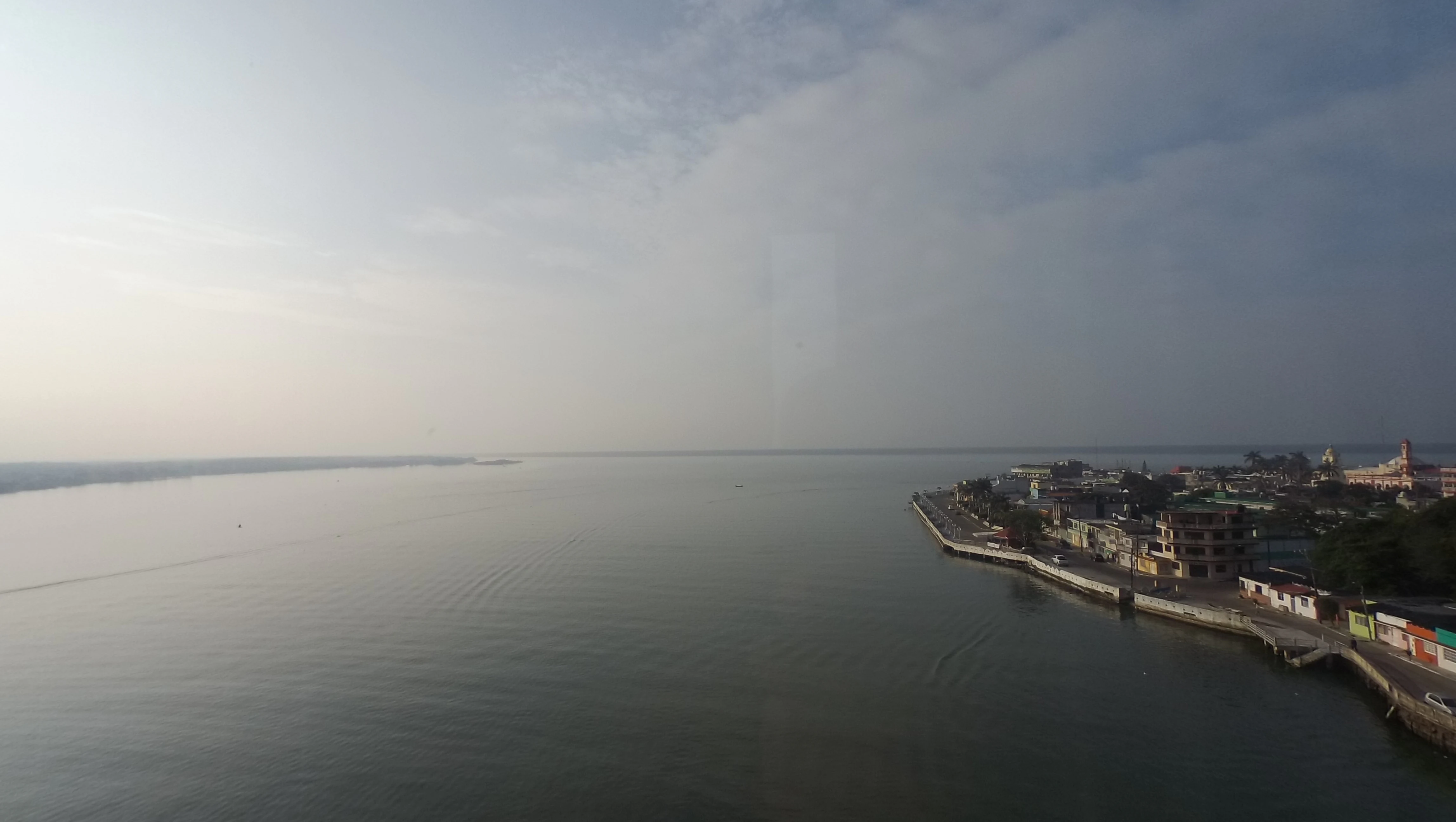
An elevated wide shot looking out over a calm, expansive body of water bordering the town of Alvarado, featuring a coastal promenade and urban buildings along the shoreline.
View of the Alvarado port area along the lagoon system in Veracruz, Mexico.

Alvarado Lagoon System history and protected-area timeline

The lagoon and its surrounding landscape have been shaped over time by the powerful discharge of the Papaloapan and adjacent river systems, which together form one of the largest rivers draining the eastern flank of Mexico's central highlands into the Gulf of Mexico. Recorded European contact with the area dates to 1518, when Pedro de Alvarado led an expedition along this stretch of the Gulf coast, after whom the lagoon is named. The town and port of Alvarado later became a permanent feature on this stretch of coastline and remains closely associated with the wetland complex.

In the modern era, the recognition of the system's ecological importance grew through scientific studies conducted by institutions such as UNAM, the Universidad Veracruzana, INECOL, and CONABIO, which together documented its high biodiversity and its vulnerability to surrounding land uses. This body of research culminated in February 2004, when the Alvarado Lagoon System was formally designated as a Ramsar Wetland of International Importance, providing it with international recognition and helping frame ongoing debates about its management and protection.

Alvarado Lagoon System landscape and geographic character

The physical setting of the Alvarado Lagoon System is characteristic of the southern Gulf Coastal Plain, locally identified as the Llanura de Sotavento. The terrain is low-lying and largely flat, dominated by a broad wedge of alluvial and coastal sediments delivered by the Papaloapan and its tributaries. The central Laguna de Alvarado stretches roughly 16 kilometers in length and reaches between 3 and 4.5 kilometers at its widest points, but it is only one element in a much larger mosaic.

Beyond the main lagoon body, the wider system includes more than a hundred smaller interior lagoons, tidal channels, and coastal lagoons that vary in salinity from fresh to fully marine. Coastal dunes line portions of the seaward margin, while the inland edge of the system transitions smoothly into freshwater marshes, palm forests, swamp forests, and riparian oak woodlands. The seasonal rhythm of the landscape is strongly influenced by three climatic phases: a brief dry period from January to May, a wet summer from June to October, and the nortes period from late autumn through midwinter, when cold continental air masses sweep across the Gulf coast.

Alvarado Lagoon System ecosystems, habitats, and plant life

Ecologically, the Alvarado Lagoon System is a transitional environment where freshwater inflows from the Papaloapan basin meet the brackish waters of the Gulf coastal lagoon system and the open sea. The result is a dynamic mosaic of habitats that includes mangrove forest, coastal dune vegetation, sedge marsh, cattail marsh, swamp forest, palm forest, riparian oak woodland, secondary deciduous forest, seasonally flooded grasslands, and aquatic plant communities such as extensive stands of water hyacinth and submerged Ruppia maritima meadows near the mangrove fringe.

This habitat variety supports exceptionally high biological diversity. The bird community alone includes more than 340 recorded species drawn from a wide range of ecological groups, including herons, ducks, shorebirds, gulls and terns, kingfishers, flycatchers, warblers, and icterids. The mangrove and submerged aquatic habitats also support more than 100 fish species, 62 mollusk species, and 32 crustacean species, alongside diverse insects and other invertebrates. The combination of mangrove, swamp forest, palm forest, and riparian oak associates gives the region a layered tropical and subtropical character unusual among Mexican coastal wetland systems.

Alvarado Lagoon System wildlife and species highlights

The Alvarado Lagoon System is particularly notable for its avifauna, with 346 bird species recorded in the wetlands and adjacent habitats. Roughly 50 percent of these species are year-round residents, 32 percent winter residents, 2 percent summer residents, and the remainder occasional or transitory. The wetlands serve as a major congregation area for waterbirds, with notable populations of northern pintail, American white pelican, brown pelican, piping plover, least bittern, and white-winged dove.

The complex is also an important breeding area for raptors, including snail kite, common black hawk, great black hawk, and black-collared hawk. Migration brings additional species such as scissor-tailed flycatcher and eastern kingbird. Several at-risk species are present, including snail kite, piping plover, least bittern, peregrine falcon, and lesser yellow-headed vulture.

Beyond birds, the lagoons and surrounding habitats are home to remarkable mammals such as the West Indian manatee, the water opossum, and the tamandua, while reptiles include Morelet's crocodile and distinctive freshwater turtles such as the Central American river turtle and the narrow-bridged musk turtle. This combination of migratory, resident, and highly localized species gives the wildlife profile of the lagoon system a distinctive Neotropical coastal character.

Alvarado Lagoon System conservation status and protection priorities

The Alvarado Lagoon System is one of the most important wetland conservation sites along Mexico's Gulf Coast, recognized under multiple national and international frameworks. In 2004, it was designated as a Ramsar Wetland of International Importance, covering 267,010 hectares. It is also classified as an Important Bird Area and has been included by CONABIO as a Terrestrial Priority Region, a Marine Priority Region, and a Hydrological Priority Region, reflecting its combined terrestrial, marine, and freshwater value.

Outside of federal Natural Protected Area status under SINANP, the system is nevertheless widely treated as a conservation priority due to its role in supporting regional biodiversity, migratory bird populations, mangrove ecosystems, and vulnerable coastal species such as the West Indian manatee. Conservation research in the area has been led by institutions such as UNAM, the Universidad Veracruzana, INECOL, and CONABIO, helping build a strong scientific baseline for the area.

Alvarado Lagoon System cultural meaning and human context

The environmental and cultural identity of the region around the Alvarado Lagoon System is closely tied to the legacy of Pedro de Alvarado, the Spanish explorer whose 1518 expedition gave the lagoon, the nearby town, and the surrounding municipality their name. The mouth of the Papaloapan River, which flows through the system, has long supported local settlement, fishing communities, and river trade, with the town of Alvarado itself serving as a port at the lagoon's edge.

The broader wetland landscape is shared across numerous Veracruz municipalities, including Alvarado, Tlacotalpan, Acula, Ignacio de la Llave, Tlalixcoyan, Lerdo de Tejada, Ixmatlahuacan, Tierra Blanca, Cosamaloapan, Amatitlán, and Carlos A. Carrillo, each of which maintains long-standing relationships with the lagoons, the surrounding agriculture (including sugarcane), and traditional fishing practices.

Top sights and standout views in Alvarado Lagoon System

Among the most distinctive features of the Alvarado Lagoon System are its exceptional bird richness, with 346 species representing nearly a third of all Mexican bird species; the expansive mangrove forests dominated by red mangrove; the seasonal freshwater pulse delivered by the Papaloapan River; and the rare coexistence of coastal dune, swamp forest, palm forest, and riparian oak woodland habitats within a single integrated system.

The wetland's broad coverage across more than 267,000 hectares, its identification with a major historical explorer in Pedro de Alvarado, and its simultaneous recognition under Ramsar, AICA, and multiple CONABIO frameworks make it a flagship reference site for the conservation of Mexico's Gulf coastal wetlands.

Best time to visit Alvarado Lagoon System

The character of the Alvarado Lagoon System changes significantly across its three main seasonal phases. The rainy season from June to October brings higher freshwater flows from the Papaloapan and tributary rivers, expanding wetland extent, supporting abundant aquatic vegetation, and concentrating waterbirds, fish, and aquatic invertebrates across the lagoons. November to February brings the nortes, with cold frontal winds that stir up mixing between marine and freshwater bodies and influence bird migration and seasonal visibility of coastal wildlife. The drier period from January to May, while shorter, offers clearer atmospheric conditions for observing the lagoon's structural features, mangrove fringes, and shoreline vegetation.

For an ecologically oriented visit, the late rainy and nortes seasons are particularly rewarding because freshwater inflows, waterbird congregations, and seasonal manatee activity are at or near their peaks. For a calmer experience with clearer water conditions, the drier period offers a useful contrast.
Monthly climate preview

Long-term temperature and precipitation records measured across representative coordinates

Alvarado Lagoon System Climate Normals and Annual Weather by Month

Historical data compiled from NASA Power reveals distinct annual temperature and precipitation shifts across measured representative coordinates in Veracruz. Reviewing the complete monthly climate profile provides deeper context on long-term weather patterns and seasonal averages for Alvarado Lagoon System.
Annual mean25 °C
21 °C29 °C
Jan21°
Feb22°
Mar24°
Apr28°
May29°
Jun28°
Jul27°
Aug27°
Sep27°
Oct25°
Nov23°
Dec22°
Warmest month
May

29.1 °C

Coolest month
January

21 °C

Wettest month
September

12.8 mm/day

Driest month
March

0.9 mm/day

Park location guide

Geography guide, regional context, and park location map for Alvarado Lagoon System

Alvarado Lagoon System park geography, regions, and map view in Mexico

Understand where Alvarado Lagoon System sits in Mexico through a broader geographic reading of the surrounding landscape, nearby location context, and its mapped position within the national park landscape.

How Alvarado Lagoon System fits into Mexico

Mexico, officially the United Mexican States, is a country in North America spanning the Sierra Madre mountain ranges, coastal plains, and tropical regions. It borders the United States to the north, Guatemala and Belize to the southeast, and has coastlines along the Pacific Ocean, Gulf of Mexico, and Caribbean Sea. With a population exceeding 130 million, Mexico is home to one of the world's most significant concentrations of Indigenous languages alongside Spanish.

Wider geography shaping Alvarado Lagoon System in Mexico

Mexico occupies a land area of 1,972,550 km2, making it the thirteenth-largest country in the world. The terrain is highly diverse, featuring the Sierra Madre Occidental and Sierra Madre Oriental mountain ranges, the Mexican Plateau, coastal lowlands along the Pacific and Gulf/Caribbean margins, and the Yucatan Peninsula. The country spans multiple climate zones from desert in the north to tropical rainforest in the south.

Map view of Alvarado Lagoon System

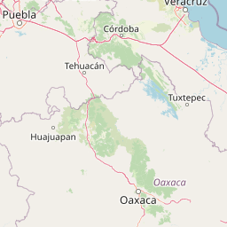
Use this park location map to pinpoint Alvarado Lagoon System in Mexico, understand its exact geographic position, and read its mapped placement within the surrounding landscape more clearly.

Pigeon | © OpenStreetMap contributors

Location context for Alvarado Lagoon System

Veracruz

Visual exploration of coastal wetlands, tidal channels, and mangrove forests

Alvarado Lagoon System Photos and Landscape Scenery

Visual documentation captures the complex mosaic of mangrove forests, interior lagoons, and tidal channels defining the protected coastal plain. Examining landscape photography helps researchers understand the diverse wetland habitats and estuarine environments shaping the region.

An elevated wide shot looking out over a calm, expansive body of water bordering the town of Alvarado, featuring a coastal promenade and urban buildings along the shoreline.

Park atlas

Discover related coastal wetlands, estuaries, and protected landscapes across the surrounding region

Parks Near Alvarado Lagoon System and Regional Protected Areas to Compare

Browsing other parks near Alvarado Lagoon System reveals connected coastal wetland complexes and estuarine habitats throughout the Gulf coastal plain. Comparing these regional protected areas highlights shared ecological patterns and diverse wetland geomorphology across the broader coastal watershed.
National parkMexico
About 59 km away#1 closest

North

Sistema Arrecifal Veracruzano National Marine Park: Mexico's Coastal National Park

Explore mapped boundaries and regional protected landscape.

Delve into the protected landscape of Sistema Arrecifal Veracruzano National Marine Park, a vital national park situated off the coast of Mexico. This page provides detailed insights into its mapped boundaries and geographic context, crucial for understanding the distribution of protected marine areas within the region. It serves as a gateway to appreciating the park's specific contribution to Mexico's conservation efforts and its place in broader geographic atlases.

IUCN
VI
Scope
Marine
Water
Water-dominated
National parkVeracruz
About 140 km away#2 closest

West

Cañón del Río Blanco National Park: Explore Its Mapped Protected Area and Regional Geography

Discover the geographic context and protected landscape of this national park.

Cañón del Río Blanco National Park offers a distinct protected-area identity within the geography of Veracruz. This canonical page focuses on the park's mapped boundaries and its significance as a national park. Use this resource for structured exploration of its protected landscape and regional setting, enhancing your understanding of Mexican protected areas.

Area
488 km²
Established
1938
IUCN
II
Relief
Mountain
Protected areaVeracruz
About 146 km away#3 closest

Northwest

Cascada de Texolo Protected Landscape: Geographic Profile and Waterfall Map Context

Veracruz highlands forest and ravine ecosystem.

Cascada de Texolo represents a protected forest and stream corridor in the Veracruz highlands of Mexico. Recognized as a Ramsar wetland, the site features a dramatic waterfall dropping into a dense ravine, surrounded by humid montane forest. This map-focused profile examines the landscape structure, stream networks, and the integration of the gorge into the regional geography of Xico and Xalapa.

Established
2006
Relief
Upland
Access
Access unknown
Scope
Terrestrial
National parkMexico
About 155 km away#4 closest

West

Pico de Orizaba National Park: Mexico's Key National Park for Atlas Exploration

Discover mapped boundaries and regional geographic context.

Access detailed atlas information for Pico de Orizaba National Park, a protected natural area in Mexico. This entry focuses on its geographic scope, mapped landscape features, and its significance as a national park within the region. Explore the park's protected boundaries and understand its place in the broader geographical context of Mexico.

IUCN
II
National parkMexico
About 166 km away#5 closest

Northwest

Cofre de Perote National Park: A National Park within Mexico's Geographic Atlas

Explore its protected landscape and regional map context.

Cofre de Perote National Park is a vital protected area within Mexico, offering a unique national park designation. This entry focuses on its geographic significance, mapping its boundaries and situating it within the country's broader protected lands. Users can explore the park's landscape identity and its atlas-relevant features, providing a factual basis for understanding its role in Mexico's natural heritage.

Established
1937
IUCN
II
Relief
Mountain
Climate
Alpine
National parkOaxaca
About 189 km away#6 closest

Southwest

Benito Juárez National Park: A Protected Landscape within Oaxaca's Regional Geography

Discover its mapped boundaries and national park atlas context

Benito Juárez National Park offers a vital focal point for understanding protected landscapes and regional geography in Oaxaca. This entry details the park's designated protected area status and its position within Mexico's mapped natural terrain. Explore the geographic context and atlas value of this national park, providing a foundation for structured discovery of its natural features and boundaries.

Area
27.37 km²
Established
1937
IUCN
II
Relief
Mountain
Natural monumentOaxaca
About 198 km away#7 closest

South

Yagul Natural Monument: Geographic Profile and Protected Landscape Context in Oaxaca

Mapped terrain, cultural landscape, and Zapotec valley geography.

Yagul represents a critical intersection of archaeological heritage and semi-arid valley geography. By examining the site's artificial platforms, defensive hilltop positioning, and the surrounding network of rock shelters, one gains insight into the environmental factors that shaped this central hub of the Zapotec world. The protected area provides a defined boundary for investigating how ancient human activity successfully integrated with the complex, drought-prone terrain of the Oaxacan highlands.

Relief
Upland
Climate
Arid
Scope
Terrestrial
Water
Minor water
National parkTlaxcala
About 239 km away#8 closest

West

La Malinche National Park: Protected Landscape and Regional Geography in Tlaxcala

Explore mapped boundaries and natural terrain.

La Malinche National Park is a vital protected landscape offering rich insights into regional geography and natural terrain. This canonical entry provides focused details on the park's protected area identity, its mapped geographic scope within Tlaxcala, and its place in the broader atlas of Mexican conservation lands. Understand the specific landscape characteristics and geographic context that define this significant national park.

Established
1938
IUCN
II
Relief
Mountain
Access
Moderate access

Common questions about visiting, size, designation, and location context for Alvarado Lagoon System

Alvarado Lagoon System FAQs for park facts, access, geography, and protected area context

Find quick answers about Alvarado Lagoon System, including protected-area facts, park geography, trail and visitor context, and how the park fits into its surrounding country and regional landscape.
MoriAtlas Explorer

Continue Your Protected Areas Search Across the Global Atlas

Deepen your exploration by continuing the structured search for national parks and protected areas worldwide. Utilize the comprehensive filtering capabilities to compare different conservation landscapes and refine your understanding of global park geography. Discover more about the distribution and characteristics of protected natural areas.

Global natural geography