Mori Atlas logo
National parkAndasibe-Mantadia National Park

Discover the mapped boundaries and geographic setting of this vital national park.

Andasibe-Mantadia National Park: Protected Landscape and Regional Geography in Alaotra-Mangoro

Andasibe-Mantadia National Park stands as a key protected area within Madagascar's Alaotra-Mangoro region, offering a focused lens for understanding regional geography and landscape preservation. This entry details the park's specific geographic scope and its role as a mapped protected territory, providing essential context for atlas-based exploration of eastern Madagascar's natural environments. Delve into the mapped boundaries and the unique environmental character that defines this significant national park.

RainforestLemursEastern MadagascarUNESCO Biosphere ReservePrimary ForestWildlife Viewing

Andasibe-Mantadia National Park

National park

Park overview

Structured park overview, official facts, and landscape profile for Andasibe-Mantadia National Park

Andasibe-Mantadia National Park park facts, protected area profile, and essential visitor context
Review the core facts for Andasibe-Mantadia National Park, including designation, size, terrain, visitor scale, habitats, and operating context in one park-focused overview.

About Andasibe-Mantadia National Park

Andasibe-Mantadia National Park represents one of Madagascar's most accessible and ecologically significant rainforest protected areas. Located in the Alaotra-Mangoro Region of eastern Madagascar, the park sits approximately 150 kilometers east of Antananarivo along Route Nationale 2, making it achievable for visitors without extensive travel logistics. The park encompasses 155 square kilometers of primary forest growth, a rare and precious resource in Madagascar where deforestation has dramatically reduced the island's original forest cover. The park's elevation gradient from 800 to 1260 meters creates diverse microhabitats within the rainforest, supporting the extraordinary species richness that makes this area globally significant. The humid climate, characterized by heavy seasonal rainfall, sustains the lush vegetation that defines this ecosystem and provides the moisture necessary for the diverse flora and fauna to thrive. Beyond its biological importance, the park serves as a critical watershed for local communities, regulating water flow and protecting soils in a region where agricultural pressure is intense. Visitors to the park can explore trails ranging from one to six hours in length, with guided walks through both the Analamazoatra section near the main road and the more remote Mantadia section that requires special transportation arrangements. The park's popularity stems not only from its wildlife viewing opportunities but also from the relatively straightforward logistics of visiting, as it is one of the easiest parks in Madagascar to access from the capital city.

Quick facts and research context for Andasibe-Mantadia National Park

Andasibe-Mantadia National Park spans 155 square kilometers of primary rainforest in eastern Madagascar, located in the Alaotra-Mangoro Region about a three-hour drive from Antananarivo via Route Nationale 2. The park protects 11 lemur species, including the indri, Madagascar's largest lemur, as well as the diademed sifaka and black-and-white ruffed lemur. Elevation ranges from 800 to 1260 meters with annual rainfall of 1700 millimeters. The park consists of two sections: Mantadia National Park and Analamazoatra Reserve. It was designated a UNESCO biosphere reserve in 2025 and receives around 26,000 visitors per year.

Park context

Deeper park guide and search-rich context for Andasibe-Mantadia National Park

Andasibe-Mantadia National Park history, landscape, wildlife, and travel context
Explore Andasibe-Mantadia National Park through its history, landscape character, ecosystems, wildlife, conservation priorities, cultural context, and seasonal travel timing in a structured park guide built for atlas discovery and search intent.

Why Andasibe-Mantadia National Park stands out

Andasibe-Mantadia is best known for its remarkable lemur populations, particularly the indri, which is the largest lemur species in Madagascar and perhaps the most iconic resident of the park. The Analamazoatra section is particularly celebrated for reliable indri sightings, as these animals have become habituated to human presence. The park also protects ten additional lemur species, including the critically endangered diademed sifaka and the black-and-white ruffed lemur, both of which have been the focus of successful reintroduction programs. The park's accessibility from the capital, combined with its dense rainforest trails and the distinctive calls of indri that echo through the canopy, makes it one of Madagascar's most visited and beloved protected areas.

Andasibe-Mantadia National Park history and protected-area timeline

The conservation history of Andasibe-Mantadia reflects the broader story of Madagascar's struggle to preserve its unique biodiversity amid development pressures. The Analamazaotra Special Reserve, also known locally as Andasibe or Périnet, was historically connected to the larger Mantadia National Park, which once included adjacent forest areas such as Maromizaha Classified Forest to the southeast and Anosibe an'ala to the south. However, systematic deforestation for logging, agricultural expansion, and the establishment of commercial tree plantations has fragmented this landscape, leaving the park as an isolated island of forest surrounded by transformed land. The primary threats to the park stem from habitat loss in the surrounding area, where native rainforest has been replaced by Australian eucalyptus and Chinese pine plantations, and where slash-and-burn cultivation for rice agriculture continues to expand. These pressures are exacerbated by Madagascar's extremely high population growth rate and widespread rural poverty, which drive communities to convert forest land for subsistence agriculture. The national park was officially established in 1989 under the management of Madagascar National Parks Association, formalizing protection for this critical rainforest habitat. In 2007, the park was nominated for inclusion in the World Heritage Site of Rainforests of the Atsinanana, though the park's forests were ultimately not selected for the final list. A significant milestone came in 2025 when the park was designated as a UNESCO biosphere reserve, acknowledging its global importance and strengthening its conservation framework.

Andasibe-Mantadia National Park landscape and geographic character

The physical landscape of Andasibe-Mantadia is characterized by rolling terrain within the eastern Madagascar highlands, where elevation rises from 800 meters at the lower boundaries to approximately 1260 meters at the highest points. The terrain is dominated by dense, humid rainforest with a complex vertical structure featuring emergent trees, a dense canopy, understory vegetation, and forest floor layers. The landscape receives heavy rainfall, with approximately 1700 millimeters falling annually across roughly 210 rainy days, creating consistently humid conditions that sustain the forest's lush vegetation. Streams and small rivers traverse the park, fed by the high precipitation, and the park likely contains areas of wetland or marshy terrain typical of Malagasy rainforest. The forest surrounding the trails is visually dramatic, with towering trees, dense epiphytes, and the constant sound of dripping water and bird calls. While the park itself remains forested, the surrounding landscape tells a different story, with visible boundaries where native forest gives way to plantations of eucalyptus and pine, illustrating both the value of what is protected within the park and the pressures that threaten the broader ecosystem.

Andasibe-Mantadia National Park ecosystems, habitats, and plant life

The ecological character of Andasibe-Mantadia is defined by its status as a humid rainforest ecosystem within the Alaotra-Mangoro Region of Madagascar. This primary forest represents a critical repository of biodiversity, hosting species found nowhere else on Earth due to Madagascar's long-term isolation as an island. The park's elevation gradient creates multiple habitat zones, from lower elevation forest to higher altitude areas with different species assemblages and vegetation patterns. The humidity and consistent rainfall support epiphytic plants including orchids, ferns, and mosses that carpet tree trunks and branches, creating the classic appearance of a tropical rainforest. The forest structure provides habitat layers that support diverse ecological niches, from canopy-dwelling lemurs and birds to ground-dwelling mammals and invertebrates. This ecosystem is part of the larger Rainforests of the Atsinanana, a recognized center of plant endemism that extends along the eastern spine of Madagascar. The park's biodiversity value is concentrated in its lemur populations, but the forest also supports numerous bird species, reptiles, amphibians, and insects that together form a complex ecological community.

Andasibe-Mantadia National Park wildlife and species highlights

The wildlife of Andasibe-Mantadia is exceptionallyrich, with lemurs serving as the flagship attraction and defining the park's ecological identity. The park protects 11 lemur species, a remarkable concentration that reflects the park's diverse habitats and its position within Madagascar's eastern rainforest belt. The indri, the largest of all lemurs and perhaps Madagascar's most iconic animal, is the star attraction, particularly in the Analamazoatra section where habituated groups can be reliably encountered. The diademed sifaka, with its striking black and white coloration and distinctive large eyes, was the focus of a significant reintroduction program that successfully established populations in the park after translocating individuals from threatened habitat areas. The black-and-white ruffed lemur, another visually striking species, has also benefited from reintroduction efforts. Beyond lemurs, the park supports diverse birdlife, including various endemic species adapted to rainforest habitats. The park's streams and forest floor provide habitat for amphibians and reptiles, while the insect fauna is extraordinarily diverse though less visible to visitors. The wildlife viewing experience is enhanced by the relatively accessible trail system and the presence of guides who can help visitors locate and interpret animal behavior.

Andasibe-Mantadia National Park conservation status and protection priorities

The conservation significance of Andasibe-Mantadia extends beyond its borders as a critical stronghold for Madagascar's endemic biodiversity. The park's designation as a UNESCO biosphere reserve in 2025 acknowledges its global importance and integrates conservation with sustainable development objectives. The park protects primary rainforest in a region where forest loss has been severe, making this habitat island critically important for species survival. The 11 lemur species protected here include numerous species classified as endangered or critically endangered, and the park's populations serve as important insurance against extinction in the face of broader habitat loss. Conservation challenges remain significant, however, as the primary threat to the park comes from habitat disappearance outside the protected boundaries. The replacement of native forest with eucalyptus and pine plantations, combined with slash-and-burn agriculture, continues to shrink the available habitat for species that require large territories and forest connectivity. The reintroduction program for diademed sifaka and black-and-white ruffed lemur represents an active conservation intervention that has demonstrated success in establishing viable populations within the park, providing a model for similar efforts elsewhere in Madagascar.

Andasibe-Mantadia National Park cultural meaning and human context

The cultural context of Andasibe-Mantadia is closely tied to the local communities who live in the vicinity of the park and who have traditional connections to the forest landscape. The Analamazoatra Reserve is known locally simply as Andasibe, taking its name from the nearby village, and this local identity reflects the long-standing relationship between people and this forest area. The park lies within the Alaotra-Mangoro Region, home to Malagasy communities whose livelihoods are closely tied to the land, though the intense population growth and poverty rates in rural Madagascar create pressure on forest resources. The park management involves collaboration with local communities, and the reintroduction program has specifically incorporated community benefits through education initiatives and employment as guides. Visitors to the park are required to have local guides, a policy that both ensures safety and provides economic benefit to community members. The relationship between the park and surrounding communities represents both a conservation challenge, as local resource needs place pressure on forest boundaries, and an opportunity for integrated conservation that supports human well-being while protecting biodiversity.

Top sights and standout views in Andasibe-Mantadia National Park

Andasibe-Mantadia offers visitors the chance to experience Madagascar's iconic rainforest wildlife in one of the most accessible locations in the country. The park's headline experience is hearing and hopefully observing the indri, whose distinctive wailing calls resonate through the forest and create an unforgettable soundtrack to a rainforest hike. The diademed sifaka, with its dramatic black and white fur and golden eyes, represents another highlight, particularly for those lucky enough to see the reintroduced groups that have established successful breeding populations in the park. The guided trail system through both Analamazoatra and Mantadia sections allows visitors to explore different aspects of the forest, from the more accessible trails near the main road to the more remote areas that require special arrangements. The park's status as a UNESCO biosphere reserve, combined with its 11 lemur species and successful reintroduction program, makes it a model for Malagasy conservation. The relative ease of access from Antananarivo, with a three-hour drive on paved roads, means this remarkable wildlife experience is available to visitors with limited time in the country.

Best time to visit Andasibe-Mantadia National Park

The best time to visit Andasibe-Mantadia depends on what experience visitors are seeking, though the park can be visited year-round given its accessible location and established tourism infrastructure. The dry season, typically from May to October, offers more comfortable hiking conditions with lower humidity and less rain, making trail walking more pleasant and reducing the challenges of wet conditions. However, this period corresponds to the cooler months, and some visitors may find the reduced visibility in the forest due to lower canopy moisture a trade-off. The wet season, from November to April, brings heavier rainfall but also the dramatic atmosphere of a full rainforest, with waterfalls potentially at their most impressive and the forest at its most lush and green. Wildlife viewing may be somewhat more challenging during heavy rain, but lemurs remain active year-round and can be encountered in any season. The park's popularity means that accommodations can fill during peak tourist seasons, so advanced booking is advisable for those planning visits during the most popular periods.
Park location guide

Geography guide, regional context, and park location map for Andasibe-Mantadia National Park

Andasibe-Mantadia National Park park geography, regions, and map view in Madagascar
Understand where Andasibe-Mantadia National Park sits in Madagascar through a broader geographic reading of the surrounding landscape, nearby location context, and its mapped position within the national park landscape.

How Andasibe-Mantadia National Park fits into Madagascar

Madagascar is an island nation in the Indian Ocean, positioned off the southeastern coast of Africa. As the world's fourth-largest island and second-largest island country, it stands out for its exceptional biodiversity, over 90% of its wildlife is endemic, making it one of 17 megadiverse countries. The population is approximately 32 million, with Antananarivo as both the capital and largest city.

Wider geography shaping Andasibe-Mantadia National Park in Madagascar

Madagascar lies in the Indian Ocean off the southeastern coast of Africa, separated from the mainland by the Mozambique Channel. The island is situated approximately 400 km from the African continent. As the world's fourth-largest island, it also includes numerous smaller peripheral islands.

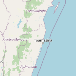
Map view of Andasibe-Mantadia National Park

Use this park location map to pinpoint Andasibe-Mantadia National Park in Madagascar, understand its exact geographic position, and read its mapped placement within the surrounding landscape more clearly.

Pigeon | © OpenStreetMap contributors

Location context for Andasibe-Mantadia National Park

Alaotra-Mangoro
Park atlas

Explore adjacent rainforest landscapes and other key protected areas across the surrounding Malagasy highlands.

Discover Nearby National Parks and Protected Areas Beyond Andasibe-Mantadia National Park
Continue your park discovery by tracing other national parks and protected areas geographically close to Andasibe-Mantadia National Park, focusing on similar rainforest ecosystems and unique Malagasy biodiversity. Broaden your understanding of regional conservation landscapes, comparing diverse protected-area characteristics and exploring the broader eastern Madagascar highlands context.
Watercolor illustration of a landscape featuring mountains, a lake, trees, and pink flowers in the foreground
National parkAlaotra-Mangoro

Analamazaotra National Park: Protected Rainforest Ecosystem and Mapped Landscape in Alaotra-Mangoro

Explore Madagascar's Eastern Highlands protected area geography.

Analamazaotra National Park, situated in Madagascar's Alaotra-Mangoro region, represents a critical segment of the island's protected eastern rainforests. This national park is mapped as a vital conservation area, offering insights into its unique ecosystems and natural terrain. Understanding Analamazaotra National Park's geographic placement and protected boundaries provides essential context for regional landscape exploration and atlas-based geographic discovery within Madagascar.

Area
26.53 km²
Established
2015
IUCN
II
Relief
Highland
National parkMadagascar

Zahamena National Park: Madagascar National Park Exploration and Geographic Context

Mapping the protected boundaries and landscape of Zahamena National Park.

Delve into Zahamena National Park, a vital protected territory situated in Madagascar. This national park offers a unique perspective on the island's natural geography and its status as a significant protected landscape. Understand its position within Madagascar's broader context, focusing on the mapped aspects of its protected area identity and its contribution to the country's renowned biodiversity hotspot status.

Area
423 km²
Established
1997
IUCN
II
Relief
Mountain
National parkMadagascar

Marolambo National Park: Madagascar's National Park and Protected Landscape

Explore mapped boundaries and regional geography.

Marolambo National Park stands as a protected national park within Madagascar's globally recognized biodiversity hotspot. This entry provides focused insight into its protected landscape, its specific geographic context within the island nation, and its role in the conservation of unique natural terrain. Understanding Marolambo National Park through its mapped boundaries and regional geography contributes to a broader atlas exploration of Madagascar's endemic ecosystems.

Area
950.63 km²
Climate
Tropical
Access
Remote access
Scope
Terrestrial
National parkMadagascar

Ranomafana National Park: Madagascar's premier Tropical Rainforest Protected Area

Explore its unique mapped geography and landscape context.

Ranomafana National Park stands as a crucial national park within Madagascar's protected lands, safeguarding a significant expanse of tropical rainforest. This page offers a deep dive into its geographic setting, detailing the mapped boundaries and the distinctive natural terrain that supports its exceptional biodiversity. Discover the atlas value of this protected landscape for understanding regional conservation and geographic context.

Area
416 km²
Established
1991
IUCN
II
Climate
Tropical
National parkBoeny Region

Ankarafantsika National Park: Protected Area Atlas and Regional Geography Discovery

Explore mapped boundaries and natural landscape context.

Ankarafantsika National Park serves as a key protected area for understanding the geography of Madagascar's Boeny Region. This canonical page offers a detailed atlas-style view, highlighting the park's mapped boundaries and its role as a distinct natural landscape. Engage with structured geographic data to comprehend the park's protected status and its contribution to the regional terrain, facilitating a deeper appreciation of protected lands.

Area
1,365.13 km²
Established
2002
IUCN
II
Relief
Lowland
National parkHaute Matsiatra

Andringitra National Park: A Protected Landscape within Haute Matsiatra's Geography

Explore mapped park boundaries and regional terrain.

Andringitra National Park represents a vital protected area within the Haute Matsiatra region, contributing significantly to the mapped landscape of central Madagascar. Its designation as a national park underscores its importance for conservation and geographic study. Users exploring this destination can gain a detailed understanding of its specific protected boundaries, the surrounding natural terrain, and its overall contribution to the regional geography, making it a key site for atlas-based landscape discovery.

Area
311.6 km²
Established
1999
IUCN
II
Visitors
3.4K annual
National parkMelaky

Tsingy de Bemaraha National Park: A Protected Landscape within Melaky, Madagascar

Explore mapped boundaries and regional geography for atlas discovery.

Tsingy de Bemaraha National Park is a designated national park offering profound opportunities for geographic discovery. As a key protected area in the Melaky region, its mapped boundaries and natural landscape characteristics are vital for understanding Madagascar's conservation geography. This resource facilitates detailed atlas exploration, providing structured insights into the park's terrain and its position within the broader regional context, enabling a focused study of its protected land identity.

Area
723.4 km²
Established
1997
IUCN
II
Visitors
10.1K annual
National parkBoeny

Baie de Baly National Park: Mapped Boundaries and Protected Landscape Context

Explore the geography and natural terrain of this national park.

Baie de Baly National Park presents a critical focal point for understanding protected areas within the Boeny region. As a national park, it showcases specific mapped boundaries that contribute to the broader geographic understanding of Madagascar's conservation landscapes. This detailed view allows for an atlas-driven exploration of the park's natural terrain and its significance as a distinct protected landmass within its regional context.

Area
571.42 km²
Established
1997
IUCN
II
Climate
Tropical

Common questions about visiting, size, designation, and location context for Andasibe-Mantadia National Park

Andasibe-Mantadia National Park FAQs for park facts, access, geography, and protected area context
Find quick answers about Andasibe-Mantadia National Park, including protected-area facts, park geography, trail and visitor context, and how the park fits into its surrounding country and regional landscape.
MoriAtlas Explorer

Continue Your Protected Areas Search Across the Global Atlas

Deepen your exploration by continuing the structured search for national parks and protected areas worldwide. Utilize the comprehensive filtering capabilities to compare different conservation landscapes and refine your understanding of global park geography. Discover more about the distribution and characteristics of protected natural areas.

Global natural geography