Mori Atlas logo
National parkÄngsö National Park

Discover the unique mapped environment of this historic Swedish national park

Ängsö National Park: Stockholm County's Flower-Rich Protected Landscape & Archipelago Geography

Ängsö National Park represents a preserved slice of Sweden's early 20th-century cultural landscape within Stockholm County's northern archipelago. This island national park, established in 1909, is celebrated for its exceptionally flower-rich meadows, mature deciduous forests, and its unique character shaped by centuries of agricultural use. MoriAtlas provides a detailed view of its protected boundaries and geographic context, offering a window into one of the archipelago's most distinguished natural and historical sites.

Island parkCultural landscapeFlower meadowsDeciduous forestArchipelagoBird protection
A stylized illustration showing a valley with a waterfall, green meadows, wildflowers, and trees under a partly cloudy sky

Ängsö National Park

National park

Park overview

Structured park overview, official facts, and landscape profile for Ängsö National Park

Ängsö National Park park facts, protected area profile, and essential visitor context
Review the core facts for Ängsö National Park, including designation, size, terrain, visitor scale, habitats, and operating context in one park-focused overview.

About Ängsö National Park

Ängsö National Park is a distinctive island protected area in the Stockholm archipelago, representing one of Sweden's oldest national parks and one of the most ecologically valuable cultural landscapes in the region. The park occupies the entire island of Ängsö, a landmass that was historically two separate islands—Västerö and Österö—separated by a narrow sound. Through the natural process of land uplift following the last glacial period, these islands gradually merged, and the former sound became a meadow known as Stormaren, meaning "the great shallow sea inlet." This geological transformation, combined with centuries of agricultural use, created the park's characteristic blend of open meadows, pastures, and woodland that remains its defining feature today.

The park's cultural landscape represents a preserved piece of old Sweden, where traditional land use practices shaped a rich ecological environment. Meadow areas were historically maintained through mowing for hay and grazing, creating the conditions for diverse flower communities to flourish. When the national park was established in 1909, the authorities specifically cited the island's idyllic and flower-rich cultural environment as the reason for its inclusion among Sweden's inaugural national parks. The park was formally separated from the neighboring island of Väringsö at this time, with Ivar Afzelius, a summer resident from 1892, serving as one of the initiative's key promoters.

Today, Ängsö is notable for its accessibility by water and its well-maintained landscape. Visitors arrive by boat, using natural harbors and a historic wharf to explore the island's trails and meadows. The combination of flower-rich grasslands, old-growth deciduous forest, and the island's remote character creates an experience that feels distinct from mainland protected areas. The park's management focuses on maintaining the open landscape through continued conservation work, ensuring that the meadows and pastures that define Ängsö's character are preserved for future generations.

Quick facts and research context for Ängsö National Park

Ängsö National Park occupies a single island in Stockholm's northern archipelago, approximately 8 kilometers from Bergshamra in Norrtälje Municipality. The park was founded in 1909 and expanded in 1988 to encompass the island's full 195-hectare area. Its landscape combines managed meadows with oak, ash, maple, and birch woodland, representing a cultural landscape that has been shaped by centuries of human use while retaining its natural character. The park is IUCN category II and remains one of the most well-preserved forest areas in the archipelago, with rare trees, shrubs, and flowering plants. Access is by boat only, with seasonal restrictions on the eastern shore to protect nesting bird populations.

Park context

Deeper park guide and search-rich context for Ängsö National Park

Ängsö National Park history, landscape, wildlife, and travel context
Explore Ängsö National Park through its history, landscape character, ecosystems, wildlife, conservation priorities, cultural context, and seasonal travel timing in a structured park guide built for atlas discovery and search intent.

Why Ängsö National Park stands out

Ängsö is best known for its remarkably rich flower meadows and well-preserved cultural landscape, which distinguishes it from most other Swedish national parks. The island supports rare plant species including cowslip and wood anemones, and its deciduous forests of oak, ash, maple, and birch are considered among the finest in the Stockholm archipelago. The park is also notable for its birdlife, with ospreys and eagles regularly seen nesting on the island, and contains a designated bird protection zone on its eastern shore. Its history as a living landscape, shaped by farming, grazing, and gradual land emergence due to post-glacial rebound, makes it a unique preserved slice of old Sweden.

Wide green meadow with scattered yellow wildflowers, bordered by dense forest, under blue sky with white clouds
Meadows in Ängsö National Park

Ängsö National Park history and protected-area timeline

Ängsö National Park traces its origins to a time when the island was an integral part of the agricultural landscape surrounding Väringsö. In the 17th century, Ängsö consisted of two islands—Västerö and Österö—separated by a narrow sound that farmers used to move between the islands. The combined island was used for slått (grass mowing) to produce hay, and is documented on a map from 1639 as "Engh til höö" (meadow for hay). The sound between the islands remained visible until approximately 1709, after which land uplift gradually joined them into a single island, with the former water channel becoming the meadow called Stormaren.

The first permanent resident, Erik Hansson, settled on Ängsö as a torpare (crofters) in 1725. The original houses were demolished in the 1820s and new ones constructed, though by 1857 the last torpare, Adam Michelsen—a former farmhand from Väringsö of Livonian origin—had moved away. His widow Carolina remained on the island in poverty into the early 20th century, becoming known locally as a healer. The meadow where their croft stood is still called Adamsängen, the adjacent forest Adamskogen, and the island's northernmost point Adamsudden.

When Sweden established its first nine national parks in 1909, Ängsö was selected for its exceptional flower-rich cultural environment and formally separated from Väringsö. Initially, authorities sought to let the landscape grow wild, believing the torpare's work detracted from the island's beauty. This approach proved mistaken—by the 1930s, shrubs and spruce were encroaching on the meadows. Starting in the 1940s, conservation work began to restore the landscape to its early 20th-century character. Additional restoration efforts in the 1980s brought the park to its present state, and in 1988 the park was extended to cover the entire island. The County Administrative Board of Stockholm has managed the park since 2015.

Ängsö National Park landscape and geographic character

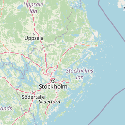
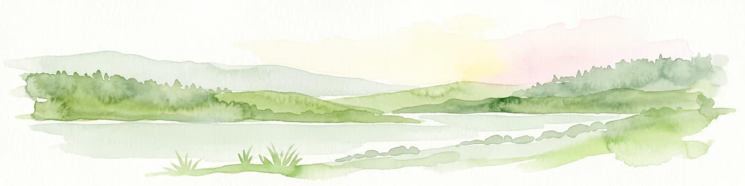
Ängsö National Park occupies a single island in Stockholm's northern archipelago, within the inner archipelago region of Roslagen. The island's landscape is characterized by a harmonious blend of open meadows, pastures, and deciduous woodland, representing a cultural landscape shaped by agricultural use over centuries. The terrain is relatively gentle, with the island's highest points offering views across the surrounding archipelago waters.

The former sound between what were once two separate islands has become a central meadow area called Stormaren, now one of the park's most distinctive landscape features. This area, along with other meadow sections like Långängen and Adamsängen, forms the heart of the park's open landscape. The forest areas, covering roughly a third of the park, contain some of the best-preserved woodland in the Stockholm archipelago, with old oaks, ashes, maples, and birches providing both ecological value and visual character.

The island can only be accessed by boat, with natural harbors along its shores providing landing points. A historic wharf serves as the main arrival point for visitors traveling from the mainland. The eastern shore contains a bird protection zone, with access restricted from February 1 to August 15 to protect nesting bird populations. The landscape retains a remote and unspoiled quality that distinguishes it from the more developed areas of the surrounding archipelago.

Grassy field bordered by weathered wooden fence with dense forest and large tree in background under partly cloudy sky
Cultivated field with wooden fence and forested background in Ängsö National Park

Ängsö National Park ecosystems, habitats, and plant life

The ecological character of Ängsö National Park is defined by its combination of flower-rich meadows and well-preserved deciduous forest, representing one of the most significant natural environments in the Stockholm archipelago. Forest covers approximately one-third of the park's area and is considered among the best-preserved in the region, supporting rare trees, shrubs, and flowering plants that have largely disappeared from surrounding areas.

The meadow environments support diverse plant communities, with cowslip and wood anemones among the notable flowering species that thrive in the open grassland areas. These meadows represent the legacy of traditional agricultural practices that maintained the open landscape through mowing and grazing. The forest ecosystem is dominated by oak, ash, maple, and birch—species that characterize old-growth deciduous woodland in this part of Sweden. The interplay between open meadow and closed forest creates a diverse habitat structure that supports multiple ecological communities.

The park's position in the archipelago creates a transition between terrestrial and marine environments, with coastal habitats along the shoreline complementing the terrestrial communities. The eastern portion of the island serves as a bird protection zone, reflecting the area's significance for breeding birds.

Yellow and red sign with Swedish text prohibiting entry to Ängsö National Park during specific dates, set in a forested area
Swedish sign prohibiting entry to Ängsö National Park during specific dates

Ängsö National Park wildlife and species highlights

Ängsö National Park supports important bird populations that nest in both the woodland and open meadow habitats. Ospreys and eagles are among the notable raptors that can be observed on the island, using the tall trees for nesting sites. The bird protection zone on the eastern shore specifically safeguards nesting areas during the sensitive breeding season, with access restrictions in place from early February through mid-August.

The woodland provides habitat for numerous songbirds and other species that nest in the trees and undergrowth. While the English source notes that many birds nest in the trees, specific species are not extensively documented in the available sources. The forest's mix of old oaks, ashes, maples, and birches creates a structurally diverse habitat that supports cavity-nesting species and provides feeding opportunities for a range of birds. The open meadows, while not detailed extensively in the sources, contribute to the overall biodiversity by providing different habitat types within the island's limited area.

Green meadow with scattered trees and forest background under blue sky with clouds
Adamsängen, Ängsö National Park, Norrtälje Municipality

Ängsö National Park conservation status and protection priorities

Ängsö National Park represents an important conservation case study in Sweden, demonstrating both the value of protecting cultural landscapes and the challenges of managing such environments. As one of Sweden's original nine national parks, established in 1909, it was specifically designated for its remarkable flower-rich cultural landscape—a choice that reflected early recognition that certain landscapes require active management to maintain their ecological and visual character.

The park's history illustrates the consequences of passive conservation approaches. Following national park establishment, authorities initially allowed the landscape to succeed toward forest, believing that eliminating human activity would improve the environment. By the 1930s, it became clear that this approach was destroying exactly what made the park valuable—the open meadows and flower-rich grasslands that depended on continued management. The subsequent restoration work, beginning in the 1940s and continuing through the 1980s, sought to return the landscape to its state at the time of the park's founding.

The park is classified as IUCN Category II (National Park), reflecting its primary conservation purpose while allowing for limited public enjoyment. The designation of a bird protection zone on the eastern shore demonstrates ongoing conservation management, with seasonal access restrictions protecting breeding bird populations. Today, the park represents one of the best-preserved forest environments in the Stockholm archipelago, with the combination of protected forest, managed meadows, and specific species protection measures creating a multi-layered approach to conservation.

Ängsö National Park cultural meaning and human context

Ängsö's cultural history is deeply intertwined with its landscape and reflects centuries of human interaction with the archipelago environment. The island was historically part of the Väringsö kronofogdehemman (tax collector's estate) and was used for producing hay through the traditional practice of slått. The name itself—Ängsö meaning "meadow island"—reflects this agricultural heritage.

The story of the island's human inhabitants adds a personal dimension to its cultural context. Erik Hansson became the first permanent resident in 1725, establishing a croft that would be home to subsequent generations. The last torpare, Adam Michelsen, came from Livland (present-day Estonia) and worked as a farmhand on Väringsö before establishing his own holding on Ängsö. After his early death, his widow Carolina remained on the island into the early 20th century, becoming known in the local area for her healing knowledge. The places associated with this history—Adamsängen (Adam's meadow), Adamskogen (Adam's forest), and Adamsudden (Adam's point)—retain their names today.

The park's cultural landscape represents the legacy of traditional land management practices that created the conditions for the rich biodiversity it protects. The meadows and pastures that define Ängsö's character are not pristine wilderness but rather the product of human activity working in concert with natural processes over centuries.

A forest scene with tall trees, green undergrowth, and white wildflowers on the forest floor
Dense forest interior of Ängsö National Park with green undergrowth and white wildflowers

Top sights and standout views in Ängsö National Park

Ängsö National Park stands out among Swedish protected areas for its combination of accessibility, ecological value, and cultural significance. The island's flower-rich meadows are exceptional in the Stockholm archipelago, supporting plant species like cowslip and wood anemones that have become rare in the surrounding region. The deciduous forest—dominated by oak, ash, maple, and birch—is cited as one of the best-preserved in the archipelago. The park's birdlife, including ospreys and eagles, adds another dimension to its natural appeal, with specific protection measures in place for nesting areas.

The park's island setting and boat-only access contribute to its character as a destination that feels genuinely remote despite being relatively close to Stockholm. The historic wharf and natural harbors provide a classic archipelago arrival experience. The management approach, which has worked to restore the landscape to its early 20th-century character following early mistakes, demonstrates ongoing commitment to preserving the park's distinctive qualities. As one of Sweden's original nine national parks, Ängsö carries historical significance alongside its ecological and landscape value.

Two individuals standing by a wooden gate in front of red wooden houses with a forested background.
Two people conversing by a wooden gate in Ängsö National Park, including a nature warden from the Stockholm County Administrative Board.

Best time to visit Ängsö National Park

The most favorable time to visit Ängsö National Park is during the summer months when regular boat services operate from central Stockholm to the island. The summer season brings the meadows into full flower, showcasing the park's renowned flower-rich landscape at its most spectacular. Visitors can also take advantage of the extended daylight hours to explore the island's trails and enjoy the archipelago setting.

For those interested in birdlife, the spring and early summer period offers the best opportunities to observe nesting birds, though visitors should be aware that the eastern shore's bird protection zone has restricted access from February 1 to August 15. The shoulder seasons of late spring and early autumn may offer quieter visits with fewer crowds, though boat services may be less frequent. The island's character changes with the seasons—autumn brings different colors to the deciduous forest, while the winter months are less suitable for visiting given the island's boat-only access and the general dormancy of the landscape.

Park location guide

Geography guide, regional context, and park location map for Ängsö National Park

Ängsö National Park park geography, regions, and map view in Sweden
Understand where Ängsö National Park sits in Sweden through a broader geographic reading of the surrounding landscape, nearby location context, and its mapped position within the national park landscape.

How Ängsö National Park fits into Sweden

Sweden, formally the Kingdom of Sweden, is a highly developed Nordic country on the Scandinavian Peninsula in Northern Europe. With a population of 10.6 million and an area of 450,295 km², it is the largest Nordic country by both area and population. Sweden is a constitutional monarchy with Stockholm as its capital and largest city, known for its advanced economy, social welfare system, and membership in the European Union and NATO.

Wider geography shaping Ängsö National Park in Sweden

Sweden occupies the eastern portion of the Scandinavian Peninsula in Northern Europe. It borders Norway to the west and north, Finland to the east, and shares a maritime border with Denmark to the southwest across the Øresund. The country has an extensive coastline along the Baltic Sea and Gulf of Bothnia, dotted with thousands of islands. The terrain varies from mountainous regions in the northwest to low-lying coastal areas and inland lakes in the south and central parts.

Map view of Ängsö National Park

Use this park location map to pinpoint Ängsö National Park in Sweden, understand its exact geographic position, and read its mapped placement within the surrounding landscape more clearly.

Pigeon | © OpenStreetMap contributors

Location context for Ängsö National Park

Stockholm County

Explore the Unique Cultural Landscape, Flower Meadows, and Deciduous Forests of this Swedish Island Park

Ängsö National Park Photos: Visual Guide to Island Landscapes and Archipelago Views
Browse a curated collection of imagery from Ängsö National Park, showcasing its distinctive flower-rich meadows, ancient deciduous forests, and serene island archipelago environments. These photographs provide essential visual context for understanding the park's ecological character, protected habitats, and historically shaped terrain within the Stockholm region.

Wide green meadow with scattered yellow wildflowers, bordered by dense forest, under blue sky with white clouds

Wooden pier with tire fenders extending into calm water, surrounded by lush green trees and a red building on the shore

Grassy field bordered by weathered wooden fence with dense forest and large tree in background under partly cloudy sky

Yellow and red sign with Swedish text prohibiting entry to Ängsö National Park during specific dates, set in a forested area

Green meadow with scattered trees and forest background under blue sky with clouds

Man with walking stick standing in a grassy field with purple flowers and trees

A forest scene with tall trees, green undergrowth, and white wildflowers on the forest floor

Two individuals standing by a wooden gate in front of red wooden houses with a forested background.

Moss-covered tree stump surrounded by green vegetation and rocks in a forested area

Park atlas

Explore regional park geography and compare protected landscapes across Stockholm County's archipelago.

Discover Other National Parks and Protected Areas Near Ängsö National Park in Stockholm County
Continue your exploration beyond Ängsö National Park by browsing other national parks and protected areas within Stockholm County. Compare diverse island environments, coastal nature, and cultural landscapes to gain deeper insight into the regional conservation efforts and mapped geography.
National parkStockholm County

Tyresta National Park: Explore Protected Old-Growth Forest and Rift Valley Landscape

Stockholm County National Park, Sweden

Tyresta National Park stands as a crucial protected area, showcasing one of southern Sweden's largest expanses of old-growth coniferous forest, featuring trees up to 400 years old. Its distinctive rift valley terrain, lakes, and post-fire recovery zones offer a rich geographic profile for atlas exploration. Within Stockholm County, this national park provides essential context for understanding the preservation of ancient forest ecosystems and unique geological formations.

Area
20 km²
Established
1993
IUCN
II
Relief
Mixed relief
National parkVästmanland County

Färnebofjärden National Park: Protected River Landscape and Birdlife Atlas

Explore Västmanland County's unique riverine protected area and mapped terrain.

Färnebofjärden National Park offers a unique geographic perspective as a protected national park situated in Sweden's Västmanland County. This page details the park's distinct riverine landscape, characterized by the Dalälven River's intricate network of channels, wetlands, and islands, and its position at a critical ecological frontier. Discover the mapped boundaries and regional context of this important protected area, renowned for its exceptional bird populations and diverse natural habitats.

Area
101 km²
Established
1998
IUCN
II
Relief
Lowland
National parkFinland

Archipelago National Park: Mapped Protected Landscape and Geographic Context in Finland

Explore protected area boundaries and natural terrain.

Archipelago National Park represents a vital component of Finland's protected lands. This page serves as an atlas-focused entry point, detailing the park's specific geographic context, its mapped protected area boundaries, and the nature of its landscape. Understand how this national park contributes to the broader regional geography of Finland and the Nordic region, aiding structured discovery through maps and geographic data.

Area
500 km²
Established
1983
IUCN
II
Visitors
78.8K annual
National parkSouthwest Finland

Bothnian Sea National Park: Southwest Finland's Coastal Protected Landscape

Mapped geography and regional protected area context.

Bothnian Sea National Park stands as a significant protected landscape situated within the extensive island formations of Southwest Finland's Archipelago Sea. This page provides an atlas-focused view of the national park, detailing its geographic spread, mapped boundaries, and its place within the regional context of Varsinais-Suomi. Understand the protected area's unique coastal identity and its contribution to the mapped natural terrain of southern Finland, facilitating structured discovery and geographic exploration.

Area
917 km²
Established
2011
IUCN
II
Visitors
79.4K annual
National parkÖrebro County

Garphyttan National Park: Pioneer Protected Landscape and Historic Swedish Terrain

Explore meadows, forests, and historic geography in Örebro County.

Garphyttan National Park, established in 1909, is a testament to early Swedish nature conservation efforts. This protected landscape features rolling forested terrain and distinctive flower-rich meadows, maintained through traditional practices that highlight Sweden's cultural heritage. Located within Örebro County, the park offers valuable insights into regional geography and the formation of mapped protected areas, making it a key destination for understanding historical landscape preservation.

Area
1.11 km²
Established
1909
IUCN
II
Relief
Lowland
Marine protected areaSaare County

Vilsandi National Park: Marine Protected Area Atlas and Archipelago Geography

Explore the protected landscape of Western Saaremaa's coast.

Vilsandi National Park is an integral part of Saare County's protected lands, recognized as a significant marine protected area. This page offers an atlas-style exploration of its geography, focusing on the distinctive archipelago terrain, coastal formations along Saaremaa's western edge, and its vital importance as a stopover for migratory birds. Understand the park's mapped boundaries and its place within the broader Baltic Sea ecosystem through detailed geographic context.

Area
241 km²
Established
1957
Relief
Lowland
Climate
Temperate
Watercolor painting showing green hills, trees, and a stream in a landscape
National parkSouthwest Finland

Kurjenrahka National Park: Southwest Finland's Protected Landscape Atlas Entry

Discover geographic context and park boundaries.

Delve into Kurjenrahka National Park, a designated national park situated in Southwest Finland. This page provides an atlas-focused view of the park, detailing its protected landscape identity, mapped terrain, and its specific geographic location within the broader Finnish region. Understand the park's ecological context and its significance as a key protected area for regional geographic exploration.

Area
29 km²
Established
1998
IUCN
II
Visitors
66.8K annual
National parkSouthwest Finland

Teijo National Park: Mapped Boundaries of a Protected National Park in Southwest Finland

Explore the geographic context and protected landscape of Teijo National Park.

Teijo National Park is a designated national park within Southwest Finland, offering a distinct protected landscape for atlas exploration. This entry focuses on its geographic identity, mapped park boundaries, and its place within the broader regional geography. Discover the structured details of Teijo National Park as a key protected area, providing valuable context for understanding natural landscapes and conservation efforts in Finland.

Area
34 km²
Established
2015
IUCN
II
Visitors
92.1K annual

Common questions about visiting, size, designation, and location context for Ängsö National Park

Ängsö National Park FAQs for park facts, access, geography, and protected area context
Find quick answers about Ängsö National Park, including protected-area facts, park geography, trail and visitor context, and how the park fits into its surrounding country and regional landscape.
MoriAtlas Explorer

Continue Your Protected Areas Search Across the Global Atlas

Deepen your exploration by continuing the structured search for national parks and protected areas worldwide. Utilize the comprehensive filtering capabilities to compare different conservation landscapes and refine your understanding of global park geography. Discover more about the distribution and characteristics of protected natural areas.

Global natural geography