
Straits
Park geography
A detailed look at regional distribution, marine area extent, and physical landscape context
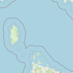
Comprehensive Geographic Profile and Mapped Boundaries of Apollo Marine Park in Victoria
The geographic profile for Apollo Marine Park provides a detailed examination of its marine-based terrain within the temperate climate zone of Victoria, Australia. This overview covers the total marine area of 1184 square kilometers and the park's physical relationship to the Bass Strait. Discover structured data regarding the distribution of protected marine environments and regional land-water connectivity.
Related tags
Bass Straitmarine parksubmarine canyonOtway DepressionCommonwealth marine reserve
A Bass Strait marine reserve protecting deep submarine canyons and submerged ice-age landscapes off Victoria's coast.
Apollo Marine Park
Apollo Marine Park is an Australian Marine Park in Bass Strait, lying off the southern coast of Victoria and near King Island in the far north-west of Tasmania. It covers roughly 1,180 square kilometres of offshore waters and seabed, and forms part of the South-east Marine Parks Network managed by Parks Australia. Established in 2007, the park safeguards a remarkable submarine landscape, including a deep undersea valley that once linked an ancient landlocked Bass Basin to the open ocean. The marine park's principal geographic feature is the Otway Depression, a drowned valley reaching around 100 metres in depth that connects the Bass Basin with deeper ocean waters. This submerged terrain preserves the geological traces of the Bass Lake and river systems that drained the exposed Bassian Plain during the last ice age, making Apollo Marine Park an important site for understanding how sea level rise reshaped southeastern Australia. The whole reserve is zoned as a Multiple Use Zone, meaning activities such as recreational and some forms of commercial use can occur under appropriate management. Beyond its geological interest, the park also carries historical significance. The wreck of the MS City of Rayville, the first American vessel lost during World War II, lies within its boundaries near Cape Otway. The combination of deep submarine topography, fossil river systems and a wartime shipwreck gives Apollo Marine Park a layered identity as a place where natural history and human history intersect beneath the waves of Bass Strait.
- Location
- Australia
- Park type
- Marine protected area
- Established
- 2007
- Area
- 1,184 km²
Location overview
Country and regional administration within Victoria, Australia
Apollo Marine Park Geographic Overview and Regional Location
Apollo Marine Park is located within Australia and administered by the state of Victoria. Recorded records verify its designated marine status within the regional membership structure.
- Countries
- Australia
- Regions
- Victoria
- Primary location
- Victoria
- Geographic setting
- Inland · Marine
Boundary and coordinates
Interactive boundary geometry and derived spatial measurements
Apollo Marine Park Boundary Map and Spatial Extent
Mapped geographic outlines establish clear spatial context for the marine protected area. Structured boundary metrics supply calculated area spans, coordinate limits, and regional extent.
- Boundary area
- 1,183.6 km²
- Boundary perimeter
- 183.6 km
- Northernmost point
- 38.9111° S
- Southernmost point
- 39.35° S
- Easternmost point
- 144° E
- Westernmost point
- 143.5014° E
- Geographic centre
- 39.1891° S, 143.6862° E
- North–south span
- 48.7 km
- East–west span
- 43.1 km
Terrain and natural features
Explore recorded lowland classifications and maritime terrain features
Apollo Marine Park Terrain and Named Natural Features
Stored lowland terrain classifications define the protected landscape geography of Apollo Marine Park alongside recorded natural features located within its boundaries. Linked feature cards provide verified names, types, measurements, and spatial relationships.
Selected named natural features
Environmental setting
Temperate coastal lowland terrain with dominant marine water presence
Apollo Marine Park Environmental Setting and Marine Habitat Classifications
Recorded classifications frame the physical setting through coastal, marine, and temperate categories. Connected atlas destinations link these environmental records to broader regional geographies.
- Relief
- Lowland
- Climate
- Temperate
- Water
- Water-dominated
- Forest cover
- No forest cover
- Seasonality
- Year-round
Landscape features
Coast
Habitat types
Marine habitat
Park atlas
Compare adjacent marine reserves and discover connected coastal landscapes across Bass Strait
Exploring Parks Near Apollo Marine Park And Protected Areas In The Surrounding Region
Visitors exploring Apollo Marine Park can browse adjacent marine reserves and protected areas across Bass Strait to compare submerged topography and regional conservation networks. Expanding the geographic scope reveals broader patterns in offshore geology, marine habitats, and protected landscapes.
National parkAustralia
5.9 km away#1 closest
North

Great Otway National Park: Discover Its Mapped Boundaries and Unique Temperate Rainforest Geography
Explore the diverse terrain and protected landscape of Victoria's coastal ranges.
Great Otway National Park represents a vital protected natural area, distinguished by its dramatic confluence of coastal features and lush inland temperate rainforests. Situated within the Otway Ranges, the park's mapped landscape includes rugged coastlines, V-shaped valleys, and numerous waterfalls that cascade through ancient fern gullies. Understanding the park's geographic setting and protected area status is central to appreciating its ecological significance and its place within the broader Australian conservation landscape. This detailed view allows for in-depth exploration of its unique terrain and protected natural resources.
- Area
- 1,032 km²
- Established
- 2005
- IUCN
- II
- Relief
- Mountain
Marine protected areaAustralia
34 km away#2 closest
Northwest
Twelve Apostles Marine National Park: Protected Landscape and Marine Atlas Exploration
Mapping iconic rock stacks and underwater reef geography.
Twelve Apostles Marine National Park, located on Victoria's south coast, is a key marine protected area renowned for its striking limestone rock stacks and the diverse underwater ecosystems they shelter. This park offers a unique opportunity for atlas exploration, detailing the mapped boundaries and the fascinating marine geography from cliff faces to submerged reefs. Understand the protected landscape and its integral role within Australia's coastal conservation network.
- Area
- 75 km²
- Established
- 2002
- IUCN
- II
- Climate
- Temperate
National parkAustralia
38 km away#3 closest
Northwest
Port Campbell National Park: Iconic Limestone Cliffs and Coastal Protected Area
Explore the mapped geography of Victoria's dramatic Shipwreck Coast.
Port Campbell National Park, a prominent national park in Victoria, Australia, offers an unparalleled atlas exploration of coastal geology. Its landscape is defined by towering limestone cliffs, iconic offshore rock stacks such as the Twelve Apostles, and numerous natural arches and blowholes sculpted by the Southern Ocean. This protected area provides critical geographic context for the Shipwreck Coast's dramatic terrain and serves as a focal point for understanding Australia's dynamic natural heritage.
- Area
- 17.5 km²
- Established
- 1964
- IUCN
- II
- Visitors
- 2M annual
Marine protected areaTasmania
49 km away#4 closest
Southwest
Zeehan Commonwealth Marine Reserve: Geographic Map and Protected Marine Landscape Overview
Deep-sea habitats and shelf bathymetry off the Tasmanian coast
Spanning from fifty meters to over three thousand meters deep, the Zeehan Commonwealth Marine Reserve represents a massive, bathymetrically diverse protected area in the southern Indian Ocean. This geographic overview highlights the reserve's role in conserving limestone seabed features and deep-sea corridors west of Tasmania, offering a clear perspective on its location and scale within the broader regional marine network.
- Area
- 19,897 km²
- Established
- 2007
- IUCN
- VI
- Relief
- Lowland
National parkAustralia
About 74 km away#5 closest
Northeast
Point Addis Marine National Park: Victoria's Protected Coastal Atlas
Mapped marine park and coastal landscape context.
Point Addis Marine National Park is a significant protected marine area situated along the renowned Surf Coast of Victoria, Australia. This park safeguards the coastal waters and shoreline around iconic locations like Bells Beach, preserving vital marine habitats including extensive rocky reefs and kelp forests. Its geography is defined by dramatic sandstone cliffs and the influence of the Southern Ocean, making it a crucial site for understanding temperate marine ecosystems within a popular recreational region. Discover its mapped boundaries and ecological significance for regional geography.
- Area
- 46 km²
- Established
- 2002
- IUCN
- II
- Climate
- Temperate
Protected areaVictoria
About 103 km away#6 closest
Northwest
Framlingham Forest Indigenous Protected Area: Geography and Landscape Overview
Aboriginal-owned savanna woodlands in Western Victoria
Framlingham Forest Indigenous Protected Area is an important cultural and ecological site in south-western Victoria. Spanning over 1,100 hectares of stringybark and manna gum savannah, this protected area offers a unique glimpse into the native woodland ecosystems that once defined the Western District plains near the Hopkins River.
- Area
- 11.3 km²
- Established
- 2009
- Relief
- Lowland
- Scope
- Terrestrial
National parkAustralia
About 109 km away#7 closest
Northeast
Point Nepean National Park: Protected Coastal Landscape & Geographic Context
Discover the mapped boundaries of this Australian national park.
Point Nepean National Park represents a vital protected landscape situated at the southern extremity of the Mornington Peninsula, Australia. This national park encompasses a rugged headland that forms the critical entrance to Port Phillip Bay, characterized by striking limestone cliff formations and coastal ecosystems. As a site of historical military importance, Point Nepean National Park offers a distinct geographic identity and a unique protected area for atlas-based exploration and understanding its regional context.
- IUCN
- II
National parkAustralia
109 km away#8 closest
Northeast
Mornington Peninsula National Park: Victoria's Coastal Protected Landscape and Map Atlas
Explore dramatic cliff-top terrain, sandy beaches, and native bushland.
Mornington Peninsula National Park is a protected natural area defined by its spectacular coastal geography in Victoria, Australia. The park features striking cliff-top vistas, extensive sandy beaches, and sculpted dunes that showcase the dynamic forces shaping Australia's coastline. Its mapped boundaries protect a vital landscape including areas like Greens Bush, offering a glimpse into the region's native vegetation and geological formations for those interested in detailed geographic context and protected area exploration.
- Area
- 26.86 km²
- Established
- 1995
- IUCN
- II
- Relief
- Mixed relief
MoriAtlas Explorer
Trace the Submerged Terrain and Boundaries of Apollo Marine Park
Investigate the complex underwater geography of Apollo Marine Park through a structured atlas view. This MoriAtlas destination provides context on the Otway Depression, regional seabed features, and protected area zoning that defines this significant marine reserve in the Bass Strait.
Browse next
Global natural geography
Explore related park routes
Explore MoriAtlas Global ParksBrowse All MoriAtlas ParksGlobal Park Map DiscoveryMoriAtlas: Browse All CountriesBrowse All MoriAtlas ContinentsNational Park Environment AtlasGrand Canyon National Park AtlasYellowstone National Park AtlasYosemite National Park Atlas and GeographySerengeti National Park AtlasGalápagos National Park Protected LandscapeBanff National Park Geography and AtlasKruger National Park Atlas EntryUluṟu-Kata Tjuṯa National Park AtlasExplore Uluru-Kata Tjuta National Park GeographyPlitvice Lakes National Park AtlasFiordland National Park Protected LandscapeGreat Smoky Mountains National Park AtlasAfghanistan National Parks and Protected AreasAlbania National Parks and Protected AreasAlgeria National Parks and Protected AreasAmerican Samoa National Parks and Protected AreasAndorra National Parks and Protected AreasAngola National Parks and Protected AreasAntarctica National Parks and Protected AreasAntigua and Barbuda Park List