Mori Atlas logo
National parkAvdat National Park

Discover the mapped boundaries and regional landscape context of Avdat National Park.

Avdat National Park: Explore Israel's National Park Landscape and Protected Area Geography

Avdat National Park stands as a significant protected area within Israel's diverse geography. This page provides detailed atlas-style exploration of the park's protected landscape, focusing on its mapped boundaries and its role within the regional context of the country. Understand the core geographic identity of Avdat National Park as a key component of Israel's conservation efforts and natural terrain.

IsraelNegev DesertNational ParkProtected AreaMiddle EastDesert Landscape

Avdat National Park

National park

Park overview

Structured park overview, official facts, and landscape profile for Avdat National Park

Avdat National Park park facts, protected area profile, and essential visitor context

Review the core facts for Avdat National Park, including designation, size, terrain, visitor scale, habitats, and operating context in one park-focused overview.
Protection and recognition

Analyzing the official terrestrial scope and regional designation framework

Documented Protection Status and Conservation Profile of Avdat National Park

Atlas users can examine the documented protection status, official terrestrial designation scope, and management frameworks associated with Avdat National Park. Verifying formal boundaries and regional designations helps researchers map the official conservation footprint of key arid archaeological and historical landscapes.

Protection details

Protection scope
Terrestrial
Transboundary protection
No
Monthly climate preview

Trace measured monthly temperature averages and precipitation patterns across the representative point.

Avdat National Park Climate Normals, Long-Term Temperature and Precipitation Rhythms

Long-term satellite measurements outline a rhythmic progression of monthly temperature averages and low precipitation values across Avdat National Park. Accessing the complete twelve-month climatology dataset reveals detailed variations in average minimum and maximum temperatures throughout the year.
Annual mean20 °C
11 °C28 °C
Jan11°
Feb12°
Mar15°
Apr19°
May23°
Jun26°
Jul28°
Aug28°
Sep26°
Oct23°
Nov18°
Dec13°
Warmest month
August

28.1 °C

Coolest month
January

10.8 °C

Wettest month
January

1.3 mm/day

Driest month
June

0 mm/day

Park location guide

Geography guide, regional context, and park location map for Avdat National Park

Avdat National Park park geography, regions, and map view in Israel

Understand where Avdat National Park sits in Israel through a broader geographic reading of the surrounding landscape, nearby location context, and its mapped position within the national park landscape.

How Avdat National Park fits into Israel

Israel is a parliamentary republic in the Southern Levant, established in 1948 as a Jewish homeland. It borders Lebanon, Syria, Jordan, and Egypt, with Mediterranean coastline and access to the Red Sea. Jerusalem is the capital, though its status is contested, while Tel Aviv is the largest urban area. The country has a high-income economy with strong technology and innovation sectors.

Wider geography shaping Avdat National Park in Israel

Israel occupies the Southern Levant region of West Asia. It is bordered by Lebanon to the north, Syria to the northeast, Jordan to the east, and Egypt to the southwest. The western coast lies on the Mediterranean Sea, while the southern tip reaches the Red Sea. The eastern border includes the Dead Sea, Earth's lowest point. The country occupies the West Bank, Gaza Strip, and Golan Heights.

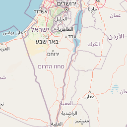
Map view of Avdat National Park

Use this park location map to pinpoint Avdat National Park in Israel, understand its exact geographic position, and read its mapped placement within the surrounding landscape more clearly.

Pigeon | © OpenStreetMap contributors

Location context for Avdat National Park

Negev
Park atlas

Compare surrounding desert landscapes and regional protected areas across Israel, offering broader geographic context.

Explore Nearby National Parks and Protected Areas Beyond Avdat National Park

Continue your exploration beyond Avdat National Park to discover other significant protected areas and national parks across the Negev Desert region. Browsing these adjacent conservation landscapes offers valuable geographic comparison, revealing the spread of protected terrain and diverse ecological zones within Israel and the Middle East.
Watercolor illustration of a canyon with winding river, mountains, and rolling hills
National parkIsrael
About 3.6 km away#1 closest

North

Ein Avdat National Park: A Spectular Desert Oasis and Protected Landscape in Israel

Explore its unique springs, waterfalls, and ancient Nabatean and Byzantine history.

Ein Avdat National Park showcases a rare desert oasis environment, a starkly beautiful protected landscape where natural springs emerge from the Negev's arid terrain. This park is celebrated for its dramatic waterfalls, deep pools, and the preserved remnants of ancient human habitation, including a remarkable Byzantine cave monastery carved directly into the canyon walls. Its geography, shaped by the Nahal Zin wadi, provides a vivid study in desert ecosystems and their capacity for supporting life and history over millennia, making it a key site for understanding landscape context in Israel.

Area
4.8 km²
IUCN
V
Relief
Mixed relief
Climate
Arid
National parkIsrael
About 6.5 km away#2 closest

North

Ben-Gurion Tomb National Park: Protected Desert Landscape and Geographic Context

Explore the Negev Desert's unique memorial terrain.

Ben-Gurion Tomb National Park offers a distinct protected landscape experience in the heart of Israel's Negev Desert. This national park is primarily known as the burial site of David and Paula Ben-Gurion, intentionally situated in the desert overlooking the dramatic Nahal Tzin canyon. The park's approximately 90 dunams feature a carefully designed memorial garden that contrasts with the arid terrain, providing a unique focus for geographic exploration and understanding the site's regional landscape.

Area
0.09 km²
Relief
Lowland
Climate
Arid
Access
Easy access
National parkIsrael
About 17 km away#3 closest

Northwest

Shivta National Park National Park: An Atlas View of Israel's Protected Landscapes

Mapped terrain and regional geographic context for Shivta National Park.

Shivta National Park represents a key protected area, offering a focused entry into Israel's broader geographic and landscape atlas. This page provides specific details about the park's identity as a national park, its mapped terrain, and its placement within the regional context of the country. Users can explore the structured information that defines Shivta National Park's role as a protected landscape, contributing to a deeper understanding of its geographic significance and mapped features.

Climate
Arid
Access
Easy access
Scope
Terrestrial
Water
No major water
National parkIsrael
About 24 km away#4 closest

South

Makhtesh Ramon National Park: Israel's Premier Erosion Cirque & Geological Wonder

Discover dramatic desert terrain and ancient, colorful rock formations.

Makhtesh Ramon National Park in Israel's Negev Desert is the world's largest erosion cirque, a vast 40-kilometer depression revealing millions of years of geological history. Its striking landscape features colorful clay hills, ancient volcanic remnants, fossil beds, and unique sandstone formations, making it an unparalleled destination for understanding Earth's past through its protected natural terrain. Explore the mapped boundaries and regional context of this extraordinary desert formation.

Relief
Mountain
Climate
Arid
Access
Moderate access
Scope
Terrestrial
Watercolor illustration of rolling green hills, a body of water, and grassy vegetation under a light sky.
National parkIsrael
About 38 km away#5 closest

Northeast

Mamshit National Park: Ancient Nabataean City, Byzantine Ruins, and Negev Desert Landscape

Explore exceptionally preserved Nabataean urban architecture and regional geography.

Mamshit National Park offers a rare window into ancient desert urbanism, preserving an exceptionally intact Nabataean caravan city and Byzantine settlement in Israel's Negev Desert. The site showcases unique residential compounds and religious structures, demonstrating sophisticated architectural traditions and water management systems against a backdrop of striking natural terrain. As a vital component of the Incense Road heritage, Mamshit provides rich context for understanding ancient trade, regional geography, and the enduring human adaptation to arid landscapes.

IUCN
V
Relief
Lowland
Climate
Arid
Scope
Terrestrial
National parkIsrael
About 50 km away#6 closest

North

Tel Be'er Sheva National Park: Mapped Boundaries and Protected Landscape Identity

Discover its geographic context within Israel's natural terrain.

This MoriAtlas detail page for Tel Be'er Sheva National Park provides focused insights into its identity as a protected landscape. Users can explore its specific geographic setting within Israel, understand its mapped boundaries, and gain a clearer appreciation for its natural terrain. The content is designed to support detailed atlas-based discovery, offering a comprehensive view of the park's protected area characteristics and regional geographic significance.

Nature reserveJordan
About 60 km away#7 closest

East

Fifa Nature Reserve Nature Reserve: Protected Landscape Discovery in Jordan

Mapped natural terrain and protected area context.

Fifa Nature Reserve represents a distinct protected natural landscape within Jordan. This entry offers users a detailed atlas-style view of the reserve's protected boundaries and its place within the country's geography. Explore the mapped terrain and understand the significance of this nature reserve for structured geographic discovery and protected-area research.

Area
23.2 km²
Established
2011
Relief
Lowland
Climate
Arid
Watercolor illustration showing a winding river through green hills with distant trees under a light sky
National parkIsrael
About 63 km away#8 closest

Northwest

Eshkol National Park: Desert Wetland Oasis with Archaeological Significance in Southern Israel

Mapped protected area featuring Ein HaBesor spring and Besor valley landscapes.

Eshkol National Park showcases a rare desert wetland environment sustained by the significant Ein HaBesor spring in Israel's Northern Negev. This protected natural area offers a distinctive landscape where water nourishes lush vegetation against the backdrop of arid terrain. Beyond its ecological value, the park encompasses archaeological remnants, including the mound of Khirbet Shalala, providing a rich geographical and historical discovery context within the Besor Stream basin.

Area
3.54 km²
Relief
Lowland
Climate
Arid
Access
Easy access

Common questions about visiting, size, designation, and location context for Avdat National Park

Avdat National Park FAQs for park facts, access, geography, and protected area context

Find quick answers about Avdat National Park, including protected-area facts, park geography, trail and visitor context, and how the park fits into its surrounding country and regional landscape.
MoriAtlas Explorer

Continue Your Protected Areas Search Across the Global Atlas

Deepen your exploration by continuing the structured search for national parks and protected areas worldwide. Utilize the comprehensive filtering capabilities to compare different conservation landscapes and refine your understanding of global park geography. Discover more about the distribution and characteristics of protected natural areas.

Global natural geography