Viewpoints
Bale Mountains Viewpoint
4,377 m

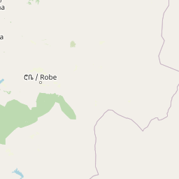
Mapped boundaries, elevation data, and environmental landscape features within the Bale Zone
The geographic profile of Bale Mountains National Park encompasses 2220 square kilometers within the Oromia region of Ethiopia. This territory features mountain landscapes, including the 4385 meter peak of Tullu Dimtu, alpine meadows, montane forests, and diverse river systems such as the Weyib and Webi Gestro.
Related tags
Ethiopia's highland wilderness with Africa's largest Afromontane habitat and endemic wildlife
Bale Mountains National Park is a protected highland wilderness in southeastern Ethiopia, spanning approximately 2,150 square kilometers within the Bale Zone of the Oromia Region. The park encompasses the Bale Mountains and Sanetti Plateau, dramatic alpine terrain that rises to 4,385 meters at Mount Tullu Dimtu, making it one of the highest mountain protected areas in Africa. The park holds the distinction of containing Africa’s largest area of Afromontane habitat, a globally significant ecosystem characterized by montane forests, grasslands, and moorlands that support extraordinary biodiversity. Established in 1970, the park was inscribed as a UNESCO World Heritage Site in 2023, recognizing its outstanding universal value as a center of endemism with one of the highest incidences of animal endemism of any terrestrial habitat in the world. The landscape transitions from the dense Harenna Forest at lower elevations through montane grasslands to the Afro-alpine moorlands of the Sanetti Plateau, creating distinct ecological zones within a relatively compact area.
Protected area positioning within the Oromia region and Bale Zone
Mapping the 2220 square kilometer footprint and coordinate span
Mountain relief range and recorded natural features
Viewpoints
4,377 m
Rivers
Waterfalls
Forests
Rivers
Peaks
4,377 m
Interpreting recorded mountain terrain, forest cover, and diverse plateau habitats
Mountains · Plateau · Forest · Grassland · Wetland
Montane forest · Temperate broadleaf forest · Alpine meadow · Grassland · Wetland
Trace mapped park geography, compare unique Afro-alpine ecosystems, and explore connected protected landscapes across the Ethiopian highlands.
North

Mapped protected terrain and endemic species habitat within the Arsi Zone.
Arsi Mountains National Park is a vast protected area celebrated for its significant biodiversity and distinctive Afro-alpine ecosystems. Situated in the Arsi Zone, this national park encompasses a dramatic mountain landscape central to the Ethiopian Highlands. It serves as a crucial refuge for endangered endemic species, including the mountain nyala and Ethiopian wolf, within its varied ecological zones and protected park boundaries, offering rich context for geographic exploration.
Northwest
Mapped terrain and protected wetland ecology in the Ethiopian Rift Valley.
Explore Abidjatta-Shalla National Park, a significant protected area in Ethiopia renowned for its stunning avian spectacles, particularly the vast flamingo colonies on Lake Abijatta. This national park's landscape is defined by the distinct volcanic geology of the Rift Valley, featuring both shallow alkaline waters and deeper lakes that create diverse wetland ecosystems. Understand its geographic placement within Ethiopia and its importance as a major birdwatching destination, offering insights into unique protected natural landscapes.
Northwest
Mapped landscape and regional geographic context.
Delve into the protected landscape identity of Abijatta-Shalla National Park, a designated national park situated within the Oromia Region. This dedicated detail page offers an atlas-driven perspective, focusing on the park's geographic scope, mapped terrain, and its significance as a protected natural area. Understand its role in the broader context of Ethiopian protected lands and regional geography.
North
Discover the protected landscape of this Ethiopian National Park.
Awash National Park represents a significant protected area within Ethiopia, offering a rich focus for geographic discovery. This page illuminates the park's specific mapped boundaries and its positioning within the surrounding regional geography. It serves as a detailed entry point for understanding the park's landscape character and its role as a national park in East Africa.
West
Explore the mapped geography and protected area context of this Ethiopian park.
Nechisar National Park is designated as a national park, serving as a critical protected natural area within the South Ethiopia Regional State. This MoriAtlas entry provides detailed geographic context, focusing on the park's mapped boundaries and its place within the regional landscape. Users can explore the park's identity as a protected territory, offering a foundation for understanding Ethiopia's natural protected areas through a geographic lens.
West
Discover mapped savanna ecosystems and unique montane geography within this protected Ethiopian landscape.
Maze National Park represents a significant protected area within Ethiopia, vital for the conservation of the endangered Swayne's hartebeest. Its diverse terrain includes savanna grasslands and unique geothermal features such as active geysers, all set against a distinctive montane backdrop. This national park offers a deep dive into Ethiopia's natural heritage, providing a clear geographic identity and valuable context for landscape exploration.
Southeast

Explore the semi-arid bushland and riparian woodland geography.
Malka Mari National Park offers a profound wilderness experience as Kenya's most remote national park, situated along the Dawa River in Mandera County. This protected area features striking contrasts between arid bushland and verdant riparian woodlands, supporting unique plant species and wildlife adapted to the semi-arid environment. Its vast, undeveloped character makes it a significant site for frontier conservation and a unique destination for atlas-style landscape exploration.
Southwest
Explore the mapped boundaries and regional geography.
Gain a detailed understanding of Borana National Park, identified as a national park within the Oromia Region of Ethiopia. This entry focuses on its geographic context, providing mapped information crucial for understanding its protected landscape identity. Examine how Borana National Park fits into the broader atlas of conservation areas, offering a precise view of its unique terrain and regional significance without operational details.
Deepen your atlas exploration by continuing into the detailed geography of Bale Mountains National Park. Understand the specific mapped boundaries and the regional context of this significant Ethiopian national park. This structured approach reveals how protected landscapes like Bale Mountains National Park fit into the larger atlas, offering a unique perspective on conservation areas and natural terrain for dedicated geographic discovery.